
Park at the Gleisdreieck
| Park at the Gleisdreieck | ||
|---|---|---|
|
|
||

|
||
| Map of the three parts of the park | ||
| Basic data | ||
| place | Berlin | |
| District |
Kreuzberg and Schöneberg |
|
| Created | 1990s | |
| Newly designed | 2010s | |
| use | ||
| User groups | Pedestrian traffic , leisure | |
| Technical specifications | ||
| Parking area | 315,000 m² | |
52 ° 29 '44.9 " N , 13 ° 22' 32.8" E
|
||

The Park am Gleisdreieck is a public green and recreational area in Berlin . The approximately 31.5 hectares extensive park is located on the former railway wastelands of Anhalter and Potsdamer freight depot at Gleisdreieck and extends from the Landwehr Canal on the Yorckstraße to Monument Bridge. The facility consists of three parts of the park that were opened between 2011 and 2014:
- Ostpark in Berlin-Kreuzberg , 17 hectares, opened on September 2, 2011,
- Westpark in Berlin-Kreuzberg, 9 hectares, opened on May 31, 2013,
- Bottleneck or Bottleneck Park in Berlin-Schöneberg , 5.5 hectares, opened on March 21, 2014.
The route of the north-south long-distance railway separates the Ostpark from the Westpark. The park, which was partly realized with committed citizen participation, is characterized by wide lawns with lawns and historical relics from the railroad era of the site: The dense wilderness, known as “unsecured”, that develops from the old track systems, remains of signals, track pits and pools of water have their own biotope . In the north, between the parts of the park, are the buildings and facilities of the German Museum of Technology . The city park close to the center has over 30,000 immediate residents.
In the Berlin open space concept , the park forms an important link in the 40-kilometer north-south tangent and to the east-west green corridor .
location
The two main parts of the park, the East and West Park, are located in the extreme west of Kreuzberg; the Westpark borders on Tiergarten , a district of the Mitte district , and on Schöneberg. The Ostpark stretches from the Tempelhof bank of the Landwehr Canal to Yorckstrasse . Möckernstrasse forms the eastern boundary . The narrow bottleneck park is connected to the east park via one of the Yorckbrücken and continues the green corridor to the south to the monument bridge. The former railway site and the park are slightly elevated - almost three meters above street level - on an artificial plateau.
→ For the history of the site, see: History of the Gleisdreieck underground station , Anhalter Güterbahnhof , Potsdamer Güterbahnhof
Planning, financing and citizen participation
As early as the 1970s, residents developed their first ideas for designing the Gleisdreieck as a park. Plans to pull the west bypass through the site were abandoned in 1994 following pressure from a citizens' initiative. In 1997, the State of Berlin and the then railway company Vivico agreed to build the park. The estimated costs of around 18 million euros (based on the East and West Park) were made available to investors in Potsdamer and Leipziger Platz ( DB Netz AG , represented by DB ProjektBau GmbH ; Vivico Real Estate GmbH) as part of a replacement measure. The overall planning and the draft come from Atelier Loidl , whose conception had prevailed in a two-stage landscape planning competition . The building owner was the Senate Department for Urban Development, represented by Grün Berlin GmbH. The Loidl studio was responsible for the overall planning . Work began in June 2008 with the clearing of the area for the Ostpark, followed by landscaping for this first part of the park in August 2010 .
The project-accompanying working group Park am Gleisdreieck (PAG) made up of resident representatives and district councils from the district management areas Schöneberg-Nord and Magdeburger Platz was involved in the planning and work on the first two parts of the park . While the citizens 'initiative, with its wish to preserve as much of the wild growth as possible in the area inaccessible for over 40 years, was only able to prevail to a certain extent, various residents' requests such as a nature experience room and playground for children were taken into account. The bottleneck was planned and implemented without public participation .
The parts of the park
Breakdown according to the location in the urban area
The contrast between the vastness and the small-scale offers forms the landscape design model for the two larger parts of the park. In the narrow bottleneck, railway relics and the so-called "track wilderness" dominate. The wide path next to the railway line in Ostpark and Bottleneck is part of the Berlin – Leipzig cycle path , which is indicated by several long Leipzig-Berlin lettering on the asphalt. The path integrates the green corridor into the national cycle path system .
The dividing railway line between the East and West Park can be bypassed at the north entrances via the Schöneberger Ufer detour on the Landwehr Canal and at the south entrances via Yorckstrasse. In the middle area, the parts of the park are connected by a bicycle road that runs in the Ostpark between the railway line and the underground station area.
An originally planned pedestrian / cycle path bridge over the main line was not built for cost reasons. In a comment, the daily newspaper feared that the route would act like a wall between the Kreuzberg users of the Ostpark and the Schöneberg users of the Westpark and could deepen the division that has already shown in the different planning participation: Here engagement, initiative, citizens' initiatives, the old Kreuzberg mix. There passivity, poverty, drugs, prostitution, problem areas. [...] The scenario is in the room: In Kreuzberg, the alternative scene is taking over the woods and even the lawn. In Schöneberg it's the dealers. These fears have not come true, especially since the neighboring quarters in the west have undergone a strong social upgrade with extensive, largely high-priced new construction projects.
East Park
_30.jpg)
structure
In addition to the large meadow, the park part is characterized by isolated groups of trees, several forests, long wooden benches, sports and play areas, a 'skater spot' and wide, barrier-free asphalted and rounded paths for pedestrians and cyclists. On the south-eastern edge of the site is the area released for residential construction during the conversion: the “Möckernkiez” residential project is being built here (2016).
Entrances, museum train, general train

The Ostpark, which opened on September 2, 2011, has entrances with stairs and / or long ramps:
- at the Technikmuseum , Tempelhofer Ufer, Möckernbrücke underground station ;
- on Möckernstrasse, near Hornstrasse ;
- under the Yorckbrücken at Berlin Yorckstrasse train station .
- Further stairways and ramps are located on Möckernstraße.
The railway track leads through the middle of the park to the German Museum of Technology. On Sundays in September, its museum train runs between the main location on Trebbiner Straße and the depot on Monumentenstraße.
The main route from west to east, which leads across the central square, is called the General Train . The naming was based on the generously laid out sequence of streets and squares of the general train , which leads from Charlottenburg via Schöneberg to Kreuzberg and recalls the Wars of Liberation against Napoleon I of 1813–1815 . The street that was laid out in the 19th century is based, with the exception of the bypass of the Gleisdreieck area, on older plans by Peter Joseph Lenné (from 1841 to 1855) and the Hobrecht plan from 1862. The Parkweg indicates the planned route from Schöneberg to the original one Straight lying Kreuzberger Hornstrasse .
layout
An extensive lawn, the Kreuzberger Wiese, forms the center of the 17 hectare part of the park. Straight concrete paths lead to the Stangenwald and children's play areas, a wood with dry grass areas , a rose-scented garden, boules alleys , table tennis tables and the central square on the loading street of the technology museum. Long wooden benches underline the wide, open character of the park. Numerous resting places are interspersed in the area. On the Möckernpromenade , which runs on the embankment to Möckernstrasse and partly above a renovated, over 100-year-old historical wall, the resting places partly take the form of viewing platforms. There is also a dance floor and an info point for guided tours.
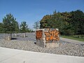
The natural playground, which was not originally planned and implemented by the citizens' initiative, does not have any play equipment and instead offers sand, stones, wood and mud as well as blackberry bushes and apple trees on a hilly terrain. On the 40 years of untouched ruderal areas , 66 large and 500 small trees were felled and around 950 trees and bushes were planted. Parallel to the north-south long-distance railway, gravel areas were created as ecological succession areas for the colonization of beetles and lizards, which are followed by three sports fields, including basketball. The final skate park at the former Poststellwerk has the largest outdoor pool in Berlin. Active skaters were involved in the planning process of the 1,300 m² facility, so that the most modern training options for slides , grinds and flips were created.
- East Park

Entrance Möckernstrasse / Hornstrasse
Gravel areas along the north-south long-distance railway

Stangenwald playground
_02.jpg)
_06.jpg)
_14.jpg)
_11.jpg)
_04.jpg)
West Park
Preparations
The area of the Westpark has been cleared since August 2010, landscaping began in September 2011. The opening of this part of the park was scheduled for autumn 2013, but took place on May 31, 2013. Its costs were estimated at around 8.5 million euros. To the west, the Flottwell- / Dennewitz- / Bülowstraße complete the Westpark. There is also an allotment garden colony in this area .
Entrances and line of sight to the Luther Church
_21.jpg)
_14.jpg)
The Westpark has several accesses: a barrier-free north entrance on Schöneberger Ufer, which is designed as a square-like entrance and leads across the Landwehr Canal to Potsdamer Platz with the Mendelssohn-Bartholdy and Tilla-Durieux parks . Barrier-free access to the east is located on Schöneberger Straße, next to the Gleisdreieck underground station (underground lines U1 and U2). West entrances exist in the extension of Kurfürstenstrasse at the adjacent Nelly-Sachs-Park , in the extension of Lützowstrasse and Pohlstrasse as well as in the extension of Bülowstrasse along the elevated railway viaduct (all barrier-free). The path in the extension of Bülowstrasse continues the general procession and is oriented as a visual axis to the Luther Church on Dennewitzplatz . The tall, slim tower of the church, visible from afar, was arranged at an angle between the polygonal choir and a polygonal transept , so that it lies exactly on the axis between Wittenbergplatz and Südstern . Access from Yorckstraße is possible via the parking lot of a hardware store. Two further south entrances on Yorckstraße, at the S-Bahn station Yorckstraße (Großgörschenstraße) of the S1 and Höhe Bautzener Straße, are still in the planning stage (status 2014).
layout
In addition to a central meadow, the Schöneberger Wiese, the image of the 9-hectare green area is determined by the elevated railway lines of underground line 1 and line 2 , which cross the park from west to east. A Kiezplatz for flea markets , boules and celebrations was created under the viaduct of the U2 . A meadow and a wooden sun deck with an adjoining city beach were laid out on the tunnel mouth of the long-distance railway, from which one has a view over the Westpark, the elevated railway viaducts and the backdrop of Potsdamer Platz. Areas with ruderal meadows and the “ urban wilderness ” area remained partially natural. In the southwestern part of the park already existing allotments were included. There is a café on the market square of the allotment garden colony POG. There are several playgrounds for children as well as climbing frames on the dead straight, paved paths. On a multifunctional sports and play area, in addition to a floor labyrinth and horizontal bars, trend sports such as trampoline gymnastics , roller sports , streetball and goal wall shooting are offered. A small dog exercise area complements the facilities.
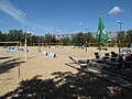
The existing beach volleyball fields of Beach61 are integrated into the park and offer a view of the expanse of the Schöneberg meadows and the gasometer , the 78-meter landmark and the landmark of the Schöneberg Red Island from an urban beach .
Beach61
Between 2004 and 2006, large amounts of sand from the excavation of the Alexa construction site (the sands of Berlin's glacial valley reach a thickness of over 20 meters) were moved from Alexanderplatz to the western Gleisdreieck. On May 1st, 2009, the Beach61 opened on the sand with 25 beach volleyball fields that can be rented by the hour. The multi flexible sandy areas are also for sand sports like beach soccer , beach handball , speedminton and Beachminton as well as for street soccer and street basketball available. Yoga , Tai-Chi , Frisbee and gymnastics for all age groups are offered on an adjacent relaxation area . There are also sanitary facilities, changing rooms and a beach bar. The sports facility is included in the Westpark.
- West Park
Beach volleyball facility "Beach61" on the Westpark

U1 elevated railway line at the Westpark construction site. Gleisdreieck underground station on the right .

Schöneberger Wiese and bridge of the U2 .

Meadow in the northern part of the Westpark with a view of Potsdamer Platz

Playground at the Kurfürstenstrasse entrance
_01.jpg)
_03.jpg)
_22.jpg)
_10.jpg)
_17.jpg)
Bottleneck Park
Preparation, initiation, connections
The landscaping work for the bottleneck or bottleneck park began in April 2013. On March 21, 2014, the 5.5 hectare part of the park was opened with entrances at Monumentenbrücke / -strasse in the south and in Yorckstrasse in the north. The connection to Yorckstraße was made via a ramp with orange barriers, as with the opposite entrance to the Ostpark. The costs for this part of the park were around 2 million euros. The area owes its long-standing name to its shape.
Bridging the Yorckstrasse
_03.jpg)
Changing from one part of the park to the other was initially only possible via the busy Yorckstrasse. Since it had been neglected to provide a set of traffic lights or a zebra crossing in time, the dangerous transition from citizens' initiatives, various media and local politicians such as the Tempelhof-Schöneberg city councilor Sibyll Klotz was heavily criticized.
One of the Yorck bridges was supposed to be used as a bridge, but in March 2014 the administration said that the planned bridge No. 10 had to be dismantled, completely renovated and repaired; the reinstallation could probably only take place in one and a half or two years. Due to public pressure and evidence from citizens' initiatives that this bridge from the 1930s was still used for trains to the Postbahnhof until 1994 and that it was overall in very good condition, the administration decided not to undertake the expensive and time-consuming renovation. The bridge was set up in just four weeks. It was opened on April 17, 2014 between Ostpark and the bottleneck.
At the end of January 2016, bridges 11, 14, 15 and 17 were removed from their supports in the park and transported to a storage area in the immediate vicinity. The on-site renovation actually planned there, however, turned out to be impossible according to the current building regulations and the requirements of the monument protection. An agreement on how to proceed was only reached in mid-2018 and the bridges could be transported to a special company for renovation. In 2019, the four bridges were lifted again and then bridge No. 10 was also renovated by February 2020. In spring 2020 bridges 11, 14 and 17 will finally be connected to the park via the “Yorckpromenade”, bridge no. 15 completes the monument ensemble and is not used as a crossing.
layout
In this part of the park, railway relics and the "track wilderness" dominate. The original vegetation was hardly touched. "When designing the park, particular attention was paid to preserving the typical vegetation of a railway wasteland with pioneer and urban forests, ruderal meadows, semi-dry and sandy dry grass." In particular, three paths were laid out from Yorckstraße from north to south and in the ever narrowing area converge in a small, designed space at the railway relict signal box. The concrete path on which the Berlin – Leipzig cycle path continues, runs through the rest of the park area to the Monumentenbrücke. A track that was filled with foot-friendly bark mulch was used for one of the three paths . A few long benches and towering swings complement the restrained design of the wooded area.
At the southern end of the park at the Monumentenbrücke, Monumentenplatz was created as a gateway to the Gleisdreieckpark as part of the West Urban Redevelopment . The new town square, which borders the locomotive depot of the German Museum of Technology to the north, includes references to the historic railway site in the design. The square is also connected to the north-south green corridor of the Schöneberg Loop, which opened in 2016, via the monument bridge.
- Bottleneck Park

Ascent on Yorckstrasse

Small place at the railway relict signal box

Former signal box

Main path (part of the Berlin-Leipzig long-distance cycle route) and track filled with bark mulch as a byway
Decorative design elements of modern street furniture
_01.jpg)
_04.jpg)
_08.jpg)
_07.jpg)

The park in the Berlin open space concept
As a green connecting element from north to south, the park occupies a key position in Berlin's open space concept, according to the Senate Administration . It is part of the 40-kilometer north-south path, which, as hiking trail 5 of the 20 main green paths in Berlin, leads from north along the Panke to the south to the Teltow Park regional park. To the north, the park closes the gap between the parks at Potsdamer Platz and the Spreebogenpark at the government district. To the south, the Schöneberg Loop will connect to the Schöneberg-Südkreuz development area for urban redevelopment, which was started in 2005 with the aim of integrating the new Südkreuz long-distance train station (formerly Papestraße station ) into the urban environment. In the further south, the Hans-Baluschek-Park and Natur-Park Schöneberger Südgelände are connected to the nearby islanders .
The Schoneberg loop also passes through the east-west green corridor with the central Alfred Lion bridge , the small scale with the Cheruskerpark and spacious east with the Tempelhof Park and to the west with the Heinrich-Lassen Park / Rudolph Wilde Park networked , in turn, as part of a Glacial side channel of Grunewaldseenkette over the public park Wilmersdorf and other green plants at the Grunewald connect.
literature
- Urban redevelopment west. Schöneberg-Südkreuz. Right in the middle of urban redevelopment 2012. Ed .: District Office Tempelhof-Schöneberg of Berlin. Berlin 2012. Brochure (PDF; 2.5 MB)
- Andra Lichtenstein, Flavia Alice Mameli (eds.): Gleisdreieck / Parklife Berlin, transcript Verlag; 2015. ISBN 978-3-8376-3041-1 .
- Leonhard Grosch, Constanze A. Petrow: "Designing parks - Berlin's Park am Gleisdreieck or the art of creating lively places". JOVIS Verlag Berlin 2015, ISBN 978-3-86859-369-3 .
Web links
- Park at the Gleisdreieck . Grün Berlin GmbH.
- Gleisdreieck blog. Information and opinions about the Berlin Gleisdreieck.
Individual evidence
- ↑ a b c d e Karin Schmidl: Lots of lawn and a bit of railway romance . In: Berliner Zeitung , September 1, 2011, p. 20.
- ↑ a b c d e f g h i Park am Gleisdreieck. Berlin's new city park . Leaflet of the Senate Department for Urban Development. Editor: Grün Berlin GmbH. As of August 2011.
- ^ Grün Berlin GmbH: Park am Gleisdreieck. Data, numbers, facts.
- ↑ Design “Park on the Gleisdreieck” decided. Senate Department for Urban Development
- ^ Gleisdreieck blog: Press release from the Gleisdreieck e. V. for the opening of the bottleneck park. March 21, 2014.
- ↑ The Park am Gleisdreieck - Berlin's new city park . Senate Department for Urban Development, press box, September 2, 2011.
- ↑ Uwe Rada: The wall in the park. Urban development at the Berlin Gleisdreieck. In: the daily newspaper , January 21, 2009.
- ^ Website of the German Museum of Technology , accessed on June 10, 2014
- ^ Thomas Loy: New West Park at Gleisdreieck: Recreation on the construction site In: Der Tagesspiegel , April 16, 2013.
- ↑ Gleisdreieck blog: New park entrance opened at Yorckdreieck. July 21, 2014.
- ^ Grün Berlin GmbH: Park am Gleisdreieck. Entrances .
- ↑ a b Map on site : Park on the Gleisdreieck. Draft Parkteil West, status May 2011. Atelier Loidl, Grün Berlin GmbH, Senate Department for Urban Development. (The card is in the central square on the facade of the loading ramp of the Museum of Technology.)
- ^ Gleisdreieck blog: New plan for the Westpark. August 2010.
- ^ Grün Berlin GmbH: Park am Gleisdreieck. West Park .
- ↑ Gleisdreieck blog: From B 30 to 61. Beach .
- ↑ a b Grün Berlin GmbH: Bottleneck.
- ↑ Clara Billen: The park is open - only one traffic light is missing. In: Der Tagesspiegel , March 21, 2014.
- ↑ Karin Schmidl: Wild growth in the bottle neck. In: Berliner Zeitung , March 23, 2014. p. 21.
- ^ Gleisdreieck blog: Press release from the Gleisdreieck e. V. for the opening of the bottleneck park. March 21, 2014.
- ↑ Gleisdreieck blog: Now it's official: Bridge No. 10 will open in April. April 10, 2014.
- ↑ Gleisdreieck blog: Opening of bridge no. 10 over Yorckstrasse on April 17, 2014. April 17, 2014.
- ^ Berlin-Schöneberg: renovation of the Yorckbrücken begins. Der Tagesspiegel, November 5, 2018.
- ↑ Agreement on the renovation and upgrading of the listed Yorck bridges was successful! Press release of the Tempelhof-Schöneberg district office from June 28, 2017.
- ↑ Crossover for Berlin's Gleisdreieckpark: Yorckbrücke 10 will be open again from Thursday. Der Tagesspiegel, February 18, 2020.
- ↑ Senate Department for Urban Development and the Environment: The Bottleneck Park is opened. Press release by the Senate Department for Urban Development, March 21, 2014.
- ↑ Projects in progress: Monumentenplatz. Grün Berlin GmbH ( Memento from May 3, 2014 in the Internet Archive ).
- ↑ 20 main green paths, path number: 5
- ^ Urban redevelopment west. Schöneberg-Südkreuz. […], Pp. 4–6.
- ^ Urban redevelopment west. Schöneberg-Südkreuz. [...], pp. 5f, 10, 16.