
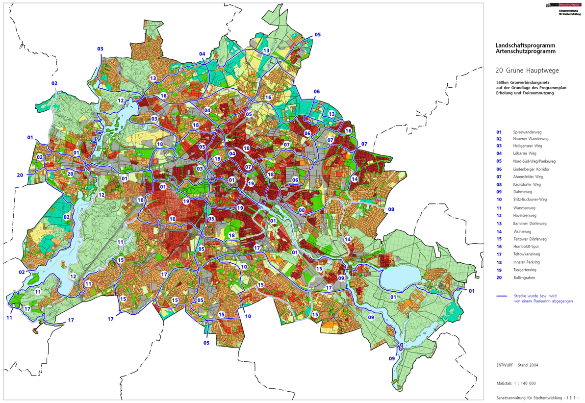
20 main green paths
20 green main paths are a compilation of 20 hiking trails through the Berlin urban area with a total length of around 550 kilometers. The aim is to link “residential areas with the diverse recreational opportunities in parks and local recreation areas in Berlin and Brandenburg ” (Senate Department for Urban Development and the Environment). The pedestrian should have the opportunity to “ experience the city intensely as a combination of culture, history and ecology ”.

history
When planning the design of Greater Berlin , Hermann Jansen proposed in 1910 considerations ("Jansen Plan") to contrast the "Stone Berlin" with the "Green Axis" with an interior and the planned "Outer Parkring". Six routes were planned through the four Berlin recreational areas at Müggelsee , Wannsee , Tegeler See and Berlin's Barnim . Due to the events of Berlin's history ( world wars , inflation , division ), a realization was only possible after German reunification . The green axis cross, further green corridors and the two rings connect the public green areas scattered in the urban space with each other and with the landscaped areas in Brandenburg. As a continuation of the Jansen Plan, these radial and tangential green corridors between the historic center of the city center , the densely built-up former suburbs and the landscape areas of regional parks that cross the city limits , such as the Barnim Nature Park , were set up with the “main green paths” .

The Berlin Senate decided in 1994 to network the green spaces and parks in the city more closely than before as part of a city-wide landscape planning . Ten years later, the A Plan for 20 Main Green Paths project was launched. With the help of 100 voluntary “ strollers ”, the Senate identified gaps in the road network that were closed by the project managers with the help of the strollers through “temporary detours”. In 2006 the geodata was digitized and was available as a hiking map. On March 20, 2006, the Senate Department for Urban Development signed a cooperation agreement with the Berlin local groups of BUND and FUSS with a network of a total of 20 ways to bring the public closer to the existing green and open spaces. A year later, the first flyer appeared on the Internet describing the Spreeweg . The connection leads from Charlottenburg Palace in the northwest of the city via around 50 sights to Rummelsburger Bucht in the southeast. He has since been expanded to the longest path and leads to a total of 59 kilometers of the Regional Park Döberitz Heath on the Nauen plate , the Berlin glacial valley and the government district and the historic center of Berlin to the Regional Park Müggel-Spree in the east. The shortest main route, seven kilometers long, runs along Bullengraben through the Spandau district .
In 2008 a publisher offered the first printed version of the hiking maps and the name was protected as a word mark . In this way, the states of Berlin and Brandenburg want to ensure that “the content and the routes correspond to the goals of the state of Berlin and the state of Brandenburg.” In 2009, on the 20th anniversary of the fall of the Berlin Wall , an information brochure, the Green Belt Berlin, was published . In the years 2010 to 2012 the Senate Administration developed the uniform marking system with which the paths are increasingly being marked by the Berlin Hiking Association and which is responsible for ongoing supervision. The location of the paths can change at short notice due to city life.
The ways
The main routes are increasingly marked and marked; they prefer to run on the sidewalks of the streets or through green areas. However, it is inevitable to connect separate parks and green spaces on city streets or to cross federal highways. Obviously, not all routes or bridges have yet been created, and replacement and bypass routes have been specified in some cases. The ideal tour is sometimes blocked by building structures that you do not want or cannot walk through, such as properties with water access, industrial areas, club and sports areas on private land. "Path godparents" from Berlin hiking clubs walk the main green paths, and the knowledge and observations gained are included in the path updates. The latest, officially agreed stand is published by the Senate Department for Urban Development and the Environment.
The names of the trails are based on the one hand on the Berlin rivers: Wannseeweg (No. 11) , Havelseenweg (No. 12) , Wuhletal-Wanderweg (No. 14) , Teltow Canalweg (No. 17) and especially the Spreeweg (No. 01) , also the Dahmeweg (No. 09) but also the Heiligenseer Weg (No. 03) on the Berlin-Spandauer Schifffahrtskanal , the North-South-Weg (No. 05) on the Panke or the Humboldt-Spur (No. 16) , that accompanies the north trench . From the city center to the city limits are the paths no.04 (Lübarser Weg) , no.06 (Lindenberger Korridor) , no.07 (Hönower Weg) , no.08 (Kaulsdorfer Weg) , no.10 (Britz-Buckower Weg) , the No. 13 (Barnimer Dörferweg) , No. 15 (Teltower Dörferweg) and No. 20 (Bullengrabenweg) are dedicated to historical considerations . There are also two circular hiking trails No. 18 (Innerer Parkring) and No. 19 (Tiergartenring) , which circumnavigate the city center more closely and further on green areas.
The individual articles on the paths linked below are intended to link information about the surroundings and history of the paths, intersecting and carrying streets and information about bridges in Berlin . The basis of the descriptions of the route is increasingly the version of the FIS hiking map as of 2014. Its representations show the recorded routes in blue and deviating ideal routes in red. Red continuous lines stand for partially accessible, but not through-going, and red-broken lines for desired, not (yet) accessible sections.
The Berlin Wall Trail , which runs around the former urban area of West Berlin , is in parts identical to the “main green paths”, but is not one of the 20 main green paths. The Wall Trail is based on the course of the Wall and is located on the post routes on eastern Berlin and Brandenburg territory, and in parts the customs routes on the Berlin urban area of the former western (better inner) side are used.
01 - Spreeweg / Berlin glacial valley

The "Spreeweg / Berliner Urstromtal" is the longest green main path at 59 kilometers. The addition to the name " Berliner Urstromtal " describes the course of the Spreeweg in the Warsaw-Berlin Urstromtal, which was formed during the last Ice Age . There are therefore hardly any heights to be overcome. From Hessenwinkel in the east to Spandau in the west, it accompanies the Spree through the city. The path leads through quiet forests on the outskirts, large industrial areas with adjoining allotment gardens, the medieval city centers of Köpenick and Spandau and the modern city and mostly near the shore. Careful planning of the government district left space to lead it through the center. The Spree flows into the Havel in Spandau, but the hiking trail leads here in the lowlands of the Spektegrünzug along the Falkenhagener Feld district to the state border to Brandenburg in the west.
02 - Spandauer Weg

The Spandauer Weg leads over a length of 31 kilometers within the Spandau district through the green areas of the Berlin state area west of the Havel. In the west and north it partially coincides with the Berlin Wall Trail and is supplemented in Hakenfelde by the Havelseenweg on the west bank of the Havel. It is interrupted as a circular route through the urban areas of Wilhelmstadt , Pichelsdorf and Weinmeisterhöhe. The main path 02 leads through the former Gatower Rieselfeld area and leads south to Kladow to the steamboat landing stage and the ferry F10 . At the district border, the hiking trail is taken up by the Wall Trail (albeit in Potsdam area) on the west bank of the Groß-Glienicker See .
03 - Heiligenseer Weg

The Heiligenseer Weg with a length of 25 kilometers begins at Marie-Elisabeth-Lüders-Steg , the pedestrian bridge at the Bundestag administration ( Paul-Löbe-Haus ), and leads initially along the Berlin-Spandau shipping canal and later to the northern city limits to Heiligensee . Through the natural landscape and the hustle and bustle of the city, the path connects the city of Berlin with the green outskirts. For example, on the only real waterfront, the Greenwich promenade on Lake Tegel through the Tegeler Forest with its old trees. In the Berlin district of Heiligensee , it leads through single-family houses with fields in between and ends at Berlin-Heiligensee train station .
04 - Lübarser Weg
The Lübarser Weg follows with a length of 13 kilometers on part of the "Green Belt Berlin" on the former strip of the Wall from the city center on Bernauer Strasse , where there are further connections to Green Main Paths on the Wall Trail, to the Berlin Barnim in Lübars . This by the time until the political changes unbetretbare Wall Trail (from border and coastal path) has since been under landscape protection provided and so barely ten roads cross these reconquered by nature open space. Hikers can stroll along the tracks of the Berlin Wall between Bernauer Strasse and the fields of Lübars in the west and Blankenfelde in the east, almost undisturbed by car traffic .
05 - north-south path
The north-south route runs 40 kilometers through Berlin, initially in the north along the Panke to where it flows into the Spree in the city center. From there it goes further south through the park at Gleisdreieck , the nature park Schöneberger Südgelände to the regional park Teltow Park. The southern border of Berlin is reached in Marienfelde . Benefiting from the opening of the park at Gleisdreieck , the route between the Yorckstrasse and Südkreuz stations leads through green spaces and paths, where the Tempelhof-Schöneberg district and the historic center are directly connected.
06 - Lindenberg corridor
The Lindenberg Corridor is 17 kilometers between the Lichtenberg residential areas and the fields of the village of Lindenberg north of Berlin. It connects new buildings on the Rummelsburger Bucht with Wartenberg northeast on the city limits through the commercially used corridor between the residential areas. Through relocations and closures, some peripheral areas of this largest commercial area in Berlin have been turned into green oases. There is the promenade on the Rummelsburg Bay, the Herzberge Landscape Park , the Falkenberger Krugwiesen and the Wartenberger Feldmark .
07 - Hönower Weg

The Hönower Weg is 21 kilometers long between the Märchenbrunnen in Volkspark Friedrichshain and the city limits of Hönow at the Hönow underground station . From the district of Prenzlauer Berg the path leads, touching Lichtenberg , through Alt-Hohenschönhausen , Marzahn and Hellersdorf .
08 - Kaulsdorfer Weg
The 18 kilometer long Kaulsdorfer Weg leads through green residential areas in Rummelsburg , Karlshorst , Friedrichsfelde, some with an urban character, some with terraced and single-family houses. Along the Biesdorfer Baggersee and through the town centers of Biesdorf and Kaulsdorf and further on the Mahlsdorf Barnimkante ( Berlin balcony ), where the view goes over this large closed settlement area, to the Kaulsdorf Baggersee and to the Müggelberge . The Kaulsdorfer Weg ends at the eastern Berlin city limits in Mahlsdorf Süd.
09 - Dahmeweg

The Dahmeweg opens up the Dahme ufer for 17 kilometers up to the confluence with the Spree. The path cannot always follow the bank, there are sometimes lake-like extensions, such as in the forest section between the Strandbad Grünau and the villa village Karolinenhof . The way finds the shore tram , which drives lonely through the forest, but also apartment buildings from the Wilhelminian era, villas, yachts and historic water sports club houses and some branch paths to the shore, the historic center of Schmöckwitz , nature to the state border and beyond.
10 - Britz-Buckower-Weg

The Britz-Buckower-Weg begins at Tempelhofer Feld and connects to the Teltowkanalweg . It runs for a total of eleven kilometers, initially along the industrial architecture north and south of the Teltow Canal , such as the Ullsteinhaus at the Tempelhof harbor . The course continues over huge allotment gardens: fruit trees, flower beds and vegetable beds determine the picture. On the way is the Britzer Garten park , which is subject to entry , but the route of the green main path circles the park and leads through the green settlement area of Buckow and Lichtenrade from Berlin to Großziethen .
11 - Wannseeweg

The Wannseeweg is a hiking route in the southwest of Berlin and connects eight lakes of the Grunewaldseenkette with the banks of the Havel over 25 kilometers . It leads from Königssee to the Berlin forest Düppel and the Potsdam park landscape almost always on wide sandy paths. It leads past the Grunewald hunting lodge , Pfaueninsel , Nikolskoe and the castles around the Glienicke Bridge . There are bathing spots and beer gardens along its course.
12 - Havelseenweg

The Havelseenweg runs for 25 kilometers along the Havel and its lakes and lies between the Großer Wannsee in the Wannsee district of the same name ( Steglitz-Zehlendorf district ) in the south and the Aalemannufer in the Spandau district, Hakenfelde district . In addition to the proximity to the banks of the Havel waters, there are the landscapes, on the one hand the plateau of the Teltow in the south and the plain of the Warsaw- Berlin glacial valley in the north . For the Teltower slope edge, the path through the Grunewald does not run directly on the banks of the Havel, but mostly on the Havelhöhenweg . To the north of the marshy Tiefwerder meadows, there are hardly any heights to overcome. In the Spandau district , the path also changes from the east side of the Havel in the south to the west side of the Havel in the north. New riverside paths have been created on the west side of the Havel waters. The waterfront industry has been relocated and new residential areas and green spaces have emerged, especially in Hakenfelde. In contrast to other green main routes, the actual route almost corresponds to the planned route.
13 - Barnimer Dörferweg
.JPG)
Through this path, districts in the north of Berlin, which formerly belonged to the Barnim villages, are connected over 31 kilometers. The main path runs between the historic village centers of Tegel , Hermsdorf , Lübars , Blankenfelde , Karow and Ahrensfelde . Part of the hiking trail also leads along the Tegeler Fließ to the Barnimer Feldmark Regional Park .
14 - Wuhletalweg
The Wuhletalweg runs 16 kilometers along the Wuhle to where it flows into the Spree. The Wuhle was a flowing water used as a sewer until the 1980s . With the expansion of the large and new housing developments in Marzahn-Hellersdorf , it and its extensive riverside areas were renatured. Now a clean stream flows next to the path in which small fish live. The northern Wuhletal was supplemented by parking spaces between the large settlements of Marzahn and Hellersdorf and is one of the green areas in the northeast of Berlin. The Wuhletalweg leads - behind the 97 meter high Kienberg - past the " Gardens of the World " park, which is subject to entry . To the south of the B 1 / B 5 federal road , however, there are spacious single-family home areas. Sometimes the green main path to the left or right of the Wuhle is signposted as the “Wuhletal hiking trail”, sometimes on both sides.
The Wuhletalweg offers along its run the following connections to public transport: from the S-Bahn station Ahrensfelde , past the S-Bahn station Wuhletal for S-Bahnhof Köpenick .
15 - Teltower Dörferweg
The Teltower Dörferweg leads over a distance of 45 kilometers on the Teltower plateau from village to village. Around 1900 it would have run between the Grunewaldseenkette and the Köpenicker Spree over rural regions made up of fields, meadows and small villages. Today the southern area of Berlin is built on and the historic village structures are hidden, as can be seen from the large arable land around Gropiusstadt that was built between 1962 and 1975 . The Teltower Dörferweg opens up the residential areas of Zehlendorf , Lichterfelde , Marienfelde , Lichtenrade , Buckow , Rudow and Adlershof between west and east . The viewing platform on the Rudower Höhe in the Rudow-Altglienicke Landscape Park offers a broad overview from east to west . The landscape park north of Adlershof, which will open up untouched meadows of the former Johannisthal airfield , is more recent and in the process of being built .
16 - Humboldt track
.JPG)
The Humboldt-Spur is a hiking and recreational trail of 34 kilometers through the Barnim from Tegelort to Tegel Castle , the residence of Alexander and Wilhelm von Humboldt , and further along the Nordgraben to the Wuhle . The north ditch was created around 1930 as a water relief ditch to the west from the Panke . To the east of the Panke, the Humboldt Trail accompanies the Fließ-, Hecht- and Seegraben on hiking trails, some of which are well developed, and connects the Wartenberg and Falkenberger Feldmark with the parkland of the Wuhletal. Between the Panke and the Wuhle, the route mostly runs away from built-up areas and through the green areas of Berlin's Barnim in the north-east of the city. The desired course has some workarounds.
17 - Teltow Canal Path

The Teltow Canal Path is 40 kilometers for the most part on the banks of the Teltow Canal between Griebnitzsee and Dahme . Some commercial areas in Tempelhof and a few objects on the canal have to be bypassed. The peculiarity of this green main path is on the one hand the proximity to the water, on the other hand the proximity to Berlin's industrial technology. The navigable canal was laid through hydrologically suitable terrain between 1900 ( groundbreaking ceremony ) and 1906 (start of operation) and flowing waters such as Lanke and Bäke were included. The Teltowkanalweg often uses the track bed of the former tow railway with which the barges were pulled by rope. According to its direction of flow, the canal is directed from east ( Berlin-Grünau ) to west (Griebnitzsee) and is thus described. Of course, the path from the Havelwasserstraße to the east can be taken, so the green part is reached first.
18 - Inner parking ring

The 50-kilometer inner park ring surrounds Berlin's inner city and connects large and small parks with green niches in the city, such as the large open space of the former Tempelhof Airport . The extensive Volkspark Wilmersdorf was created at the beginning of the 20th century in an ice age channel . The Volkspark Jungfernheide in the northwest is the second largest park in Berlin and was laid out in the 1920s on 146 hectares of forest area that stretched from the city center to Spandau. The route goes through the urban districts of Wedding , Gesundbrunnen and Prenzlauer Berg . In the east in Friedrichshain and the Kreuzberger Wrangelkiez there are cafes and restaurants on the way. The circle closes on the banks of the Landwehr Canal and the Neuköllner Schifffahrtskanal .
19 - Tiergartenring

With a length of 24 kilometers, the Tiergartenring circles the Großer Tiergarten , Berlin's largest park, and the historic center of Berlin in a narrower path than the Inner Parkring . The Tiergartenring has access to large and small parks as well as green city squares such as Volkspark Friedrichshain , Kollwitzplatz and the elongated green corridor in the canal bed of the former Luisenstadt Canal . The Spree, the Landwehr Canal and the Berlin-Spandauer Schifffahrtskanal complete the offer on the way with water access. There are the Bellevue Palace (the official residence of the President), the House of World Cultures , the Federal Chancellery , the Berlin Wall Memorial and the neoclassical gingerbread style built (Stalinist) houses the Strausberger square along the way run.
20 - Bullengrabenweg


At seven kilometers, the Bullengrabenweg is the shortest green main path. It leads over the green corridor along Bullengraben from the Berlin border near Seeburg to the right bank of the Havel south of Spandau's old town . The Bullengraben lies exclusively in the Spandau district and was only reactivated as a green corridor a few years ago and freed from the subsoil and the piping. Adjacent wastelands were completely renatured and converted into a landscape park. A new, mostly paved network of paths for walkers, cyclists and skaters leads through the Spandau district.
The route havelnah has connections to the local public transport network (Schnellbahn) in the east through the S + U-Bahnhof Spandau and the regional train station Staaken .
See also
literature
- Hiking map Berlin City. Strolling - walking - hiking . 1st edition. piekart, Berlin 2012, ISBN 978-3-935863-22-3 .
Web links
- 20 Green Main Paths , website of the Berlin Senate Department for Urban Development and the Environment, accessed on January 5, 2014.
- Overview map of the 20 hiking trails , website of the Berlin Hiking Association, accessed on January 5, 2014.
Individual evidence
- ↑ 20 Green Main Paths , website of the Berlin Senate Department for Urban Development and the Environment, accessed on January 5, 2014.
- ↑ The BUND project “20 green main paths” , BUND website, accessed on January 5, 2014.
- ↑ Ideal route network of the "20 green main routes", status: 2014
- ↑ 1910 - first overall planning with the "Jansen Plan"
- ↑ Claudia Lenk: Worth knowing about the main green paths.
- ^ Chronicle , website of the Berlin Senate Department for Urban Development and the Environment, accessed on January 5, 2014.
- ↑ Flyer “Strolling along the Stadtspree; One of 20 main green paths is inviting. ”Updated. , Press release of the Senate Department for Urban Development and the Environment from August 2, 2013, accessed on January 5, 2014.
- ↑ Trademark protection and copyright ( Memento of the original dated December 4, 2013 in the Internet Archive ) Info: The archive link was inserted automatically and has not yet been checked. Please check the original and archive link according to the instructions and then remove this notice. , Press release of the Senate Department for Urban Development and the Environment from August 16, 2008, accessed on January 5, 2014.
- ↑ Sponsorship agreement between the Berliner Wanderverband e. V. and the State of Berlin from March 15, 2010: ( PDF file, 143 kB ( Memento of the original from September 9, 2013 in the Internet Archive ) Info: The archive link has been inserted automatically and has not yet been checked. Please check the original and archive link according to instructions and then remove this note. , accessed on January 5, 2014).
- ↑ www.stadtentwicklung.berlin.de: 20 green main paths®> change notification
- ↑ a b FIS Broker map display 20 green main routes - digital hiking map , since May 2014 the recommended routes have been marked in blue, plan routes that can be walked on are red and, if they are not walkable: dashed red
- ↑ 20 main green paths: digital hiking map
- ↑ Path number: 1
- ↑ Path number: 2
- ↑ Path number: 3
- ↑ Path number: 4
- ↑ Path number: 5
- ↑ Path number: 6
- ↑ Path number: 7
- ↑ Path number: 8
- ↑ Path number: 9
- ↑ Path number: 10
- ↑ Path number: 11
- ↑ Path number: 12
- ↑ Path number: 13
- ↑ Path number: 14
- ↑ Path number: 15
- ↑ Path number: 16
- ↑ Path number: 17
- ↑ Path number: 18
- ↑ Path number: 19
- ↑ Path number: 20

01 Spreeweg | 02 Spandauer Weg | 03 Heiligenseer Weg | 04 Lübarser Weg | 05 North-South Path | 06 Lindenberg Corridor | 07 Hönower Weg | 08 Kaulsdorfer Weg | 09 Dahmeweg | 10 Britz-Buckower Weg | 11 Wannseeweg | 12 Havelseenweg | 13 Barnimer Dörferweg | 14 Wuhletal hiking trail | 15 Teltower Dörferweg | 16 Humboldt track | 17 Teltow Canal Path | 18 Inner parking ring | 19 Tiergartenring | 20 Bullengrabenweg