
Barnimer Feldmark Regional Park
The Barnimer Feldmark Regional Park stretches from northeast Berlin to the Brandenburg districts of Barnim and Märkisch-Oderland . This is how urban and rural areas are connected. In addition to nature conservation , the Barnimer Feldmark regional park serves as an instrument for regional planning for other purposes such as local recreation and economic development .
location
As the name suggests, the Barnimer Feldmark Regional Park has a share in the Barnim landscape . This is not exactly congruent with the district of Barnim, because parts of the Barnim now administratively belong to the district of Märkisch-Oderland adjoining to the south. In addition, Berlin also has a share in the Barnim, if one considers the Barnim in its capacity as a base moraine plate.
The Barnimer Feldmark Regional Park is therefore located in the Berlin “ bacon belt ”, the so-called “closer interdependence”.
In the Berlin part of the regional park , in the north-east of the German capital, the large housing estates criss-crossed by green spaces , also popularly known as prefabricated buildings or “ slabs ” for short, often form a strong contrast to the adjacent, much less built-up areas beyond the city limits.
On the Brandenburg side, the regional park extends in the east to Eggersdorf , Strausberg and Gamengrund , an ice age meltwater channel . In the north, an approximate line from Tiefensee (district of Werneuchen) to Bernau marks the boundary of the regional park. The western edge of the regional park is roughly formed by the railway line from Bernau to Berlin.
The Barnimer Feldmark Regional Park has an area of approx. 43,000 hectares .
Landscape character
The majority (over 60%) of the regional park is dominated by agriculture. The soils of the ground moraine plate are used for arable farming , partly also for cattle breeding , and around Werneuchen also for fruit growing .
To the east of the regional park in the area around Strausberg there are a few lakes, while the rest of the regional park is poor in water. In addition to the Haussee in Seefeld (near Werneuchen), there are mainly small still waters, the so-called Pfuhle, created by ice age dead ice , which correspond geomorphologically to the Söllen .
The east of the regional park is more forested than the more open west. The contiguous forests that border the regional park to the east are actually very extensive and have little human infrastructure such as roads or settlements. The Blumenthal, a large, contiguous forest area, extends well beyond the regional park.
The ground moraine landscape is wavy - mostly slightly in the west, moderately towards the east - whereby the glacial (Ice Age) gullies such as the Gamengrund are deeply cut and have steep slopes.
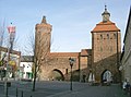
Stone gate and hunger tower in Bernau

View from the Ahrensfeld mountains to Berlin-Ahrensfelde

Retsee near Hönow
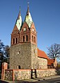
Church in Willmersdorf

.jpg)


Places in the regional park
In addition to Berlin, there are the following cities in the regional park or on its edge:
District of Märkisch-Oderland
- Altlandsberg
- Strausberg
Barnim district
- Werneuchen
- Bernau
Another bigger place is Blumberg .
In addition, numerous village villages are typical in the Barnimer Feldmark Regional Park , which have often retained their original charm with their field stone churches.
Barnimer Feldmark Regional Park V.
The association “Regionalpark Barnimer Feldmark e. V. ”was founded in 1996 and is part of the“ Umbrella Association of Regional Parks in Berlin and Brandenburg e. V. “organized.
It sees itself as a "regional communication forum" and has the following goals / projects:
- Village development
- Nature conservation and landscape management
- Employment projects
- Promotion of regional identity
- Supraregional cooperation
- public relation
The Barnimer Feldmark Regional Park Association also coordinates the marketing of regional rural products ( farm shop ), gastronomic offers and hotels, as well as other tourist offers such as riding stables .
Traffic routes to and in the regional park
Road traffic
In the southwest, the Berlin outer ring road, Autobahn 10 , crosses the regional park. At the Schwanebeck Autobahn triangle, Autobahn 11 branches off towards the north.
Another connection from Berlin to the north is Bundesstraße 2 , which also crosses Bernau.
From Berlin to the northeast, the federal highway 158 , which touches the towns of Ahrensfelde, Blumberg, Seefeld, Werneuchen and Tiefensee, leads right through the regional park.
The smaller and larger towns are connected by streets or paths, often laid out as avenues .
Rail transport
A railway line, the Wriezener Bahn , also crosses the regional park , mainly parallel to Bundesstraße 158 . It leaves the Berlin urban area at Ahrensfelde , the end point of the S7 line of the Berlin S-Bahn , and leads to Werneuchen . Until December 2014 it was used every hour by the East German Railway (ODEG) , since then the Niederbarnimer Railway has been serving the RB25 line. The route, which was subsequently closed, continues via Tiefensee to Wriezen and is used as a draisine route between Tiefensee and Sternebeck (outside the regional park).
In addition to this cross-connection, there are two railway lines on the edge.
In the south this is the Ostbahn , which runs from Berlin to Strausberg (up to there also with S-Bahn traffic [line S5]) and on to Poland ( Küstrin [Kostrzyn]). It is used by the Niederbarnimer Eisenbahn line RB26.
In the west, the Szczecin Railway runs from Berlin to Bernau and on towards Eberswalde . The Bernau station is the only stop in long-distance traffic ( Intercitys and some Eurocitys ). It is also served by the regional express line RE3.
Air traffic
Is Werneuchen the airfield ( Sonderlandeplatz ) Werneuchen ( airfield Werneuchen ) and Strausberg the airfield Strausberg ( airfield Strausberg ).
information
In addition to the Barnimer Feldmark e. V. there are decentralized information points distributed over the area of the regional park. These provide information about hiking trails and events such as the regional park festival in summer.
The regional park also provides information on the landscape, the association's projects and tourism on the Internet.
Web links
- http://www.regionalpark-barnimerfeldmark.de Homepage of the association Regionalpark Barnimer Feldmark
- http://www.regionalpark.de Homepage of the umbrella organization for regional parks in Berlin and Brandenburg