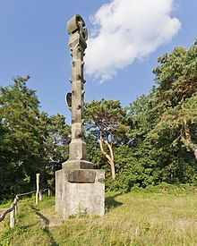
Havelhöhenweg
The Havelhöhenweg is a hiking trail in Berlin that leads from Heerstraße / Stößenseebrücke in the north along the eastern bank of the Havel to the Wannsee lido in the south. Its length is around 10 kilometers and leads past numerous excursion destinations. The path runs largely above the Havel riverside path on the western edge of the Teltow plateau . The maximum gradient to the Havelniederung (above Stößensee ) is around 35 meters. To cross former meltwater channels , the path leads down to the riverside path at various points.

history
The idea for the path originated around 100 years ago and goes back to the landscape architect Peter Joseph Lenné . The facility was built in the 1950s as part of an emergency program, but was not subsequently maintained. The Grunewald Forestry Office took over the renovation, which was partly financed by the European Union's Environmental Relief Program (UEP). In 2004, the trail was redesigned in its southern section for 870,000 euros. A 3.6 kilometer long section was made barrier-free . The Senate Department for Urban Development largely dispensed with extensive information boards along the way, but instead offers the possibility of a “virtual forest walk” on its website . All 30 knowledge points that can be seen on the route are explained.
The Havelhöhenweg is part of the 20 green main paths in Berlin as No. 12 .
Sights (selection)
(from North to south)
- Stößenseebrücke : The listed according to the plans of the civil engineer Karl Bernhard created, 174-meter-long steel - arch bridge connects Pichelsberg with the peninsula Pichelswerder .
- High bank on the Rupenhorn above the Stößensee with several listed villas and gardens. The Am Rupenhorn forest area was redeveloped by DB ProjektBau in 2009 as a replacement measure under nature conservation law for the impairment in nature and landscape caused by the construction project for the high-speed line Hanover-Berlin . The subsidiary of Deutsche Bahn designed and restored 750 meters of new and old serpentine paths and lookout points on the steep slope of the approx. 3.5 hectare area.
- Schildhorn : one around 110 meters wide and 400 meters deep headland in the conservation area Grunewald . According to the Slav prince Jaxa von Köpenick , the Schildhorn legend is said to have fled here in 1157 from Albrecht the Bear through the Havel.
- Panoramic view of the Gatow district on the west bank of the Havel in the Spandau district with Villa Lemm , a villa built in the style of English country houses by the shoe polish manufacturer Otto Lemm in 1907 and 1908 according to plans by the Berlin architect Max Werner .
- Grunewald Tower: an observation tower on the Karlsberg with an observation platform at a height of 36 m.
- Lindwerder Island : a 2.2 hectare oval island, which lies around 200 m from the east bank of the Havel between the Lieper Bay in the north and the Kleiner Steinlanke in the south.
- Panoramic view of the Kladow district in the Spandau district
- Schwanenwerder : an island built with villas and single-family houses, on which Alexander Parvus , Joseph Goebbels , Ernst Udet , Theo Morell and Axel Springer lived, among others .
- Strandbad Wannsee : The outdoor swimming pool is located on the east bank of the Großer Wannsee and has 1275 m of sandy beach and a total area of 355,000 m² (130,000 m² of which is water).
Individual evidence
- ↑ Info: Havelhöhenweg In: Berliner Morgenpost . dated May 13, 2004, accessed April 10, 2012.
- ↑ Havelhöhenweg on berlin.de, accessed on April 11, 2012.
- ↑ Claudia Fuchs: Havelhöhenweg invites you to go hiking In: Berliner Zeitung . dated May 13, 2005, accessed April 10, 2012.
- ↑ 20 green main paths®: Havelseenweg , Senate Department for Urban Development and the Environment.
- ↑ Entry in the Berlin State Monument List
- ↑ Senate Department for Urban Development Tips for trips - On Förster's Paths - In April 2009: A walk in the woods to the Rupenhorn
literature
- Manfred Reschke: Walks through Brandenburg: 50 tours through the whole country . 2nd updated and expanded edition (September 1, 2010) edition. Trescher Verlag, 2010, ISBN 978-3-89794-165-6 , pp. 297 .
Web links
- Directions for the Havelhöhenweg on berlin.de, (PDF, 755 kB), accessed on April 11, 2012.
Coordinates: 52 ° 29 ′ 29.3 " N , 13 ° 11 ′ 32.1" E


