
Lindenberg corridor
| Lindenberg corridor | |
|---|---|
 The Lindenberger Corridor has its inner-city starting point at Rummelsburger See |
|
| Data | |
| length | 17 kilometers |
| location | Berlin (green main path) |
| Supervised by |
FOOT e. V. BUND-Berlin Citizens' Project "Network" Berliner Wanderverband Stadtentwicklung |
| Markers |
 Blue field, white "6" |
| Starting point |
Rummelsburger See (north bank) 52 ° 30 ′ 3.6 ″ N , 13 ° 28 ′ 32.4 ″ E |
| Target point | Wartenberg Landscape Park (NO) 52 ° 35 ′ 26.7 ″ N , 13 ° 31 ′ 10.2 ″ E |
| Type | trail |
| Height difference | low |
| Level of difficulty | inner city way |
| season | all year round |
| particularities | Promenade on the Rummelsburg Bay, Herzberge Landscape Park, Falkenberger Krugwiesen, Wartenberger Feldmark |
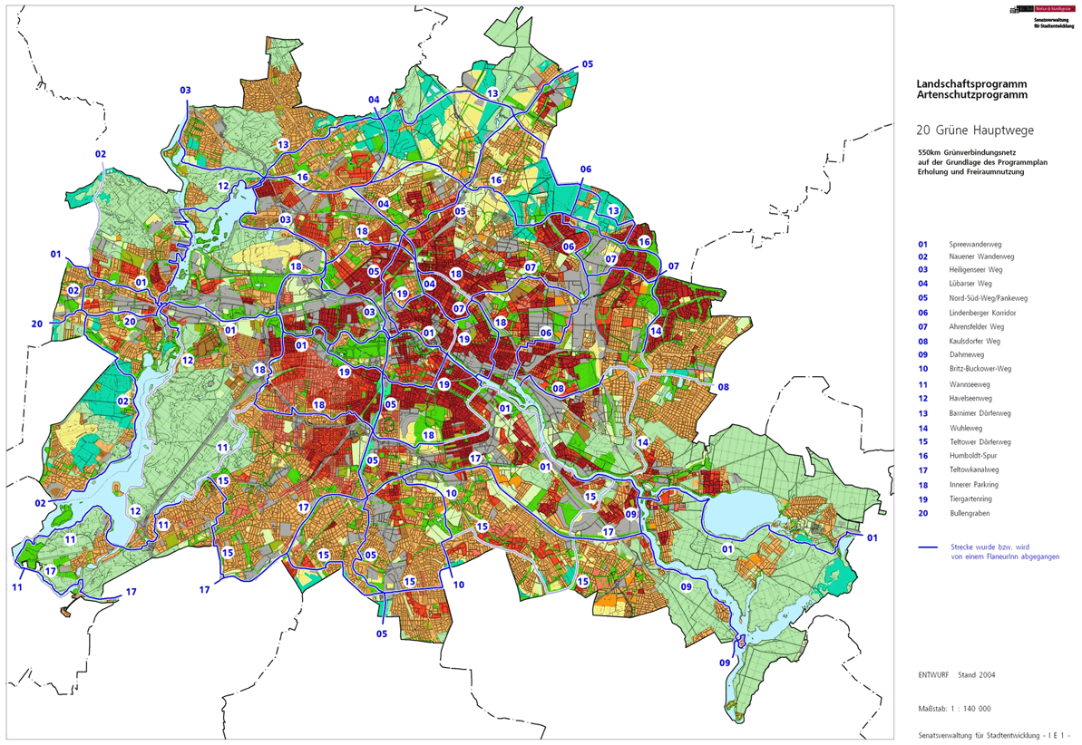
The Lindenberger Corridor is number 06, one of the 20 main green routes . This is a compilation of 20 hiking trails through the Berlin urban area with a total length of around 550 kilometers. The aim is to link “residential areas with the diverse recreational opportunities in parks and local recreation areas in Berlin and Brandenburg ” (Senate Department for Urban Development and the Environment). The pedestrian should have the opportunity to “experience the city intensely as a combination of culture, history and ecology”. The green Hauptweg 06 is between the city center and the outskirts to Lindenberg .
course
The Lindenberg Corridor is 17 kilometers between the Lichtenberg residential areas and the fields of the village of Lindenberg north of Berlin. It connects new buildings on the Rummelsburger Bucht with Wartenberg northeast on the city limits through the commercially used corridor between the residential areas. Through relocations and closures, some peripheral areas of this largest commercial area in Berlin have been turned into green oases. There is the promenade on the Rummelsburger Bucht, the Herzberge landscape park and the Falkenberger Krugwiesen and Wartenberger Feldmark .
From Rummelsburger See to Normannenstrasse
The Lindenberger Corridor begins in the city center on the north bank of the Rummelsburger See and connects to Kaulsdorfer Weg (Hauptweg 06). This entry point is on its north bank not far from the Ostkreuz S-Bahn station . It goes from the Paul-und-Paula-Ufer at the transition to the Zillepromenade. Here in the Rummelsburg district there is a high ropes course and canoe rental on the lake. A short bypass leads to the property of the main street around this facility, it ends at the main street, which is crossed to Karlshorster street, which then cross under the two S-Bahn lines (Ostkreuz – Rummelsburg and Ostkreuz – Nöldnerplatz). The path continues via Marktstrasse / Türschmittstrasse into Pfarrstrasse to the next railway bridge, in front of which one changes to the district of Lichtenberg . The Wiesenweg branches off to the left under the railway bridge, the railway line here connects the circular railway in an arc from north and south with the Lichtenberg station and the railway facilities of Rummelsburg on the Stadtbahn . In Lichtenberg you have reached the prefabricated buildings from the 1970s on Schulze-Boysen-Straße , but the hiking trail leads to the left through the green spaces between the apartment block and the railway line (Tasdorfer and Wartenbergstraße bridges on the left) to Gürtelstraße. Then you have to cross Frankfurter Allee ( B 1 / B 5 ) to Möllendorffstraße or use the underground access. The rest of the way leads into the Rathauspark and via Rathausstrasse and Rudolf-Reusch-Strasse through the (abandoned) municipal cemetery. Turn left into Ruschestrasse and then right into Normannenstrasse, bypassing the former Stasi site with today's research and memorial site.
From Lichtenberg to Hohenschönhausen
On Roedeliusplatz, in the south is the Belief Church, the path leads north to Plonzstraße. In front of the municipal cemetery, take the Gotlindestraße to the right on the Stadtstraße, over the Siegfriedstraße with tram traffic, to the height of Kriemhildstraße and from the Gotlindestraße behind the bus depot to the left between lawns and trees to the north, through the nature park to the Evang. Queen Elisabeth Herzberg Hospital. The tram line from Herzbergstrasse and the hiking trail are already officially called Allee der Kosmonauten. A green strip is reached at the Marzahn-Hohenschönhauser Grenzgraben into which the planned hiking trail turns to the left.
As there are some inaccessible sections on the hiking trail, a larger bypass is suggested, which also includes tram lines. This leads over the Grenzgrabenbrücke to the Allee der Kosmonauten , where the Marzahn district in the Marzahn-Hellersdorf district is reached on Rhinstrasse . On the northern footpath of the avenue, the S-Bahn bridge is crossed and parallel to Märkische Allee, the path leads over Helene-Weigel-Platz to Springpfuhl and west of Murtzaner Ring through the green area to Poelchaustraße, on this to the left again over Märkische Allee on the Dahmeweg behind the S-Bahn station Poelchaustraße, turn left into Frank-Schweitzer-Straße to the pedestrian underpass under Landsberger Allee. The connection to the "regular" Lindenberg corridor takes place between the railway line and the Knorr industrial park. The actual route of the corridor, however, is through the green strip at the Grenzgraben to the north and ideally continuously along the Grenzgraben via Rhinstrasse (northern Rhinstrasse Bridge) to Marzahn, Pyramidenring (Pyramidenring Bridge), via Landsberger Allee, Alt-Hohenschönhausen , Themarer Strasse (this is accessible) to Hönower Weg (Hauptweg 07) and together with it on the route of the former Tegel – Friedrichsfelde industrial line south and east around the Papenpfuhl basin , a route that is accessible, but there is no intended transition over the railway facilities.
In the Feldmark around Falkenberg
North of the industrial park on the site of the former Knorr company lies the trail on the Marzahn-Hohenschönhauser Grenzgraben through the railway line . The bypass here follows the ideal tour. Lindenberger Korridor and Hönower Weg run against the direction of flow of the trench to the north, oriented on the district heating pipe. While the Hönower Weg turns east with the border ditch, the Lindenberg Corridor leads further west of the Bitterfeld ponds to Klettwitzer Strasse. Here again a bypass takes place eastwards to Bitterfelder Straße over the intersection with Gehrenseestraße (Pablo-Picasso-Straße) and it goes to Neu-Hohenschönhausen . The ideal path remains close to the railway on fallow land. At the height of the Krugwiesen, turn right at right angles from the district heating pipe and reach the bypass at Pablo-Picasso-Straße 45. At the end of the asphalt road there is a large open space in the designated industrial area (which was not implemented after the turnaround ). The footpath leads into the LSG 'Falkenberger Krugwiesen' (past and through) southeast of the new housing estate (prefabricated buildings) of Hohenschönhausen-Ost. At the district boundary to Falkenberg , the path leads around the high-rise estate away from the residential estate and at Falkenberger Wiesengraben to the west to Falkenberger Chaussee (before it merges into Dorfstraße), on short sections you change across the district boundary. To the west of Falkenberger Chaussee, slightly to the left, the main path goes on the Falkenberger Fußsteig at the district boundary, which changes from Falkenberg to Wartenberg after a few meters, past the Rohrpfuhl.
Approach Lindenberg through Wartenberg
The Prendener Straße is crossed and on the Neubrandenburger Straße it goes again between the new building blocks from the 1970s and 1980s and the new buildings at Am Gutshof to the west. The path leads between Neu-Hohenschönhausen and Wartenberg to the “Extended Village Ditch Wartenberg”. The further path goes around the Krummen Pfuhl south to Ernst-Barlach-Straße and on the Schweriner Ring (western section) further to Wartenberg over the Hechtgraben. There you will reach the Humboldt lane , which you take to the right. After about 250 meters, the Lindenberger Korridor turns left to the north in front of Straße 10. At the eastern edge of the Wartenberg landscape park , west along the arable land, go straight to the north-northeast to the Barnim Dörferweg (main path no.13) and along with it to the east (going off to the right). The tree-lined Lindenberger Straße (corner of Straße 2) leads the trail again north to the city limits with the community of Ahrensfelde (district Lindenberg). The Berlin main path ends here. The BVG bus line 259 to Berlin-Weißensee can be reached one kilometer on Wartenberger Strasse in Lindenberg to Karl-Marx-Strasse . Alternatively, the final stop of bus 256 in the Wartenberg settlement can be reached on Hauptweg 13, Straße 2 and Birkholzer Weg . This leads to Gehrenseestrasse and ultimately to Weißensee.
Local transport connections
From the city center to the outskirts to Lindenberg , the Lindenberg corridor is accompanied by nearby public transport connections: S + U-Frankfurter Allee, S-Bahnhof Ostkreuz, S-Bahnhof Betriebsbahnhof Rummelsburg, S-Bahnhof Marzahn, S-Bahnhof Gehrenseestraße.
literature
- Hiking map Berlin City. Strolling - walking - hiking . 1st edition. piekart, Berlin 2012, ISBN 978-3-935863-22-3 .
Web links
- 20 Green Main Paths , website of the Berlin Senate Department for Urban Development and the Environment, accessed on January 5, 2014.
- Overview map of the 20 hiking trails , website of the Berlin Hiking Association, accessed on January 5, 2014.
Individual evidence
- ↑ a b path number: 6
- ↑ FUSS e. V.
- ↑ The BUND project "20 Green Main Paths"
- ↑ Project "20 Green Main Paths® in Berlin"
- ^ Association for hiking in the LSB Berlin
- ↑ Senate Department for Urban Development and the Environment , Unit IE Nature Conservation, Landscape Planning and Forestry
- ↑ Chronicle of the 20 green main routes on berlin.de
- ↑ 20 main green paths. In: Website of the Berlin Senate Department for Urban Development and the Environment. Retrieved January 31, 2017 .
- ↑ The BUND project “20 main green paths”. In: BUND website . Retrieved January 31, 2017 .

01 Spreeweg | 02 Spandauer Weg | 03 Heiligenseer Weg | 04 Lübarser Weg | 05 North-South Path | 06 Lindenberg Corridor | 07 Hönower Weg | 08 Kaulsdorfer Weg | 09 Dahmeweg | 10 Britz-Buckower Weg | 11 Wannseeweg | 12 Havelseenweg | 13 Barnimer Dörferweg | 14 Wuhletal hiking trail | 15 Teltower Dörferweg | 16 Humboldt track | 17 Teltow Canal Path | 18 Inner parking ring | 19 Tiergartenring | 20 Bullengrabenweg