
Kaulsdorfer Weg
| Kaulsdorfer Weg | |
|---|---|
 Berlin balcony , view of the eastern slope |
|
| Data | |
| length | 17 kilometers |
| location | Berlin (green main path) |
| Supervised by |
FOOT e. V. BUND-Berlin Citizens' Project "Network" Berliner Wanderverband Stadtentwicklung |
| Markers |
 Blue field, white "8" |
| Starting point |
Treptower Park 52 ° 29 ′ 38.9 ″ N , 13 ° 27 ′ 47 ″ E |
| Target point |
Rahnsdorfer Strasse 52 ° 29 ′ 34.6 ″ N , 13 ° 37 ′ 46.6 ″ E |
| Type | trail |
| Height difference | low |
| Level of difficulty | inner city way |
| season | all year round |
| Viewpoints | Berlin balcony |
| particularities | Through green settlement areas from urban areas to those with a settlement character and through the old settlement centers in the east of Berlin. |
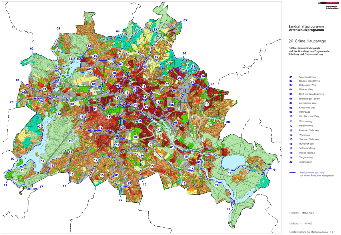
The Kaulsdorfer Weg , number 08, is one of the 20 main green routes . This is a compilation of 20 hiking trails through the Berlin urban area with a total length of around 550 kilometers. The aim is to link “residential areas with the diverse recreational opportunities in parks and local recreation areas in Berlin and Brandenburg ” (Senate Department for Urban Development and the Environment). The pedestrian should have the opportunity to “experience the city intensely as a combination of culture, history and ecology”.
course
The 18 kilometer long Kaulsdorfer Weg leads through green settlement areas in Rummelsburg, Karlshorst, Friedrichsfelde partly with urban character, partly with terraced and single-family houses. Along the Biesdorfer Baggersee and through the town centers of Biesdorf and Kaulsdorf and further on the Mahlsdorf Barnimkante ( Berlin balcony ), where the view goes over this large closed settlement area, to the Kaulsdorf Baggersee and to the Müggelberge. The Kaulsdorfer Weg ends at the eastern Berlin city limits in Mahlsdorf Süd.
Alt-Treptow
The beginning of the Kaulsdorfer Weg in the Alt-Treptow district is in Treptower Park on the southern bank of the Spree . There is a connection to the Spreeweg and the E11 long-distance hiking trail . This location near the Treptow landing stage is easily accessible from the Treptower Park S-Bahn station ( Ringbahn and Görlitzer Bahn ). While route E11 remains under the Elsenbrücke on the south bank of the Spree, Kaulsdorfer and Spreeweg walk together over the Parkwegbrücke next to the Oberspree ring railway bridge to the north bank of the Spree. The two main routes leave the district and the Treptow-Köpenick district as you cross the south bank of the Spree .
Friedrichshain
On the Parkwegbrücke over the Spree the change takes place in the district Friedrichshain , district Friedrichshain-Kreuzberg . The green Hauptweg 01 (Spreeweg) and the Hauptweg 08 (Kaulsdorfer Weg) lead along the bridge ramp between the railway line and the green area to the Alt-Stralau street at the corner of Kynaststraße. The Spreeweg goes left (westwards) to Stralauer Allee , while the Kaulsdorfer Weg turns right onto the Stralau peninsula at Dora-Benjamin-Park. On the Stralauer peninsular is a continuous Ufergrünzug the southeastern tip of the island park, at the end of the tunnel road with former Spreetunnel . However, the green Hauptweg 08 uses the Glasbläserallee on the edge of the new Stralau buildings , which leads through the grounds of the demolished Stralau glass works . At the end of the street you reach the Rummelsburger See and the shore path leads around the (also known as) Rummelsburger Bucht to the left to the west bank. After 80 meters of park path on the lakeshore, you will reach the Friedrichshain suburbs.
Rummelsburg
When you cross from Friedrichshain to Rummelsburg ( Lichtenberg district ), the riverside path is named Paul-und-Paula-Ufer and continues to the north bank. Before the start of the development ("Quartier Rummelsburg 1"), the Lindenberger Korridor (Hauptweg 06) goes north, the riverside path is now called the Zillepromenade and around a daycare center you reach Emma- Ihr -Straße , which leads to the left from the bank . Passing the streets An den Knabenhaeuser , An der Bucht and Vicki-Baum-Straße , you can reach it via the Rummelsburger Hauptstraße . The main street is crossed at the traffic light crossing into Schlichtallee and through two railway bridges (five-track for the Frankfurt Railway and two-track connection to the Ringbahn ) and a subsequent pipe bridge (district heating line from the Klingenberg power plant ). Zobtener Straße goes off between the railway bridges and the KGA 'Paradies II' is located. The Max-Taut-Schule (OSZ) is located on the right of the street, around it and then to the right into Fischerstraße . On the left behind the sports field and recycling yard there is the block park, a green corridor at the KGA 'Sanssouci', on the right of the street there are other school buildings. On the Fischerstraße you can reach the Zobtener Straße and the railway line from Rummelsburg. On the Zobtener Straße, 10 zone and road damage, the Rummelsburg depot is reached between the railway line and the suburb of Friedrichsfelde . Past the train station to the left, it goes diagonally into Hönower Weg and with the beginning of the railway farming allotments at the branching off Bahngles to the Biesdorfer Kreuz to the right of the path, you leave Rummelsburg.
Friedrichsfelde
The Friedrichsfelde district is reached on the Hönower Weg . To the left of the path is the dog park, which is used diagonally to the left on the park path around the sports field. At the parking lot and over the one on Dolgenseestrasse , Kaulsdorfer Weg goes through the green corridor between the apartment blocks (Mellenseestrasse and Sewanstrasse), built in the 1960s as the Hans-Loch district , and the VnK route . At the end of Hönower Weg at the level of Friedenhorster Strasse , the railway underpass is used to the right to the allotment gardens, which are already outside Friedrichsfelde.
Karlshorst
With the change of sides on the embankment to Karlshorst through the underpass to the garden path of the KGA 'Frühauf' and 'Gute Hoffnung', the main path goes to the left and then past the HTW campus Treskowallee to Treskowallee . Next to the bridge this is crossed into Richard-Kolkwitz-Weg and further along the Kleinhaussiedlung ( Seifert- , Breckow- , Hortenweg ). Here the underground line to Hönow changes under the VnK line to the southern side, so from the height of Ursula-Goetze-Straße past the de-dedicated areas in the north of the cemeteries of the Evangelical parishes of Friedrichsfelde and Karlhorst, the border to Friedrichsfelde goes unnoticed via Kaulsdorfer Weg (here continue Richard-Kolkwitz-Weg) to the end of the cemetery area on the right. Behind the Zwieseler Straße there is an area strip that is kept free for the planned east bypass, but 80 meters after the Zwieseler Straße the Richard-Kolkwitz-Weg and the district end.
Biesdorf
With the Biesdorf district , the Kaulsdorfer Weg changes from the Lichtenberg district to Marzahn-Hellersdorf. Over the route of the Osttangente the further route leads through the underpass of a demolished railway line and the double-track railway bridge from the Biesdorfer Kreuz to the south. Rägeliner goes to the right and Schackelster Strasse to the left . Then Beruner Straße turns left and goes through the underpass at the Biesdorf-Süd underground station . Passing KGA 'permanent gardens' and over Debenzer Straße at KGA 'Klein Biesdorf Süd', at the end of the street, the west bank of the Biesdorfer Baggersee and its north bank following to Baggerseestraße is walked on. Here it goes north on the Gladauer Weg , at the railway bridge the Weißenhöher Straße to the right and at the next intersection the trench jump to the left.
When you cross Alt-Biesdorf ( B 1 / B 5 ) at the traffic lights with two separate lanes, you will find yourself on Oberfeldstrasse opposite. The historic Biesdorf Church is on the right on the median. The first street on the right ( Parkweg ) leads to the Biesdorf Castle Park. From the park entrance on Albert-Broderson-Allee (opposite Schloss Biesdorf ) to the left and in the north of the park a park path at the Parktheater to the right (eastwards) to the exit at Blumberger Damm / Frankenholzer Weg . The Blumberger Damm crosses diagonally to the right to the parking lot of the Theater am Park and through the green area to the commercial space on Walsheimer Straße in front of the underground line . The planned passage at the level of the property at Walsheimer Straße 48 and the double-track subway is missing, so the Walsheimer Straße to the south is used as an alternative and the Alt-Biesdorf subway bridge is used. Immediately after the bridge, the Biesdorfer Friedhofsweg leads to the left past the "Wuhletal Landscape Park" (initially partly fallow land, then Biesdorf Municipal Cemetery) to the north along the subway. In front of the S- / U-Bahnhof Wuhletal , the Wuhletalweg (Hauptweg 14) comes from the south on the course of the Hauptweg 08. On the waterway bridge, both main paths cross the Wuhle, on the east bank of which the district is left.
Kaulsdorf
Kaulsdorf is reached via the waterway bridge after the Wuhle . The Wuhletalweg continues to the north through the S and U-Bahn station on the Wuhle, the Kaulsdorfer Weg turns south and south around the Kaulsdorf cemetery, which is located on the suburb of Hellersdorf. The village road is reached at the northern end through a field and green area . This street past Zernsdorfer Straße , Kaulsdorfer Weg on Dorfstraße Höhe Brodauer Straße reaches the historic Kaulsdorfer Jesus Church on a triangular green area. Past the Dorfkrug from 1800 and the New Apostolic Church, the Dorfstrasse again reaches the Bundesstrasse along the old trade and military route and part of Reichsstrasse 1 from Aachen via Berlin to Königsberg (today: B1 / B5). In the district called Alt-Kaulsdorf , this street is crossed into Chemnitzer Straße by traffic lights . Kaulsdorfer Weg turns left at the first cross street in Am Niederfeld . There is initially commercial space on the left and the Kaulsdorf-Süd settlement area on the right. In this settlement area to the right the Windhorststrasse , Reetzer , Königshütter , Penkuner We , Lassaner Strasse to the latter two to the left at Am Feldberg and Steffenshagener Strasse, which also lead through settlements to Alt-Kaulsdorf. Then Am Niederfeld leads through grassland, on the right the LSG Butzer See, to the left the Rosenhagener Straße then the LSG on both sides. On the Alt-Kaulsdorf road to the north is the Barnim slope, on which there are also agricultural areas. Leave the district at the Am Niederfeld intersection before Kresseweg .
Mahlsdorf
From the street Am Niederfeld it goes over the Kresseweg into the district Mahlsdorf . The Kaulsdorfer Weg leads a few steps into Elsenstraße and then diagonally left uphill north of the Elsengrund settlement and from Elsensee on a footpath through the LSG 'Barnimer Hang'. The viewpoint ' Berlin Balcony ' ( 42 m above sea level ) is reached here at the former post mill . The path continues down the slope to the ' Freie Schule Elsenstraße '. Between this and the Alba- Reclinghof on the left, the path continues on the green corridor to Gutspark Mahlsdorf with the Wilhelminian-style museum . The main route passes on the northern edge of the manor parks for Hultschiner dam, on the tram line 62 to the S-Bahn station Mahlsdorf and S-Bahn station Köpenick drives. The green main path to the right leads again to Elsenstraße at the end of the estate park. Past the Elsenteich, the path leads to the confluence of Rosa-Valetti-Strasse over the tram tracks and Hultschiner Damm into Rahnsdorfer Strasse . This road with bus traffic is bypassed by using the settlement roads. Turn left into Röbeler Weg , right into Karlstrasse , past the exiting Theodorstrasse and Heribaldstrasse over the crossing Pilgramer Strasse and at the end right into Hochwieser Strasse . Once you have reached Rahnsdorfer Straße, Kaulsdorfer Weg turns left to Zipser Weg . Here, 100 meters further on, the left side of the street with the cemetery belongs to Hoppegarten with an entrance from the Berlin area. The green main path ends at the city limits to Hoppegarten (Heidemühle), where the road continues as a cemetery road through the Dahlwitzer Forest as a Brandenburg hiking trail. A return trip to Lichtenberg is possible at the Nesselgrund bus stop on Dahlwitzer Straße . There is also a connection to the European long-distance hiking trail E11 in the Dahlwitzer Forest . This takes you through the Berlin urban forest in Erpetal Friedrichshagen and there the Friedrichshagen S-Bahn station ; from the end of Kaulsdorfer Weg it is 4.6 kilometers to the S-Bahn station.
Local transport connections
The following public transport connections are located on Kaulsdorfer Weg from the city center: across Rummelsburger Bucht, Treptower Park S-Bahn station, followed by Ostkreuz S-Bahn station and Betriebsbahnhof Rummelsburg S-Bahn station; to the north there are accesses to the Biesdorf underground station Süd and the S + U-Bahnhof Wuhletal possible.
literature
- Hiking map Berlin City. Strolling - walking - hiking . 1st edition. piekart, Berlin 2012, ISBN 978-3-935863-22-3 .
- Hiking map: Am Barnimhang (Biesdorf-Kaulsdorf-Mahlsdorf) with illustrations, also as a flyer at the Marzahn-Hellersdorf district office ( Memento from July 30, 2014 in the Internet Archive )
Web links
- 20 Green Main Paths , website of the Berlin Senate Department for Urban Development and the Environment, accessed on January 5, 2014.
- Overview map of the 20 hiking trails , website of the Berlin Hiking Association, accessed on January 5, 2014.
Individual evidence
- ↑ a b c Path number: 8
- ↑ FUSS e. V.
- ↑ The BUND project "20 Green Main Paths"
- ↑ Project "20 Green Main Paths® in Berlin"
- ^ Association for hiking in the LSB Berlin
- ↑ Senate Department for Urban Development and the Environment , Unit IE Nature Conservation, Landscape Planning and Forestry
- ↑ Chronicle of the 20 green main routes on berlin.de
- ↑ 20 main green paths. In: Website of the Berlin Senate Department for Urban Development and the Environment. Retrieved January 31, 2017 .
- ↑ The BUND project “20 main green paths”. In: BUND website . Retrieved January 31, 2017 .
- ↑ 108 S + U Lichtenberg - Waldesruh, Mahlsdorfer Allee

01 Spreeweg | 02 Spandauer Weg | 03 Heiligenseer Weg | 04 Lübarser Weg | 05 North-South Path | 06 Lindenberg Corridor | 07 Hönower Weg | 08 Kaulsdorfer Weg | 09 Dahmeweg | 10 Britz-Buckower Weg | 11 Wannseeweg | 12 Havelseenweg | 13 Barnimer Dörferweg | 14 Wuhletal hiking trail | 15 Teltower Dörferweg | 16 Humboldt track | 17 Teltow Canal Path | 18 Inner parking ring | 19 Tiergartenring | 20 Bullengrabenweg