
Bullengrabenweg
| Bullengrabenweg | |
|---|---|
 Wet meadow at Bullengraben in Staaken |
|
| Data | |
| length | 7 kilometers |
| location |
Spandau green main path |
| Supervised by |
FOOT e. V. BUND-Berlin Citizens' Project "Network" Berliner Wanderverband Stadtentwicklung |
| Markers |
 Blue field, white "20" |
| Starting point | Hahneberg settlement / city limits 52 ° 31 ′ 45.8 ″ N , 13 ° 11 ′ 58.1 ″ E |
| Target point | Havelufer / Mouth of Bullengraben 52 ° 31 ′ 36.6 ″ N , 13 ° 7 ′ 41.8 ″ E |
| Type | trail |
| Height difference | 3 m |
| The highest point | 34.0 meters ( location ) |
| Lowest point | 31.3 meters ( location ) |
| Level of difficulty | inner city way |
| season | all year round |
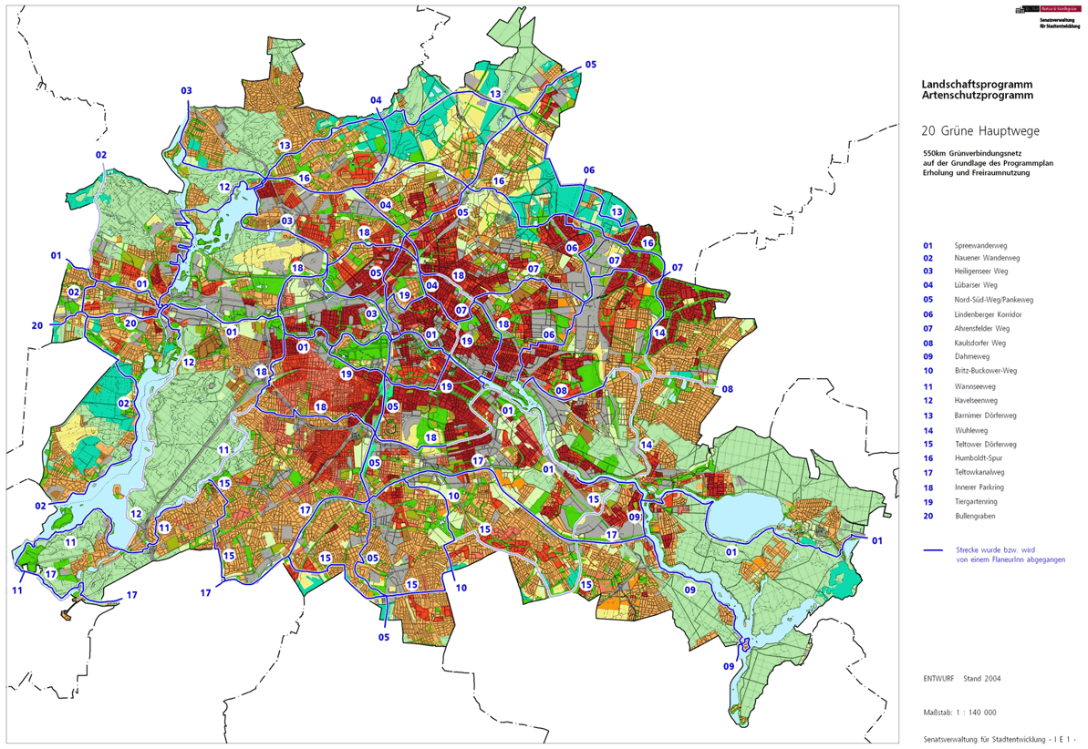
The Bullengrabenweg is with the number 20 in the Bull grave lowland one of the 20 main routes green . This is a compilation of 20 hiking trails through the Berlin urban area with a total length of around 550 kilometers. The aim is to link “residential areas with the diverse recreational opportunities in parks and local recreation areas in Berlin and Brandenburg ” (Senate Department for Urban Development and the Environment). The pedestrian should have the opportunity to “experience the city intensely as a combination of culture, history and ecology”.
course
At seven kilometers, the Bullengrabenweg is the shortest of the green main routes. It leads over the green corridor at Bullengraben along the Berlin state border near Seeburg to the confluence on the right bank of the Havel south of Spandau's old town . The Bullengraben lies exclusively in the Spandau district and was only reactivated as a green corridor a few years ago and freed from the subsoil and the piping. Adjacent wastelands were completely renatured and converted into a landscape park. Now a new, mostly paved network of paths for walkers, cyclists and skaters leads through the Spandau district.
Staaken
The Bullengrabenweg starts on the landside at the transition from Staakener Weg ( Dallgow-Döberitz ) over the Berlin city limits to Fahrlander Weg . The main path begins between a forest area (left) and the Hahneberg settlement (right). The valley path connects from this settlement from the right. The settlement is interspersed with forest area and the Staaken cemetery is located here. Then comes Döberitzer Weg from the left , on which Heerstraße ( B 5 ) must be crossed after 70 meters . Here you will find New Jerusalem out of town (to the west) . Heerstraße itself is the old connection on which the Berlin garrison moved to the Döberitzer Heide for exercises . Next to Heerstraße, the first step is on the sidewalk towards Berlin to Buschower Weg . With this street, the green Hauptweg 20 changes over the federal street to Nennhauser Damm , which is crossed at the corner of Döberitzer Straße on the pedestrian crossing (slightly to the left) .

The short street continues to Schulstraße . The Staaken airport area was located in the northwest of the green area and the area came to be known as West Staaken in the GDR area ( Nauen district ) as a result of an area swap between the Allies . On Schulstrasse, turn right through the green area opposite to the residential estate on Gummiweg . To the west of the path in the green area is now the Bullengraben. The Bullengrabenweg continues over the western end of the main road to the Philipp-Gerlach-Weg . Furthermore, through the no longer existing wall strip, West Staaken is left and the Bullengraben green belt is reached. The Bullengraben itself is here on the southern edge of the green corridor. In the north is the Staakener Mühlenviertel, a residential complex built around 2000 with multi-storey terraced houses.
From the north, the green main path 2 ( Spandauer Weg ) reaches Bullengrabenweg and connects to Staaken regional train station, 500 meters away . The place is located at the southeast corner of the Nennhauser / Brunsbüttler Damm junction and both main paths take their route together, initially southwards past a few houses to Bullengraben and follow through the Stieglake . After 250 meters, Spandauer Weg turns right again to Bergstrasse , and Hauptweg 20 remains at Bullengraben and goes to the Stieglakebecken, where the Stieglakegraben joins from the north . The further path runs, partly alternating over the Bullengraben, in the green belt of the Bullengrabenniederung, which is now called Pietzkutenlake . The Amalienhofgraben flows from the south . The Magistratsweg is reached and crossed at the eastern edge . The meadow basin follows on the left ; The Kerrweg is parallel on the right , from which Blankenstein- , Eduard-Bernstein- and Baluschekweg lead south through the settlement. The latter is followed on the right by a tree-lined green area to the Egelpfuhlgraben (from the south) and the Neustaakener Graben (from the north). However, both trenches are already in the Spandau district , the Egelpfuhlgraben after 40 meters in Wilhelmstadt .
Spandau and Wilhelmstadt

With the inflow of Egelpfuhl- and Neustaakener Graben , Bullengraben, the green corridor and also the Bullengrabenweg are located in Spandau, the core area of the Spandau district. After 160 meters the Egelpfuhlstrasse is crossed. A fallow area on the Bullegraben is bypassed on its sidewalk to the right and at the same time the green main path reaches the south bank of the Bullengraben, as this delimits the allotment gardens 'Cyclamen' and 'Freie Scholle' on the north bank. The further path through the Bullengrabengrünzug, bounded to the south by Lazarusstrasse , leads past the Ulriken basin . Its name is derived from Ulrikenstrasse in Wilhelmstadt . Before Päwesiner Weg , the KGA colony 'An der Lazarusstraße' is on the right. The narrow (seven meters wide) Päwesiner Weg only imperceptibly divides the Bullengrabengrünzug, in which the main path continues. The green corridor is here partially narrowed to 30 meters and the district boundary to Wilhelmstadt lies hard along its southern edge. Across the ditch is the Päwesiner pond and further the KGA 'Brunsbütteler Damm' and 'Wilhelmsgarten West', the weekend settlement 'Blanker Spaten', the colony 'Altonaer Straße', as well as the KGA 'Am Grünhofer Weg' and 'Wilhelmsgarten'. Thereby, between the last two, you switch to the north side of the bull pit.
The Bullengraben flows through Elsflether Weg in a large pipe, and there is a ramp at street level. The Bullengrabengrünzug continues beyond the street and the ideal route of the main path is still passable for 100 meters. However, there follows a non-accessible construction area on which the plan path is interrupted. The Bullengrabenweg route therefore runs along the Elsflether Weg at the Wilhelmstadt border to the right, along the building to Seeburger Strasse, and then using the northern sidewalk to the left on the Wilhelmstadt site. Seeburger Straße has two lanes and is parked on both sides. It ends at Wilhelmstrasse , since the suburbs here lead over this street to the Ziegelhof , which continues in Spandau as Klosterstrasse . The pedestrian crossing with traffic lights on the Wilhelmstadt side is recommended to cross this 50-meter-wide Category III main street with sidewalks, cycle paths , bus lanes , a total of five lanes and a planted median . Then turn left past the Ziegelhof into Klosterstrasse. From this it finally goes right into the last 250 meters of the (here) 40 meter wide green corridor at Bullengraben. The next green main path 12, the Havelseenweg has its confluence with the Havel . The Havelseenweg along the banks of the Havel offers access to the long-distance, regional and S-Bahn station Spandau for another 480 meters as a green main path to the north .
Local transport connections
The route has connections to the public transport - Schnellbahn network in the east through the S + U-Bahnhof Spandau and the regional train station Staaken .
literature
- Hiking map Berlin City. Strolling - walking - hiking . 1st edition. piekart, Berlin 2012, ISBN 978-3-935863-22-3 .
Web links
- 20 Green Main Paths , website of the Berlin Senate Department for Urban Development and the Environment, accessed on January 5, 2014.
- Overview map of the 20 hiking trails , website of the Berlin Hiking Association, accessed on January 5, 2014.
Individual evidence
- ↑ a b path number: 20
- ↑ FUSS e. V.
- ↑ The BUND project "20 Green Main Paths"
- ↑ Project "20 Green Main Paths® in Berlin"
- ^ Association for hiking in the LSB Berlin
- ↑ Senate Department for Urban Development and the Environment , Unit IE Nature Conservation, Landscape Planning and Forestry
- ↑ Chronicle of the 20 green main routes on berlin.de
- ↑ 20 main green paths. In: Website of the Berlin Senate Department for Urban Development and the Environment. Retrieved January 31, 2017 .
- ↑ The BUND project “20 main green paths”. In: BUND website . Retrieved January 31, 2017 .
- ↑ Large Berlin city map . Verlag Richard Schwarz Nachf .: Spandau around 1961 ( page no longer available , search in web archives ) Info: The link was automatically marked as defective. Please check the link according to the instructions and then remove this notice.

01 Spreeweg | 02 Spandauer Weg | 03 Heiligenseer Weg | 04 Lübarser Weg | 05 North-South Path | 06 Lindenberg Corridor | 07 Hönower Weg | 08 Kaulsdorfer Weg | 09 Dahmeweg | 10 Britz-Buckower Weg | 11 Wannseeweg | 12 Havelseenweg | 13 Barnimer Dörferweg | 14 Wuhletal hiking trail | 15 Teltower Dörferweg | 16 Humboldt track | 17 Teltow Canal Path | 18 Inner parking ring | 19 Tiergartenring | 20 Bullengrabenweg