
Tiergartenring
| Tiergartenring | |
|---|---|
 Aerial view of the eponymous "Tiergarten" |
|
| Data | |
| length | 24 kilometers |
| location | Berlin (green main path) |
| Supervised by |
FOOT e. V. BUND-Berlin Citizens' Project “Network” Berliner Wanderverband / Berliner Wanderclub Stadtentwicklung |
| Markers |
 Blue field, white "19" |
| Start / finish point | Park at the Nordbahnhof (Liesenstrasse) 52 ° 32 ′ 24.8 ″ N , 13 ° 22 ′ 47.2 ″ E |
| Type | Circular hiking trail |
| Height difference | 0 m |
| season | all year round |
| particularities | The Ringweg connects inner-city green spaces and parks in the center of Berlin |
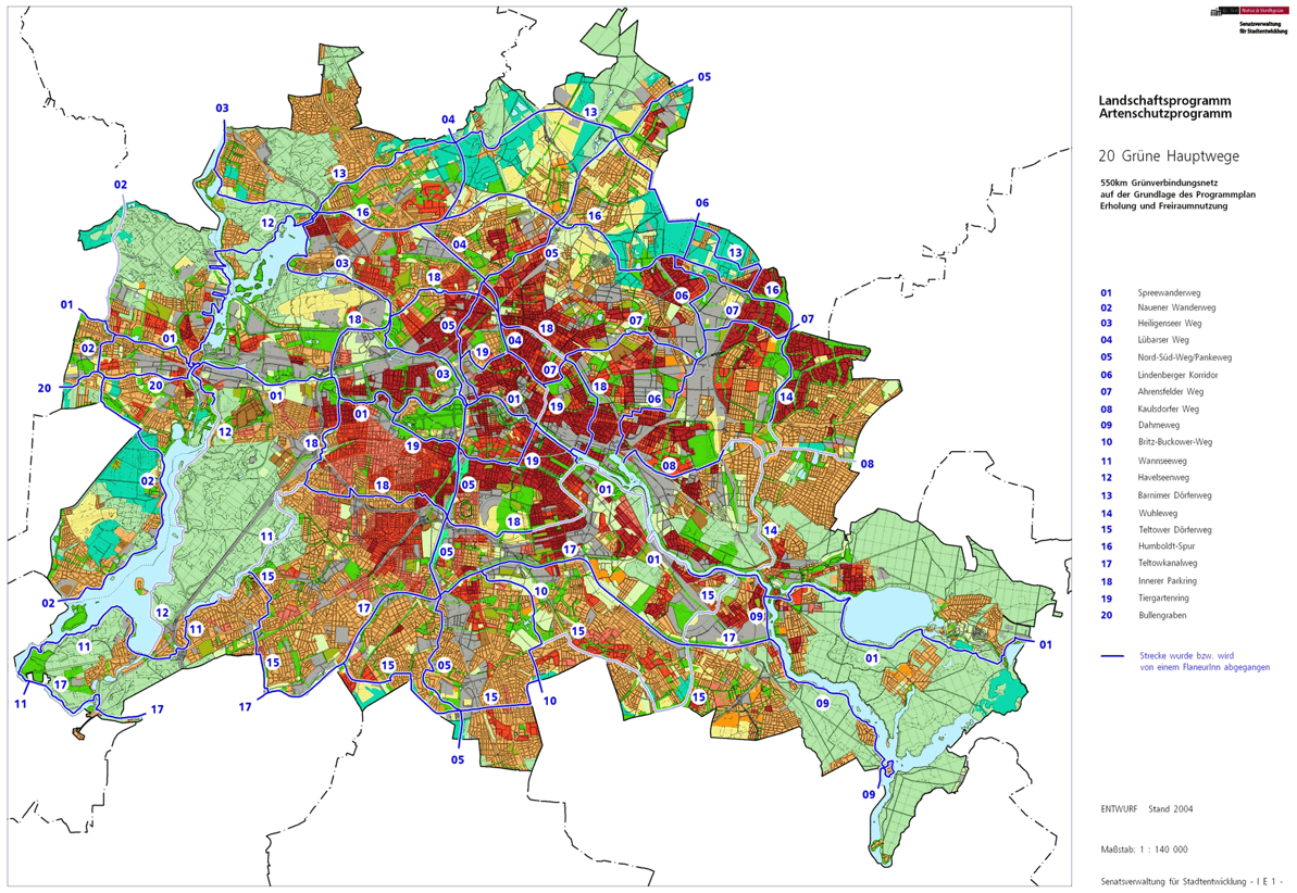
The Tiergartenring , number 19, is one of the 20 main green routes . This is a compilation of 20 hiking trails through the Berlin urban area with a total length of around 550 kilometers. The aim is to link “residential areas with the diverse recreational opportunities in parks and local recreation areas in Berlin and Brandenburg ” (Senate Department for Urban Development and the Environment). The pedestrian should have the opportunity to “experience the city intensely as a combination of culture, history and ecology”.
course
With a length of 24 kilometers, the Tiergartenring circles the Großer Tiergarten , Berlin's largest park, and the historic center of Berlin in a narrower path than the Inner Parkring. However, the Tiergartenring also has access to large and small parks and green city squares such as Volkspark Friedrichshain , Kollwitzplatz and the elongated green corridor in the canal bed of the former Luisenstadt Canal . The Spree, the Landwehr Canal and the Berlin-Spandauer Schifffahrtskanal complete the offer along the way with water access, as well as Bellevue Palace (the official seat of the Federal President), the House of World Cultures , the Federal Chancellery , the Berlin Wall Memorial and the neoclassical confectioner style (from the Stalin era) ) built houses on Strausberger Platz .
Two entry points are recommended for the Ringweg. In the north, the park at the Nordbahnhof (former Stettiner Bahnhof) on the corner of Liesenstrasse and Gartenstrasse is recommended. ( Location ) This point can be reached with the S-Bahn lines S1, S2, S25 from the S-Bahn station Humboldthain or from the Nordbahnhof . In the south, the beginning is at Böckler-Park / Landwehrkanal ( location ), this area can be easily reached from the underground lines U1 and U8 at the Kottbusser Tor underground station .
The Tiergartenring is described clockwise below. According to the FIS broker card, it has a northern entry point under the old railway bridges at the unnamed round square with a central green area, where Gartenstrasse and Liesenstrasse / Scheringstrasse intersect in the Gesundbrunnen district . A southern entry point is on the Landwehr Canal, opposite the Urbanhafen , in the Böcklerpark .
Healthy well

The Berlin Wall Trail , which is on the same line, refers to the special situation of the northern entry point into the Tiergartenring while the Wall stood here from 1961 to 1990. From this place the main path leads along the S-Bahn route of the north-south railway to the southeast into Gartenstraße along the boundary wall of the former site of the Szczecin train station .
center
After a few meters there is the opportunity to cross this wall: it is the former boundary of the area of the Szczecin train station and became the "state border" through the division of the city . The Tiergartenring leads here into the park at the Nordbahnhof to change to the Mitte district . The accompanying S-Bahn line continues next door as a tunnel. The park ends on Julie-Wolfthorn-Strasse at the Nordbahnhof (the former station was the Szczecin station). The Tiergartenring bypasses the intersection of Gartenstrasse and Bernauer Strasse in the north and leads through Gesundbrunnen again. He turns left into Bernauer Strasse on its southeastern byway, whose importance during the division of the city is the "Berlin Wall Documentation Center". However, the main path itself uses the green area south of Bernauer Straße, on the edge of Sophien-Kirchhof I and St. Elisabeth-Kirchhof I, which is crossed by Berg- , Acker- and Strelitzer Straße . The course of the route remains in the middle and across Brunnenstrasse , where the Bernauer Strasse underground station is easily accessible. By using the land on Bernauer Straße, the main path continues to Ruppiner Straße over the footpath of Brunnenstraße on the district boundary of Mitte / Gesundbrunnen. We continue on the green strip of Bernauer Strasse, crossing Swinemünder and Wolliner Strasse . Leave the district at the intersection of Bernauer / Eberswalder Strasse and the Schwedter Strasse , which branches off from both of them, south of Mauerpark .
Prenzlauer Berg

The street square from Brunnen- to Eberswalder Straße with the outgoing Schwedter and Oderberger Straße is completely in Prenzlauer Berg . This is where the Lübarser Weg (main route 04) begins , which, together with the other Mauerweg , leads north through the Mauerpark. The Tiergartenring continues through Oderberger Straße over Kastanienallee , past the Stadtbad and at the corner of Choriner Straße (a bicycle street ) over Schönhauser Allee ( B 96a ) into Sredzkistraße . From this at the corner of Knaackstraße to the right you will reach Kollwitzplatz with its green spaces. Then right to connect to the following in place of the Jews gear, Jewish Cemetery Schoenhauser Allee . The square is left on Knaackstrasse, along the tree-lined Kollwitzstrasse , past the synagogue behind Knaackstrasse 26–32. Continue to the right into Diedenhofer Strasse, go around the green area at the water tower, turn right to Belforter Strasse , past Straßburger (right) and Kolmarer Strasse (left), walk onto Prenzlauer Allee ( B 109 ) into Heinrich-Roller-Strasse . On the right are the cemeteries of the St. Marien-Nikolai and St. Georgen parishes and on the left is Winsstraße , followed by Greifswalder Straße (B 2), which is still used to the right as a crossroads. This is crossed and the Am Friedrichshain leading to the left is taken and crossed to the park entrance, leaving the district.
Friedrichshain

.jpg)
The Tiergartenring leads to the Volkspark , which gives the district Friedrichshain its name, with the fairy tale fountain . Here at the park entrance, the Hönower Weg (green main path 07) also begins around the Märchenbrunnen and then in the park to the northeast. The Tiergartenring separates again at the end of the roundabout and leads in the park to the southeast. The memorial of the German interbrigadists follows below the Great Bunkerberg 78 m above sea level. NN , the path is on the park side of Friedenstraße . Around the skyscrapers on the United Nations Square (to the right) the main path takes its course to the intersection with Landsberger Allee and over this further south into Lichtenberger Straße to Strausberger Platz , crossing Karl-Marx-Allee ( B 1 / B 5 ). The underground station of the same name can be reached here. Continue straight across the square, after which Blumenstrasse and Singerstrasse are crossed and then Holzmarktstrasse (B 96a). The path leads straight through into the street An der Michaelbrücke , through the Stadtbahnbrücke and over the Michaelbrücke .
At the southern bridgehead of Michael bridge over the Spree, the change is effected by the Friedrichshain-Kreuzberg in the Mitte district , the district center . In addition, the ideal tour is crossed by the Spreeweg / Berlin glacial valley . The Michaelkirchstraße is the Kopenickerstrasse to Michaelkirchplatz , the green area around the St. Michael's Church after Melchiorstraße used. Then the Tiergartenring uses the two parallel branches Engeldamm and Betanienstraße around the Engelbecken .
Kreuzberg

The neighboring border of Kreuzberg marks a narrow point between east and west when the wall stood here. At the output of Engelbecken green stripes, including Rosengarten between Leuschner- and Legiendamm is the Waldemarstraße the district of Kreuzberg enter. The Oranienplatz green area crosses Oranienstraße and Dresdner Straße (which is interrupted here) and the other green corridor on Engelgraben, which is now between Segitz- and Erkelenzdamm, is used by Hauptweg 19. The green Wassertorplatz is crossed over the Ritter- / Reichenberger Straße with the crossing Skalitzer Straße and the Böcklerstraße is crossed under the elevated railway of the underground line. Here is the defined southern entry point in the Böcklerpark for the Tiergartenring. With the impact of the main path to the Landwehr Canal opposite the Urban harbor , turn right, west to Prince Street .
On the Baerwaldbrücke , enter the southern bank of the Landwehr Canal and walk along the Carl-Herz-Ufer to the right to Brachvogelstrasse (beyond the canal) Alexandrinenstrasse ( Waterloobrücke ). Next on the canal parallel to Curlew Road and the junction of Gitschiner street at the Zossener Bridge to Waterloo-Ufer . At the Halleschen-Tor-Brücke on the north bank of the canal ( Hallesches Ufer ) there is the crossing underground station Hallesches Tor of the elevated railway and the U8 line . Along the canal bank, the Tiergartenring runs parallel to the Tempelhofer Ufer (B 96), crossing the Mehringdamm ( Wilhelmstrasse begins beyond the Mehringbrücke ). This is followed on the canal side by the Großbeeren and Möckern bridges , between which there is the transition to the Möckernbrücke underground station . The Tiergartenring also uses the Anhalter Steg and the elevated railway bridge of the U 1 line, and the tunnel line of the north-south railway (S1, S2, S25) under Trebbiner Straße also crosses here unnoticed . The Elise-Tilse-Park ( Anhalter Bahnhof ) on the north side of the Landwehr Canal can be reached via the Anhalter Steg . The main path remains on the south bank of the canal opposite Trebbiner Straße ( German Museum of Technology ) and Luckenwalder Straße to Schöneberger Straße with the Schöneberger Bridge .
After the Schöneberger Brücke along the Schöneberger Ufer , the Köthener Brücke and the elevated railway bridge follow the U2 line . To the north, the Mendelssohn-Bartholdy-Park underground station , the park itself and ultimately Potsdamer Platz can be reached via this bridge . The main path crosses the north-south path here and continues along the Landwehr Canal. Between the Park am Gleisdreieck (in the south) and the Tilla-Durieux-Park (north of the canal), the long-distance tracks of the Berlin North-South Railway Station (Potsdamer Platz – Bahnhof – Berlin Südkreuz) are located underground. Leave the district before Flottwellstrasse.
Zoo

With the Schöneberger Ufer (B 96) on the Flottwellstraße over this crosses the district boundary from Kreuzberg to Tiergarten . The Tiergartenring separates from the canal bank on the busy road into the green strip to the south through which Potsdamer Strasse ( Potsdamer Bridge ) is reached. This is crossed and the further main route is again between Schöneberger Ufer (the street) and the Landwehr Canal. The way there via Kluckstraße - Bendlerbrücke - Stauffenbergstraße , the Federal Ministry of Defense and the German Resistance Memorial Center can be reached here, the Uferstraße after Genthiner Straße is called Lützowufer . From there, the change to the north side of the canal to the Calandrelli facility takes place at the Hiroshimasteg and via the Herkulesufer (south of the Bauhaus archive ) the Klingelhöferstrasse is crossed at the Herkulesbrücke . The Klingelhöfer triangle on the right and in particular the area to the right of Klingelhöfer Strasse up to Tiergartenstrasse (at the Großer Tiergarten ) is the embassy area in the interior of the German capital.
After crossing the wide and busy Klingelhöfer Straße, the green Hauptweg 19 turns into Corneliusstraße on the north bank of the Landwehr Canal and on this crosses the Stülerstraße , over the canal the Cornelius Bridge leads . The Drakestrasse leading to the right at the end of the street is left out. The main path continues on the northern bank of the canal under Lichtensteinbrücke and Rosa-Luxemburg-Steg . These two connect Lichtensteinstraße with Katharina-Heinroth-Ufer on the one hand and the zoo's enclosures with its main part on the other . The Tiergarten ring now reaches the large inner-city park of the Tiergarten and here the Tiergarten shore between Landwehrkanal and new lake (with a boat rental station). The lock island with the lower lock bridge is also located in the Landwehr Canal . After the railway bridge of the Ringbahn and Fernbahn parallel to Straße des 17. Juni has fallen below the large facility of the Research Institute for Hydraulic Engineering and Shipbuilding ( Technical University ). The part of the district will be left in front of the Charlottenburger Brücke and the Charlottenburger Tor on Straße des 17. Juni.
Charlottenburg

When entering the 60 meter wide Straße des 17. Juni , the Tiergartenring leads across the district border from Mitte to Charlottenburg-Wilmersdorf into the district of Charlottenburg . He stays next to the Charlottenburger Brücke at the Charlottenburger Tor on the north (west) bank of the Landwehr Canal , the accompanying street is called Salzufer . After 90 meters (at the Mercedes-Benz headquarters), the main path leads to the right into Englische Straße and, after the intersection with Gutenberg- / Wegelystraße, continues through a green area around the TU institute to the Spreeufer, where the Spreewegs (ideal route from Hauptweg 01) is reached. The Tiergartenring continues to the right along the banks of the Spree and leaves the district and the district again.
Hansaviertel
On the Spree riverside path between the institutes and the western land of Siegmund's court of the district is Hansa district (district center) to enter. On the south bank of the Spree to Wullenwebersteg and over this with the Spreeweg (bypass) to the north bank, both main paths (01 and 19) continue eastwards parallel to the Schleswiger Ufer (across Flotowstraße to the right) on the southern bank of the Spree. It follows the intersection with Altonaer Straße , the Hansabrücke located here leads to Moabit . Following the Spreebogen to the north, the Holsteiner Ufer is used under the Lessing Bridge ( Lessingstraße to Stromstraße , which is on the Moabiter side) and past the Moabiter Bridge ( Bartningallee to Moabiter Kirchstraße ) to reach the eastern end of the Holsteiner Ufer. Here the riverside path goes past the Gerickesteig and through the S-Bahn and long-distance railway bridge to Bellevueufer . The Bellevue S-Bahn station is right next to the Gerickesteig . The now following railway bridge of the Ringbahn has a park path on the south side over which the district is left.
Zoo


The Bellevueufer , located on the Spree in the Tiergarten district , takes its name from the Bellevue Palace (whose park is part of the Tiergarten Park). Despite safety concerns about the seat of the Federal President in Bellevue Palace, this path on the banks of the Spree remained open to the public. In addition to the castle on the banks of the Spree, the Spreeweg / Berliner Urstromtal is led to the street with the name Spreeweg (here it is the name of the crossing street) and across this at the Luther Bridge onto the byway of John-Forster-Dulles-Allee . The two green main routes Spreeweg / Berliner Urstromtal and the Tiergartenring lie together between the Great Zoo and the Spree on the byway of Dulles-Allee. Opposite is the Moabiter Werder with the "serpentine" of a snake house that was built for Bonn officials in preparation for the Bonn-Berlin move and takes up the idea of the federal government (Reichstag, Chancellery, Bellevue Palace). The two main paths go spreenah as Bettina-v.-Arnim-Ufer to the left from John-Foster-Dulles-Allee into the park area around the House of World Cultures . The Paul-Löbe-Allee with the fence around the Federal Chancellery opens on its north side . The main routes continue along the Spree. The following Spree bridging is the internal way between the Federal Chancellery over the Spree to the Chancellor Park , which is on the Moabiter side (on the Moabiter Werder). The Bettina-von-Arnim-Ufer leads under the Moltkebrücke ( Willy-Brandt-Straße to Alt-Moabit ) into the Ludwig-Erhard-Ufer , which lies in the Spreebogen around the Spreebogenpark . Below this, at the height of the Gustav Heinemann Bridge (a pedestrian bridge ), the underground long-distance railway line between Potsdamer Platz station and the lower platforms of the main station opposite runs through. The canal going off on the other side of the Spree behind the Hugo-Preuss-Bridge is the Berlin-Spandauer Schifffahrtskanal , the Humboldthafen is initially visible . While Hauptweg 1 and Tiergartenring remain on the bank around the Tiergarten district, the Moabit district changes to Mitte on the opposite west bank of the shipping lane.
The main paths on the banks of the Spree around the Spreebogenpark cross Adenauerstraße , on the Kronprinzenbrücke leads to Reinhardtstraße . On the following Bismarckstraße at Paul-Löbe-Haus (house of the Bundestag administration), Spreeweg (which remains on this bank of the Spree) and Tiergartenring separate. The Tiergartenring is now leaving the district.
center
The Tiergartenring (Hauptweg 19) takes up the beginning of the Heiligenseer Weg (Hauptweg 03) (still in Tiergarten on the western bank of the Spree) and both main paths change to the bank of the Spree on the Marie-Elisabeth-Lüders-Steg (previously also Paul-Mierscheid-Steg) Shipbuilders Shore . On the east bank to the left it goes back to the height of the Kronprinzenbrücke over the Reinhardtstraße, then on the right branching Unterbaumstraße into the Kapelleufer . From the Spreebogen (in front of the Hugo-Preuss-Brücke leading over the shipping canal) at the Futurium, turn right to the Alexanderufer . Margarete-Steffin-Straße , which opens from the east, is followed by the Stadtbahn viaduct to the east of the main station (located to the left across the Humboldthafen). The Medical History Museum and the Charité border on the other side of the street . The road ends at Humboldthafen and along the canal, the Uferweg continues as Alexanderufer under the Sandkrugbrücke ( Invalidenstraße ). The Wall Trail crosses at this point. Between the federal ministries and the canal (opposite the Hamburger Bahnhof - Museum of Contemporary Art in Moabit ), you continue through the Invalidenfriedhof . The north-south route is part of the Berlin – Usedom long -distance cycle route (green main route 05). Three main paths and the Wall Path lie on the banks of the canal and past Kieler Straße to Scharnhorststraße . At the Kiel bridge , the Heiligenseer Weg continues along the shipping canal (once created here as a Charité ditch ). The Tiergartenring, the Wall Path and the North-South Path go from the canal to the right on the street An der Kieler Brücke between Wedding and Mitte along the district boundary to Boyenstraße .
Wedding

The route of the main paths, however, goes in the green belt along Boyenstraße so that the district of Wedding is reached. The Erika-Heß-Eisstadion and other sports areas are located here. The Chausseestrasse you then reached belongs to Wedding. At the property at Chausseestrasse 88 (green space), the ideal route of the north-south path through Panke Park , which is not yet accessible , is reached.
Healthy well
On the opposite side of the street Chausseestrasse (house 68) you will reach Gesundbrunnen . The north-south path follows the Panke to the north, which is piped underground here in the Südpankepark . The Tiergartenring follows Liesenstrasse along the wall path on the right sidewalk, here the cemeteries of the Berlin Cathedral parish, the French parish and the St. Hedwig parish on the right are already in the district of Mitte, formerly to East Berlin with the Berlin Wall , after 1961 a About 70 meters wide strip of the cemeteries next to Liesenstrasse was devolved and until 1990 it was built on with border fortifications. On the left side of the street, the Dorotheenstadt II cemetery follows for 180 meters and finally the ring closure of the Tiergartenring is reached at the northern entry point under the old railway bridges of the Szczecin train station . Next to it is the new S-Bahn bridge for the north-south railway. The unnamed round square below is the intersection of Liesenstrasse / Scheringstrasse with Gartenstrasse.
According to the ring structure of this green main path, you can get on and off the walk at any place. The description (here counterclockwise) ends again in Gesundbrunnen at the starting point.
Local transport connections
Due to the downtown location of the route, there are numerous connections to public transport nearby .
- Mendelssohn-Bartholdy-Park underground station
- Bellevue S-Bahn station
- S-Bahn station Hauptbahnhof
- S + U-Bahnhof Friedrichstrasse
- Reinickendorfer Strasse underground station
- Nordbahnhof S-Bahn station
- Bernauer Strasse underground station
- Strausberger Platz underground station
- Hallesches Tor underground station
- Möckernbrücke underground station
literature
- Hiking map Berlin City. Strolling - walking - hiking . 1st edition. piekart, Berlin 2012, ISBN 978-3-935863-22-3 .
Web links
- Claudia Lenk: Interesting facts about the 20 main green paths. In: Website of the Berlin Senate Department for Urban Development and the Environment. Retrieved January 31, 2017 .
- Overview map of the 20 hiking trails , website of the Berlin Hiking Association, accessed on January 5, 2014.
- On the Tiergartenring through Berlin. In: Welt.de . May 22, 2013, accessed January 31, 2017 .
- Bernd Skischally: Berlin Advent Calendar (20). In: taz . December 18, 2009, accessed January 31, 2017 .
Individual evidence
- ↑ a b Path number: 19
- ↑ FUSS e. V.
- ↑ The BUND project "20 Green Main Paths"
- ↑ Project "20 Green Main Paths® in Berlin"
- ^ Association for hiking in the LSB Berlin
- ↑ http://www.berliner-wanderverband.de/bwv/?kat=R1&ziel=BWC
- ↑ Senate Department for Urban Development and the Environment , Unit IE Nature Conservation, Landscape Planning and Forestry
- ↑ Chronicle of the 20 green main routes on berlin.de
- ↑ 20 main green paths. In: Website of the Berlin Senate Department for Urban Development and the Environment. Retrieved January 31, 2017 .
- ↑ The BUND project “20 main green paths”. In: BUND website . Retrieved January 31, 2017 .
- ↑ FIS-Broker map display 20 green main routes - digital hiking map , since May 2014 the recommended routes have been marked in blue, plan routes that can be walked on are red and if not walkable: dashed red

01 Spreeweg | 02 Spandauer Weg | 03 Heiligenseer Weg | 04 Lübarser Weg | 05 North-South Path | 06 Lindenberg Corridor | 07 Hönower Weg | 08 Kaulsdorfer Weg | 09 Dahmeweg | 10 Britz-Buckower Weg | 11 Wannseeweg | 12 Havelseenweg | 13 Barnimer Dörferweg | 14 Wuhletal hiking trail | 15 Teltower Dörferweg | 16 Humboldt track | 17 Teltow Canal Path | 18 Inner parking ring | 19 Tiergartenring | 20 Bullengrabenweg