
Britz-Buckower Weg
| Britz-Buckower Weg | |
|---|---|
 High voltage route in Berlin-Britz |
|
| Data | |
| length | 11 kilometers |
| location | Berlin ( 20 main green routes ) |
| Supervised by |
FOOT e. V. BUND-Berlin Citizens' Project "Network" Berliner Wanderverband Stadtentwicklung |
| Markers |
 Blue field, white "10" |
| Starting point |
Alt-Tempelhof / Tempelhofer Damm 52 ° 27 ′ 56.4 ″ N , 13 ° 23 ′ 18.7 ″ E |
| Target point |
Drusenheimer Weg south of KGA 'Buckower Feldmark' 52 ° 24 ′ 39.1 ″ N , 13 ° 25 ′ 23 ″ E |
| Type | trail |
| Height difference | low |
| The highest point | Mohriner Strasse 45.1 m above sea level NN |
| Lowest point | Delmer Steig 42.2 m above sea level NN |
| Level of difficulty | Streets and garden paths, some stairs |
| season | all year round |
| particularities | Industrial architecture in Tempelhof, green zones to the city limits in Buckow |
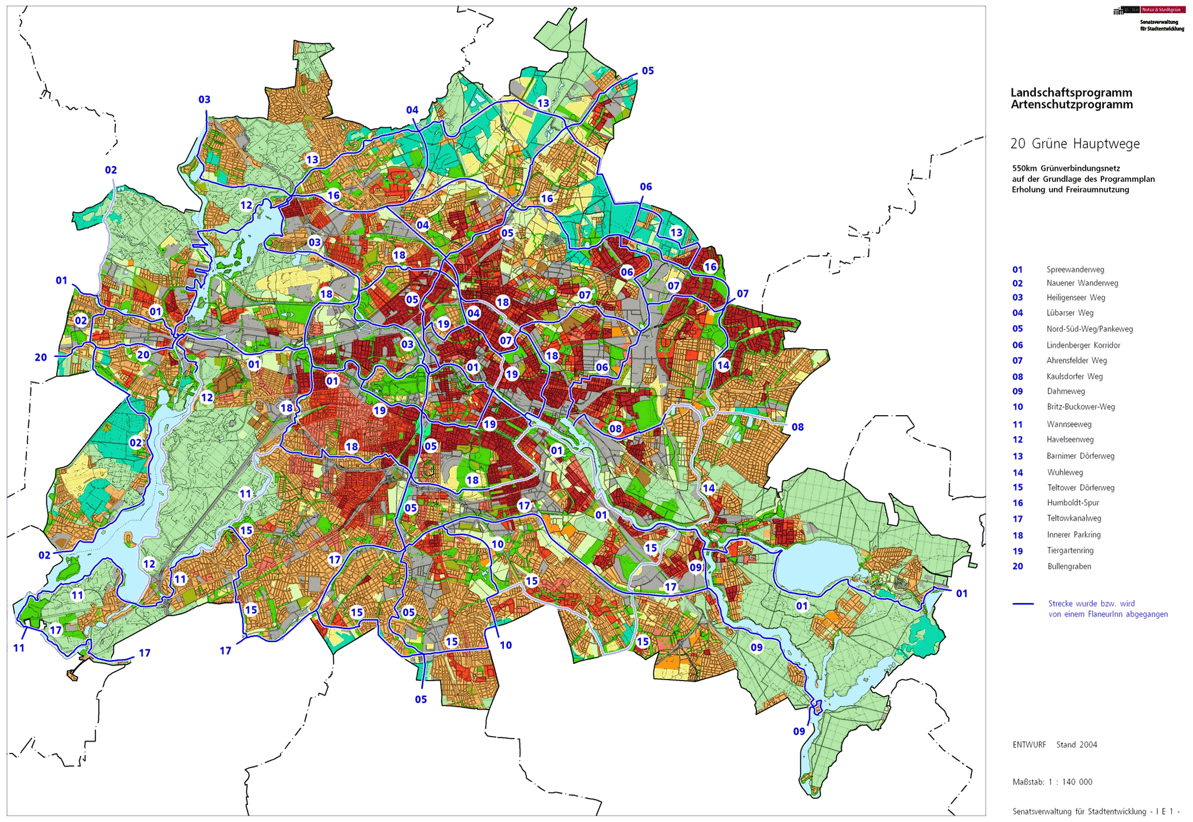
The Britz-Buckower Weg is marked with the number 10 one of the 20 green main routes . This is a compilation of 20 hiking trails through the Berlin urban area with a total length of around 550 kilometers. The aim is to link “residential areas with the diverse recreational opportunities in parks and local recreation areas in Berlin and Brandenburg ” (Senate Department for Urban Development and the Environment). The pedestrian should have the opportunity to “experience the city intensely as a combination of culture, history and ecology”.
course
The Britz-Buckower-Weg starts at the Alt-Tempelhof underground station to the Teltow Canal . It leads eleven kilometers along the industrial architecture north and south of the Teltow Canal, such as the Ullsteinhaus and the Tempelhof harbor . The course continues over huge allotment gardens: fruit trees, flower beds and vegetable beds shape the picture. On the way there is the Britzer Garten park, which is subject to entry , the route of the green main path circles the park and leads through the green settlement area of Buckow and Lichtenrade from Berlin to Großziethen .
Tempelhof


The entry point to Britz-Buckower Weg is in Tempelhof at the Alt-Tempelhof underground station with a convenient connection. From the subway exit at the corner of Tempelhofer Damm, walk away through Alt-Tempelhof to the beginning of Germaniastraße , where a path ( street 20a ) turns off to the right, past three residential buildings to Götzstraße . This tour of Hauptweg 10 is east of Tempelhofer Damm ( B 96 ) and bypasses this busy main road. Across Götzstraße between Stadtbad Tempelhof and the district central library, the path leads to a green area between the town hall and KGA 'Feldblume' to Franckepark . On its southern edge over Albrechtstrasse into Wenckebachstrasse next to the Wenckebach Clinic, whose entrance is on the round Metzplatz . At the end of the hospital grounds to the left into the Friedrich-Wilhelm-Straße it goes from the left to the Grand Master road on which the Teltowkanalweg the commercial space on the Teltow Canal bypasses. 150 meters further, Hauptweg 10 leads at the Colditzstrasse intersection to the right into this street and through the commercial and industrial zone to the Teltow Canal. The canal will later cross Volkmarstrasse on the Colditzbrücke , and there are also commercial facilities here. With the exit of Colditzstraße on Ullsteinstraße the district is left.
Mariendorf
Mariendorf is reached by entering Ullsteinstraße . The Ullsteinstraße intersection is regulated by traffic lights and has a median and opposite Colditzstraße is Britz-Buckower Weg in Friedhofsweg (entrance with barrier) at the 'Fröhliche Eintracht' colony. Before Steinhellenweg (a residential street), turn left into Lange Straße, a garden path through the KGA 'Schätzelberg' and 'Feierabend', on which you reach Rixdorfer Straße (a main street). This two-lane road with a median strip crosses into Asterweg, a garden path between Kirchhof Mariendorf III (right) and KGA 'Kleeblatt' and 'Alpental' (the garden path is called Grenzallee) and from there to the right (south) into the plum avenue KGA 'Marienglück', then at the end of the path to the left into the Kirschenallee and to the right a little way into the Birnenallee. At the exit of the garden colony, the district boundary and the KGA 'Guter Wille' is already in Britz. However, the main path bends sharply to the right into Tacitusstraße , first a green path, then the turning hammer . Further diagonally to the left into Plautiusstrasse , in the settlement area, turn left across Strasse 229 into the path on the green strip of the KGA 'Türkenpfuhl', again parallel to the Britz district boundary. At the following multi-storey residential buildings on Imbrosweg , the route crosses the diagonally intersecting district boundary to Britz, which is also the district boundary from Tempelhof-Schöneberg to Neukölln .
Britz

The Britz district is reached on a 2.5 meter wide fixed path, first behind the properties of Am Britzer Garten , then on this street to Mohriner Allee . This is moved 70 meters to the right on the western edge of Britz in the Hochkönigweg . Its western properties belong to Britz and those on the eastern side, as well as here through Hochthron- and Hochtristenweg , and Am Irissee , border on the chargeable Britzer Garten . Since a 60-wide strip of the Britzer Garden extends into the neighboring district of Mariendorf, the Wildspitzweg is used for the Britz-Buckower Weg to the right across the district border to Mariendorf. Since it is bypassed with its southwestern tip, you have to enter Mariendorf again, on the left the Britzer Garten, on the right the Dr.-Hans-Hess-Stadion, the main path leads through the green strip back to Britz. Through the Grüner Weg, a plant route of the KGA 'Friedland III', you go left through the Friedlandpromenade to Sangerhauser Weg , on the right there are parking spaces for the Britzer Garten and to the left you go to the entrance Sangerhauser Weg ( underground line U6 Alt-Mariendorf and bus 179 to the Sangerhauser Weg stop). A detour to the Britzer Garten is possible from here. However, the main path leads 100 meters to the left to Breitener Weg , a one-and-a-half-lane asphalt strip with unpaved edge strips between bush and tree zones. The Breitener Weg leads 910 meters between the Britz allotment garden colonies 'Heimaterde' (left) and 'Kurt Pöthig' (right) to the high-voltage path . Today this is a path in a 30-meter-wide green corridor on which the route of a former high-voltage line from the Leipzig area for the aluminum plant in Rummelsburg (today: Klingenberg thermal power station ) ran. The Breiter Weg is passable, the high-voltage route is separated by barriers and barriers. On the high voltage path, the Britz-Buckower Weg meets the Teltower Dörferweg (Hauptweg 15) and together both lead 140 meters to the right before leaving Britz at the southern edge of the green corridor.
Buckow

At right angles from the green strip of the high voltage path to Buckow (southwards, to the left), the path behind the residential buildings of the Bienwaldring is used. About 100 meters further, you turn into In den Garten with three-story houses on the right and a newly built row house settlement. Between the 'Marienwerder' settlement and the 'Neue Scholle' settlement ( Quarzweg , here on Glimmerweg ), a six-storey residential building on the right corner leads to Marienfelder Chaussee . This two-lane main road is crossed at a crossing together with Hauptweg 15 for 90 meters to the left towards Buckow village center. It goes into the Delmer Steig (which is initially a footpath followed by a turning area), via Salmbacher and Trimbacher Straße at the end of the road you turn right into Warmensteinacher Straße and at its right-hand property 34-42 into a remaining piece of Töpchiner Weg ( Northeast end). There follows a path through the green strip between western commercial properties on Warmensteiner Straße and residential buildings on Ernst-Arndt- and Pfarrer-Wenke-Weg (from Drusenheimer Weg ). Gerlinger Strasse is reached in a 50 meter wide green corridor. Via this street, Britz-Buckower Weg uses a park path through a green area between KGA Buckower Feldmark (right) and Landschaftspark Töpchiner Weg (left). The latter a fallow arable land with a riding and horse farm. The Teltower Dörferweg and Britz-Buckower Weg reach the city limits. On Brandenburg territory in Großziethen , the 90-meter-wide former death strip of the border installations with the Wall Trail follows the route of the Postenweg and the following farmland.
While the Teltower Dörferweg continues on the outskirts to the west (towards Lichtenrade ), the Britz-Buckower Weg ends when you reach the city and state borders.
Local transport connections
In the direction of Britz-Buckower Weg you will find the S + U-Bahnhof Tempelhof , U-Bahnhof Alt-Tempelhof and the S-Bahnhof Schichauweg with close access to the course of the green main path.
literature
- Hiking map Berlin City. Strolling - walking - hiking . 1st edition. piekart, Berlin 2012, ISBN 978-3-935863-22-3 .
Web links
- 20 Green Main Paths , website of the Berlin Senate Department for Urban Development and the Environment, accessed on January 5, 2014.
- Overview map of the 20 hiking trails , website of the Berlin Hiking Association, accessed on January 5, 2014.
Individual evidence
- ↑ a b path number: 10
- ↑ FUSS e. V.
- ↑ The BUND project "20 Green Main Paths"
- ↑ Project "20 Green Main Paths® in Berlin"
- ^ Association for hiking in the LSB Berlin
- ↑ Senate Department for Urban Development and the Environment , Unit IE Nature Conservation, Landscape Planning and Forestry
- ↑ Chronicle of the 20 green main routes on berlin.de
- ↑ 20 main green paths. In: Website of the Berlin Senate Department for Urban Development and the Environment. Retrieved January 31, 2017 .
- ↑ The BUND project “20 main green paths”. In: BUND website . Retrieved January 31, 2017 .
- ↑ FIS-Broker map display 20 green main routes - digital hiking map , since May 2014 the recommended routes have been marked in blue, plan routes that can be walked on are red and if not walkable: dashed red

01 Spreeweg | 02 Spandauer Weg | 03 Heiligenseer Weg | 04 Lübarser Weg | 05 North-South Path | 06 Lindenberg Corridor | 07 Hönower Weg | 08 Kaulsdorfer Weg | 09 Dahmeweg | 10 Britz-Buckower Weg | 11 Wannseeweg | 12 Havelseenweg | 13 Barnimer Dörferweg | 14 Wuhletal hiking trail | 15 Teltower Dörferweg | 16 Humboldt track | 17 Teltow Canal Path | 18 Inner parking ring | 19 Tiergartenring | 20 Bullengrabenweg