
Wannseeweg
| Wannseeweg | |
|---|---|
 The Berlin nature reserve "Hundekehlefenn" |
|
| Data | |
| length | 25 kilometers |
| location | Berlin (green main path) |
| Supervised by |
FOOT e. V. BUND-Berlin Citizens' Project "Network" Berliner Wanderverband Stadtentwicklung |
| Markers |
 Blue field, white "11" |
| Starting point | Park Wissmannstrasse 8 52 ° 29 ′ 23.7 ″ N , 13 ° 16 ′ 26.3 ″ E |
| Target point | Parkwegbrücke Klein-Glienicke 52 ° 24 ′ 30.9 ″ N , 13 ° 6 ′ 4 ″ E |
| Type | trail |
| Height difference | low |
| The highest point | Wissmannstrasse 8 46.1 m above sea level NN |
| Lowest point | Koblanckstrasse 31.3 m above sea level NN |
| Level of difficulty | developed way |
| season | all year round |
| particularities | The Wannseeweg connects eight lakes in the Grunewaldseenkette with the banks of the Havel and allows the transition to the Babelsberg Park . |
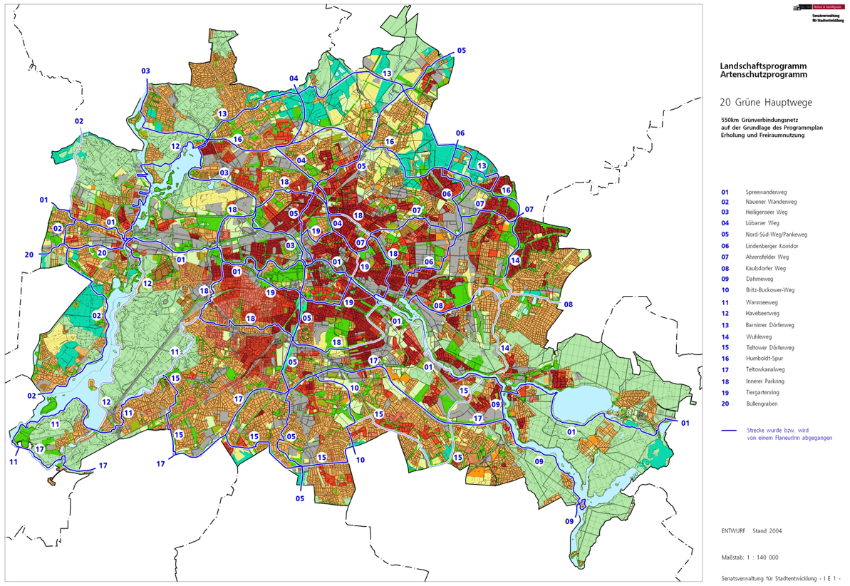
The Wannseeweg , number 11, is one of the 20 main green routes . This is a compilation of 20 hiking trails through the Berlin urban area with a total length of around 550 kilometers. The aim is to link “residential areas with the diverse recreational opportunities in parks and local recreation areas in Berlin and Brandenburg ” (Senate Department for Urban Development and the Environment). The pedestrian should have the opportunity to “experience the city intensely as a combination of culture, history and ecology”.
course

The Wannseeweg is a hiking route in the southwest of Berlin and connects eight lakes of the Grunewaldseenkette with the banks of the Havel over 25 kilometers . It leads from Koenigssee to the Berlin forest Düppel and the Potsdam park landscape almost always on wide sandy paths, past the Grunewald hunting lodge , the Pfaueninsel , Nikolskoe and the castles around the Glienicker Bridge . There are bathing spots and beer gardens along its course .
The Wannseeweg lies between inner-city green spaces in the west of Berlin on the Grunewaldseenkette and leads to the large forest areas on the Wannsee peninsula to the Havel. The description presented here is influenced by the flow directions of the adjacent rivers and is intended to form the link to the descriptions of the streets and special stations along the way.
Grunewald

The start of the Wannseeweg is in the Grunewald district on the green area of property 8 on Wissmannstraße . This is on the north bank ( maps ) of the Koenigssee between Wissmannstraße and Koenigsallee . This is also where the Inner Parkring runs along, which continues at the Hubertus and Herthasee to the Halensee . The Wannseeweg uses the Koenigsallee to the right to the Koenigsalleebrücke and leaves the street to the right at a park path (Hasensprung on the Koenigsallee 33 property) to the south bank of the Koenigssee. Straight ahead, take the Hasensprungbrücke over the connecting canal between Koenigs- and Dianasee to Winkler Straße and turn left past Bettinastraße in the arch to the square at the Grunewald station . Entry to the Wannseeweg is possible here from the Grunewald S-Bahn station . In front of the square it goes directly to the left into Auerbachstrasse, which leads along the railway facilities to the northern tip of the Grunewald landscape protection area and past the Steffi-Graf-Stadium reaches the west side of Hundekehlesee , the lake follows to the left of the path (the forest is on the right) Grunewald Forestry Office and again the Koenigsallee, on which the main path to the left is used to the Federation Reiterstaffel, in order to cross the street. Before the beginning of the development, it goes to the Hundekehlegraben in the bypass lake . It goes on the east side of the NSG Hundekehlefenn and the Grunewaldsee through the Grunewald. The bypass road is left in favor of the bank path; a path closer to the bank can also be reached via stairs. In the southern part of the Grunewaldsee in front of the Museum Jagdschloss Grunewald , the district and the district of Charlottenburg-Wilmersdorf will be left.
Dahlem

The Grunewald hunting lodge on the right of the path is in the Dahlem district ( Steglitz-Zehlendorf district ) and the Wannseeweg now changes to this district and then on the south bank the forest path is used to the right to Waldhaus Paulsborn and here the path to the left to Fenngraben, the Outflow of the Grunewaldsee. The Fenngraben lies to the right of the main path and is walked across the Hüttenweg at the border of the NSG Langes Luch near the bank of the path. In the south of the NSG on the right side of the path, the Dachsheide is crossed on the left side of the path. The Dachsheide was used for military purposes and has developed into a grassland biotope. To the east of the path, Dachsheide, on the southern edge of the Langen Luch, crosses the Fenngraben and reaches the Onkel-Tom-Straße . You leave Dahlem when you walk along the roadside.
Zehlendorf

The streets of Onkel-Tom-Straße mark the beginning of the Zehlendorf district . The Wannseeweg goes (slightly to the left) on the other side of the street ( maps ) to the northern tip of the NSG Riemeisterfenn . About 90 meters to the left the Fenngraben flows under Onkel-Tom-Straße and again reaches the main path, which it accompanies on the left. On the north side along the Riemeisterfenn, at the western end of the old waterworks, there is a change of direction to the south (turning left) across the Fenngraben. Here the Wannseeweg meets the beginning of the Teltower Dörferweg , which leads south. The Wannseeweg runs on the south bank of the Krummen Lanke , which curves to the south in the second half. The third bathing area on the Krummen Lanke ( marked as nudist ) marks the beginning of the built-up area on the Quermatensteig . The main path is close to the bank at the southern end of the Krummen Lanke and goes at right angles to the left to Fischerhüttenstraße . The outflow of the Krummen Lanke is the Wolfsschluchtkanal to the Schlachtensee . On the left side of the canal, the main path (parallel to Elvirasteig) leads to the “Old Fisherman's Hut” on the shore of the Schlachtensee. From here on, the Wannseeweg is 2.5 kilometers as a riverside path on the south bank of the Schachtensee, initially next to the properties on Terrassenstraße , around the Horn of Paul-Ernst-Park and past the S-Bahn station and a bit away from the residential buildings on Marinesteigs to the west drain of the lake, the Rehwiesengraben. At the level of the S-Bahn station, the district changed from Zehlendorf.
Nikolassee

As an extension of the Breisgauerstraße through the S-Bahn station (under the platform) to the street Am Schlachtensee , the riverside path and the main path change to the district to Nikolassee . At the lake exit, the street Am Schlachtensee is crossed at the S-Bahn underpass (railway embankment tunnel ) ( maps ) and on the other side the passage meets a forest path connection to Altvaterstraße , which leads about 50 meters to the right on the western section of Altvaterstraße between residential houses to Spanische Allee . Via this main road to the south, Gerkrathstraße leads a little higher on the east side of the LSG Rehwiese , below the Rehwiesengraben flows from the Schlachtensee. To the east of the street there are mainly villa properties, the end of Gerkrathstraße is at the turning Kirchweg , followed by a footpath from Normannenstraße , the “Rehsprung”. On Normannenstrasse, the Nikolassee S-Bahn station can be reached with the two S-Bahn lines S1 and S7. On the Normannenstrasse, the European hiking trail E11 meets the Wannseeweg and both continued to the left of the Rehwiese. It is crossed in the middle and to the left of the main path is the Nikolassee church and via the Kirchweg the Nikolassee Protestant cemetery. In the south of the Rehwiese, the Rehwiesengraben curves to the west at a distance from the Potsdamer Chaussee to the south and in particular the north-east route is at the Zehlendorf motorway junction .

A passage under the A 115 brings the Rehwiesengraben and the Wannseeweg to the other side, where the path goes south around the Nikolassee (LSG Nikolassee). Close to the north-west junction of the Zehlendorf motorway junction , a long set of stairs leads to the height of the former Berlin-Potsdamer Chaussee , which ran along the Dreilindenstraße before the motorway was built in the 1930s . The path leads through the Santa Maria School and the (Catholic) House of Saint Hedwig on the right and the AVUS branch on the left. To bypass the stairs, you can continue on the lake ( Nymphenufer ), left the Nikolassteig , then the Lohengrinstraße to the left (south) to Dreilindenstraße. The Dreilindenstraße leads the Wannseeweg to the west between the forest and the Dreilinden school on the left and villa plots on the right to the Nibelungenstraße , on the west side of which the district ends.
Wannsee

When you cross Nibelungenstraße you reach the Wannsee district , opposite Dreilindenstraße the Wannseeweg continues on a footpath through the forest on the left and the railway area on the right ( Reichsbahnstraße ), from here there is access to the Wannsee S and long-distance train station . The arched footpath to the left leads to Potsdamer Chaussee ( B 1 ) and its railway bridge. Before that, the hiking trail E11 leads over the Chaussee into the Düppel forest. The main road is called Königsstraße after the railway bridge and the Berlin Wall Trail meets the Wannseeweg at Kronprinzessinnenstraße . The Wall Trail is further (simplifying) on the byway of the main road. From Kronprinzessinnenstraße on, the Wannsee is within sight and 250 meters from the corner in front of the Wannseebrücke (drain to the Kleiner Wannsee) the Ronnebypromenade on the lakeshore leads around to the right. This is also the starting point of main path number 12 ( Havelseenweg ) to the north. Incidentally, the R1 cycle path is on the main road . After the bridge, the main path no. 11 leaves the Königstraße to the right into the street Am Großen Wannsee , in the southern part of the ring road of the "Colonie Alsen".

On the west bank of the Wannsee on the byway of the road, there are always views of the lake and especially the numerous jetties, the road is also accompanied by villa properties . The Liebermann Villa museum and the Langescheid villa are located on the branching Colomierstraße . At the Memorial House of the Wannsee Conference crossing with the street Zum Heckeshorn , the Wannseeweg goes to the right to the Wannsee bank with boat moorings, the Idstedt lion is a little offset .
From then on, to the end of the Wannseeweg, the main route always leads on the south-eastern bank of the Havel through the EU bird sanctuary of the Western Düppeler Forest . To the left on the promenade, you pass the Heckeshorn (opposite the Wannsee lido ) and continue on the path along the Großer Wannsee over the Eulenbruch to the Kleiner and Großer Tiefehorn , which protrude into the water at the northern end of the “Wannseer Peninsula” (Berlin Forest) The transition from Wannsee to the course of the Havel lies on this water surface . The path then turns to the southwest. On the opposite bank are Kälberwerder and then the Pfaueninsel . The riverside path then flows into the Pfaueninselchausee , which is reserved for bus traffic, while the Nikolskoer Weg serves as access for cars . The ferry to Pfaueninsel departs from the top ( maps ). The Wannseeweg remains (between the beer garden and the Pfaueninsel tavern, through the old stables) close to the bank, slightly higher than the water level. Together with the R1 cycle path, it is now on the banks of the Havel. At the Sacrower Kirchblick, St. Peter and Paul , Blockhaus Nikolskoe , the Appelhorn the Wannseeweg reaches the Moorlake with the historical inn there. The forest on the land side is designated as Volkspark Klein-Glienicke (Kanonenberg, Felsenteich). Around the Krughorn , the Jägerhof, the path continues to the south-southwest on the banks of the Havel and is designated as a skater route here . Shortly before the Glienicke Bridge , starting with the gardener's house, to the east on the way is the Glienicke Palace with its park. The tub sea crossing after 7.7 km along the shore, the King's Road before the B 1 to Potsdam goes. The Wannseeweg leads on the banks of the Glienicker Lake through the Jagdschlosspark and the Jagdschloss Glienicke (international meeting place). The Berlin urban area ends at the wall of the Jagdschlosspark and so Wannsee is also left.
Klein-Glienicke

When leaving the Jagdschlosspark on Möwenstrasse, the Wannseeweg enters Babelsberger Waldmüllerstrasse and meets the Wall Trail again. It continues in the Babelsberg village of Klein-Glienicke in the urban area of Potsdam (left of the Havel). The body of water on the right is the Glienicker Lake, which is the western end of the Teltow Canal and where the Teltow Canal Path (main path no. 17) ends. The Wannseeweg as main route 11 ends on Lankestrasse ( Potsdam-Babelsberg ) at the park bridge over the Teltow Canal. The long-distance hiking trail E11, which comes from the east with the Teltowkanalweg, and the Mauerweg, which come with the Wannseeweg to this northern bridge point, continue as Brandenburg hiking trails in the Babelsberg Park ( maps ).
Local transport connections
The following public transport connections are nearby:
literature
- Hiking map Berlin City. Strolling - walking - hiking . 1st edition. piekart, Berlin 2012, ISBN 978-3-935863-22-3 .
Web links
- 20 Green Main Paths , website of the Berlin Senate Department for Urban Development and the Environment, accessed on January 5, 2014.
- Overview map of the 20 hiking trails , website of the Berlin Hiking Association, accessed on January 5, 2014.
Individual evidence
- ↑ a b path number: 11
- ↑ FUSS e. V.
- ↑ The BUND project "20 Green Main Paths"
- ↑ Project "20 Green Main Paths® in Berlin"
- ^ Association for hiking in the LSB Berlin
- ↑ Senate Department for Urban Development and the Environment , Unit IE Nature Conservation, Landscape Planning and Forestry
- ↑ Chronicle of the 20 green main routes on berlin.de
- ↑ 20 main green paths. In: Website of the Berlin Senate Department for Urban Development and the Environment. Retrieved January 31, 2017 .
- ↑ The BUND project “20 main green paths”. In: BUND website . Retrieved January 31, 2017 .
- ^ Dachsheide, Berlin-Dahlem

01 Spreeweg | 02 Spandauer Weg | 03 Heiligenseer Weg | 04 Lübarser Weg | 05 North-South Path | 06 Lindenberg Corridor | 07 Hönower Weg | 08 Kaulsdorfer Weg | 09 Dahmeweg | 10 Britz-Buckower Weg | 11 Wannseeweg | 12 Havelseenweg | 13 Barnimer Dörferweg | 14 Wuhletal hiking trail | 15 Teltower Dörferweg | 16 Humboldt track | 17 Teltow Canal Path | 18 Inner parking ring | 19 Tiergartenring | 20 Bullengrabenweg