
Berlin-Nikolassee
|
Nikolassee district of Berlin |
|
|---|---|
  |
|
| Coordinates | 52 ° 26 ′ 0 ″ N , 13 ° 12 ′ 0 ″ E |
| surface | 19.61 km² |
| Residents | 16,695 (Dec. 31, 2019) |
| Population density | 851 inhabitants / km² |
| Incorporation | Oct. 1, 1920 |
| Postcodes | 14129, 14163, 14193 |
| District number | 0606 |
| Administrative district | Steglitz-Zehlendorf |
Nikolassee is a district in the Steglitz-Zehlendorf district of Berlin . In this district there is the Nikolassee , the local situation Schlachtensee and on the eastern shore of the Great Wannsee the lido Wannsee .
history

The Nikolassee villa colony was founded in 1901 and declared an independent Prussian rural community in 1910 . In 1902 the Nikolassee train station was inaugurated, which at that time was still in the open. In 1906 the complex of the later Evangelical churchyard Nikolassee was built , on which a chapel was built in 1912/1913. Opposite the cemetery, the Protestant church Nikolassee was built from 1909 and a year later the Schlachtenseer Johanneskirche was built .
The rural community Nikolassee was incorporated into Greater Berlin in 1920. In the 1930s, the Wonnegauviertel settlement was added on the eastern edge of Nikolassee .
In 1954 the Catholic Church of the Holy Twelve Apostles was built in the Schlachtenseer Wasgenstraße.
Locations and quarters

- Garden city of Düppel
- Germanic quarter
- Hubert houses: Hubert was a landowner in the 18th century. As a royal chamber councilor under Frederick II , he was commissioned in 1772 to found a colony for retired soldiers southwest of Zehlendorf. For this purpose 240 acres of poor soil had been acquired by the Zehlendorf farmers for 1000 thalers . The settlement began on the contribution-free area after 1775 and the settled and agriculturally developed area - designated as Hubert's houses - was transferred to the community by the king before 1780. This settlement was later run as the Neu-Zehlendorf colony.
- Kleistviertel
- Marine settlement
- Schlachtensee
- Wagner district, also known as the Nibelungen district
- Waldhaus district
- Wonnegauviertel
Former over-the-horizon radio relay system

Around 500 meters east of the Wannsee lido, the "Department for Post and Telecommunications of the Magistrate of Berlin " or, from January 1951, the " Senate Department for Post and Telecommunications " (SVPF, an organization Deutsche Bundespost Berlin did not exist at any time) also: Oberpostdirektion - Berlin ) for the telephone connections to West Germany via the Fernamt Berlin in Winterfeldtstrasse , the radio station Berlin 2 , which began operations in May 1951. The (weather-dependent) diffraction effect of radio waves was exploited with directional antennas and high transmission powers .
From October 20, 1952, a television connection to the Hamburg studio of the Northwest German Broadcasting Corporation (NWDR) could also be switched from there. As an antenna carrier of the OTH-radio relay system ( situation ) served three 150 meters high guyed steel lattice masts . Two of them were set up at a distance of 25 meters and formed an 'H' shape, as they were connected at a height of 120 meters via a steel truss bridge. The opposite station was the Höhbeck radio station approx. 135 kilometers away (later name: Gartow radio station ).
In the postage stamp year 1956 of the Deutsche Bundespost Berlin there was a 25 Pf special stamp ( Michel no. 157) on the occasion of the German industrial exhibition, on which the three masts of the over-the-horizon radio relay system Berlin-Nikolassee are shown.
The system, known in Berlin as “Niko” for short, lost its importance after the Schäferberg telecommunications tower was commissioned in July 1964 and the construction of the Berlin-Frohnau radio relay system began in 1970 . From 1969 to 1973 only television transmission lines ran over the "Niko" antennas. After dismantling the masts in October 1974 and dismantling the technical equipment, the site was handed over to the State Forestry Administration on May 26, 1975.
Waters in the district

- Havel and Havel lakes (on the western edge of the district from south to north)
- Islands
- Lindwerder ( location )
- Schwanenwerder ( location )
- Schlachtensee (western part) ( location )
-
Nikolassee ( location )
- Nikolasgraben ( location )
Attractions
- Architectural and natural monuments

Nikolassee S-Bahn station (built in 1901/1902 by Fritz Bräuning )

The eponymous Nikolassee
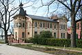
Nikolassee town hall
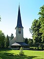
The Evangelical Church of Nikolassee , built in 1909
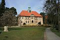
Excursion restaurant and jetty at Wannsee Castle


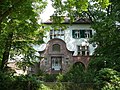
- Nikolassee villa colony

Altvaterstrasse 6, built in 1893

At Rehwiese 12, Villa Henneberg,
built in 1903
At Rehwiese 31, Landhaus Stabe,
built in 1909
Burgunder Straße 8, Blunck House,
built in 1905
Inselstraße 37, Schwanenhof,
built in 1901
Krottnaurerstraße 8, built in 1900

Libellenstrasse 7, gatehouse,
built in 1903
Libellenstrasse 17, Villa Rosenburg, built in 1902

Matterhornstrasse 67, built in 1899

Prinz-Friedrich-Leopoldstrasse 18,
built in 1903
Spanische Allee 88, built in 1916
Teutonenstrasse 24, built in 1906

Tristanstrasse 8,
built in 1906
Waldsängerpfad 3, built in 1930
.jpg)
.jpg)
.jpg)
.jpg)
.jpg)
.jpg)
.jpg)
.jpg)

.jpg)
.jpg)

.jpg)
.jpg)
See also
- List of streets and squares in Berlin-Nikolassee
- List of cultural monuments in Berlin-Nikolassee
- List of stumbling blocks in Berlin-Nikolassee
literature
- Henning Schröder, Hans H. Lembke: Nikolassee - houses and residents of the villa colony. (with the support of BVV Steglitz-Zehlendorf).
Web links
- Nikolassee - the youngest of the three HAG villa colonies in southwest Berlin ( Memento from May 9, 2017 in the Internet Archive ) on www.schroederniko.de
Individual evidence
- ↑ Overview map of Nikolassee . In: Berliner Adreßbuch , 1920, part 5, Nikolassee, p. 841.
- ↑ To the Hubertshaeusern. In: Street name lexicon of the Luisenstädtischer Bildungsverein (near Kaupert )
- ↑ Südliche Potsdamer Chaussee - Königsweg, Kleist- or Zickenviertel ( Memento from May 9, 2017 in the Internet Archive ) at www.schroederniko.de
- ^ Wannsee triangle - the Wagner quarter: Tristan and Isoldestrasse ( Memento from May 9, 2017 in the Internet Archive ) at www.schroederniko.de
- ↑ Richtfunkstelle Berlin 2 on forst-grunewald.de, accessed on July 12, 2019
- ↑ The large directional radio link from north to south on fernsehmuseum.info (Deutsches Fernsehmuseum Wiesbaden) , accessed on July 12, 2019
- ^ Günter Nitsche: The directional radio between West Berlin and West Germany - A bridge to the free world from 1948 to the fall of the Wall , August 2002. PDF; 340 kB, attachment with images , PDF; 4.9 MB, accessed July 16, 2019
