
Dahmeweg (Berlin)
| Dahmeweg | |
|---|---|
 The confluence of the Dahme and Spree rivers |
|
| Data | |
| length | 17 kilometers |
| location | Berlin (green main path) |
| Supervised by |
FOOT e. V. BUND-Berlin Citizens' Project "Network" Berliner Wanderverband Stadtentwicklung |
| Markers |
 Blue field, white "9" |
| Starting point |
Köpenick Long Bridge 52 ° 26 ′ 39.9 ″ N , 13 ° 34 ′ 10.2 ″ E |
| Target point |
Schmöckwitzwerder Wernsdorfer Strasse / L 301 52 ° 22 ′ 17.2 ″ N , 13 ° 41 ′ 44.9 ″ E |
| Type | trail |
| Height difference | none |
| The highest point | 38.7 m above sea level NN ( Grünauer Bridge ) |
| Lowest point | 34.2 m above sea level NN ( Schmöckwitz Bridge ) |
| Level of difficulty | Riverside path |
| season | all year round |
| particularities | The main path connects Köpenick with Schmöckwitz , on to the Oder-Spree Canal in Wernsdorf . |
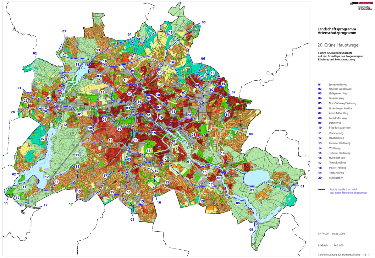
The Dahmeweg is No. 09 of the 20 main routes green . This is a compilation of 20 hiking trails through the Berlin urban area with a total length of around 550 kilometers. The aim is to link “residential areas with the diverse recreational opportunities in parks and local recreation areas in Berlin and Brandenburg ” (Senate Department for Urban Development and the Environment). The pedestrian should have the opportunity to “experience the city intensely as a combination of culture, history and ecology”.
course
The Dahmeweg opens up 17 kilometers from the banks of the Dahme to the confluence with the Spree in Köpenick . The path cannot always follow the bank, there are sometimes lake-like extensions, such as in the forest section between the Grünau lido and the Karolinenhof residential area . Apartment houses from the Wilhelminian era, villas, yachts and historic water sports club houses can be seen along the way. In the built-up area there are some cul-de-sacs to the bank, and the historic center of Schmöckwitz is touched . In the southern section, nature dominates up to the national border and beyond. The tram makes it easier to walk on the main path and becomes a river tram that travels through the forest.
Koepenick

The starting point in Köpenick is the Dahmeweg at Köllnischer Platz , at the western bridgehead of the Long Bridge , which leads over the Dahme. The Dahme needs another 350 meters to the Spree (Spreeeck), where the Spreeweg , which accompanies the course of the Spree, also leads. The Dahmeweg leads south on the lower reaches of the Grünauer Straße opposite the Köpenick Castle Island . The Dahmeufer itself is located on the property and is not directly accessible. Since most of the properties in the Köpenick locality of Köllnische Vorstadt extend to the banks of the Dahme, there is no riverside path. A view of the water is occasionally possible between the buildings, partly over fences, partly also accessible. At the Mullerecke, a headland on the Dahme and in narrow places between the road and the Dahme, such as opposite the Rohrwallinsel (Grünauer Straße 153), views and entrances are possible. Opposite the Rohrwallinsel, on the other side of the street, is the correctional facility and the KGA 'Grünauer Straße 1920'. Mostly there are old buildings on Grünauer Straße and new buildings and renovated old buildings to the south. In order to overcome the road sections of the traffic road without a view of the Dahm, it is possible to shorten these sections of the route by taking the tram to Schmöckwitz. The Köpenick part of the main path ends with Grünauer Straße on the Teltow Canal with the Grünauer Bridge .
Grünau
The district of Grünau begins on the south bank of the Teltow Canal . After the bridge into the Tauchersteig , the Teltow Canal Trail begins . At the southern bridgehead (southern bank of the Teltow Canal) the main path changes to Regattastrasse . The bank of the canal up to the Dahme is only partially accessible. Construction sites are being prepared on the fallow land (in planning: residential area 'Puerto Verde'). The Dahmeweg leads along Regattastrasse and then turns left into a branch of Regattastrasse (stop: Friedrich-Wolf-Strasse). Here the main path leads directly to the Dahmeufer for 220 meters. On the green space close to the Dahmen, pass Schlierseestraße for 310 meters along the Dahmeufer until the houses on Königsseestraße require you to turn right. At the end of the green area, the main path turns left into Dahmestrasse and at the end it turns right into Rießerseestrasse . Here it goes back to the regatta road and on this to the left. The water sports avenue runs across the green main path 09 on Regattastraße. To the left to the Dahme you will reach the ferry F12 between Grünau and Wendenschloss. The tram goes right here to the Grünau S-Bahn station . The Dahmeweg runs on Regattastraße between villas (left) and Wald (right), past Büxenstein- and Libboldallee . To the left of the street are small green spaces with benches and hedges right up to the Dahmeufer.

The regatta grandstand is 200 meters away, in front of it is the water sports museum and opposite the district forester Grünau in front of the KGA 'Grünau (Bullenwiese)'. The Schmöckwitz – Grünauer Uferbahn comes back onto Uferstraße via the Zur Uferbahn road. The path remains behind the regatta grandstand on Regattastraße and continues far from the banks of the Langen See with the Grünau regatta course. Views of the Dahme between the buildings in the bank zone are possible. The Lange See is the extension of the Dahmelauf. At the Rabindranath-Tagore-Straße the regatta street becomes a dead end and thus quieter. From Regattastraße 277 at the stop 'Regattastraße / Sportpromenade', bank access is possible again and is intended as an ideal route, but not possible on the sports promenade (as a continuation of the Regattastraße) because of the Federal Olympic Training Center for rowing and canoeing. The main path remains on the sports promenade, the forest of the NSG 'Krumme Lake' is on the right and leads past the Grünau lido. After the lido, access to the bank is reached on the bank path designated as a footpath / cycle path, vehicle traffic is prevented on the sports promenade by barriers. The route is accompanied by the tram route on the Spreeheide, which, however, shortens the headland at the Bammelecke . The shore and main path runs close to the bank around the Bammelecke, the eastern end of the Long Lake and the end of the regatta course. At the Bammelecke, the Dahme turns in the direction of flow from south-north to east-west. That is why the Dahmeweg turns - taken against the direction of flow - along the bank to the south and meets the tramway. After 730 meters from the Bammelecke and 440 meters from the tram route, you reach the Richtershorn headland with the restaurant of the same name.
Schmoeckwitz


Passing the Richtershorn peninsula, you enter the Schmöckwitz district at the level of the Großer Rohrwall island . The path for 300 meters between the forest, tram and Dahme reaches the developed area of Karolinenhof . In this villa colony there are again water properties without public bank access to the Dahme. The main path leads past the properties via Rehfeldtstrasse and Rohrwallallee . The four cross streets ( Schappachstrasse , Krugauer Steig , Lübbenauer Weg , Biebersdorfer Weg ) in the local area are spur roads to the Dahmeufer, which also allow a view of the Kleiner Rohrwall island . On the Krimnitzer Weg to the left, the compact development of Karolinenhof is abandoned, a few more pieces of land on the Dahm side with jetties block the bank. The main path leads a bit inland along a strip of forest that is 200 meters from the parallel eagle frame . After 250 meters, a green ribbon on the touring sailor Grünau 1898 breaks the property. After another 250 meters, continue on Windwallstraße with access to the (seasonal) ferry F21 to Krampenburg. On the street Zum Seeblick to the right, Adlergestell to the left, into the Imkerweg and Am Seddinsee , the Schmöckwitz (Rötschhafen) marina is bypassed. The eagle frame ends as a street at the historical center of Schmöckwitz, the tram line 68 ends in the ring road Alt-Schmöckwitz and the bus lines 168 and 733 take over further traffic. Alt-Schmöckwitz lies between the Seddinsee and the Grimnitz reservoir . The Dahme comes from the Zeuthener See through the Schmöckwitz Bridge from Brandenburg. The city boundary of Berlin to Eichwalde , south of Zeuthen, is in the direction of the source in the middle of the Dahme and its extension, the Zeuthener See. The Dahmeweg leads over the Dahmebrücke on Wernsdorfer Straße. The Seddin promenade begins on the left side of Wernsdorfer Straße on the east bank of the Dahme.
On the Oder-Spree Canal

The main path uses the Seddin promenade on the south bank of the Seddinsee . Between Seddinsee and the forest of the Schmöckwitzer Werder (with the Black Mountains) there is 1.2 kilometers on the shore to the Seddinhütte with the exit of the Oder-Spree Canal . On the south bank of this canal and on the right the forest 'Schmöckwitzer Werder' you reach the locality of Schmöckwitzwerder. At the Schmöckwitzwerder Brücke, a pedestrian bridge over the canal, take the path to the right along the 'Akademie Berlin-Schmöckwitz' and on Wernsdorfer Straße in front of the KGA 'Naturfreunde Köpenick', turn left to the city limits. The Dahmeweg ends here, and you continue over the bridge of the canal between Wernsdorfer See and Krossinsee in Brandenburg to Dorfstrasse in Wernsdorf , a district of Königs Wusterhausen .
In Brandenburg, hiking trail 3 leads south on Niederlehmer Straße to Ziegenhals and the Großer Zug , where the Dahme can be reached again in Niederlehme. To the north through Gosen ( Spreenhagen ) the bus can be used back to Berlin-Müggelheim and Köpenick.
Local transport connections
Access to the Dahmeweg is made accessible from the Spindlersfeld and Grünau S-Bahn stations and the accompanying tram line.
literature
- Hiking map Berlin City. Strolling - walking - hiking . 1st edition. piekart, Berlin 2012, ISBN 978-3-935863-22-3 .
Web links
- 20 Green Main Paths , website of the Berlin Senate Department for Urban Development and the Environment, accessed on January 5, 2014.
- Overview map of the 20 hiking trails , website of the Berlin Hiking Association, accessed on January 5, 2014.
Individual evidence
- ↑ a b path number: 9
- ↑ FUSS e. V.
- ↑ The BUND project "20 Green Main Paths"
- ↑ Project "20 Green Main Paths® in Berlin"
- ^ Association for hiking in the LSB Berlin
- ↑ Senate Department for Urban Development and the Environment , Unit IE Nature Conservation, Landscape Planning and Forestry
- ↑ Chronicle of the 20 green main routes on berlin.de
- ↑ 20 main green paths. In: Website of the Berlin Senate Department for Urban Development and the Environment. Retrieved January 31, 2017 .
- ↑ The BUND project “20 main green paths”. In: BUND website . Retrieved January 31, 2017 .

01 Spreeweg | 02 Spandauer Weg | 03 Heiligenseer Weg | 04 Lübarser Weg | 05 North-South Path | 06 Lindenberg Corridor | 07 Hönower Weg | 08 Kaulsdorfer Weg | 09 Dahmeweg | 10 Britz-Buckower Weg | 11 Wannseeweg | 12 Havelseenweg | 13 Barnimer Dörferweg | 14 Wuhletal hiking trail | 15 Teltower Dörferweg | 16 Humboldt track | 17 Teltow Canal Path | 18 Inner parking ring | 19 Tiergartenring | 20 Bullengrabenweg