
Teltow Canal Path
| Teltow Canal Path | |
|---|---|
 Teltow Canal in Lankwitz (near Leonorenstrasse) |
|
| Data | |
| length | 40 kilometers |
| location | Berlin (green main path) |
| Supervised by |
FOOT e. V. BUND-Berlin Citizens' Project "Network" Berliner Wanderverband Stadtentwicklung |
| Markers |
 Blue field, white "17" |
| Starting point |
Grünau Regatta- / Bohnsdorfer Strasse 52 ° 25 ′ 39.9 ″ N , 13 ° 34 ′ 23.1 ″ E |
| Target point |
Klein-Glienicke Waldmüller- / Lankestrasse 52 ° 24 ′ 33.4 ″ N , 13 ° 6 ′ 5.1 ″ E |
| Type | trail |
| Height difference | 6 m |
| The highest point | 38.7 m above sea level NN ( cards ) |
| Lowest point | 32.7 m above sea level NN ( cards ) |
| Level of difficulty | inner city way |
| season | all year round |
| particularities | Hauptweg 17 opens up the canal and the former wall area. |
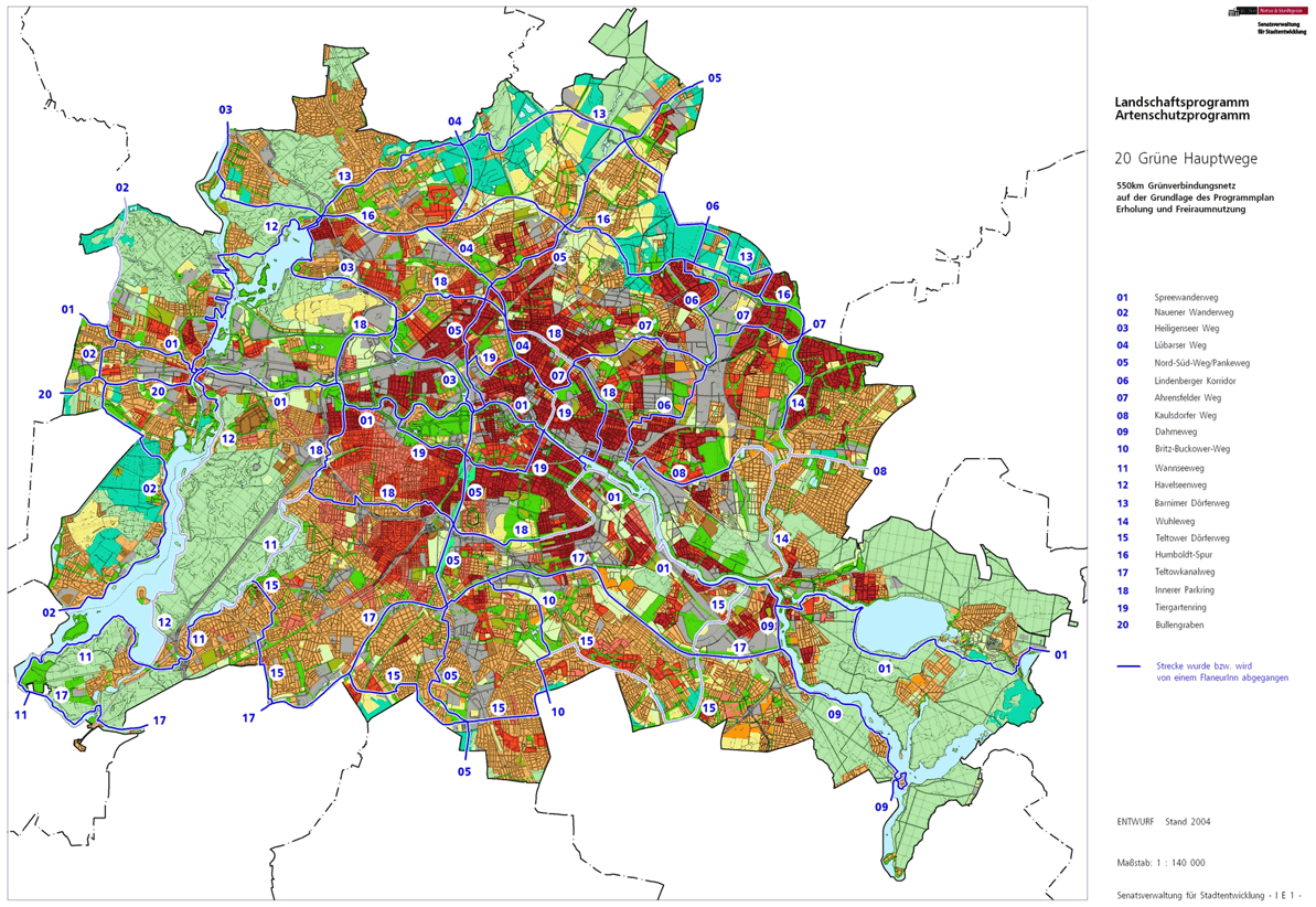
The Teltowkanalweg is with the number 17 one of the 20 main routes green . This is a compilation of 20 hiking trails through the Berlin urban area with a total length of around 550 kilometers. The aim is to link “residential areas with the diverse recreational opportunities in parks and local recreation areas in Berlin and Brandenburg ” (Senate Department for Urban Development and the Environment). The pedestrian should have the opportunity to “experience the city intensely as a combination of culture, history and ecology”.
The Teltowkanalweg follows the Teltowkanal between Dahme and Havel through the south of Berlin and the Brandenburg cities of Teltow , Kleinmachnow , Stahnsdorf and Potsdam (Babelsberg) .
course

The Teltow Canal Path is 40 kilometers for the most part on the banks of the Teltow Canal between Griebnitzsee and Dahme , only a few industrial areas in Tempelhof and a few objects on the canal have to be bypassed. The peculiarity of this green main path is on the one hand the proximity to the water, on the other hand the proximity to technological development. The navigable canal was laid through hydrologically suitable terrain between 1900 (first groundbreaking ) and 1906 (start of operation), and flowing waters such as Lanke and Bäke were included. The Teltowkanalweg uses the track bed of a towing railway , with which the barges were pulled by rope.
Grünau
The Teltow Canal Trail begins in the east at the Dahmeweg . It begins at the inflow of the canal at the Grünauer Bridge in Grünau; the path itself begins on the south bank of the canal from Regattastraße ( maps ). The canal is initially not directly accessible, and the main path leads for 330 meters on the Tauchersteig away from the bank, at the end of which to the right into the Elstersteg and at the water to the left with Am Kanal between Teltow Canal (right) and the KGA 'Grünau Krähenhorst' through. The district boundary is on the south bank of the canal; opposite is Köpenick , and Adlershof begins at the height of the Hasenlauf on the other side . The following railway bridge belongs to the Grünauer Kreuz . Under the Stelling-Janitzky bridge through which is Adlergestell crosses under. Another railway bridge follows , which leads the Görlitzer Bahn and the northwest arch of the Grünauer Kreuz (three bridge parts with a total of five tracks). The Altglienicke district is reached on the western edge of the railway bridge .
Altglienicke

In Altglienicke , the Teltowkanalweg leads into the Spreetal settlement, between the canal and allotment gardens (KGA 'Land Reform'). Something from the channel is on the corner Goldsternweg the south Altglienicker bridge the Kopenickerstrasse crossed and Teltowkanalweg on the Korkedamm initially between the KGA, Luna Park II 'and the KGA, New Garden' brought back to the channel. Opposite is the WISTA Adlershof site with the BESSY II research reactor, among other things . At the corner of Korkedamm it goes from the Idealweg to the properties Am Bruchland back to the canal bank. The Teltow Canal Bridge (also Wegedorn Bridge ) is reached on the south bank , and to the left the bridge ramp of Wegedornstraße is used to cross the canal over the bridge and leave the district.
Adlershof

There is the transition from Altglienicke, which ends on the south bank of the Teltow Canal, to Adlershof . On the north bank of the canal, the Ernst-Ruska-Ufer is used to the left, the main path uses the byway separated by a soundproof wall. The Wall Trail meets the main trail under the motorway bridge . The Teltower Dörferweg accompanies the motorway and crosses the Teltow Canal Path on a bridge to the motorway bridge over the banks of the Teltow Canal. The run through the Adlershof district ends under the motorway bridge. Since the district boundary between Rudow and Johannisthal is not directly on the north bank of the canal for about 100 meters, the main path even for this route already leads through Rudow, so the district boundary between Treptow-Köpenick and Neukölln is also located .
Johannisthal
The area north of the Teltow Canal belongs to Johannisthal, although a piece of direct bank area with the Uferweg is still Rudow, the street ( Ernst-Ruska-Ufer ) is in Johannisthal. Here, Hauptweg 17, together with the Wall Trail (formerly Postenweg), is accompanied by guard rails and fences from the street on the right and through trees and bushes from the Teltow Canal. On the opposite side of the canal is the port of Rudow Ost, followed by businesses and industrial plants. On this side, the Ernst-Ruska-Ufer leads as the Adlershof junction to the A 113, and there is a retention basin as a compensatory measure for the motorway construction. After a total of 1.6 kilometers on the riverside path, next to another retention basin, the Massante bridge is crossed and with it the Stubenrauchstrasse , which is designed here as a junction of the Hermann Gladenbeck bridge and, in turn, a short length (almost 150 meters) of the north bank Rudow. The main path is still on the asphalt strip of the riverside path next to the motorway route. Allotment gardens of Johannisthal are continuous behind the motorway, some of which were de-dedicated for the construction of the motorway. Opposite the canal in the Rudow area are the settlements on Männertreu- and Trollblumeweg . The district allocation of the Uferweg with Hauptweg 17 and Mauerweg changes (unnoticed) after 1150 meters to Baumschulenweg .
Baumschulenweg

The Teltowkanalweg in the Baumschulenweg district reaches the Ernst-Keller-Brücke over the canal after 490 meters and the Fanny-Zobel-Brücke over the motorway on which the Johannisthaler Chaussee lies between Britz and Baumschulenweg. The riverside path continues under the bridge between the banks of the Teltow Canal and the motorway. The disused Späthstrasse bridge, which no longer has a connection on the Baumschulenweg side, is located as a lattice bridge . At the new Späthstrasse bridge , which is located with the adjacent Anna-Nemitz-Brücke over the autobahn at the junction Späthstrasse, the main and wall trails separate. The Teltowkanalweg is now led on the left bypass of the Neue Späthstraße to Britz . This change of side is due to the following water systems: Britzer connecting canal, access to port Britz Ost and in particular through the arch from north-south to east-west course of the Teltow Canal.
Britz

The Britz district and the west bank of the Teltow Canal are reached at the Neue Späthstrasse Bridge. In a narrow green strip, the Uferweg, Delft Ufer , continues around allotments and school grounds to the Buschkrug Bridge . The change in direction of the Teltow Canal was due to its geological and hydrological preposition. The main path crosses the Buschkrugallee and further into the Braunschweiger Ufer , on the left here the natural monument 'Teich Britz'. Following is the Rungiusbrücke where the Rungiusstraße is crossed. The Buschkrugallee cemetery is located across the canal between the two bridges. Further on in the green belt to the Britzer Bridge , the Britzer Damm is crossed, followed by the Wilhelm Borgmann Bridge . On this 20-meter-wide bridge, the Teltow Canal Path changes its banks again, but the ideal route on the north bank of the canal through Tempelhof is not accessible because of the industrial site that follows. The course of Hauptweg 17 was laid on Tempelhofer Weg and leads around the Tempelhofer commercial and industrial areas on the Teltow Canal. The district boundary between Britz and Tempelhof is at the height of Hattenheimer Straße.
Tempelhof

The river bank in Tempelhof will be replaced by a green area above the Britz autobahn tunnel between Gottlieb-Dunkel and Teilestraße and further on the latter under the access to the Gradestraße junction and over a railway bridge on Ordensmeisterstraße to Tempelhofer Damm . In between, the green Hauptweg 10, the Britz-Buckower Weg, is crossed at the intersection of Colditz- and Ordensmeisterstraße. At Tempelhofer Damm to the left, the Teltow Canal Trail follows the north bank of the Teltow Canal again. The Wulfilaufer located here is close to the water, right on the north bank of the canal. On the other side of the canal is Mariendorf In the direction of flow of the Teltow Canal follows the Germelmann Bridge ( Alarichstraße ), the Techow Bridge ( Gersdorfstraße ) here the Wulfilaufer is left, but it continues on a green path between KGA 'Marienhöhe' and the canal bank to the Teubert Bridge , whereby the Ringstraße must be crossed. This is followed by the Teltow Canal Path along the banks of the KGA 'Erntesegen' on the west side of which the north-south path crosses, which crosses the Teltow Canal via a pedestrian bridge. The Bahnlandwirtschaft KGA 'An der Eisenbahnbrücke' is located along the Dresdener Bahn, past this and the following double-track railway bridge leads to the southern end of the village via the Tempelhof-Schöneberg district border to Steglitz-Zehlendorf .
South end / Steglitz

After the railway bridge (S-Bahn between Atillastraße and Marienfelde), the main path continues on the green strip on the canal bank parallel to the Maulbronn bank . The district boundary between Südende and Lankwitz , which also began at the railway bridge, is located on this strip of shore next to the canal bank ; the Teltow Canal Path forms this boundary. The Sieversbrücke is reached. The ideal route remains on the north bank in the south end and the green bank strip is accessible to the following railway bridge of the Anhalter suburban railway , but not the one to the west due to the proximity of the KGA 'Albrechtstraße' and 'Karl-Lange-Brücke Nord'. Thus, the Sieversbrücke with the Kaiser-Wilhelm-Straße leads to the Lankwitz area, over a staircase to the south bank to the Frankentaler Ufer , this at the corner to the left to the Gernsheimer Straße and from there to the right into the Edenkobener Weg , through the railway bridge around KGA ' Leonorenstraße / Edenkobener Weg 'and' Karl-Lange-Brücke Nord 'around. The Edenkobener Steg brings the main path back to the ideal route on the north bank and here to the left between the five-storey residential buildings on Borstellstrasse and Albrechtstrasse and the green strip on the canal further to Siemensbrücke ( Siemensstrasse ), Hannemannbrücke , Am Eichgarten shortly from the bank to the Weverpromenade. At the Prinz-Regent-Ludwig-Brücke over a zebra crossing on Birkbuschstraße and the path leading to the Paul-Schwarz-Promenade. The Bäketeich in the Bäkepark is reached to the right of the main path .
Lichterfelde


The riverside path reaches the district change from Steglitz to Lichterfelde on the western edge of the Bäkepark . Opposite on the canal bank are the Steglitz port and the Steglitz power plant in the Lankwitz district, to which a pipe bridge leads. The Teltowkanalweg as Paul-Schwarz-Promenade leads past the Charité Campus Benjamin Franklin , followed by the Schlosspark Lichterfelde, in which there is a nature reserve. At the Krahmersteg, the Krahmerstrasse is crossed on the bank (a staircase leads to Krahmerstrasse), the grounds of the Free University are on the landside . Continue along the Teltow Canal to the Bäkebrücke ( Bäkestrasse ), Emil-Schulz-Brücke ( Königsberger Strasse ), opposite the port of Lichterfelde. This is followed by a pipe bridge to the Lichterfelde thermal power station , the Eugen-Kleine-Brücke leads with the road of Wismarer Straße along the green main route 15 Teltower Dörferweg to the north bank ( Ostpreußendamm ). Both main routes lead together on the north bank to the west between the canal and KGA 'Neues Leben'. The city boundary between Berlin and Teltow lies on the Teltow Canal, 560 meters from the bridge, at the height of Aegirbad and KGA 'Am Aegirbad' , the Berlin Wall Trail is in this corner and on the south bank where the Wall stood. On the Berlin side, the industrial area of Goerzallee (industrial area Schönow on the Teltow Canal) is adjacent. The KGA 'Teltower Seeboden', which takes its name from the former Schönower See , is located in front of the industrial site . Followed by the KGA 'Am Stichkanal', the exit of the Zehlendorf branch canal is crossed by a lattice bridge for pedestrians and the riverside path from Hauptweg 15 and 17 continues to be used and leads past the sewage treatment plant for industrial wastewater.
Zehlendorf


At the Knesebeck bridge with the road link Teltower dam is (Berlin) / Zehlendorfer road (Teltow) Mauerweg from Teltower sentry on the Zehlendorfer Zollweg ( West Berlin ) across out to the north shore. These three paths on the north bank are now in Zehlendorf's location Schönow . To the north of the path are green and arable land, as well as the residential buildings of Alt-Schönow through which the Schönower Dorfgraben flows to the Teltow Canal. To the north of these areas are KGA 'Alt-Schönow' and 'Teltowblick'. The commercial area (former Teltow shipyard ) in the southeast of Zehlendorf (Berlin / Teltow / Kleinmachnow) is bypassed on the extended Sachtlebenstrasse 190 meters to the north and then 160 meters to the west to the city limits.
Kleinmachnow

The city limits of Berlin and Kleinmachnow have been reached and thus Brandenburg . The Wall Trail and main trail No. 15 leave the Teltow Canal along the city (and state) border to the north. The Teltowkanalweg leads westwards to Kleinmachnow , initially a little away from the canal on Erlenweg around a senior citizens' residential complex and an allotment garden (KGA 'Kiefernweg'), then back to the north bank of the canal. The Teltow urban area extends over the Teltow Canal, including the Rathmann Bridge, which leads the Kleinmachnower Thomas-Müntzer-Damm to Teltower Warthestrasse over the Teltow Canal. Because of the Kiebitzberge outdoor pool, the Teltowkanalweg leads on the Thomas-Müntzer-Damm to Kleinmachnow away from the canal, then at the Zehlendorfer Damm to the left towards the Friedensbrücke (bathing bridge) . Before the bridge to the right, the Teltowkanalweg continues on the north bank of the Machnower See , an extension of the canal. The road on the north shore through the seamount Park and 800 meters from the canal lock north to the site of the boatmen school at Machnower lock. The 100 meter longer path meets Stahnsdorfer Damm, which leads to the left to the lock bridge and the listed Machnower lock.
At the Schleusenbrücke, the Brandenburg Bäkewanderweg F5 leads to Berlin's green main route 17. Opposite Kleinmachnow, Stahnsdorf is now on the other bank of the canal. The Teltowkanalweg goes a little further away from the bank through south of the settlement through the adjacent forest area. The route continues under the A 115 motorway bridge near junction 5a Kleinmachnow, followed by the closed bridge in the route of the former Berlin-Stahnsdorf cemetery railway . Around a campsite, you pass the Bäkehang street on the canal bank between the camping vehicles. Finally, on the other side of the canal, there is again Berlin urban area with the local situation Albrechts Teerofen in the Wannsee district, here is the old motorway bridge of the former route of the A 115. 710 meters after the closed bridge, Berlin territory is reached again.
Wannsee

The Teltow Canal through Wannsee leads through the village of Kohlhasenbrück . The main route no. 17 crosses the disused line of the former Berlin – Potsdam trunk line, whose bridge over the canal no longer exists. On the Königsweg , the Berlin Wall Trail comes back to the Teltowkanalweg, both lead together over the Nathanbrücke to the south bank and continue on the street-wide Königsweg in the local area to the Bäkestrasse to the right. On this road, the Teltowkanalweg and the Mauerweg lead through the two Kohlhasenbrücker railway bridges of the Wannseebahn (double-track for the S-Bahn to Babelsberg and the long-distance train to Griebnitzsee ) to the Neue Kreisstraße .
Here the Wall Trail leaves the shared route and the Teltow Canal Trail over the Böckmann Bridge to the north. Further to the right along the bank, the Griebnitz Canal, which flows into the Teltow Canal, requires an arch to the north to the Hubertusbrücke and the Hubertusbaude, again to the south on the Griebnitzseepromenade you reach the Teltow Canal, which is now part of the Griebnitzsee . In addition, the Europaradweg R1 and the long-distance hiking trail E11 have reached the Teltowkanalweg at the Hubertusbrücke and they use the riverside path along the lakeshore at the Berliner Forst Düppel . On the right hand side is the LSG Tannenberge at 91 m above sea level. NN former garbage dump Wannsee , the direction of the riverside path changes at Griebnitzsee following the shore line from southwest to northeast. The Hirschberg 76 m above sea level follows on the right . NN in the nature reserve of the forest. The city boundary between Berlin-Wannsee and Potsdam-Babelsberg is in the middle of the lake.
Klein Glienicke


With the start of the developed waterfront properties on the Griebnitzsee on the left side of the path, the city limits of Berlin and Potsdam are reached. These are located on Klein Glienicker Griebnitzstraße, the city limits are on this street for 220 meters, on the other hand the Teltow Canal Path with the accompanying long-distance routes is on the city limits. The Potsdam location Klein-Glienicke is a corner of the area that extends north into the Steglitz-Zehlendorf district and had a special function at the time of the Berlin Wall . In the Potsdam area, the Griebnitzseepromenade merges into Griebnitzseestrasse and the main path is 60 meters away from the bank and leads to the left into Wannseestrasse, whose connection across the watercourse, the former Enver-Pasch Bridge, was demolished. At the Pattengraben , Waldmüllerstraße continues along Teltowkanalweg to the right. The Teltowkanalweg will be replaced by the Wannseeweg , the green Hauptweg 11 , at the level of Lankestrasse . This itself begins at the park bridge and the two long-distance routes to Brandenburg (Potsdam) continue along this route. The park bridge leads over the connection from Griebnitzsee to Glienicker Lake through which the Teltow Canal connects to the Havel. The Wannseeweg leads through the Jagdschoßpark Glienicke to Berlin and the Glienicker Bridge . From here there is a connection to the local public transport of Berlin with the bus line 316 or 250 meters over the Glienicke Bridge to the Potsdam tram with which the S-Bahn to Berlin can be reached at Potsdam Hauptbahnhof .
Local transport connections
Near terminals located at the Berlin rail network of the public transport are S + U station Hall Steglitz , Ullsteinstraße , Grenzallee and S-station Adlershof.
literature
- Hiking map Berlin City. Strolling - walking - hiking . 1st edition. piekart, Berlin 2012, ISBN 978-3-935863-22-3 .
- Peter Hahn, Jürgen Stich: Teltow Canal. Stations. Ways. Stories . (PDF) Oase Verlag, Badenweiler 2006, ISBN 3-88922-059-2 .
- Peter Hahn, Jürgen Stich: Teltow Canal. 80 stations & stories. Oase Verlag, Badenweiler 2014, ISBN 978-3-88922-101-8 .
Web links
- 20 Green Main Paths, website of the Berlin Senate Department for Urban Development and the Environment, accessed on January 5, 2014.
- Overview map of the 20 hiking trails , website of the Berlin Hiking Association, accessed on January 5, 2014.
- "100 Years of the Teltow Canal" series. In: Märkische Allgemeine Zeitung . Places along the waterway and events around the canal
- Wasser- und Schifffahrtsamt Berlin: Teltow Canal (TeK) - map, history, pictures
Individual evidence
- ↑ a b path number: 17
- ↑ FUSS e. V.
- ↑ The BUND project "20 Green Main Paths"
- ↑ Project "20 Green Main Paths® in Berlin"
- ^ Association for hiking in the LSB Berlin
- ↑ Senate Department for Urban Development and the Environment , Unit IE Nature Conservation, Landscape Planning and Forestry
- ↑ Chronicle of the 20 green main routes on berlin.de
- ↑ 20 main green paths. In: Website of the Berlin Senate Department for Urban Development and the Environment. Retrieved January 31, 2017 .
- ↑ The BUND project “20 main green paths”. In: BUND website . Retrieved January 31, 2017 .
- ↑ Berlin city map 1907

01 Spreeweg | 02 Spandauer Weg | 03 Heiligenseer Weg | 04 Lübarser Weg | 05 North-South Path | 06 Lindenberg Corridor | 07 Hönower Weg | 08 Kaulsdorfer Weg | 09 Dahmeweg | 10 Britz-Buckower Weg | 11 Wannseeweg | 12 Havelseenweg | 13 Barnimer Dörferweg | 14 Wuhletal hiking trail | 15 Teltower Dörferweg | 16 Humboldt track | 17 Teltow Canal Path | 18 Inner parking ring | 19 Tiergartenring | 20 Bullengrabenweg