
Barnimer Village Path
| Barnimer Village Path | |
|---|---|
.JPG) Barnimer Dörferweg at the bridge over the Tegeler Fließ |
|
| Data | |
| length | 31 kilometers |
| location | Berlin (green main path) |
| Supervised by |
FOOT e. V. BUND-Berlin Citizens' Project "Network" Berliner Wanderverband Stadtentwicklung |
| Markers |
 Blue field, white "13" |
| Starting point | Eichepark (Döllner Straße) 52 ° 34 ′ 15.8 ″ N , 13 ° 34 ′ 52.5 ″ E |
| Target point |
Tegeler Hafen 52 ° 35 ′ 22.3 ″ N , 13 ° 16 ′ 19.6 ″ E |
| Type | trail |
| Height difference | 0 m |
| Level of difficulty | inner city way |
| particularities | The path connects village centers in the north of Berlin. |
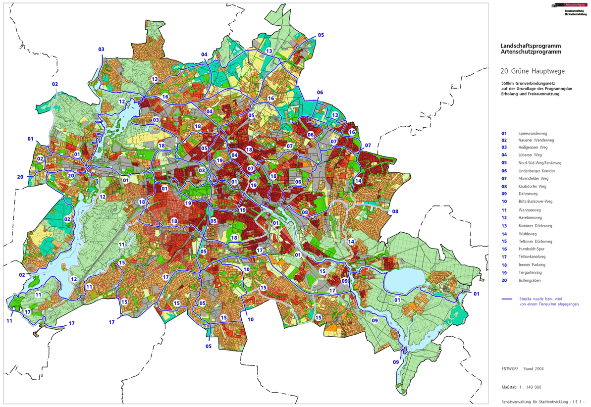
The Barnim Dörferweg connects the Tegeler See in the north-west of Berlin with the Wuhletal in the east. It is one of the city's 20 main green routes . This is a compilation of 20 hiking trails through the Berlin urban area with a total length of around 550 kilometers. The aim is to link “residential areas with the diverse recreational opportunities in parks and local recreation areas in Berlin and Brandenburg ” (Senate Department for Urban Development and the Environment). The pedestrian should have the opportunity to “experience the city intensely as a combination of culture, history and ecology”.
course
The Barnimer Dörferweg runs 31 kilometers in the north of Berlin between the historic village centers of Tegel , Hermsdorf , Lübars , Blankenfelde , Karow and Ahrensfelde along the Tegeler Fließ to the Barnimer Feldmark Regional Park
BarnimerD%C3%B6rferweg-16.jpg)
Marzahn
The eastern entry point ( location ) of the green main route 13 is at the northern entry point of the main route 14 ( Wuhletalweg ). This change is located in Marzahn at the northern end of the oak park , where the Wuhleweg continues south. The Dörferweg begins directly on the Berlin city limits to Ahrensfelde and is initially identical to Döllner Straße , which runs between a residential area in the neighboring village and the Eichepark and the Johann Julius Hecker School (named after a school reformer ). On Google Maps, Döllner Straße is incorrectly referred to as "Döliner Straße". Around the neighboring settlement along the city limits, turn right for 160 meters into Hohenwalder Strasse , which you then leave to the west at the allotment garden 'An der Wendeschleife' on Schorfheider Strasse. Since the tram turning loop (lines M8 and 16) is located here, entry into the Dörferweg on the Barnim is conceivable from here. The main path leads over the tram tracks into Eichhorster Straße between the tennis and parking lot. From Rosenbecker Straße, the green space is available next to the six-story residential block and following onto Klandorfer Straße . At the corner, go straight through the P + R places to Märkische Allee ( B 158 ), in front of the S-Bahn and regional train station to the right through the lawn to the (level) railway crossing of the Wriezener Bahn and over this on the Ahrensfelder Chaussee on the left sidewalk on the district border between Marzahn-Hellersdorf and Lichtenberg .
Falkenberg
From the Wriezener Bahn railway crossing, 170 meters on the Ahrensfelder Chaussee along the Barnimer Dörferweg across the street ( location ) to Falkenberg . The road Am Gehrensee starts as an asphalt road (next to the beginning of the industrial area) as a hiking trail with an asphalt surface further north through a green wasteland to the Gehrensee (map: settlement Am Gehrensee). However, the Barnim Dörferweg turns 80 meters before the water surface into the street Straße am Dörferweg and follows this up over the Millions Trench and here to the right into the Zehnrutenweg to the nature reserve Falkenberger Rieselfelder . In front of the former seepage basin, turn left and continue past the Heckrinderweide over Hausvater- and Steegeweg, to the south the grounds and buildings of the Berlin animal shelter . After 1140 meters, the transition to the Wartenberg district has taken place on these green spaces .
Wartenberg
After reaching the nature reserve of Wartenberg , which lies on the northern edge of the path, you continue to the area of the Berllpfuhl , where the Berllgraben begins. The village path gives way to the allotment garden complex (KGA) 'Falkenhöhe' to the south (to the left) and leads around it, where it turns right into street 3 of the Wartenberg settlement. The planned ideal tour at the KGA to the north over the Berligraben to Birkholzer Weg is marked as not (continuously) accessible. The designated Barnim Dörferweg leads at street 3 / corner street 5 to the right through the settlement over the (diagonally crossing) Birkholzer Weg to street 2 and here (300 meters before the city limits to Lindenberg / settlement 'Klarahöh') to the left between fields - and meadows to the west.
The Barnimer Dörferweg leads out of the Wartenberg settlement on road 2 to the west. 350 meters from the edge of the settlement ( location ), the transverse bush strip on Lindenberger Straße is reached, which is crossed straight ahead and past another field path after 460 meters. While the Lindenberger Corridor has the northern end point (Hauptweg 06) from the south (left), the Barnim Dörferweg goes to the right in an arched path to the northern city limits to Lindenberg in Brandenburg , which it goes along to the west. On the Lindenberger Flur there are fields, on the left on the Berlin side mainly grassland, which as the Wartenberg Landscape Park is part of the Barnim Nature Park regional park . Within sight of the Lindenberger Mühle , it goes on the city limits on a dirt road to Bundesstraße 2 , which leads north from here to the Barnim motorway triangle .
Malchow suburb
The Lichtenberg / Pankow district border is also on the east side of the B 2 and so the Barnimer Dörferweg changes across the street to the suburb of Malchow , where the main path continues on the Am Luchgraben street . The Berlin city limits are still on the right-hand side of the road and the Laake is bridged roughly in the middle . This well-developed asphalt road was laid out for the construction vehicles during the construction of the large Karow-Nord estate. The 1040 meter long cul-de-sac ends in the arch at the poplar forest, which is part of the park belt created here. These compensatory measures for the large Karow-Nord estate belong to the Barnim Nature Park , after the fall of the Wall in 1990 as the Northeast Landscape Park on the former sewage fields of the Rieselgut Blankenburg, leading to green areas in the inner city of Berlin. From the end of the street Am Luchgraben or from the parking lot opposite the Pfuhl lying on Lindenberger Flur, take the path to the left (direction southwest) 100 meters along the poplar forest, from which the cross path leading to the right bridges a ditch in the forest.
Karow
.JPG)
At the following edge of the forest the district boundary ( location ) runs to Karow , over which it goes straight through bushes at Karower drainage ditch to street 70 / corner street 64 . Barnim Dörferweg uses road 70, leaving the 'Karow settlement colony' on the left with the two to three lots of 60s streets and on the right building reservation area, consisting partly of arable land and partly of fallow land. At the end of the road, turn right into Strömannstrasse , which is on the eastern border of the village center of Karow behind the farms (now re-designated). Further 70er streets, which opened up the settlement areas in the east of Karow, will be crossed, parallel to Alt-Karow at the Spritzenhaus from 1866 the street 71 , street 72 with the cemetery Karow III, the village church and the village cemetery, street 73 , street 74 and the Siverstorpstraße partly crossing, partly branching crossed. At the end of the road, the three-storey corner buildings on Hofzeichendamm reach the outskirts of Karow (eastern part of Karow-Nord). To the left on Hofzeichenendamm, the green main path 13 leads to Alt-Karow and away from the Anger to the north as Bucher Chaussee .
Via the road leading to Buch and on to Zepernick and Bernau ( Lage ), continue straight ahead into Schönerlinder Weg . While Matestrasse leads to the right into the new development area, the Lanker Strasse following to the left marks the western edge of the village behind the former courtyards. After Busonistraße the green corridor follows the Rübländer ditch , which was renovated with the development area. Right of Eight Rutenberg , left the Wotan Street and turn right Short End Way , Röländer road provide information where the old Karower settlement area is located and indicate street names with respect to local Karow-Nord. The Barnimer Dörferweg straight ahead to the railway underpass crosses Hubertusdamm (left) and Blanchardstraße right, where the French Jean-Pierre Blanchard started his balloon ride in Karow in 1788 . Beyond the railway line, you leave the built-up Karow between allotment gardens and agricultural areas on the Schönerlinder Weg to the Panke bridge .
French Buchholz
On the east bank of the Panke , the district Karow left ( location ) and on the Schönerlinder Walk Bridge is book reached. Here on the banks of the Panke, the green main path 05 ( north-south path ) crosses , which here as the Pankewanderweg is also part of the Berlin-Usedom long-distance cycle path . The Dörferweg continues straight ahead into the NSG Karower Teiche and crosses Graben 1 Buch in its northern part , before leaving the nature reserve over the Lietzengraben to French Buchholz to the left in front of the A 10 near the Hobrechtsfelder Bridge , whose name suffix in the settlement history with Huguenots is justified. Avoiding the ideal path 180 meters to the south (left), the Bucher Straße is crossed outside the crash barriers. Opposite the main path leads into the LSG of the former Rieselfelder in decency next to the motorway; the LSG is followed by an arable area , in the south flat buildings of a pyrotechnics company. Before the 40-meter-wide strip of trees on Schönerlinder Straße ( B 109 ), turn left parallel to the Buch / French Buchholz suburbs, continue on the eastern edge of the road. This bridges the Buchholzer Graben , a trickle water collector that was installed during the construction of the Berlin outer ring ; This is followed by the exit and its bridge for the allotment gardens (Lindenhof and Birkengrund colony), then the connections to junction 2 (Schönerlinder Straße) and the A 114 (Pankower motorway feeder) itself.
Blankenfelde
Then the main road is crossed at the level of the road to Arkenberge , whereby Blankenfelde is reached. This road is marked as a skater route , officially the private road to the Arkenberge landfill . The street still forms the suburbs until the bend, to the south in the neighboring suburb the Alte Schäferei (the previous street name was Am Schafstall) and abandoned cattle stables .
At the bend in the road to Arkenberge, the main path follows the district boundary on Blankenfelder Flur to the south. ( Location ) Straight ahead is Möllersfelde (the former estate and today with a riding stables), to the right of the main path ( Schillingweg ) there is a landscape protection area with a riding stables in it, and after the Idehorstpark in front of several allotment garden colonies to the right, the path at LSG goes northwards on Idegraben (in the direction of flow) and Graben 46 Buchholz (against the direction of flow) between "Plant Idehorst" and the "NSG Idehorst", from the way east the Koppelgraben collects the two trenches. The Dörferweg leads straight through the LSG along the Grabenlauf over the Möllersfelder Weg and at the ditch bend to the left (westward) it follows it. At the Blankenfelder Graben, which is accompanied by a rider trail, the Möllersfelder Weg road is reached. On the following main road to the right opposite the abandoned stables and after 170 meters leave it again to the left and bypass the listed Blankenfeld village center on the northern edge following Graben 33 Blankenfelde . After 300 meters at the moat behind the riding arena, before the source fen, the main path leads to the right into the LSG through an open forest / bush area. The trench is reached starting from the source fen and the southwest corner of the Schwarzwassersee , from which the path to the left is taken. The accompanying flowing water is also a remnant of the Rieselfeld history of Blankenfelde.
The ditch crosses under Schildower Straße and the main path leads 175 meters to the right along the road before it crosses it to the opposite field path through the LSG around the Großer Reppfuhl. This field path leads to the Heidekrautgraben , following left to the Lübarser Bridge , where the Lübarser Weg (a street) through the Schildow-Waldeck settlement turns into Schildower Straße , a field and meadow path through the Tegeler Fliessal nature reserve, here the Köppchensee area and its wet meadows. In front of the 70 to 80 meter wide forest strip that grew on the former wall, the Lübarser Weg comes from the south together with the Berlin Wall Trail .
The Wall Trail as a developed cycle and footpath on the former border and wall strip around West Berlin , continues here on the east-side Kolonnenweg and thus crosses the Barnim Dörferweg, the Lübarser Weg continues westwards together.
Lübars
.JPG)
After the following green forest, the transition to Lübars takes place on the Pankow / Reinickendorf district border , where Berlin was once divided ( location ). The two main paths still cross the source ditch from the Osterquelle next to the path and the Küstergraben south of the Sprintwiesenteich and meet the Blankenfelder Chaussee . We continue on Alt-Lübars through the village center of the district. Here the Lübarser Weg has reached its destination and ends. At the end of the buildings on the right, the Dörferweg continues to the right into the meadow area of the LSG and on the Wördenberggraben the path that turns left and after 230 meters again to the right and straight on to the northwest to near the Tegeler Fließ, which is the city limit to Glienicke Nordbahn (State of Brandenburg ) forms. Then the settlement Kienwerder ( Am Rohrbusch ) and the KGA ' Wiesenblick ' are bypassed to the north. Following the path and next to the dog garden across the street Am Freibad , the Lübars open-air swimming pool remains on the Ziegelsee and this remains to the left of the main path. To the right of it follows the Hermsdorfer See , the shore of which is the border to the neighboring town. In the surrounding LSG, at the level of Büchenbronner Steig on the Erlenbruchgraben, is the transition to the next district, which goes back to a colony formation in Wittenau.
Waidmannslust and Hermsdorf
The Büchenbronner Steig with the eastern plots belongs to Lübars, the next district on Barnim Dörferweg is Waidmannslust where the path has changed unnoticed ( location ). It continues on the south bank of the Hermsdorfer See next to the brickwork basin (a sedimentation basin), on the northern plots of Pforzheimer Straße and Wolfacher Weg , the pipe trench in between. The bridge over the Tegeler Fließ , which is already in the neighboring district, leads to Hermsdorf , the main path continues in the LSG now on the north side of the river and thus south of the Hermsdorf town center. The bridge to the south bank on Berliner Straße ( B 96 ) is used, which leads to Waidmannslust back to Oraniendamm . After 70 meters of the main street, the riverside path leads away from the street and through the arch next to Dianastraße under the northern railway , to then switch back to the bank to Hermsdorf and at the Wickengartenteich over Brandt - / Artemisstraße , followed by Bismarcksteg. The meandering river remains to the left of the path and as the Fließalstraße provides access to ancillary properties of the Mühlenfeldstraße , on the path the Mühlenfeldteich. At the level of Jagowstraße there is a change of river bank.
Tegel
Via the Egidysteg the Tegel district becomes Marie-Schlei-Platz in the 'Freie Scholle' settlement. The green main path 13 remains in the area of the LSG on the northern edge of the settlement and has a few passages to the parallel moor path , in particular Virgilius-, Bonifazius-, Titusstraße, here the (unused) St.-Joseph-Steg. In the further on the left is the KGA 'Kirchengelände', followed by the cemetery at Fliessal. Between the cemetery and the A 111 , head south (left) to Waidmannsluster Damm . On the southern sidewalk of Waidmannsluster Damm, to the east of the approach to Hermsdorfer Damm (AS Waidmannsluster Damm / Hermsdorfer Damm), the Barnimer Dörferweg from the north and the Humboldt Lane coming from the south come together to run through both the motorway and the railway line. From Buddestraße the path is in a small green area a little off the road to the north ditch , which has a surface water treatment system here. When you reach Karolinenstraße, you need 50 meters to the right to safely cross the street at the intersection with Waidmannsluster Damm / An der Mühle .
Then it goes back to the Nordgraben and over the Karolinensteg, on over the Wilhelmsteg to the Humboldtinsel and from there on the Alexandersteg to the harbor promenade opposite the island past the Georgsteg to the former quay of the Tegeler Hafen ( International Building Exhibition 1987 ) and thus north of the Tegeler town center. At the entrance to the harbor, the Barnimer Dörferweg leaves the Humboldt-Spur by not crossing the Tegel harbor bridge , but turning left onto the Greenwich promenade. Here the Barnim Dörferweg runs for 70 meters together with the Heiligenseer Weg . The latter then arrives at Lake Tegel , while the Dörferweg ends (according to the FIS Broker illustration) before Alt-Tegel at its western entry point ( location ).
Local transport connections
Nearby public transport connections are Alt-Tegel underground station, Karow station and Ahrensfelde station.
literature
- Hiking map Berlin City. Strolling - walking - hiking . 1st edition. piekart, Berlin 2012, ISBN 978-3-935863-22-3 .
Web links
- Barnimer Dörferweg , website of the Berlin Senate Department for Urban Development and the Environment.
- Overview map of the 20 hiking trails , website of the Berlin Hiking Association, accessed on January 5, 2014.
Individual evidence
- ↑ a b path number: 13
- ↑ FUSS e. V.
- ↑ The BUND project "20 Green Main Paths"
- ↑ Project "20 Green Main Paths® in Berlin"
- ^ Association for hiking in the LSB Berlin
- ↑ Senate Department for Urban Development and the Environment , Unit IE Nature Conservation, Landscape Planning and Forestry
- ↑ Chronicle of the 20 green main routes on berlin.de
- ↑ 20 main green paths. In: Website of the Berlin Senate Department for Urban Development and the Environment. Retrieved January 31, 2017 .
- ↑ The BUND project “20 main green paths”. In: BUND website . Retrieved January 31, 2017 .
- ↑ gpx data for navigation devices
- ↑ stadtentwicklung.berlin.de: route for download (kmz and gpx)

01 Spreeweg | 02 Spandauer Weg | 03 Heiligenseer Weg | 04 Lübarser Weg | 05 North-South Path | 06 Lindenberg Corridor | 07 Hönower Weg | 08 Kaulsdorfer Weg | 09 Dahmeweg | 10 Britz-Buckower Weg | 11 Wannseeweg | 12 Havelseenweg | 13 Barnimer Dörferweg | 14 Wuhletal hiking trail | 15 Teltower Dörferweg | 16 Humboldt track | 17 Teltow Canal Path | 18 Inner parking ring | 19 Tiergartenring | 20 Bullengrabenweg