
Heiligensee way
| Heiligensee way | |
|---|---|
 Staircase at the southeast end of the Tegeler Hafenbrücke |
|
| Data | |
| length | 25 kilometers |
| location | Berlin (green main path) |
| Supervised by |
FOOT e. V. BUND-Berlin Citizens' Project "Network" Berliner Wanderverband Stadtentwicklung |
| Markers |
 Blue field, white "3" |
| Starting point | Berlin-Mitte, Elisabeth-Lüders-Steg 52 ° 31 ′ 14.2 ″ N , 13 ° 22 ′ 36.4 ″ E |
| Target point | Ruppiner Chaussee Heiligensee / Hennigsdorf 52 ° 37 ′ 30.6 ″ N , 13 ° 13 ′ 43.3 ″ E |
| Type | trail |
| Height difference | low |
| Level of difficulty | inner city way |
| season | all year round |
| particularities | 03 of the 20 hiking trails through Berlin's green urban area and parks |
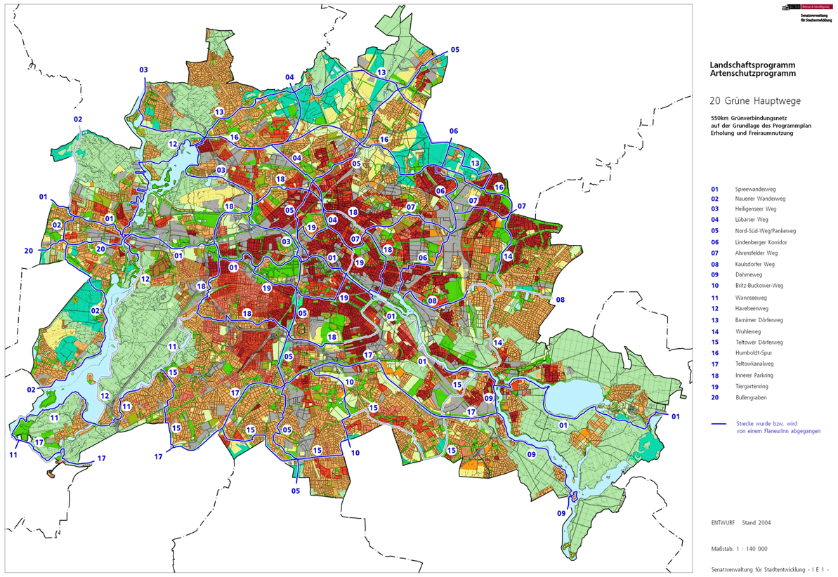
The Heiligenseer Weg , number 03, is one of the 20 main green routes . This is a compilation of 20 hiking trails through the Berlin urban area with a total length of around 550 kilometers. The aim is to link “residential areas with the diverse recreational opportunities in parks and local recreation areas in Berlin and Brandenburg ” (Senate Department for Urban Development and the Environment). The pedestrian should have the opportunity to “experience the city intensely as a combination of culture, history and ecology”.
course
The Heiligenseer Weg begins with a length of 25 kilometers on the pedestrian bridge at the Bundestag administration ( Paul-Löbe-Haus ) and leads initially along the Berlin-Spandau shipping canal and later to the northern city limits to Heiligensee . Through the natural landscape and the hustle and bustle of the city, the path accompanies the city of Berlin with its green outer areas. For example, on the only real waterfront, the Greenwichpromenade on Lake Tegel through the Tegel Forest with an old tree population. In the Berlin district of Heiligensee through single-family houses with fields in between.
center

The Heiligenseer Weg has its inner-city start in the district of Mitte on Marie-Elisabeth-Lüders-Steg , which at this point leads the Tiergartenring (green Hauptweg 19) from Otto-von-Bismarck-Allee over the Spree. This starting point can be reached from the Bundestag underground station on the U55 underground line . This starting point is right in the government district at the house of the Bundestag administration ( Paul-Löbe-Haus ). Both main routes use the (here) eastern bank of the Spree on Schiffbauerdamm , whose name changes to Kapelle-Ufer below the Kronprinzenbrücke ( Reinhardtstrasse ). Opposite the Spreebogenpark, continue along the Alexanderufer at the Futurium to the Humboldthafen . The street leads through the Stadtbahn viaduct ( S-Bahn ), the view to the main station and to the east to the Charité site. Under the Sandkrugbrücke you will go below Invalidenstrasse . The Berlin Wall Trail , which runs along the green Hauptweg 03 and the green Hauptweg 19 between the Federal Ministries and the Hamburger Bahnhof (Museum für Gegenwart) on the opposite bank of the Berlin-Spandauer Schifffahrtskanal, is a reminder of the location of the former Berlin Wall . The riverside path also leads through the Invalidenfriedhof . The parking spaces of the Bundeswehr Hospital on Scharnhorststrasse are on the right.
Wedding

The Tiergartenring turns off the bank at the Kiel Bridge . The Heiligenseer Weg continues on the bank of the shipping canal to Wedding through the Nordhafenpark- Vorfluter over the Sellerbrücke and under the Nordhafenbrücke ( Sellerstraße , B 96 ) on the north bank of the Nordhafen, further through the Fennstraße at the Fennbrücke , on the green Mettmannplatz through a high railway bridge ( flyer ), connection circle line to the main station and the ring road bridge is used the "North shore" (with car park traffic). Since the district boundary goes directly along this street, in the area of the Torfstraßensteg ( Pekinger Platz ), where the path runs directly on the canal bank, even the district Moabit is entered or the path lies directly on the district boundary. It is crossed over Föhrer Straße ( Föhrer Brücke ), followed by the buildings of the Rudolf Virchow Hospital , the Nordufer traffic road turns right into Sylter Straße. The third side of the green Eckernförde Platz is the northern Seestrasse Bridge , where the city motorway ends and here merges into Seestrasse . To the right of the riverside path is the Plötzensee (Hans-Schomburgk-Promenade) with a boat rental and an outdoor swimming pool. Opposite the canal bank, on Saatwinkler Damm, is the Plötzensee prison . The following lock Plötzensee requires the Heiligenseer Weg to avoid the northern edge of the St. Johannis- and Heilandfriedhof to the bank of the Plötzensee in the landscape protection area 'Park am Plötzensee' and further north to the LSG 'Rehberge' along the Dohnagestell. The Inner Parkring (green main path 18) connects to the wild boar enclosure in front of the Schwarzen Graben , for 500 meters along the fallow deer enclosure. The main path 18 goes straight ahead in the direction of Petersallee / Nachtigallplatz, the Heiligenseer Weg to the left (both then separates the Rehberge open-air theater) bordering the KGA 'Rehberge' and through its garden path (Kiefernweg) to the left to the Schwarzen Graben. At the end of it, you reach the Corcelle-Ring, which leads around the Julius-Leber-Kaserne . Here is the Berlin thanks France monument on Kurt-Schumacher-Damm .
Tegel
.JPG)
_Buddy_B%C3%A4r_Mieren_Maxx.jpg)
.jpg)
The change of the districts from Wedding to Tegel is on Kurt-Schumacher-Damm . This wide, busy route is now overcome into road 442 , right on road 443 to Nordlichtstraße. Via the street 462 or directly on the Kurt-Schumacher-Damm, you get to the underground station Kurt-Schumacher-Platz . The Heiligenseer Weg uses the Northern Lights Road through the 'Planetensiedlung', which got its name from the cross roads to the Meteor Road . The path still bypasses the sports fields (Uranusweg to the left) to the motorway exit ( motorway junction Reinickendorf ) of the A 111 / E 26 to Eichborndamm . The hiking trail uses the adjacent footpath, which goes through the exit of the Scharnweberstrasse underground station (here as an elevated train), on Scharnweberstrasse to the left in the direction of Tegeler Zentrum, which means that the motorway junction can also be crossed from Antonienstrasse and continue along the street the underground to Tegel and on the Seidelstraße with a view of the A 111 down it goes between Cité Guynemer (left side) and the allotment garden colony 'Gartenfreunde' (right side of the street) up to Otisstraße in Tegel. To the north of Cité Guynemer on the Schwarzen-Graben Canal and across the Seidel Canal on the north bank of the airport lake is the other main path in the ' Jungfernheide ' nature reserve .
The main path follows the north bank of the airport lake through the Jungfernheide to the southern edge of the 'Waldidyll Tegel' settlement on Sendener Weg . Along this or a bit through the forest on the Semmelweg to the corner of Sendener Weg, the hiking trail leads west over Bernauer Strasse (a main road between Tegel and Haselhorst ) south of the Tegel waterworks. This about 200 meters (to the right) to the shore of Lake Tegel , along the waterworks facilities on the lake side to Gänsewerder and at the boat stations of several fishing and boat clubs, it goes to the gasworks bridge, which leads over a canal to the former gasworks port. After another parking lot at the south end of the Borsig dam was surrounded, the riverside path is reached again, with the Borsig Dammbrücke access the Borsig port is exceeded and the other shores, the Nautical Stripes of Greenwich Promenade , along the lake used. In the lake is the Hasselwerder island , on the lake opposite the Reiherwerder peninsula between Großem Malchsee and Tegeler Forst .

The Heiligenseer Weg and the Hauptweg 16 ( Humboldt-Spur ) use the Tegeler Hafenbrücke , which is also known as the "Sechserbrücke", to cross the confluence of the Tegeler Fließ into the Tegeler See. In front of the harbor bridge, Hauptweg 13 ( Barnimer Dörferweg ) starts from Heiligenseer Weg and continues along Hauptweg 16 to Tegeler Hafen along the edge of the harbor. The Heiligenseer Weg and Hauptweg 16 (western continuation) lead past the lookout point here to the banks of the Malchsee, to the north between the children's home and jetties over the Malchseegraben and An der Malche between the Tegel leisure park and the lake. Fat Marie is in the immediate vicinity ; the oak is the oldest tree in Berlin.
The LSG 'Forst Tegel' begins on the north bank of the Großer Malchsee (for which there is a reference area). The main path 16 continues at the Waldhütte am Schwarzen Weg (an asphalt road) to the south on the lake shore, the Heiligenseer Weg to the west through the Tegel forest on the Mühlenweg towards Heiligensee. The farmers brought their grain on the Mühlenweg to the Tegeler Mühle at the harbor.
The 1.9 km long section of the Heiligenseer Weg on the Mühlenweg leads after 990 meters, i.e. about half the length, over the Konradshöher Straße . About 460 meters after the road is the " Burgsdorff-Lärche " with 42.5 meters Berlin's highest tree on the way. The main path 03 on the Mühlenweg comes to the edge of the NSG Baumberge via this alternating drawing between LSG and NSG, the path changes several times, whereby the nature reserve already belongs to Heiligensee .
Heiligensee

Into this nature reserve and thus into the destination part, a path turns right at right angles to the north. Here is a school camp (Heiligensee-Schänke) halfway to the Elchdamm . This forms the southern edge of the built-up area towards the forest. The actual green main path 03 goes to the left on the Elchdamm, past Wesselburer Weg and the garden path section of the Süderholmer Steig , to a path that extends between KGA 'Am See' and KGA 'Seebad' to the shore of the Heiligensee . However, there is currently a non-accessible (privately used) section in the LSG 'Heiligensee' on the bank. Then the main path is resumed and uses the Süderholmer Steig from the corner of Schwabstedter Weg to the green strip (corner of Heiligenseegraben) along the Heiligenseestrasse. At the intersection of Alt Heiligensee / Schulzendorfer Strasse and Heiligensee- / Hennigsdorfer Strasse , the green main path leads left to Alt-Heiligensee and between lots 4 and 8 (6 is set back) to the banks of the Nieder Neuendorfer See , which the Havel flows through. Until 1990 the Berlin Wall lay opposite on the bank . The following section of the green main path 03 along the bank is also obstructed, as the properties on Hennigsdorfer Straße (some of them are also background sections) are used up to the (Havel) bank. Access to the banks of the lake and the Havel is only possible at the level of the fishing settlement opposite the Silberhammerweg .
Due to the situation of the ownership structure on the banks of the Nieder Neuendorfer See with the state border between Berlin and Brandenburg lying in this lake, as the city border between Berlin and Hennigsdorf , a longer alternative and bypass road is recommended for this northwestern district of Berlin. After leaving the Tegel forest through the 'Baumberge' NSG, the Elchdamm is not turned, but is crossed, so that the hiking trail leads on the western edge of the Heiligenseer Südfeld and to the east in a curve around the natural monument Bumpfuhl (further northwards) and along the Wiesengraben . The Heiligenseestraße is crossed at the height of Am Dachsbau and the path on Wiesengraben continues to be used behind the property south of Heiligenseer Nordfeld. This trench joins the Rundhofer path with the Eschengraben to form the Heiligenseegraben. The green strip formed in this way on the Eschengraben (opposite to the direction of flow) to the north (along the Rundhofer path) takes up the bypass and crosses the Schulzendorfer Straße on Fürstenauer Weg. Here it goes on at the Erlengraben to the Erlengrabenteich. At the edge of the Erlengraben via Mattenbuder Path and Kurzebracker Weg , you pass the Weidengraben (outflow to the Havel). The Alder Trench itself drains from both sides. Together with the Eschengraben, these ditches (also linden, birch and hazel ditches) form the lowering of the water level for the single-family homes in this part of Heiligensee (near the Havana). The Erstzweg goes on the northern section of the Erlengraben to the Silberhammer- / corner Krantorweg , where the Lindengrabenteich is located. The hiking / cycling path, which bypasses the ideal guided tour, leads through an arched, partly paved / partly paved play road ( Silberhammerweg ) to Hennigsdorfer Straße.
suburban
The actual green main path and its Erstzweg through Heiligensee meet again at Ruppiner Straße at the level of the Anglersiedlung and Silberhammerweg. The Heiligenseer Weg leads on the road through the S-Bahn bridge to Ruppiner Chaussee . On the Ruppiner Chaussee, the main route 03 goes to the left to the state border and to Hohen Neuendorf , Stolpe-Süd . At the end of the hike, the nearby Heiligensee S-Bahn station (to the right) is also suitable.
Local transport connections
The run across the city offers several connections to local public transport in the vicinity.
- S + U-Bahnhof Hauptbahnhof ,
- Reinickendorfer Strasse underground station ,
- U + S-Bahnhof Westhafen ,
- Kurt-Schumacher-Platz underground station ,
- Scharnweberstrasse underground station ,
- Alt-Tegel underground station ,
- Heiligensee S-Bahn station .
literature
- Hiking map Berlin City. Strolling - walking - hiking . 1st edition. piekart, Berlin 2012, ISBN 978-3-935863-22-3 .
Web links
- 20 Green Main Paths , website of the Berlin Senate Department for Urban Development and the Environment, accessed on January 5, 2014.
- Overview map of the 20 hiking trails , website of the Berlin Hiking Association, accessed on January 5, 2014.
Individual evidence
- ↑ a b path number: 3
- ↑ FUSS e. V.
- ↑ The BUND project "20 Green Main Paths"
- ↑ Project "20 Green Main Paths® in Berlin"
- ^ Association for hiking in the LSB Berlin
- ↑ Senate Department for Urban Development and the Environment , Unit IE Nature Conservation, Landscape Planning and Forestry
- ↑ Chronicle of the 20 green main routes on berlin.de
- ↑ 20 main green paths. In: Website of the Berlin Senate Department for Urban Development and the Environment. Retrieved January 31, 2017 .
- ↑ The BUND project “20 main green paths”. In: BUND website . Retrieved January 31, 2017 .

01 Spreeweg | 02 Spandauer Weg | 03 Heiligenseer Weg | 04 Lübarser Weg | 05 North-South Path | 06 Lindenberg Corridor | 07 Hönower Weg | 08 Kaulsdorfer Weg | 09 Dahmeweg | 10 Britz-Buckower Weg | 11 Wannseeweg | 12 Havelseenweg | 13 Barnimer Dörferweg | 14 Wuhletal hiking trail | 15 Teltower Dörferweg | 16 Humboldt track | 17 Teltow Canal Path | 18 Inner parking ring | 19 Tiergartenring | 20 Bullengrabenweg