Nieder Neuendorfer See
| Nieder Neuendorfer See | ||
|---|---|---|

|
||
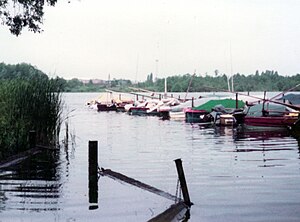
| Nieder Neuendorfer See as seen from Berlin-Heiligensee , 1982 | ||
| Geographical location | State of Brandenburg , State of Berlin ( Germany ) | |
| Tributaries | Havel | |
| Drain | Havel | |
| Places on the shore | Hennigsdorf, Berlin | |
| Data | ||
| Coordinates | 52 ° 36 '46 " N , 13 ° 12' 40" E | |
|
|
||
| surface | 9.46 hectares | |
| length | 6 km | |
| width | 0.350 km | |
| Maximum depth | 4.5 m | |
| Middle deep | 2.5 m | |
|
particularities |
River lake of the Havel |
|

|
||
The Nieder Neuendorfer See ( ), occasionally also written Niederneuendorfer See , is part of a chain of large lakes in the middle of the Havel , which extends in the course of the river to the Großer Zernsee behind Werder (Havel) .
Geography and hydrography
It is named after the Nieder Neuendorf residential area in Hennigsdorf on the west bank of the lake. The border between the federal states of Brandenburg and Berlin runs in the middle of the lake. The Berlin district of Reinickendorf (districts Heiligensee / Konradshöhe ) is located on the eastern lakeshore . In the south, the Berlin district of Spandau (district of Hakenfelde ) borders the lake. Hennigsdorf is in the north. As part of the Havel, which here belongs to the Havel-Oder waterway , it has the status of a federal waterway of waterway class IV; Responsible are the Berlin Waterways and Shipping Office (ABz 1 Spandau) and the Eberswalde Waterways and Shipping Office (ABz 1 Oranienburg). The lake is about six kilometers long from the confluence of the Teufelsseekanals to the northern end. In the area of the trade shipping fairway, an average depth of 4.50 meters is given. In contrast, the northern lake area in particular is rather flat with a tendency to silt up.
Specialty
- → Main article: Göring-Kahn
In the northern area of the water there is an artificially created pier in a north-south direction, a result of the division of Germany. In the course of securing the sector borders and the GDR national territory, a checkpoint was created in Hennigsdorf for cross-sector and cross-border inland shipping. This originated at about 10.35 km along the Oder-Havel Canal . Immediately after this artificial bottleneck, the Havel Canal, which was created in the mid-1950s bypassing West Berlin's urban area, branches off in the direction of Paretz to the west. In order to achieve a forced canalization and narrowing of the waterway, the waterways main office at that time sunk several work barges that came from the stocks of old barges in the adjacent lake area in the direction of Berlin-West in the Nieder Neuendorfer See and built them into an artificial pier using rubble and earth filling. Therefore, these ships lying there are colloquially known as pier barges.
See also
literature
- Hans-J. Uhlemann: Berlin and the Märkische waterways . transpress Verlag Berlin, various years, ISBN 3-344-00115-9
- Writings of the Association for European Inland Shipping and Waterways e. V. various years. WESKA (Western European Shipping and Harbor Calendar), Binnenschifffahrts-Verlag, Duisburg-Ruhrort. OCLC 48960431
cards
- Folke Stender: Sports boat tickets inland 1 . Nautical Publication Verlagsgesellschaft, ISBN 3-926376-10-4 .
- W. Ciesla, H. Czesienski, W. Schlomm, K. Senzel, D. Weidner: Shipping maps of the inland waterways of the German Democratic Republic 1: 10,000, Volume 4 . GDR Waterways Authority, Berlin 1988, OCLC 830889996
Web links
Individual evidence
- ↑ Directory E, serial no. 21 ( Memento of the original dated July 22, 2016 in the Internet Archive ) Info: The archive link was inserted automatically and has not yet been checked. Please check the original and archive link according to the instructions and then remove this notice. Federal Waterways and Shipping Administration
- ↑ Map of the jurisdiction of the waterways and shipping authorities
- ^ W. Ciesla, H. Czesienski, W. Schlomm, K. Senzel, D. Weidner: Shipping maps of the inland waterways of the GDR , p. 3
- ↑ Folke Stender: Sportschifffahrtskarten inland 2
