Havel Canal
| Havel Canal | |
|---|---|
|
Havel Canal |
|
| abbreviation | HvK |
| location |
|
| length | 34.18 km |
| Built | May 1951 to June 28, 1952 |
| class | IV |
| Beginning | Havel |
| The End | Havel |
| Descent structures | Schönwalde lock |
| Ports | Wustermark harbor |
| Historical precursors | Nauen-Paretz Canal |
| Used river | Joke |
| Outstanding structures | Schönwalde lock |
| Kilometrage | to the valley from the Niederneuendorfer See to the Göttinsee |
| Downhill | to the south |
| Responsible WSD | General Directorate for Waterways and Shipping - Branch Office East- |
| Brandenburg Waterways and Shipping Office | |
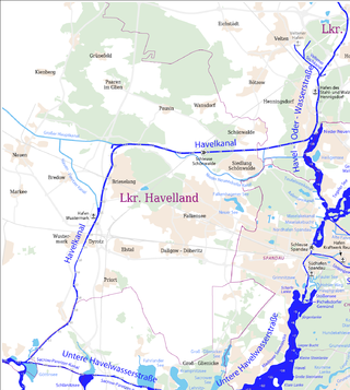
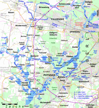
The Havel Canal , official abbreviation HvK , is a federal waterway in the state of Brandenburg and begins at km 0.41 between Nieder Neuendorf and Hennigsdorf an der Havel (km 10.30 of the Havel-Oder waterway ) and ends at km 34.59 at Paretz in near Ketzin again on the Havel (km 32.27 of the Lower Havel waterway ). It is designated as waterway class IV with restrictions; from the freight traffic center Wustermark (km 20.7) in the direction of the Untere Havel waterway, the upgrade to class Vb is underway.
It is 34.18 km long and overcomes a height difference of around two meters at the Schönwalde canal step . The water level of the Havel is on both sides of the lock .
Responsible for the administration is responsible for the initial distance to the road bridge Spandau Avenue in Hennigsdorf the fairway and Shipping Authority Berlin , then the fairway and Shipping Authority Brandenburg .
prehistory
At the beginning of the 1950s, the GDR Council of Ministers decided to expand the Brandenburg waterway network. The construction of the new canal, originally known as the Canal of Peace , was ordered by the Council of Ministers resolution of April 19, 1951. The following reasons for the construction were given at the time:
- The extensive bypassing of the Berlin urban area on the waterway between the Elbe and Oder , especially West Berlin .
- The shortening of the route between these rivers by nine kilometers.
- The creation of a connection between the aforementioned rivers that can be passed by 1000-tonne ships, bypassing the (then) too small Spandau lock .
- The improvement of the drainage of adjacent agricultural areas in the course of the collectivization of agriculture. The collectivization of agriculture was not on the plan until the 2nd party conference in July 1952.
Lines
The 34-kilometer-long canal branches off the Havel in a westerly direction at Nieder Neuendorf. After a run of 11.3 kilometers it meets the former Nieder Neuendorfer Canal , and after another 3.6 kilometers it turns south and at 16.4 kilometers it reaches the former canal bed of the Brieselang drainage canal. At 20.5 km it flows into the old Nauen-Paretz main shipping canal , the bed of which it uses for about seven kilometers. South of Buchow-Karpzow , the canal route crosses the Paarener Berg in a deep cut. This course was chosen to avoid the area of the Wublitz . In this area there are layers of bog up to 18 meters thick . To guarantee their stability, the canal dams to be built here would have required the transport of 250,000 m³ of rolling material.
The Schönwalde lock is at km 8.75 . In terms of water management, the construction of three locks was considered, but this would have been a nuisance for shipping. By building only one lock, the respective Havel water levels are effective in both the upper and the lower section. This resulted in an extensive border on both sides of the Havel Canal with flood-free canal dams. Behind the dams, new drainage and drainage ditches as well as pumping stations were built to drain the agricultural areas.
The cross section of the canal
Originally, it was planned to create the Havel Canal in two stages, of which only the first stage has been implemented to date. The first stage envisaged the two-aisle expansion for Groß-Plauer Maß ships. With a water level width of about 34.50 meters and a canal depth of 3.00 meters, the result was a cross-section of about 68 square meters. With a ship with a draft of 1.75 meters, this would result in conditions that do not correspond to a modern and contemporary waterway. In preparation for the second expansion stage, which envisaged two-aisle traffic with 1000 t ships, seven passing points including the lock outer ports were created. The alternative points are at least 500 meters long and 37 meters wide at the water level. The water depth was intended to be 3.50 meters. Since the smallest radii of curvature of the canal are 1000 meters, preparations for widening have been planned. By today's standards, the embankment fortifications are completely inadequate and do not extend to the bottom of the canal. They consist only of a nearly twenty centimeter thick rock fill with grain sizes between 150 and 250 millimeters on an approximately ten centimeter thick layer of gravel with grain sizes between 30 and 80 millimeters. The bank intended for the extension was more or less provisionally fortified with a weak layer of rubble.
lock
The Schönwalde lock at km 8.75 has a usable length of 85.00 meters and a width of 12.00 meters. The maximum drop height is 2.20 meters.
Shipping traffic at the lock
| Number of ships | ||||
|---|---|---|---|---|
| 2000 | 9406 | |||
| 2001 | 8799 | |||
| 2002 | 7719 | |||
| 2003 | 5222 | |||
| 2004 | 4583 | |||
| 2005 | 4204 | |||
| 2006 | 4166 | |||
| 2007 | 3952 | |||
| 2008 | 3826 | |||
| 2009 | 3900 | |||
| 2010 | 3695 | |||
| 2011 | 4000 | |||
| 2012 | 4026 | |||
| 2013 | 4327 | |||
| 2014 | 4212 | |||
All vehicles are considered that passed the lock. In addition to cargo ships, this also includes push boats, passenger ships, pleasure craft and other vehicles. This means a decrease in shipping traffic of 55 percent in the period mentioned.
The bridges (selection)
At least ten bridges were built over the canal when it was opened to traffic. The motorway bridge of today's BAB 10 was built in 1978. It was renewed in 2010/11, others have already been replaced by more modern bridge structures as part of various traffic projects. Only the bridges documented in the sources (literature and web links) are included. The numbering (column 1) and kilometering (column 2) are from the branch of the canal from the Havel-Oder waterway. In column 3, most of the bridges are documented in the picture. Column 4 shows the places in the vicinity of which they are located. The text column "Comments" gives the data of the bridges and, if applicable, their names and also provides information about the naming. The sixth and last column links the coordinates of the structures.
| number | km | photography | Name of the bridge / place | Remarks | Coordinates |
|---|---|---|---|---|---|
|
|
|||||
| 1 | 00.75 |
|
Road bridge Nieder Neuendorf, Nieder Neuendorf / Hennigsdorf |
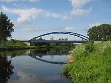
The bridge built in 1953 leads the Spandauer Allee (L 172) between Nieder Neuendorf and Hennigsdorf across the canal. It was replaced by a new building from 2017 to 2019. | cards |
| 2 | 06.49 |
|
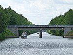
Road bridge Schönwalde, Schönwalde-Glien |
Doubtderbrücke with a central pillar, over it leads the Falkenseer Straße (L 16) between Schönwalde-Siedlung and the old town of Schönwalde north of the canal. It was built in 1952. | cards |
| 3 | 08.89 |

|
Schönwalde lock bridge, Schönwalde-Glien |
The bridge was built in 1953 and has since been partially renewed. It leads a farm path over the lower head of the lock to the Schleusenhöft. | cards |
| 4th | 09.74 |

|
Railway bridge Schönwalde, Schönwalde-Glien |
The bridge leads the Berlin outer ring over the canal. | cards |
| 5 | 14.37 |

|
Road bridge for Forsthaus Alt-Brieselang, Brieselang |
Doubt derbrücke with central pillar. The road bridge Forsthaus Alt-Brieselang was built in 1952. The Brieselanger Straße (L 201) leads over the bridge from Alt-Brieselang towards Nauen. | cards |
| 6th | 16.25 |
|
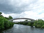
Brieselang dirt road bridge, Brieselang |
Former Doubtder Bridge with central pillar. The new bridge is a rod segment arch bridge as a bicycle and footpath bridge and connects Hafenstrasse and Karl-Marx-Strasse between an industrial complex and the town of Brieselang. | cards |
| 7th | 18.29 |

|
(Railway bridge), Brieselang |
Berlin-Hamburg train | cards |
| 8th | 18.50 |

|
Brieselang road bridge, Brieselang |
The Doubtder Bridge with a central pillar was built in 1952. It leads the Bredower Allee (Kreisstraße 6303) between Nauen and Brieselang over the Havel Canal. | cards |
| 9 | 18.80 |
|
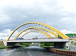
(Bridge BAB 10), Brieselang / Potsdam |
The BAB 10 motorway bridge over the Havel Canal near Brieselang is a bridge with a segment arch over the roadway with a stay cable suspension on the arch. | cards |
| 10 | 20.19 | Zeestow road bridge , Brieselang |
The Doubtder Bridge with a central pillar was built in 1952. It leads the Brieselanger Straße (L 202) over the canal. | cards | |
| X | 21.37 | ( Kuhdamm dirt road bridge ), Wustermark |
Former dirt road bridge with two pillars in the canal. The old bridge was demolished and replaced by a new one (see number 11). |
cards | |
| 11 | 21.39 |

|
Kuhdammbrücke, Wustermark |
The new bridge was completed on September 26, 2005 and handed over to the WSA Brandenburg and the municipality of Wustermark. | cards |
| 12 | 22.12 |

|
(Road bridge, Wustermark B 5 bypass), Wustermark |
cards | |
| X | 22.21 | ( Pipe bridge ), Wustermark |
At this point there was a pipe bridge that was demolished without replacement. The natural gas pipeline that crosses the canal was laid under the canal as a culvert . | cards | |
| 13 | 22.81 |

|
Railway bridge Wustermark I, Wustermark |
Berlin-Lehrter Railway | cards |
| 13a | 22.83 |

|
Railway bridge Wustermark II, Wustermark |
Berlin-Lehrter Railway | cards |
| 14th | 23.67 |
|
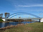
Road bridge Wustermark, Wustermark |
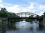
Former Zweifelder Bridge with central pillar from 1952. The bridge was replaced in 2005 by a new building. Berliner Straße / Berliner Allee leads over the tied arch bridge. | cards |
| 15th | 27.08 |

|
Buchow-Karpzow road bridge , Wustermark |
Former Zweifelder Bridge with central pillar from 1952. New bridge built in 1999, Priorter Straße (Kreisstraße 6305) leads over the bridge. | cards |
| 16 | 30.18 |

|
Road bridge Falkenrehde-Paaren, Falkenrehde / Ketzin / Havel |
In the course of the planned expansion as part of Project 17 of the German Unity Transport Project, the existing road bridge on the B 273 between Paaren and Falkenrehde over the Havel Canal from 1963 had to be completely replaced. | cards |
| 17th | 33.85 |
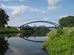
|
Road bridge Paretz, Paretz / Ketzin / Havel |
Former Zweifelder Bridge with central pillar, replaced by a tied arch bridge in 2007. Paretzer Straße crosses the bridge between the villages of Paretz and Uetz. | cards |
The construction process
Construction work on the canal began in May 1951 in two separate sections, a north and a south section. In the southern area from Paretz to Brieselang, the earthworks were almost exclusively carried out by the company using waterway management technology. Most of the work on the northern section was entrusted to state-owned companies. Her contract volume also included buildings such as the sluice maintenance farm. In the southern section, construction progress was slow in the first few months because the construction sites, the repair workshops and night lighting had to be set up. Most of the planned flushers and excavators first had to be overhauled. In addition, there was a lack of trained personnel for the large equipment. However, after overcoming the initial problems, work proceeded rapidly. The work was carried out in three lots, employing a total of 1,500 workers in a two-shift operation. At times, 16 dredgers were in use and seven flushers moved the excavated soil to the separate flushing areas. After a construction period of only 13 months, the waterway was opened to traffic on June 28, 1952. This was an exceptional achievement considering the difficult post-war conditions . The following circumstances made the construction of the canal even more difficult:
- There was no preparation time and therefore no subsoil investigation.
- The project planning was gradual , i.e. H. carried out on site.
- Only inadequate material was available in very limited quantities. This resulted in the simplest chamber wall construction of the Schönwalde lock and bridge constructions with central piers, which were a hindrance to navigation. The railway bridges were built from girder segments that could be salvaged from blown Oder bridges. At that time, these steel girders were already over fifty years old, which led to the bridges wearing out quickly.
- Only obsolete construction machines and devices that were very susceptible to repair were available. The operating staff was initially poorly trained and inexperienced.
Overall, a lock, a weir, five pumping stations, two culverts, an inlet structure, ten bridges, a lock master’s farm and an electricity master’s farm were built in the relatively short construction period. In addition, 29 kilometers of dams were raised and 60 kilometers of trenches were dug. 230,000 cubic meters of stones were used to secure the bank. Large parts of the banks were paved with rubble from Berlin. About fifty tons of explosives were used in the necessary blasting of the bog. On the canal, 40,000 trees were replanted as wind protection and around 60 hectares of flushing area were re-greened.
After 1990, a freight traffic center (GVZ) was built near Wustermark (km 21.6–22.0) and the canal was expanded from the Untere Havel waterway to the GVZ.
literature
- Gebhard Falk, Heinz-Dieter Krausch (development), Werner Schmidt (ed.): Havelland around Werder, Lehnin and Ketzin. Results of the local history inventory in the areas of Groß Kreutz, Ketzin, Lehnin and Werder (= values of the German homeland . Volume 53). 1st edition, self-published by the Institute for Regional Geography , Leipzig 1992, ISBN 3-86082-014-1 , individual representation. B 5 Havel Canal, pp. 74-75.
- Folke Stender: Sports boat tickets inland 1 . Nautical Publication Verlagsgesellschaft, ISBN 3-926376-10-4 .
- Hans-J. Uhlemann: Berlin and the Märkische waterways . transpress Verlag, Berlin, various years, ISBN 3-344-00115-9 .
- Writings of the Association for European Inland Shipping and Waterways e. V. Western European shipping and port calendar, inland shipping publishing house, Duisburg-Ruhrort various years.
- Klaus Euhausen: Nieder Neuendorf - On the history of a Brandenburg village, Hennigsdorf 2020. In it: The "Canal of Peace" with the "Bridge of German-Soviet Friendship", pp. 95–97.
Web links
Individual evidence
- ↑ Directory E, serial no. 20 der Chronik ( Memento of the original from July 22, 2016 in the Internet Archive ) Info: The archive link was inserted automatically and has not yet been checked. Please check the original and archive link according to the instructions and then remove this notice. , Federal Waterways and Shipping Administration, accessed on January 14, 2015.
- ↑ Lengths (in km) of the main shipping lanes (main routes and certain secondary routes) of the federal inland waterways ( memento of the original from January 21, 2016 in the Internet Archive ) Info: The archive link was inserted automatically and has not yet been checked. Please check the original and archive link according to the instructions and then remove this notice. , Federal Waterways and Shipping Administration, accessed on January 14, 2015.
- ↑ Hans-J. Uhlemann: Berlin and the Märkische Wasserstraßen p. 177, 1987 edition.
- ↑ Hans-J. Uhlemann: Berlin and the Märkische waterways. P. 177 ff.
- ↑ Freight traffic flows between the Elbe and Oder ( memento of the original from September 16, 2016 in the Internet Archive ) Info: The archive link was automatically inserted and not yet checked. Please check the original and archive link according to the instructions and then remove this notice. (PDF; 2 MB) as well as previous statistics ( memento of the original from September 16, 2016 in the Internet Archive ) Info: The archive link was inserted automatically and has not yet been checked. Please check the original and archive link according to the instructions and then remove this notice. of the Directorate-General for Waterways and Shipping - Branch Office East -, accessed on September 11, 2016.
- ↑ Schönwalde lock bridge WSA-Brandenburg , accessed on March 1, 2015.
- ↑ Alt-Brieselang road bridge , accessed on January 14, 2015.
- ↑ bridge at brückenweb.de; accessed on January 14, 2015.
- ↑ bridge at brueckenweb.de; accessed on January 14, 2015.
- ↑ Feldwegbrücke Kuhdamm / Wustermark , accessed on January 14, 2015.
- ↑ Documentation of the construction process , accessed on January 14, 2015.
- ↑ Writings of the Association for European Inland Shipping and Waterways e. 5th year 1995. WESKA (Western European shipping and port calendar), Binnenschifffahrts-Verlag, Duisburg-Ruhrort, page A 650
- ↑ Course of the replacement building. wsv.de; accessed on January 14, 2015.
- ^ Image of the new bridge, accessed on the roadway on January 14, 2015.
