Goddess lake
| Goddess lake | ||
|---|---|---|

|
||
| Geographical location | Potsdam-Mittelmark district | |
| Drain | to the Havel | |
| Places on the shore | goddess | |
| Data | ||
| Coordinates | 52 ° 27 '22 " N , 12 ° 53' 18" E | |
|
|
||
| Altitude above sea level | 29 m above sea level HN | |
| surface | 2.16 km² | |
| Maximum depth | 4 m | |
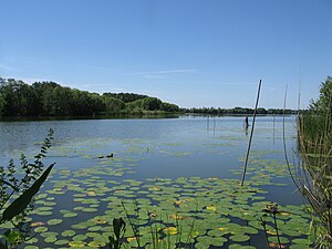
The Göttinsee (also Göttiner See ) is a lake in the Potsdam-Mittelmark district in Brandenburg .
location
The lake is located at the village of the same name, Göttin , which is on the Havel island of Töplitz . It is limited in the south by Kaltenhausen (peninsula by the Havel and See) and by the village of Göttin, in the east by meadows of the island of Töplitz, in the north by meadows of the village of Paretz and in the west by the Harnow (Havel peninsula). In addition, the Havel runs along the western border of the lake and the Sacrow-Paretz Canal runs along the northern border (with an inflow from the Havel Canal ).
Water information
The lake is approx. 1600 m long and 1000 m wide; it is about 218 hectares and up to four meters deep. Most of the lake was separated by a dam during the GDR era because it was used for fishing. On the northern course, part of the lake was cordoned off by the Sacrow-Paretzer Canal and on the western course by the Havel. In the meantime there is again a small tributary from the Havel to the Göttinsee. The water is surrounded by a belt of reeds , which occasionally opens up to small swimming and fishing spots.
See also
Web links
- Information about the lake from the Brandenburg State Environment Agency (PDF file; 244 kB)
