
Ketzin / Havel
| coat of arms | Germany map | |
|---|---|---|

|
Coordinates: 52 ° 28 ' N , 12 ° 51' E |
|
| Basic data | ||
| State : | Brandenburg | |
| County : | Havelland | |
| Height : | 32 m above sea level NHN | |
| Area : | 93.63 km 2 | |
| Residents: | 6530 (Dec. 31, 2019) | |
| Population density : | 70 inhabitants per km 2 | |
| Postal code : | 14669 | |
| Area code : | 033233 | |
| License plate : | HVL, NAU, RN | |
| Community key : | 12 0 63 148 | |
City administration address : |
Rathausstrasse 7 14669 Ketzin / Havel |
|
| Website : | ||
| Mayor : | Bernd Lück ( FDP ) | |
| Location of the city of Ketzin / Havel in the Havelland district | ||
  |
||

Ketzin / Havel is an office-free town in the Havelland between Potsdam and Brandenburg an der Havel in Havelland , Brandenburg . Until December 31, 2010 the city was called Ketzin .
geography
Ketzin is located in the south of the Havelland district between Brandenburg an der Havel (approx. 25 km) and Potsdam (approx. 22 km) on the northern bank of the Havel . In the Paretz part of the municipality, the Havel Canal and the Sacrow-Paretzer Canal branch off from the Havel. The urban area around Ketzin is a protected natural landscape with an extensive lake and quarry landscape.
Neighboring communities
The town of Ketzin / Havel borders (clockwise)
- in the north to the city of Nauen and the municipality of Wustermark in the Havelland district ,
- in the east to the independent city of Potsdam ,
- in the southeast to the city of Werder (Havel) ,
- in the south to the community of Groß Kreutz (Havel) , and
- in the west to the community of Roskow , all in the district of Potsdam-Mittelmark .
City structure
The urban area is divided into the town of Ketzin, five districts and eight residential spaces :
-
Heretic
- bridgehead
- Kliemsiedlung
- Schumacher settlement
- Voretzin
- Etzin district
- Falkenrehde district
- New falcon deer
- Paretz district
- Paretzhof
- Tremmen district
- Zachow district
- Good couples
- Fernewerder
history

Ketzin was first mentioned in a document in 1197. Ketzin and Etzin were until 1571 in the bishopric of Brandenburg , the imperial principality of the prince-bishop of the diocese of Brandenburg and were de jure not part of the Mark Brandenburg . In 1375 it was reported in the land register of Emperor Charles IV that Ketzin had ferry rights. In 1424, a market was held for the first time at the request of shoemakers and tanners . In 1738 the Ketzin fishing guild was founded.
In the middle of the 18th century, the St. Petri Church mentioned in 1197, which had been Protestant since 1541, was replaced by a new building. Only a part of the defense tower has been preserved. Of the four bells, three are more recent; one comes from Veit Dietrich (Lorraine, 1555). In 1860 the teacher Kaselitz discovered clay under the damp meadow ground with which bricks could be made. The first potters settled down in 1865, and brick factories expanded from 1870. In 1882 there were 14 large brickworks and 13 clay pits. The castle wall to the northwest (formerly 120 × 160 m) has not been preserved. It fell victim to clay mining in 1881, with Rudolf Virchow at least ensuring that the ramparts were scientifically examined beforehand, so that many finds were preserved. The sugar factory was built in 1892 (closed in 1967). On December 13, 1893, the Ketzin - Nauen railway line was opened. Since the end of passenger traffic on May 22, 1963, only goods traffic has been operated on this route. In 1900 the boatmen's and shipbuilding guild was founded, in 1911 the converted town hall was inaugurated, and the Catholic Church was built for the Catholic community founded in 1885.
In 1917 the Späth'schen nurseries, founded by Christoph Späth at Halleschen Tor in Berlin in 1720, moved to Ketzin (from Neu-Falkenrehde). The owner at the time, Hellmut Späth , was murdered on February 15, 1945 in Sachsenhausen concentration camp . On April 25, 1945 units of the Red Army closed the ring around Berlin in Ketzin and ushered in the end of the Second World War.
In 1943, the equestrian statue of the Great Elector , which until then had stood in Berlin on the central yoke of the Kurfürstenbrücke , was dismantled to protect against the effects of war and brought to Ketzin by water on a barge . It was only in January 1946 that the prahm with the equestrian statue was towed back to Berlin and moored in the Borsighafen on Lake Tegel .
In 1964, east of Ketzin in the Knoblauch community, the GDR's first underground gas storage facility was put into operation. Various gas eruptions to the surface forced the site to be abandoned in 1966/67. The residents (1964: 460) were generously compensated and settled in Ketzin, Markee and Falkenrehde. The village, including the church, was bought and demolished by the state.
Since January 1, 2011, Ketzin has been using its old town name Ketzin / Havel again.
Administrative history
Ketzin, Etzin, Falkenrehde and Paretz belonged to the Osthavelland district since 1817 , Tremmen and Zachow to the Westhavelland district in the Prussian province of Brandenburg . In 1952 the places were incorporated into the Nauen district in the GDR district of Potsdam . They have been in the Havelland district in Brandenburg since 1993.
On July 1, 1950, the place Knoblauch was incorporated. Paretz joined on January 1, 1960. Good couples had already been incorporated into Zachow on July 1, 1950.
On May 22, 1992, Ketzin merged with four municipalities to form the Ketzin Office . The seat of the official administration was the city of Ketzin. In the course of the municipal reform in Brandenburg , the Ketzin office was dissolved again on October 26, 2003. The official municipalities Etzin, Falkenrehde, Tremmen and Zachow were incorporated into the city of Ketzin at this time.
Population development

|
|
|
|
Territory of the respective year, number of inhabitants: as of December 31 (from 1991), from 2011 based on the 2011 census
politics
City Council
The city council of Ketzin consists of 18 city councilors and the full-time mayor. The local election on May 26, 2019 resulted in the following distribution of seats:
| Party / group of voters | Seats |
|---|---|
| SPD | 6th |
| CDU | 3 |
| Alliance 90 / The Greens | 2 |
| The left | 1 |
| Free voters Tremmen | 1 |
| Free voter community Falkenrehde | 1 |
| FDP | 1 |
| Free voters for Zachow 2008 | 1 |
| Individual applicant Bert Tschirner | 1 |
| Pirate Party Germany / The PARTY | 1 |
mayor
- 1998–2003: Antje Fredrich (CDU)
- since 2003: Bernd Lück (FDP)
Lück was elected in the mayoral election on September 1, 2019 with 80.1% of the valid votes for a further term of eight years.
coat of arms
The coat of arms was approved on November 5, 2004.
Blasonierung : "In blue upright next to each other and a silver Garnnadel (Knüttespun), a vise with the tip down and one with the beard outwardly introverted key."
The coat of arms was designed by the heraldist Frank Diemar .
flag
The flag is striped blue - white - blue in a ratio of 1: 3: 1 with the city arms in the middle.
Sights and culture
Attractions
See also: List of monuments in Ketzin / Havel with the monuments entered in the list of monuments of the state of Brandenburg.
Falcon deer

- Village church from 1750, structurally modified in 1910 and supplemented by the west tower
- Memorial stones from 1955 on two graves of honor for perished Soviet soldiers and prisoners of war who were interned in a barrack camp in the Neufalkenrehde district, in the cemetery behind the church in Falkenrehde
Good couples
- Medieval village church, tower probably from the 18th century, gothic renovation in 1863
- Gutshof Dorfstraße 22/23, residential building with 2 stable buildings, built around 1800 by family v. Corner crusher, listed since 2005, desolate condition
- Manor Dorfstr. 27, mainly half-timbered building from before 1700, probably modernized in the middle of the 18th century, monument protection since 2005
- Atonement Cross on Dorfstrasse
Heretic
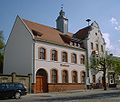
- Town hall, erected in 1887 as a farm building, until 1907 Imperial Post Office, 1911 after adding a side wing and the town hall tower
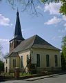
- Evangelical St. Petri Church: built 1758–1763 as a baroque hall church, the tower comes from the previous building from around 1200, inside a baroque organ front and a baroque pulpit
- Catholic Church of the Rosary Queen , built in 1910/11, a neo-Gothic brick building with a 40 meter high tower
- Ketzin station with a historic vehicle fleet, until April 2018, for example, a train of the DR class VT 18.16 (now in the DB Museum Nuremberg)
Paretz
- Paretz Castle and Gothic House
- Village church
- Post mill
Tremmen
- Evangelical St. Marien Church , single-nave, cross-shaped, arched brick building, built in the 15th century in the late Gothic style as a pilgrimage church. The two towers were raised in the baroque style in 1724 and provided with onion domes. At the west gable of the church there is an outside pulpit, from which the blessings were given to pilgrims and believers passing by.
Zachow
The origin of Zachow is in the year 1170. The village church Zachow is originally a Gothic church which was rebuilt in the 18th century in Baroque style. A gothic shuttered gable is striking. In the vicinity of Zachow is the Trebelsee , where water sports are possible.
town hall

Gothic house in Paretz

Manor house in good couples
St. Peter's Church

Ferry across the Havel in Ketzin


Regular events
In August there is an annual fisherman's festival with a large fish haul on the Havel.
Economy and Infrastructure
traffic
The state roads L 86 ( Nauen - Groß Kreutz ) and L 92 ( Roskow - Neu Fahrland ) intersect in the Ketzin district . The district of Falkenrehde cross the L 204 (formerly part of the B 273 ) and the L 862 as a connection between Ketzin and Falkenrehde. Between Ketzin and Schmergow there is a ferry over the Havel on the L 86 , which was first mentioned in 1375 as a raft.
To the east of the community runs the A 10 federal motorway (western Berlin ring road) with the Potsdam-Nord junction (approx. 8 km away).
The next train stop is Marquardt on the Jüterbog – Nauen line (part of the Berlin outer ring ), which is served by the regional train line RB 21 ( Wustermark - Potsdam Hauptbahnhof ).
The Ketzin station was the end of the Nauen – Ketzin railway line , on which passenger traffic was discontinued in 1963.
The urban area and the larger districts are served by bus lines from Potsdam and Nauen to Ketzin.
education
Personalities
sons and daughters of the town
- Carl von Schlicht (1833–1912), landscape painter, born into good couples
- Wilhelm Metzger (1848–1914), editor , politician ( SPD ), 1890–1914 member of the Reichstag
- Walter Ruppin (1885–1945), politician ( NSDAP ), born into good couples
- Joachim Illies (1925–1982), biologist and non-fiction author
- Detlef Karg (* 1945), garden historian, monument conservator and state curator
- Friedhelm Nieske (* 1954), drummer and music producer
literature
- Havelland around Werder, Lehnin and Ketzin (= values of the German homeland . Volume 53). 1st edition. Self-published by the Institute for Regional Geography, Leipzig 1992, ISBN 3-86082-014-1 .
Web links
Individual evidence
- ↑ Population in the State of Brandenburg according to municipalities, offices and municipalities not subject to official registration on December 31, 2019 (XLSX file; 223 KB) (updated official population figures) ( help on this ).
- ^ Service portal of the state administration of the state of Brandenburg - City of Ketzin / Havel
- ↑ Gustav Abb and Gottfried Wentz: The Diocese of Brandenburg . First part, In: Germania sacra , Berlin and Leipzig 1929, Walter de Gruyter, p. 68 f.
- ^ Ketzin-the Slavic castle wall
- ↑ Page no longer available , search in web archives: Märkische Allgemeine, Der Havelländer, December 30, 2010 , read on January 1, 2011
- ↑ a b c Federal Statistical Office (ed.): Municipalities 1994 and their changes since 01.01.1948 in the new federal states . Metzler-Poeschel, Stuttgart 1995, ISBN 3-8246-0321-7
- ^ Formation of the Ketzin office. Announcement by the Minister of the Interior of April 21, 1992. Official Gazette for Brandenburg - Joint Ministerial Gazette for the State of Brandenburg, Volume 3, Number 33, May 22, 1992, p. 501.
- ↑ Incorporation of the Etzin community into the city of Ketzin. Communication from the Ministry of the Interior of April 30, 2002. Official Gazette for Brandenburg Common Ministerial Gazette for the State of Brandenburg, Volume 13, 2002, Number 20, Potsdam, May 15, 2002, p. 519 PDF
- ^ Fourth law on the state-wide municipal area reform concerning the districts Havelland, Potsdam-Mittelmark, Teltow-Fläming (4th GemGebRefGBbg) of March 24, 2003, Law and Ordinance Gazette for the State of Brandenburg, I (Laws), 2003, No. 05, p 73
- ^ Historical municipality register of the state of Brandenburg 1875 to 2005. District Havelland . Pp. 14-17
- ↑ Population in the state of Brandenburg from 1991 to 2015 according to independent cities, districts and municipalities , Table 7
- ^ Office for Statistics Berlin-Brandenburg (Ed.): Statistical report AI 7, A II 3, A III 3. Population development and population status in the state of Brandenburg (respective editions of the month of December)
- ^ Result of the local election on May 26, 2019
- ↑ Results of the local elections in 1998 (mayoral elections) for the Havelland district ( Memento of the original from April 5, 2018 in the Internet Archive ) Info: The archive link was inserted automatically and has not yet been checked. Please check the original and archive link according to the instructions and then remove this notice.
- ↑ Local elections October 26, 2003. Mayoral elections , p. 25
- ↑ Brandenburg Local Election Act, Section 74
- ^ Result of the mayoral election on September 1, 2019
- ↑ Coat of arms information on the service portal of the state administration of Brandenburg
- ↑ Last "GDR ICE" on the way to the museum. Retrieved May 14, 2018 .
Brieselang | Dallgow-Döberitz | Falkensee | Friesack | Gollenberg | Big show | Havelaue | Ketzin / Havel | Kleßen-Görne | Throw up | Märkisch Luch | Milower Land | Mill mountains | Nauen | Nennhausen | Paulinenaue | Pessin | Premnitz | Rathenow | Retzow | Rhinow | Schönwalde-Glien | Lake view | Stechow-Ferchesar | Meadow meadow | Wustermark