
Nauen
| coat of arms | Germany map | |
|---|---|---|

|
Coordinates: 52 ° 36 ' N , 12 ° 53' E |
|
| Basic data | ||
| State : | Brandenburg | |
| County : | Havelland | |
| Height : | 35 m above sea level NHN | |
| Area : | 268.11 km 2 | |
| Residents: | 18,182 (Dec 31, 2019) | |
| Population density : | 68 inhabitants per km 2 | |
| Postal code : | 14641 | |
| Primaries : | 03321, 033230 (Börnicke, Tietzow), 033237 (Ribbeck), 033239 (Groß Behnitz, Schwanebeck, Wachow) | |
| License plate : | HVL, NAU, RN | |
| Community key : | 12 0 63 208 | |
| LOCODE : | DE NUQ | |
| City structure: | 14 districts | |
City administration address : |
Rathausplatz 1 14641 Nauen |
|
| Website : | ||
| Mayor : | Manuel Meger (LWN plus farmers) | |
| Location of the city of Nauen in the Havelland district | ||
  |
||

Nauen is a town in the district Havelland the country Brandenburg . In relation to its population of around 18,000, Nauen is a small town , but with a total area of over 268 km² since 2003 it has been one of the largest municipalities in Germany . In terms of infrastructure , the city functions as a middle center and is the seat of the Nauen District Court , which is the central enforcement court for the state of Brandenburg. The city is a member of the working group "Cities with historic city centers" of the state of Brandenburg. The pioneering work in radio technology carried out in the early 20th century earned it the nickname “radio city”.
geography
location
The city of Nauen forms the western part of the Osthavelland in the Havelland district . The core city of Nauen is located 27 km northwest of the state capital Potsdam and 41 km west-northwest of the center of the federal capital Berlin ; the distance to the outskirts of Berlin ( Albrechtshof train station ) is 18 km. With its total area, Nauen ranks 36th among the largest cities and municipalities in Germany, ahead of Frankfurt am Main , which is 44th . Scenically located in Nauen Havelland Luch between the expanded conservation area Nauen- Brieselang - Chandler and predominantly agricultural areas in the south and southwest.
Neighboring cities and towns
Overview:
| Paulinenaue parish in the Friesack district | Fehrbellin municipality and city Kremmen | City of Kremmen and the municipalities of Oberkrämer and Schönwalde-Glien, which are not official bodies |
| Retzow municipality in the Friesack office |
.svg)
|
Free municipality of Brieselang |
| Municipality of Märkisch Luch in the office of Nennhausen , independent city of Brandenburg an der Havel and the municipality of Päwesin in the office of Beetzsee | City of Ketzin / Havel | Free municipality of Wustermark |
geology
The landscapes of Nauen are of Ice Age origin. In geological terms, the city is located on the northern edge of the Nauener Platte , which is named after it , a ground moraine up to 15 meters thick and largely closed from the Saale Ice Age and the last Ice Age , which is partly overlaid by flat-wave terminal moraine . In the southwest of the urban area are the lakes Groß Behnitzer See , Klein Behnitzer See and Riewendsee formed in the Beetzseerinne . This glacial channel begins between the districts of Ribbeck and Berge and extends in the form of several lakes to the southeast to the city of Brandenburg an der Havel .
Environment and nature protection
- Problems
In the west-south-west of the core city of Nauen there are two lakes, which can serve as an example of a decline process due to natural and anthropogenic influences. The Groß Behnitzer See stretches along the district of Groß Behnitz, and the Klein Behnitzer See is located at the south-eastern exit of the district of Klein Behnitz . 250 years ago, in the late 18th century, it was a single, contiguous body of water. This formerly elongated Behnitzer See disintegrated into two lakes at the latest in the early 19th century due to siltation as a natural influence, whereby a siltation area formed between the newly emerging two partial lakes. A former fisherman's house, which was once on the east bank of the Behnitzer See, now stands on the silting area between the two partial lakes. In 1880, the Klein Behnitzer See, located to the south, was the larger of the two lakes. With the construction of the Klinkgraben, a drainage ditch from the Klein Behnitzer See into the Riewendsee , this was connected to the Beetzsee-Riewendsee waterway . With this anthropogenic intervention, the Klein Behnitzer See increasingly lost its volume and area . In the early 21st century, it is now the smaller of the two lakes in comparison. All of the lost water areas are covered by boggy - swampy soils and an extensive belt of reeds .
City structure


The Nauen consists of the core city Nauen and 14 are spatially located outside this core city districts , of which seven additional living spaces have. The districts belonging to the city of Nauen including their places of residence are in alphabetical order:
| Districts | associated living spaces |
|---|---|
| mountains | |
| Bergerdamm | Bergerdamm warehouse, hemp factory, Hertefeld |
| Börnicke | Ebereschenhof |
| Great Behnitz | Cross math |
| Kienberg | Teufelshof |
| Klein Behnitz | |
| Lietzow | Utershorst |
| Markee | Markau, Neugarten, Neuhof, Röthehof |
| Neukammer | |
| Ribbeck | |
| Schwanebeck | |
| Tietzow | |
| Wachow | Gohlitz , Niebede |
| Forest settlement |
history
Early history
The area around what is now the core city of Nauen has been settled since the Neolithic Age.
Middle Ages (500–1500)
One thesis regarding the naming of Nauen states that a family from Nauen am West Harz settled here and gave their new home the name of their old home . It is more likely, however, that the name comes from the Slavic word “nowo”, which means “new” or “new place”. Nauen was first mentioned in 1186 as "Nowen" in a document from Bishop Baldram of Brandenburg and not, as previously assumed, in 981. In 1292 Nauen was granted town charter , after which the citizens built the first town hall in 1302 . 1317 it was the Brandenburg Margrave Waldemar the Great , the market rights granted. Jews settled in the city as early as the Middle Ages . In 1414, a campaign of revenge by the robber baron Dietrich von Quitzow caused a great fire in the city .
Modern times (1500 to approx. 1789)
In 1631, during the Thirty Years' War , Tilly's imperial forces destroyed part of the city. During the Swedish-Brandenburg War on June 27, 1675, the " Battle of Nauen " between Swedish and Brandenburg troops took place. The billeting of the military began in 1716 . In 1732 Crown Prince Friedrich, who later became King Friedrich II of Prussia , stayed for three months as the commander of a battalion in Nauen. The construction of two barracks took place in 1767 in the area of today's district office .
Most recent (around 1790 to the 21st century)
Prussia
In 1800 the Jewish community inaugurated its synagogue at Goethestrasse 11.

German Confederation (1815–1866)
In 1816 the district of Osthavelland was established . The Jewish community was able to set up a cemetery outside the town of Am Weinberg in 1819 . Nauen became a district town in 1826 and remained so through all of the following corporate forms until the district reform in 1993. In 1846 the city was connected to the Berlin-Hamburg railway . Several major projects were carried out between 1865 and 1930, including the municipal gas works in 1865 .
North German Confederation (1867–1871)
In 1869 a higher boys' school was inaugurated .
German Empire (1871-1918)

In 1883 the volunteer fire department was founded. In 1889 the Nauen sugar factory was built . The new town hall of the city in the style of the north German brick Gothic architecture was built from 1888 to 1891. A hurricane in February 1911 caused the tower to collapse, which struck through the roof, whereupon the spire protruded into the middle of the conference room. Suburban traffic to Berlin was opened by rail in 1890 . From September 20, 1901 to April 1, 1961, Nauen was the terminus of the Rathenow-Senzke-Nauen district railway . In 1906, the radio station north of Nauen was built as a test station by Telefunken , which was expanded to become the major radio station in Nauen in 1921. This makes it the oldest still existing transmitter in the world. In 1907 a district hospital was opened, the design of which came from the Charlottenburg architects Mohr & Weidner . In 1912 the city administration had the lighting electrified. The high school in Parkstrasse was built in 1916.
Weimar Republic (1918–1933)
In 1923 the city bathing establishment opened . In 1930 the full sewerage system in the city center was completed.
Third Reich (1933–1945)
Already in the first few weeks after the NSDAP came to power, there were violent attacks on members of the labor movement ; in August 1933, for example, the workers athlete Karl Thon was kidnapped and killed by members of the Nauener SA. It was also in 1933 in a cement factory in what is now the district Börnicke by the SA 224, the -Standarte KZ Börnicke as part of the early camp Oranienburg concentration camp set up. Between 150 and 500 political prisoners - mostly communists and social democrats from the Osthavelland district - were taken into protective custody here, at least ten of whom were murdered and others died as a result of the imprisonment. After the Börnicke concentration camp was dissolved in July 1933, the camp was continued as a satellite camp of the Oranienburg concentration camp.
The Nauen synagogue was badly damaged during the November pogroms in 1938 .
At the end of the Second World War , an American air raid took place during the day on April 20, 1945 , in which 83 people died. The station and the surrounding urban areas suffered severe damage.
On April 23, 1945, under the command of Marshal Zhukov, ground troops of the 1st Belarusian Front of the Red Army , in whose ranks also troops of the 1st Polish Army fought, advanced in the course of their encirclement of the capital in preparation for the battle for Berlin against Nauen captured the city within 24 hours.
Soviet occupation zone (1945–1949)
After the end of the Second World War , Nauen belonged to the Soviet occupation zone .
German Democratic Republic (1949–1990)
Since 1952 Nauen was the district town of the Nauen district in the Potsdam district .
From October 7, 1969 to October 7, 1986, the NVA barracks of missile department 1 (abbreviation: RA-1) were located in today's Nauen district of Groß Behnitz . These barracks bore the honorary name Rudi Arndt and the cover name Ogarok (German spelling of the Russian word Огарок = "candle stub "). The rocket department 1, which had the code name Morena (German spelling of the Russian word Морена = "moraine"), was subordinate to the 1st Motorized Rifle Division (abbreviations: 1st Motorized Rifle Division or 1st MSD) in Potsdam-Eiche ,
Federal Republic of Germany (since 1990)
.jpg)
The Nauen sugar factory was closed in 1993.
Due to inflammatory letters against refugees , followed by an arson attack on the planned refugee accommodation for around 100 people on the night of August 24th to 25th, 2015, as well as the attacks on the office of the party Die Linke , Nauen was in the media in 2016 referred to as the “center of the right-wing extremist scene in Brandenburg”.
With the "Tolerance Festival Nauen", more than 30 organizations and the city administration are opposing this development. The aim is to signal in a peaceful way that a large group of people in this city are open to tolerant, democratic and solidarity-based coexistence - especially with regard to refugees, asylum seekers, older people and homosexuals. 700 participants gave an example of a colorful Nauen in 2016. They don't want the city's reputation to be ruined by the actions of a very small group of right-wing extremists.
Incorporations
For city Nauen belonged before the year 2003, the three districts Neukammer , Schwanebeck and forest settlement (Am Weinberg) . In 2003, the Brandenburg State Parliament decided on March 24th to reform the municipal area . This reform also affected the Nauen-Land office in the Havelland district , which until then had consisted of 14 communities . Of these 14 municipalities, a total of 11 municipalities became districts of the city of Nauen with effect from October 26, 2003 . These are the new districts of Berge , Bergerdamm , Börnicke , Groß Behnitz , Kienberg, Klein Behnitz, Lietzow , Markee, Ribbeck , Tietzow and Wachow .
Population development

|
|
|
|
Territory of the respective year, number of inhabitants: as of December 31 (from 1991), from 2011 based on the 2011 census .
politics

City Council
The city council of Nauen consists of 28 members and the full-time mayor with the following distribution of seats:
| Party / group of voters | Seats |
|---|---|
| Rural voter community Nauen (LWN) | 7th |
| SPD | 6th |
| CDU | 4th |
| AfD | 4th |
| The left | 2 |
| Alliance 90 / The Greens | 2 |
| Fresh wind for Nauen and districts / pirate party | 1 |
| Voting group farmers | 1 |
| FDP | 1 |
(As of: local election on May 26, 2019 )
mayor
- 2001–2017: Detlef Fleischmann ( SPD )
- since 2017: Manuel Meger (rural electoral community Nauen)
Manuel Meger was elected in the mayoral election on October 15, 2017 with 50.6% of the valid votes for a term of eight years.
badges and flags
The coat of arms was approved on January 7, 1994. Blazon : “In silver, a blue carp placed at an angle.” The colors of the flag are blue - silver (white). The cloth substrate is divided lengthways at a ratio of 1: 1. The official coat of arms can be placed in the upper half of the flag.
Town twinning
-
 Berlin-Spandau , Germany, since 1988
 -
Kreuztal , Germany, since 1991
Overview:
|
|
||
| 388 km to the city of Kreuztal in North Rhine-Westphalia | 24 km to the Spandau district of Berlin |
Sights and culture
Attractions
St. Jacobi
The Church of St. Jacobi dates back to the late Middle Ages . At the beginning of the 15th century , more precisely around 1400, the Nauener had the church built, which architecturally can be assigned to the brick Gothic. It was not until half a century later, in the second half of the 15th century, that the choir with the altar was completed. In the course of the Reformation , the church became Protestant in the 16th century . At the end of the 17th century , a fire destroyed the building, whereupon the community had the church rebuilt in 1695. Twelve years later, in 1707, the 55 m high tower with its baroque dome was placed on the original substructure. Towards the end of the 19th century , the church received an organ built in 1874 from the Heerwagen workshop .
Other churches
- The half-timbered church in Markee was built in 1697 as a replacement for the obsolete previous building. It contains pre-Reformation figures of the apostles , a picture from the Cranach School, an altar pulpit and a gallery from around 1700, as well as Art Deco paintings from the 1930s.
- From 1905 to 1906 the Catholic Church of St. Peter and Paul was built in the style of a neo-Romanesque brick basilica .
Historical old city
In the historic old town there are some buildings that were built between the 17th century and the 20th century. These include the Rathausplatz, which was completed between 1888 and 1891, with the town hall as a neo-Gothic brick building and the Sittelsche Haus. The water tower on the corner of Mauerstrasse and Goethestrasse was built in 1898 and renovated in 2006; it now includes Nauen's highest apartment. Between 1999 and 2002 we renovated in the city center, in the Art Nouveau built "Voßsche House" (Middle Road 33) and the "Barzsche house" (means 12-16) and finally the "Rumpffsche house".
Memorials
- Memorial stone for the concentration camp victims of Börnicke on the site of the former factory from 1975
- Memorial stone on the former synagogue in Goethestrasse No. 11 from 1988. In the same year, a sculpture by the artist Ingo Wellmann was installed in the Jewish cemetery in Am Weinberg in memory of the persecuted and murdered Jewish citizens.
- Soviet Cemetery of Honor: It commemorates the Soviet soldiers of the Red Army who were killed in the last days of the Second World War, as well as the slave laborers of other nations who perished in Nauen during the Second World War . The cemetery was formerly on Berliner Straße, but was moved to the municipal cemetery after reunification.
- Several stumbling blocks have been laid in the city in memory of formerly resident victims of National Socialism. → Main article: List of stumbling blocks in Nauen

Nauen water tower

Narrow half-timbered house in the old town of Nauen (Goethestrasse)

Evangelical Church of St. Jacobi
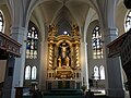
High altar of St. Jacobi

Catholic Church of St. Peter and Paul
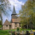
Christ Church in Markee


Film productions
Nauen served as the backdrop for the production of 16 films. So parts of the DEFA - feature film " Solo Sunny ", which appeared in 1980, shot in the market street in Nauen.
Economy and Infrastructure
With regard to its infrastructural and economic geographic importance, Nauen is one of three medium-sized centers in the Havelland district, alongside Falkensee and Rathenow .
economy
Radio transmission systems

_bei_Gro%C3%9F_Behnitz.JPG)
In the first quarter of the 20th century, important pioneering work in radio technology was carried out at the Nauen radio station . These achievements earned the city the nickname "Funkstadt".
Since August 19, 1906, when the large radio station for wireless telegraphy was put into operation, Nauen has been the location of important transmitters ( 52 ° 8 ′ 51 ″ N , 12 ° 54 ′ 31 ″ E ). Initially, the system was used to transmit telegrams over long distances without cables, with the long-term goal of radio contact to the German colonies in Africa and Asia. Until 1945 there was a large broadcasting center for long and short wave in Nauen with a wire antenna that spanned an area larger than the Principality of Monaco . The masts, which were up to 260 meters high, were among the tallest structures in Europe. In 1913, ranges of up to 6,400 kilometers were achieved. The phone calls from here to Vienna were clearly understandable. With the beginning of the First World War , the radio station was also of military importance. Because the Entente cut the German overseas cable, the system now became the gateway to the world. It was from here that the Reich directed its submarine fleet and it was here that it maintained contact with the colonies. In 1918, the Transradio company operated by Telefunken took over the radio station. The technology was developed step by step and soon enabled ranges of up to 20,000 kilometers. Nauen became world famous for these systems (“Nauen knows the world and the world knows Nauen”).
Until 1925, the Muthesiusbau , the transmitter building of the Nauen transmitter, was almost directly on the then trunk road 273 . As a result of a later expansion of the site of the transmitter, the road has since bypassed the spacious area of the transmitter in a large arc to the east. In 1945 the facilities were dismantled and the Muthesius building was temporarily used as a potato store.
From 1954, during the GDR era, new transmission systems were built, especially for radio and other radio services in the short-wave range. During the expansion of the Nauen shortwave center, a 70-meter-high rotating antenna was built in 1976, which is a listed building in the 21st century. After German reunification, some parts of the broadcasting facilities from the GDR era were dismantled. However, between 1995 and 1997 four new rotatable antennas, the ALISS antennas , were installed in Nauen . They are 80.5 meters high, weigh 280 tons and have a wingspan of 87 meters. Deutsche Welle programs are mainly broadcast on shortwave (as of 2015).
Wind turbines
The “ Nauener Platte ” is now a designated wind use area, which is characterized by a high number and density of wind turbines .
traffic
Private transport
Nauen is on the B 5 federal highway , which connects Hamburg with Berlin . The distance to Hamburg is 247 km, to the Berlin district of Spandau it is 24 km. On the way to the federal capital , Nauen is connected to the western Berliner Ring ( A 10 ) via the B 5 (junction Berlin-Spandau ). From Nauen the federal road B 273 leads via the junction Kremmen of the A 24 to Kremmen .
Nauen is located on the Havelland cycle path , which leads from Berlin into the Westhavelland nature park .
Local and long-distance public transport

Of the Nauen station is the final stop of the regional train lines RB 10 (Nauen– Berlin Südkreuz ) and RB 14 (Nauen – Berlin– Berlin-Schönefeld Airport ) of the Berlin-Brandenburg transport association (VBB) , operated by Deutsche Bahn AG (DB AG) . For the traits of VBB Regional Express - line RE 2 ( Wismar -Berlin- Cottbus ), which here on the Berlin-Hamburg Railway run and the East German Railway (ODEG) to be driven, it serves as a transit station .
Tracks 1 and 4 are purely through tracks with liner train control (LZB) for fast passenger traffic . Tracks 2 and 5 are also equipped with LZB. Tracks 7 and 8 are intended for freight traffic. Platform 3 on the southern platform has a number, but no rails. Both platforms can also be reached via an elevator .
Nauen was the terminus of the Osthavelländische Kreisbahnen Nauen- Ketzin and Nauen- Velten, which were closed in 1963 .
The bus lines of the Havelbus Verkehrsgesellschaft mbH connect Nauen with the surrounding area.
education


There are four primary schools in Nauen . In addition to the three municipal primary schools, the Käthe-Kollwitz-Grundschule (VHG), the Lindenplatz primary school and the Dr. Georg Graf von Arco High School with elementary school is privately run the creativity and all-day elementary school on the Leonardo da Vinci campus .
There are also two special schools sponsored by the Havelland district, namely the Havelland school with the special educational focus on intellectual development and the rainbow school with the special educational focus on learning.
The two high schools are the municipal Dr. Georg Graf von Arco high school with elementary school as well as the creativity and all-day high school on the Leonardo da Vinci campus, privately sponsored.
Nauen offers three vocational schools : the Nauen Vocational School for Business, the Nauen youth organization. V. and the upper school center with vocational high school in the Havelland district.
Three high schools offer the opportunity to take the Abitur ; the municipal Goethe-Gymnasium, the privately operated international all-day high school on the Leonardo da Vinci campus and the upper level center with vocational high school in the Havelland district.
As a community college , the music, art and community college of the Havelland district is open to the people of Nauen.
Public facilities
There is a swimming pool in Nauen , operated as a municipal swimming pool .
Personalities
Honorary citizen
- Hans Werner Salomon (1926–2014), politician ( SPD ), honorary citizen since 1996, from 1979 to 1992 mayor of the Berlin district of Spandau , from 1995 to 2014 chairman of the local association Nauen e. V. of the Arbeiter-Samariter-Bund Germany
sons and daughters of the town


- Friedrich Karl Ludwig von Below (1750–1814), Landstallmeister at the Trakehnen main stud
- Peter Alexander von Itzenplitz (1768–1834), landlord
- Karl August von Brandenstein (1792–1863), Lieutenant General
- Heinrich Friedrich von Itzenplitz (1799–1883), born in Groß Behnitz , Prussian minister
- Walter Pott (1878–1960), first freely elected mayor in Hohen Neuendorf after the Second World War
- Hermann Schmidt (1880–1945), politician (center), 1927–1932 Prussian Minister of State for Justice
- Heinrich Wilkens (1881–1948), politician (center)
- Ernst Kienast (1882–1945), director at the Reichstag
- Otto Heese (1891–1968), trade union official and resistance fighter against National Socialism
- Hans Ney (1924-2016), born in Börnicker living space Ebereschenhof, local historian
- Friedrich Zunkel (1925–2010), economic and social historian
- Arnold Zarft (1930–2009), born in Bergerdamm , pastor, honorary citizen of Neustrelitz
- Heinz Klingenberg (* 1934), Medievalist and runologist, Professor of Scandinavian Studies at the University of Freiburg
- Helmut Kliem (1939-1970), born in Börnicker living space Ebereschenhof, deaths at the Berlin Wall
- Michael Werner (* 1939), art dealer
- Wilfried Mommert (* 1944), journalist
- Martin Posth (1944–2017), born in Berge , industry manager
- Jürgen Drews (* 1945), pop singer
- Eugen Gliege (* 1949), press and comic artist
- Thomas Plenert (* 1951), cameraman
- Irene Diekmann (* 1952), historian
- Udo Schnelle (* 1952), theologian, professor at the Martin Luther University Halle-Wittenberg
- Jochen Kowalski (* 1954), born in Wachow , opera singer (countertenor)
- Klaus-Dieter Kurrat (* 1955), athlete, silver medalist at the 1976 Olympic Games
- Udo Folgart (* 1956), politician (SPD), member of the Brandenburg State Parliament since 2004
- Christoph D. Minke (* 1965), church musician
- Nancy Grimm (* 1979), Americanist
- Sabrina Schepmann (* 1981), photo model, photographer
- Claudia Grunwald (* 1982), track and field athlete
- Sarah Victoria Schalow (* 1984), actress
- Marcus Hoffmann (* 1987), soccer player
Personalities associated with Nauen
- Albert Borsig (1829–1878), entrepreneur, lived on Gut Groß Behnitz
- Ernst Borsig (1869–1933), entrepreneur, lived and died on Gut Groß Behnitz
- Georg Graf von Arco (1869–1940), electrical engineer, responsible for the expansion of the Nauen radio station
- Senta Maria Anna Siller (born 1935), designer, entrepreneur, active in the "Cultura" development association on the former Borsig estate in Groß Behnitz
See also
literature
- Gerd Alpermann: The residents of the city of Nauen and its garrison up to the middle of the 19th century (series of publications by the Stoye Foundation of the Working Group for Central German Family Research , Volumes 20 and 21), Neustadt an der Aisch 1991, ISBN 3-7686- 4127-9 .
- Ernst Georg Bardey: History of Nauen and Osthavelland. Rathenow 1892.
- Michael Bollé: The large radio station Nauen and its buildings by Hermann Muthesius. With a contribution by Georg Frank. Brandenburg State Office for Monument Preservation. Verlag Willmuth Arenhövel, Berlin 1996, ISBN 3-922912-37-0 .
- Martina al Diban: In Nauen through the centuries. History and stories. Uwe Grötschel publishing house, Falkensee 1995, ISBN 3-00-000108-5 .
- Christian Hopfe: Nauen in old views (archive images), Sutton Verlag, Erfurt 2007, ISBN 978-3-86680-161-5 .
- Andreas Kitschke: Nauen St. Jacobi , PEDA Art Guide, No. 342/1995, ISBN 3-930102-98-6 .
- Dieter Kristke: 100 years of Nauen in words and pictures. A walk through the streets and alleys of the old town. Ketzin 1992.
- Dieter Kristke: Cityscapes from Nauen. 1292-1992. Stadt-Bild-Verlag, Leipzig 1992, ISBN 3-928741-08-X .
- Dieter Kristke: Nauen in old views (The series at that time), European Library Publishing House, Zaltbommel / Netherlands 1995, ISBN 90-288-6048-7 .
- Arndt Riefling: Nauen. When the chimneys were still smoking. Photo documents between 1945 and 1989. (Back then in our city edition), Leipziger Verlagsgesellschaft, Verlag für Kulturgeschichte und Kunst, Leipzig 2007, ISBN 3-910143-84-9 .
- Dorit Schneider: Soldiers in the City. Military and society in Nauen 1763-1806 (magi-e - forum historicum, Volume 4), Schwarten Verlag, Aichach 2003, ISBN 3-929303-23-X .
- Werner Vogel: Nauen . In: Gerd Heinrich (Hrsg.): Handbook of the historical sites of Germany . Volume 10: Berlin and Brandenburg (= Kröner's pocket edition . Volume 311). 2nd, improved and enlarged edition. Kröner, Stuttgart 1985, ISBN 3-520-31102-X , pp. 286-287.
Web links
Individual evidence
- ↑ Population in the State of Brandenburg according to municipalities, offices and municipalities not subject to official registration on December 31, 2019 (XLSX file; 223 KB) (updated official population figures) ( help on this ).
- ↑ See Brandenburgische Genealogische Gesellschaft (BGG) "Roter Adler" e. V., Historical map of the Mark Brandenburg around 1900 ( online , accessed on June 15, 2016. Homepage: online ).
- ↑ Status: February 3, 2016. See the article list of the 100 largest municipalities in Germany .
- ^ Friedrich Wilhelm Karl Graf von Schmettau : Schmettausches maps . Second half of the 18th century.
- ^ Prussian measuring table sheet 3442 Tremmen , photo taken in 1880, published in 1882.
- ^ City of Nauen (Ed.): Districts . Retrieved April 8, 2019.
- ↑ Werner Vogel: Nauen . In: Gerd Heinrich (Hrsg.): Handbook of the historical sites of Germany. Volume 10: Berlin and Brandenburg (= Kröner's pocket edition. Volume 311). 2nd, improved and enlarged edition. Alfred Kröner Verlag, Stuttgart 1985, ISBN 3-520-31102-X , pp. 286–287, here p. 286.
- ^ City of Nauen / Goethe-Gymnasium Nauen (Ed.): Nauen. Retrieved April 9, 2019.
- ^ Oswald Jannermann: Slavic names of places and waters in Germany: From Belgrade in Pomerania to Zicker on Rügen . Norderstedt 2009.
- ↑ The original of this document from Bishop Balderam from Brandenburg is preserved in the Brandenburg Cathedral Monastery Archives and a. printed in Codex diplomaticus Brandenburgensis, ed. by A. F. Riedel, 1st main part, volume 8. Berlin 1847, p. 114 f. ( Lutz Partenheimer )
- ↑ Cf. Kaatz, Andreas, In Nauen the covers fall. The renovation of the town hall tower is about to be completed. In: MAZ-Online (Märkische Allgemeine [Zeitung] Online) in the Lokales / Havelland section, published on December 1, 2014, updated on December 4, 2014 ( online , accessed on January 31, 2016).
- ^ Wilhelm Döbbelin: In the sign of terror and violence. The first weeks of Nazi rule in Havelland. In: Work - Movement - History , booklet. II / 2016., On Thon cf. P. 143.
- ^ Helene von Koenigswald: Record from April 20, 1945 . In: Brandenburgische Literaturlandschaft e. V .: Time votes. Literature and everyday life in Berlin-Brandenburg ; accessed on June 16, 2016.
- ↑ That was terrible , Märkische Allgemeine Zeitung , April 17, 2015.
- ^ Kamil Majchrzak: The Polish contribution in the fight against fascism . 2013. Basic organization May 8 of the Berlin Association of Victims of the Nazi Regime - Association of Antifascists (VVN-BdA eV); Retrieved June 17, 2016.
- ^ Siegried Seidel: History . ( Memento of the original from June 16, 2016 in the Internet Archive ) Info: The archive link was inserted automatically and has not yet been checked. Please check the original and archive link according to the instructions and then remove this notice. (PDF) In: Local newspaper Golm, No. 1/2015, pp. 10–11; accessed on June 16, 2016.
- ^ A b Martin Rink, Rüdiger Wenzke: location database of the National People's Army, the border troops of the GDR and the Soviet (Russian) armed forces in the GDR. Search form. Military History Research Office, accessed on June 17, 2016 ( online , search terms → district: Potsdam, location: Groß Behnitz).
- ^ A b Martin Rink, Rüdiger Wenzke: location database of the National People's Army, the border troops of the GDR and the Soviet (Russian) armed forces in the GDR. List of abbreviations. Military History Research Office, accessed on June 18, 2016 ( online , search terms → Abbreviations: RA and MSD).
- ↑ Martin Rink, Rüdiger Wenzke: Location database of the National People's Army, the border troops of the GDR and the Soviet (Russian) armed forces in the GDR. Search form. Military History Research Office, accessed on June 18, 2016 ( online , search terms → Abbreviation: MSD, District: Potsdam).
- ↑ rbb-online.de
- ↑ rbb-online.de
- ↑ Alliance makes mobile: "We are Nauen, tolerant and cosmopolitan". In: MAZ. March 16, 2016, accessed January 1, 2017 .
- ^ StBA: Changes in the municipalities in Germany, see 2003
- ^ Historical municipality register of the State of Brandenburg 1875 to 2005. District Havelland (PDF) pp. 18–21.
- ^ Population in the state of Brandenburg from 1991 to 2015 according to independent cities, districts and municipalities . Table 7
- ^ Office for Statistics Berlin-Brandenburg (Ed.): Statistical report AI 7, A II 3, A III 3. Population development and population status in the state of Brandenburg (respective editions of the month of December)
- ↑ Result of the local elections in 2019. Accessed on July 19, 2019 .
- ↑ Three want to become mayors. In: Märkische Allgemeine , July 20, 2017
- ↑ Brandenburg Local Election Act, Section 74
- ^ Result of the mayoral election on October 15, 2017
- ↑ Coat of arms information on the service portal of the state administration of Brandenburg
- ↑ Andreas Kaatz: First funk and now also film city. Handover of props for the exhibition “Nauen as a location for well-known films” . In: Märkische Allgemeine , September 16, 2009, Havelland edition; genios.de, accessed on January 30, 2016.
- ↑ See TMB Tourismus-Marketing Brandenburg GmbH, film locations in Brandenburg: SOLO SUNNY. Online on the website www.reiseland-brandenburg.de ( online , accessed January 30, 2016).
- ^ State government of Brandenburg ; Ministry of Infrastructure and State Planning (Ed.): Ordinance on the State Development Plan Berlin-Brandenburg (LEP BB) of May 27, 2015. Annex 3. State Development Plan Berlin-Brandenburg . (PDF; 3.9 MB) pp. 5–6, 10–11, 21–22, 24. In: Law and Ordinance Gazette for the State of Brandenburg, Part II - Ordinances. Volume 26, number 24 (GVBl.II / 15, no. 24), June 2, 2015. (PDF) accessed on March 18, 2017
- ^ State government of Brandenburg ; Ministry of Infrastructure and State Planning (Ed.): Ordinance on the State Development Plan Berlin-Brandenburg (LEP BB) of May 27, 2015, Annex 3: State Development Plan Berlin-Brandenburg . (PDF; 3.9 MB) pp. 5–6, 10–11, 21–23. In: Law and Ordinance Gazette for the State of Brandenburg, Part II - Ordinances. Volume 26, number 24 (GVBl.II / 15, no. 24), June 2, 2015, (PDF) accessed on March 18, 2017
- ^ State government of Brandenburg ; Ministry of Infrastructure and State Planning (Ed.): Ordinance on the State Development Plan Berlin-Brandenburg (LEP BB) of May 27, 2015, Annex 3: State Development Plan Berlin-Brandenburg . (PDF; 3.9 MB) pp. 5–6, 10–11, 21–22, 24. In: Law and Ordinance Gazette for the State of Brandenburg, Part II - Ordinances. Volume 26, number 24 (GVBl.II / 15, no. 24), June 2, 2015, (PDF) accessed on March 18, 2017
- ↑ Nauen, the radio city
- ↑ Departures Nauen . In: reiseauskunft.bahn.de . 2017. Retrieved March 27, 2017.
- ↑ Arrivals in Nauen . In: reiseauskunft.bahn.de . 2017. Retrieved March 27, 2017.
- ^ Nauen train station . In: openrailwaymap.org . 2017. Retrieved March 27, 2017.
- ^ Christian Knappe: tariff comb plan. In: Havelbus Verkehrsgesellschaft mbH (Hrsg.): Havelbus aktuell. The passenger magazine of the Havelbus Verkehrsgesellschaft mbH. Issue 2/2012, pp. 8–9. Retrieved March 25, 2018 ( PDF; 3 MB, German ).
- ^ City of Nauen (Ed.): Education & Upbringing. Elementary schools. Retrieved April 14, 2019.
- ↑ Education and Upbringing. Special schools . City of Nauen, as of June 5, 2014.
- ↑ Education and Upbringing. High schools . City of Nauen, as of June 5, 2014.
- ↑ Education and Upbringing. Vocational schools . City of Nauen, as of June 5, 2014.
- ↑ Education and Upbringing. High schools . City of Nauen, as of June 5, 2014.
- ↑ Education and Upbringing. Community college . City of Nauen, as of June 5, 2014.
- ↑ "CITY bad NAUEN". accessed on February 1, 2016.
- ↑ Havelland. Werner Salomon remains at the top . In: Märkische Allgemeine , May 12, 2010; genios.de
- ↑ Imprint. ( Memento from July 14, 2014 in the Internet Archive ) Arbeiter-Samariter-Bund, Ortsverband Nauen e. V. (2014)
Brieselang | Dallgow-Döberitz | Falkensee | Friesack | Gollenberg | Big show | Havelaue | Ketzin / Havel | Kleßen-Görne | Throw up | Märkisch Luch | Milower Land | Mill mountains | Nauen | Nennhausen | Paulinenaue | Pessin | Premnitz | Rathenow | Retzow | Rhinow | Schönwalde-Glien | Lake view | Stechow-Ferchesar | Meadow meadow | Wustermark