Riewendsee
| Riewendsee | ||
|---|---|---|

|
||
| Aerial photo with a view from the north over the Riewendsee; in the foreground the Slavic rampart Riewend | ||
| Geographical location | Brandenburg an der Havel, Germany, Brandenburg | |
| Tributaries | Klinkgraben | |
| Drain | Beetzsee, Havel | |
| Places on the shore | Municipality of Päwesin with the district of Riewend | |
| Location close to the shore | City of Nauen with the district of Wachow | |
| Data | ||
| Coordinates | 52 ° 31 '44 " N , 12 ° 42' 46" E | |
|
|
||
| length | 2.7 km | |
| width | 600 m | |
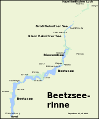
The Riewendsee is a channel lake formed during the Ice Age . It is located in the state of Brandenburg and is part of the city of Brandenburg an der Havel . It represents an exclave . Its western and southern bank areas are in the Potsdam-Mittelmark district and the northeast bank in the Havelland district . To the south, the Riewendsee has a so-called strand connection to the Beetzsee and via this to the Havel . The village of Riewend is on the west bank , Päwesin in the south, directly on the lake.
History of origin
The Riewendsee emerged after the last, the Vistula cold period, in the Beetzseerinne . Inland ice advancing from northeast to southwest and pressurized circulating meltwater formed the channel. After the glacial ice thawed, the basins filled with groundwater and surface water, so that today's chain of several lakes was formed. The channel is interrupted by several channel sleepers, over which flat and narrow connections between the individual pools, the strings, lead between the four southern lake basins. The Riewendsee formed in the fourth lake basin of the channel when viewed from the south. The basin has an elongated course typical of glacial gullies. It is roughly oriented from north to south and has a length of about 2.7 kilometers and a maximum width of about 600 meters. Other lakes in the chain are the Beetzsee south of the Riewendsee and the Klein Behnitzer See and the Groß Behnitzer See in the north. The latter are drained into the Riewendsee via the Klinkgraben . Further trenches in former meltwater channels lead their water to the lake. The name Riewendsee is derived from the village of Riewend, which is located on the west bank of the lake.
Waterway
The Riewendsee belongs to the Beetzsee-Riewendsee waterway . This is another federal waterway along the entire length of the Riewendsee. In the 19th century, the Beetzsee-Riewendsee waterway was of economic importance as a transport route, especially for the adjacent brickworks , which were able to transport their products to Berlin via Riewendsee, Beetzsee and Havel. Today the waterway only plays an important role in sport and recreational shipping.
Swimming tank accident
On August 24, 1965, there was a tragic accident on the Riewendsee. On a warm summer's day, a swimming tank from the National People's Army drove on the lake while children from a nearby holiday camp run by the GDR television station were bathing on the beach. Several children were spontaneously invited to take a ride. During the fourth round, the PT-76 swimming tank with 35 children and carers suddenly sank in the middle of the lake. Seven of the children had a fatal accident.
Protected areas
The Riewendsee is part of several protected areas. For example, it is entirely located in the Westhavelland Nature Park . In addition, he is in the conservation area Westhavelland, European- SPA-area Middle Havelniederung and FFH area Beetzsee channel and lowlands.
Riewend Castle
At the northern end of the Riewendsee, a late Slavic, almost completely preserved, oval castle wall can still be seen, which covers an area of about 0.4 hectares. This is the Riewend castle wall , which as a Wendish prince seat between the 7th and 11th centuries played an important local political role in the area around Brandenburg Castle. Compared to Saaringen or the Reckahn castle wall, for example, Riewend Castle was one of the larger and more important Slavic power centers in the tribal association of the Stodorani (Heveller) .
Individual evidence
- ↑ Sebastian children and Haik Thomas Porada (ed.): Brandenburg an der Havel and surroundings. 2006, p. 243.
- ↑ Those who do not know the past will not understand the present . Accessed May 27, 2014.
- ^ Fire Department Potsdam diving group 1963-1967 . Accessed May 27, 2014.
- ^ Map of the protected areas in the Potsdam-Mittelmark district, sub-area northwest ( memento of August 7, 2011 in the Internet Archive ). Accessed October 16, 2013.

