Klein Behnitzer See
| Klein Behnitzer See | ||
|---|---|---|

|
||
| Geographical location | Nauen, Germany, Brandenburg | |
| Tributaries | Behnitz Klinkgraben | |
| Drain | Behnitz Klinkgraben | |
| Places on the shore | City of Nauen with the Klein Behnitz district | |
| Data | ||
| Coordinates | 52 ° 33 '47 " N , 12 ° 42' 47" E | |
|
|
||
| length | 700 m | |
| width | 200 m | |
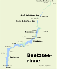
The Klein Behnitzer See is a channel lake formed during the Ice Age . It is located in the state of Brandenburg in the urban area of Nauens in the Havelland district . The inflow and outflow of the lake is the Klinkgraben coming from the Groß Behnitzer lake to the north, which drains the Klein Behnitzer lake to the south to the Riewendsee . On the west bank is the village of Klein Behnitz , after which the lake is named.
History of origin
Like all natural lakes in the area, the Klein Behnitzer See was created after the last, the Vistula cold period . Inland ice advancing from northeast to southwest and pressurized circulating meltwater formed a glacial channel , the Beetzseerinne . After the glacier ice thawed, the basins of the channel filled with ground and surface water, so that today's chain of several lakes was formed. The lake is drained to the Havel via Klinkgraben, Riewendsee and Beetzsee .
Loss of water, silting process
Since the creation of a drainage ditch, the Klinkgraben from Groß Behnitzer See and Klein Behnitzer See to Riewendsee, both have lost significantly in volume and area. The formerly single, elongated lake split into two lakes by the early 19th century at the latest. In the late 18th century, Groß Behnitzer and Klein Behnitzer See were still a coherent body of water. Furthermore, both bodies of water are losing water and area. This process can be seen more clearly in the Klein Behnitzer See, which was still the larger of the two lakes in 1880, but was significantly smaller than the Groß Behnitzer See in the early 21st century. The lost water areas are covered by boggy, swampy soils and an extensive belt of reeds. The former fisherman's house, which was once on the eastern shore of the lake, is now on the silting areas between the two lakes.
Individual evidence
- ^ Friedrich Wilhelm Karl Graf von Schmettau : Schmettausches maps . Second half of the 18th century.
- ^ Prussian measuring table sheet 3442 Tremmen , photo taken in 1880, published in 1882.


