Beetzseerinne
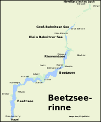
The Beetzseerinne is an Ice Age glacial channel in the west of Brandenburg in Havelland .
morphology
The Beetzseerinne, like the nearby Bohnenland-Görden-Rinne, was created during the last, the Vistula Cold Period , when glacier ice penetrated from the north-east from Scandinavia to Central Europe. Meltwater streams and bodies of dead ice formed the channel under the glacier ice . The length of the Beetzseerinne is about 33 kilometers. As a result, several lake basins were formed in it, which are interrupted by channel sills. The southernmost three lake basins belong to the eponymous Beetzsee . Other lakes in the course are the Riewendsee , the Klein Behnitzer See and the Groß Behnitzer See . To the north of the Groß Behnitzer See there is a small, nameless lake at Sandkrug and some elongated wetlands that belong to the Rinne. Ultimately, she gets lost in the Havelländisches Luch . The elongated lakes typical of a glacial channel drain south-west into the Havel . Another typical feature of glacial gullies is the meander-like course that is pronounced in parts , especially in the second Beetzsee basin . Over its course, the channel changes its rough alignment several times. It runs from the Luch first from northeast to southwest and then more or less to the south over a short distance. The Groß Behnitzer See is again oriented in a south-westerly direction, the Klein Behnitzer See and the Riewendsee to the south and the two northern Beetzsee basins again to the south-west. The southern basin of the Beetzsee again has a north-south axis. Beetzsee and Riewendsee belong to the city of Brandenburg an der Havel , the bank areas in the Rinne to the district of Potsdam-Mittelmark and the Klein and Groß Behnitzer See and the areas north to the Havelländischen Luch to the district of Havelland .
Individual evidence
- ↑ Measurement via Google earth on July 27, 2014.
- ↑ S. Children, HT Porada (ed.): Brandenburg an der Havel and surroundings. 2006, p. 1244.
Coordinates: 52 ° 30 ′ 0 ″ N , 12 ° 40 ′ 48 ″ E
