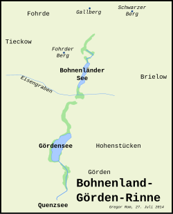
Bohnenland-Görden-Rinne
The Bohnenland-Görden-Rinne or Bohnenlandrinne is an Ice Age glacial channel in the west of Brandenburg in the Havelland .
morphology
Like the nearby Beetzseerinne , the Ice Age Bohnenland-Görden-Görden Gorge, oriented from north to south, arose during the last, the Vistula Glacier , when glacier ice penetrated from the northeast from Scandinavia to Central Europe. At the northern end of the seven and a half kilometer long glacial channel are the two Ice Age compression moraines Schwarzer Berg and Gallberg and immediately beyond the Black Mountain the Marzahner Fenn glacier tongue basin . It starts at about 45 meters above sea level. Meltwater flows and bodies of dead ice formed southwards under the glacial icethe gutter out. It runs in the north over a small sand area , the Bohnenländer Sander. As a result, two lake basins formed in the channel, which are interrupted by a channel threshold. The larger southern of the two channel basins is occupied by the Gördensee , the smaller northern by the Bohnenländer See . There are also several boggy wetlands within the channel. A natural runoff from the lakes and wetlands no longer exists. The Bohnenländer See is drained westward over the Eisengraben to the Havel near Tieckow , the Gördensee southward in the gutter over the Quenzgraben to the Quenzsee . Bohnenländer and Gördensee, like most of the Rinne, belong to the independent city of Brandenburg an der Havel . Only the northern first kilometer is in the Havelsee urban area , in the Potsdam-Mittelmark district .
Individual evidence
- ↑ Measurement via Google earth on July 27, 2014.
- ↑ S. Children, HT Porada (ed.): Brandenburg an der Havel and surroundings. 2006, p. 116.
Coordinates: 52 ° 27 ′ 36 ″ N , 12 ° 30 ′ 0 ″ E
