
Gördensee
| Gördensee or Zummel | ||
|---|---|---|

|
||
| The Gördensee from the east. | ||
| Geographical location | Brandenburg an der Havel , Brandenburg, Germany | |
| Drain | Quenzsee | |
| Data | ||
| Coordinates | 52 ° 26 '3 " N , 12 ° 29' 15" E | |
|
||
| surface | 40 ha | |
| Maximum depth | 2 m | |

The Gördensee or Zummel is located 1.5 km north of the Quenzsee in Brandenburg an der Havel and flows over the Quenzsee into the Havel . It is named after the Görden district. The area of the lake is around 40 hectares and it is a maximum of two meters deep . It extends kidney-shaped, the eastern bank concave , 1.3 km from north to south and in its widest extent from east to west 400 m.
History of origin

The Gördensee is part of a large area of the Görden-Bohnenland-Görden-Görden-Görden-Görden gully , which was formed in the last glacial gully formed by the Vistula glacier . This can be easily followed from the south of the Gallberg and Schwarzen Berg over the Bohnenländer See and Gördensee in a north-south orientation in the topography of the landscape to the Quenzsee . It originated below the Marzahn Glacier Tongue Basin or the Marzahn Fenn and runs parallel to the Beetzseerinne in the east and another channel in the west, in which the Havel flows today . Like its northern Bohnenländer lake, the Gördensee or Zummel is fed by groundwater. Since the creation of a drain, the Quenzgraben and the associated unnatural water loss, the lake has been affected by a pronounced and unnatural silting process. In the late 18th century, the Gördensee was about twice as long north-south and about 50 percent larger water area than at the beginning of the 21st century. Hess describes it as a "dying lake".
Surname
The name Gördensee is the meanwhile consensual name of the lake formerly called Zummel . The term Zummel was only used for the northern, now silted up section of Lake Gördensee. The term Gördensee is derived from the neighboring Brandenburg district of Görden in the east. This in turn takes its name from the Slavic gorne , which Reinhard E. Fischer translates as "above, high-lying settlement" (cf. Polish góra , Russian гора , "mountain").
The word Zummel also refers to the Slavic population of the Mark Brandenburg. Hess, Kinder and Porada translate it with reference to the old Polish word * som , catfish, as a lake in which catfish occur (cf. Polish sum , Russian сом , "catfish").
The lake was first mentioned in 1179 as "Zumit". Eight years later, a medieval document calls it “stagnum Zumit”. In 1842 it is officially recorded as "Zummel" in cartographic works. With the heavy settlement of the Vorwerk Görden, which took its name from the Gorne desert located there , during the industrialization epoch of the early 20th century, the local name Gördensee established itself in the population .
function
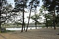
The Gördensee and its wooded surroundings are used as a local recreation area. In summer, its beach in the east is a destination for bathers. In winter, the water is particularly valued by ice sports enthusiasts, as it has no dangerous currents and is also relatively shallow. This means that the ice cover is generally stable earlier and free of dangerous weak zones caused by currents. Sports running disciplines have been held around the Gördensee or Zummel for years. For example, the rbb running club developed into the Gördensee running park with a 6.3 km circuit.
By ordinance of Mayor Dr. Wilhelm Sievers , the channel Gördensee - Bohnenländer See was secured as a landscape protection area (LSG) Bohnenländer See and Gördensee , which is now part of the LSG "Westhavelland". The Gördensee is the scene of an intensive toad migration every year . The animals are protected from traffic on the Anton-Saefkow-Allee, which runs along the southern bank, by means of appropriate guidance systems.
gallery
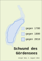
Loss of the lake's water surface
Gördensee in the old town forest

Gördensee in winter as a winter sports area


Drain
The artificial Quenzgraben begins on the southern bank . This drains the lake through the wetlands of the Bohnenland-Görden-Rinne to the Quenzsee. The Gördensee is thus drained to the North Sea via the Havel and Elbe .
See also
Web links
Individual evidence
- ^ A b c Sebastian children, Haik Thomas Porada (ed.): Brandenburg an der Havel and surroundings - a landscape inventory in the area of Brandenburg an der Havel, Pritzerbe, Reckahn and Wusterwitz ; in the series Landscapes in Germany - Values of the German Homeland of the Leibniz Institute for Regional Geography and the Saxon Academy of Sciences in Leipzig, Volume 69, published by Böhlau Verlag Cologne Weimar Vienna, 2006, ISBN 978-3-412-09103-3 , P. 115f.
- ↑ Kulturspiegel No. 11/1960, p. 20f., In the Brandenburg honorary citizen Friedrich-Karl Grasow on the 100th birthday, published by Klaus Heß and Anke Richter on behalf of the Historisches Verein Brandenburg (Havel) e. V. and the city administration of Brandenburg an der Havel, Brandenburg an der Havel 2012, ISBN 978-3-943463-03-3 , pp. 123f.
- ^ Roland Weisse : Contributions to the Weichselkaltzeitlichen morphogens of the Elbhavelwinkel. Series of publications by the Faculty of Mathematics and Natural Sciences at the University of Potsdam, Potsdam April 2003, ISBN 3-935024-73-8 . P. 74, Fig. 4.4.1.
- ^ Friedrich Wilhelm Karl Graf von Schmettau : Schmettausches maps . Second half of the 18th century.
- ↑ Reinhard E. Fischer: The place names of the states of Brandenburg and Berlin. Age - origin - meaning. , be.bra Wissenschaft, Berlin 2005, ISBN 3-937233-17-2 , p. 65
- ↑ Udo Geiseler, Klaus Heß (Hrsg.): Brandenburg an der Havel - Lexikon zur Stadtgeschichte ; on behalf of the Historisches Verein Brandenburg (Havel) e. V., as part of the individual publications of the Brandenburg Historical Commission e. V., Volume XIII, Lukas Verlag, 1st edition 2008, ISBN 978-3-86732-001-6 , p. 132