
Bohnenländer See
| Bohnenländer See | ||
|---|---|---|

|
||
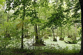
| The Bohnenländer See seen from east to northwest. | ||
| Geographical location | Brandenburg an der Havel , Brandenburg, Germany | |
| Drain | to the iron pit | |
| Data | ||
| Coordinates | 52 ° 27 '40 " N , 12 ° 30' 0" E | |
|
||
| surface | 0.143 km² | |
| length | 1.1 km | |
| width | 0.15 km | |
| Maximum depth | 2 m | |
| Middle deep | 1.2 m | |

The Bohnenländer See is located two kilometers north-northeast of the Gördensee or Zummels in Brandenburg an der Havel and has an outflow into the Havel via the Eisengraben . Like its southern neighbor, it is a pure forest lake. The lake covers an area of around 14.3 hectares and has a maximum water depth of two meters. It stretches 1.1 km from north to south and at its widest extent from east to west 150 m.
History of origin

The Bohnenländer See is part of a glacial gully formed during the last, the Vistula Ice Age, beginning south of the Gallberg and the Black Mountain , and over large areas that have fallen dry . This runs from the southern end of the Marzahn Glacier Tongue Basin or the Marzahn Fenn to the Quenzsee to the south and can be easily followed in the topography of the landscape. It is the Bohnenland-Görden-Rinne , in which the Bohnenland and the Gördensee are located. It is parallel to Beetzsee trough in the east and another channel in the West, which now houses the Havel flows. Like the Gördensee, the Bohnenländer See is also fed by groundwater. Like its southern neighbor, it is affected by a pronounced silting process. The reason for the increasing siltation is the construction of a drain, the iron ditch, which causes the lake to lose water unnaturally.
Surname
The name Bohnenländer See is derived from the Bohnenland Vorwerk , which built the old town of Brandenburg on the desert Görne field before 1684 . Apparently more beans were grown there, so that a document from 1684 speaks of a “Vorwergk bean country”. Bohnenland has been a residential area of the city of Brandenburg an der Havel since the 20th century.
function
Lake Bohnenländer and its wooded surroundings are used as a local recreation area. The almost continuous dense belt of reeds allows only a few places to reach the water surface. A hiking trail of 3.3 kilometers in length circles the lake. While the western bank runs flat into the surrounding area, the eastern bank slope rises up to six meters steeply above the lake shore, sometimes only leaving space for the bank path. Oak, linden, birch, pine and willow are the main trees around the lake. The remnant of beans countries Oak north-northwest east, a former Natural Monument is only about 600 meters distance of the northern Seespitze to a forest Rain, she was one of the thickest oaks in Germany, as well as the 200 meters of the northern Seepitze beginning and about 700 meters to the east withdrawing Sweden walls form together with the lake, the attractions for hikers and walkers in this area.
Fauna, flora
Water lilies and reeds are predominant on the edges. The lake is a favorite area for water birds such as swans , lietzen and mallards . Grass snakes and frogs can be found in the riverside regions .
Broken forest north of the lake
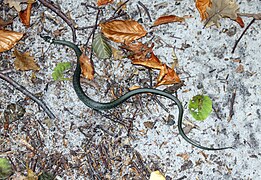
A grass snake near the lake

Broad carpets of water lilies and a thick belt of reeds


Drain
The Bohnenländer See has no tributaries. It is fed by groundwater. The Bohnenländer See drains first in a southerly and then in a westerly direction via an artificial ditch, the Eisengraben, into the Lower Havel near Tieckow . In many maps and books the assumption is made that the Eisengraben is the Schlangengraben in its upper reaches up to the city limits of the Havelsee and forms its extension to the west. According to this assumption, the Schlangengraben would take up the water of the Bohnenländer See and flow off to the east and west. According to these representations, there would be a continuous connection between the Beetzsee and the Havel south of Tieckow via both trenches, but this does not correspond to reality. In fact, the Schlangengraben begins about two kilometers east of the Bohnenländer See, just a hundred meters from the Eisengraben in Butter Laake and flows down to the Beetzsee .
Landscape protection area
By ordinance of Mayor Dr. Wilhelm Sievers , the Gördensee - Bohnenländer See channel was secured as a landscape protection area (LSG), which is now part of the "Westhavelland" LSG.
See also
Web links
Individual evidence
- ↑ a b c Brandenburg an der Havel and surroundings - a landscape inventory in the area of Brandenburg an der Havel, Pritzerbe, Reckahn and Wusterwitz, eds. Sebastian Kinder and Haik Thomas Porada, in the series Landscapes in Germany - Values of the German homeland of Leibniz- Institutes for Regional Geography and the Saxon Academy of Sciences in Leipzig, Volume 69, published by Böhlau Verlag Cologne Weimar Vienna, 2006, ISBN 978-3-412-09103-3 , pp. 116f.
- ↑ Kulturspiegel No. 1/1979, pp. 22-27, in the Brandenburg honorary citizen Friedrich-Karl Grasow on his 100th birthday, published by Klaus Heß and Anke Richter on behalf of the Historisches Verein Brandenburg (Havel) e. V. and the city administration of Brandenburg an der Havel, Brandenburg an der Havel 2012, ISBN 978-3-943463-03-3 , p. 121ff.
- ^ Roland Weisse : Contributions to the Weichselkaltzeitlichen morphogens of the Elbhavelwinkel. Series of publications by the Faculty of Mathematics and Natural Sciences at the University of Potsdam, Potsdam April 2003, ISBN 3-935024-73-8 . P. 74, Fig. 4.4.1.
- ↑ Udo Geiseler, Klaus Heß (Hrsg.): Brandenburg an der Havel - Lexikon zur Stadtgeschichte , on behalf of the Historisches Verein Brandenburg (Havel) e. V., as part of the individual publications of the Brandenburg Historical Commission e. V .; Volume XIII, Lukas Verlag, 1st edition 2008, ISBN 978-3-86732-001-6 , p. 51
- ^ Sebastian children (ed.): Brandenburg an der Havel and surroundings. 2006, p. 102.
- ↑ PortalU maps with official waterway maps ( Memento of the original from December 28, 2013 in the Internet Archive ) Info: The archive link was automatically inserted and not yet checked. Please check the original and archive link according to the instructions and then remove this notice. . Accessed December 26, 2013