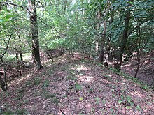
Sweden walls
The Schwedenwwall or Schwedenschanzen are a late medieval or early modern defensive structure in the city of Brandenburg an der Havel and the municipality of Beetzsee . They are protected as a ground monument.
History of origin
There are different statements about the origin of the Schwedenwwall, which was built as a 30 meter wide and about one kilometer long defense between the northern Bohnenländer See and the Grönschen Bruch Brielow. The two ramparts and three trenches from the old town of Brandenburg were built for the Landwehr and later popularly named with their current name in the course of the Thirty Years War . Other sources ascribe the complex directly to the Swedes, who occupied the area during the Thirty Years War and the Swedish invasion of 1674/75 .
Flora Fauna
Today the Schwedenwwall lies as naturally wooded elevations in the old town forest. They are overgrown with a rich flora and are inhabited by a variety of animals. There are oaks , mountain ash , buckthorn , bird cherry , hazelnut , hawthorn , hornbeam , birch , pine , rowan berries and other tree and shrub species. Species such as lily of the valley , cowslips , buttercups , meadow sage , pechnelke and grove quail wheat grow on the ground .
Protected areas
The Swedish walls are under the name "Landwehr German Middle Ages" in the country's list of monuments. In addition, they are placed under protection as a protected biotope . They are still in Westhavelland Nature Park and conservation area Westhavelland.
Individual evidence
- ↑ Brandenburg State Office for Monument Preservation and State Archaeological Museum (ed.): List of monuments of the State of Brandenburg - City of Brandenburg an der Havel . A) Ground monuments, ground monument number 4106, December 31, 2018, p. 3 ( bldam-brandenburg.de [PDF; 201 kB ; accessed on May 13, 2019]).
- ↑ a b c Sebastian children and Haik Thomas Porada (ed.): Brandenburg an der Havel and surroundings. 2006, p. 154, ISBN 978-3-412-09103-3 .
- ↑ a b c Photo by Gregor Rom: Municipal information board Die Schwedenwwall , January 2014.
- ↑ Part sheet Northwest Protected Areas. (PDF) In: Landkreis Potsdam-Mittelmark landscape framework plan. Office for Environmental and Landscape Planning, archived from the original on August 7, 2011 ; Retrieved October 16, 2013 .
Coordinates: 52 ° 27 ′ 53.6 ″ N , 12 ° 30 ′ 36 ″ E

