
Mill mountains
| coat of arms | Germany map | |
|---|---|---|

|
Coordinates: 52 ° 40 ′ N , 12 ° 37 ′ E |
|
| Basic data | ||
| State : | Brandenburg | |
| County : | Havelland | |
| Office : | Friesack | |
| Height : | 42 m above sea level NHN | |
| Area : | 39.62 km 2 | |
| Residents: | 723 (Dec. 31, 2019) | |
| Population density : | 18 inhabitants per km 2 | |
| Postal code : | 14662 | |
| Primaries : | 033237, 033238 | |
| License plate : | HVL, NAU, RN | |
| Community key : | 12 0 63 202 | |
| Community structure: | 3 districts | |
| Office administration address: | Marktstrasse 22 14662 Friesack |
|
| Website : | ||
| Mayor : | Matthias Rehder | |
| Location of the municipality of Mühlenberge in the Havelland district | ||
  |
||


Mühlenberge is a municipality in the north of the Havelland district in Brandenburg . It belongs to the Friesack office with its seat in Friesack .
geography
Mühlenberge is about 60 km northwest of Berlin on the eastern edge of up to 77 meters above sea level. NHN high country Friesack and west of the Great Havelland main canal . Mühlenberge is centrally located between the cities of Rathenow , Nauen , Kyritz and Neuruppin .
Community structure
Mühlenberge consists of the districts Haage , Senzke and Wagenitz as well as the residential area Karlsaue.
history
The district of Haage was first mentioned in a document in 1307.
Haage, Senzke and Wagenitz belonged to the Westhavelland district in the Prussian province of Brandenburg since 1817 and to the Nauen district in the GDR district of Potsdam from 1952 . Since 1993, the places have been in the Havelland district in Brandenburg.
The community of Mühlenberge was created on December 31, 2002 from the voluntary merger of the previously independent communities of Haage, Senzke and Wagenitz.
Population development
| year | Haage | Senzke | Wagenitz | year | Mill mountains | year | Mill mountains | ||
|---|---|---|---|---|---|---|---|---|---|
| 1875 | 483 | 250 | 365 | 2002 | 819 | 2015 | 720 | ||
| 1910 | 431 | 283 | 370 | 2005 | 792 | 2016 | 711 | ||
| 1939 | 374 | 225 | 315 | 2010 | 755 | 2017 | 711 | ||
| 1946 | 601 | 472 | 522 | 2011 | 729 | 2018 | 720 | ||
| 1950 | 628 | 457 | 580 | 2012 | 736 | 2019 | 723 | ||
| 1971 | 353 | 341 | 394 | 2013 | 710 | ||||
| 1990 | 284 | 299 | 343 | 2014 | 726 | ||||
| 1995 | 262 | 265 | 331 | ||||||
| 2000 | 272 | 273 | 330 | ||||||
| 2001 | 259 | 252 | 314 |
Territory of the respective year, number of inhabitants: as of December 31 (from 1991), from 2011 based on the 2011 census
politics
Community representation
The Mühlenberge municipal council consists of ten members and the honorary mayor.
| Party / group of voters | Seats |
|---|---|
| Mühlenberge Voters Union (WUM) | 7th |
| Mühlenberge Citizens' Alliance (BBM) | 2 |
| SPD | 1 |
(As of: local election on May 26, 2019)
mayor
- 2003–2014: Hendrik Frost
- since 2014: Matthias Rehder (Mühlenberge Voters Union)
Rehder was elected in the mayoral election on May 26, 2019 with 69.6% of the valid votes for a further five-year term.
Attractions
The list of monuments in Mühlenberge includes the monuments entered in the list of monuments of the state of Brandenburg, including
- Church in Haage from the 17th century with lavish interior fittings made of dark oak (originally in the village church of Döberitz)
- Church in Senzke from the 17th century with peasant painting and apse based on Schinkel's model
- Church in Wagenitz from the 17th century with votive painting from Chr. Bredow from 1664
- Sweden Tower in Wagenitz

Church in Haage
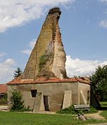
Sweden Tower in Wagenitz

Church in Wagenitz

Church in Senzke


traffic
The federal highway 5 runs through the municipality between Friesack and Nauen .
The nearest train stations are Friesack (Mark) and Paulinenaue on the Berlin – Hamburg line . They are served by the regional express line RE 2 Wismar – Berlin – Cottbus.
Personalities
- Joachim Heinrich Fintelmann (–1752), manorial gardener on the Senzke estate
- Asmus Ehrenreich von Bredow (1693–1756), Prussian lieutenant general, born in Senzke
- Carl Friedrich Fintelmann (1738–1811), court gardener, born in Senzke
- Joachim von Bredow (1867–1941), landowner in Wagenitz
- Bernhard von Derschau (1903–1945), district administrator, born in Wagenitz
- Friedrich Höricke (* 1963), pianist and composer, lives in Senzke
For centuries, members of the von Bredow family exerted influence on the fate of today's districts of the community.
Individual evidence
- ↑ Population in the State of Brandenburg according to municipalities, offices and municipalities not subject to official registration on December 31, 2019 (XLSX file; 223 KB) (updated official population figures) ( help on this ).
- ^ Service portal of the state administration Brandenburg. Mühlenberge community
- ↑ StBA: Changes in the municipalities in Germany, see 2002
- ^ Historical municipality register of the state of Brandenburg 1875 to 2005. District Havelland . Pp. 18-21
- ↑ Population in the state of Brandenburg from 1991 to 2015 according to independent cities, districts and municipalities , Table 7
- ^ Office for Statistics Berlin-Brandenburg (Ed.): Statistical report AI 7, A II 3, A III 3. Population development and population status in the state of Brandenburg (respective editions of the month of December)
- ^ Result of the local election on May 26, 2019
- ↑ Local elections October 26, 2003. Mayoral elections , p. 25
- ^ Result of the mayoral election on May 25, 2014
- ↑ Section 73 of the Brandenburg Local Election Act
- ^ Result of the mayoral election on May 26, 2019
Web links
Brieselang | Dallgow-Döberitz | Falkensee | Friesack | Gollenberg | Big show | Havelaue | Ketzin / Havel | Kleßen-Görne | Throw up | Märkisch Luch | Milower Land | Mill mountains | Nauen | Nennhausen | Paulinenaue | Pessin | Premnitz | Rathenow | Retzow | Rhinow | Schönwalde-Glien | Lake view | Stechow-Ferchesar | Meadow meadow | Wustermark