Hoenow
|
Hoenow
Hoppegarten municipality
|
|
|---|---|
| Coordinates: 52 ° 32 ′ 54 ″ N , 13 ° 38 ′ 16 ″ E | |
| Height : | 61 m above sea level NN |
| Area : | 13.39 km² |
| Residents : | 12,000 (2018) |
| Population density : | 896 inhabitants / km² |
| Incorporation : | October 26, 2003 |
| Postal code : | 15366 |
| Primaries : | 03342, 030 |
Since October 26, 2003, Hönow [ 'hø einnoː ] has been part of the non-governmental municipality of Hoppegarten in the Märkisch-Oderland district in Brandenburg with 12,000 inhabitants.
geography
Hönow is located on the north-eastern city limits of Berlin just below the Barnim plateau . The village borders in the west on the Berlin district of Hellersdorf , in the south on the district Mahlsdorf, which also belongs to the Berlin district of Marzahn-Hellersdorf, and in the southeast on Neuenhagen near Berlin .
landscape
Hönow's landscape is mainly characterized by the areas used for agricultural purposes. Hönow also has its own forest, which is officially called Herrendike, but is usually only referred to as Hönow Forest.
In the southeast, the Zochegraben , or Zoche, separates Hönow from Neuenhagen. It flows in a wide valley, but has a very narrow river.
In the north is the narrow lake, which is fed by a small stream that is mostly dry in summer. A brook , which is also dry in summer, leads from it into the Retsee , which is the largest of the Hönower lakes with around 8 hectares. This was originally fed by a small ditch that goes through the Herrendike and comes from the Steinhöfelsee. Another stream leads from the Retsee into the Haussee, which is located immediately west of the village center. This is about 7.5 hectares. Both lakes used to be called 1st, 2nd and 3rd because the Retsee can be literally divided into two different lakes. (see Google Maps) From the Haussee the brook leads into the Hönower Weiherkette where it becomes the Hellersdorfer Graben.
Districts
Hönow village
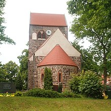
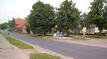
The district around by an Anger divided village street (GDR era road of friendship ) has retained its village character to some extent. This is where Hönow's oldest building is located, the late Romanesque village church built in the Middle Ages . The former count's castle with a small castle park was located directly below the village church. After the Second World War, the destroyed castle was not rebuilt.
Hönow-North
The two settlements north of the village, one and a half kilometers away, also belong to Hönow. In the parcel closest to the village, the Wöhrdetal, the merchant and tea merchant Friedrich Glücks settled down in the 19th century. His lucky tea brought him enough money to build a hunting lodge on his approximately 20,000 m² property in 1900 - the Glücksburg . The building had an imposing dome , a terrace and a wide flight of stairs. Friedrich Glücks was probably also one of the first settlers in this piece of land outside the village, which was only sparsely populated around 1932.
After the Second World War , the Glücks family was initially expropriated as part of the land reform and the Fisch family got the property. The name Glücksburg was deleted from maps and other documents, but remained popular. The settlements north of the village appeared on the maps under the name Hönow-Nord . The Fischs had to vacate the Glücksburg area from 1960 when the State Security wanted to set up a vacation and training center here.
In addition to the main building, which was heavily rebuilt over the decades, which was hardly recognizable as a hunting lodge in the 1970s, there are still several small buildings on the property that were used commercially after 1989. Behind the buildings there is an overgrown forest and lake landscape.
500 meters north of the former Glücksburg there is another settlement called Am Schleipfuhl in the direction of Mehrow - named after a pond on Mehrower Straße.
Hönow settlement expansion
The expansion of the Hönow settlement has its origins in the development of fallow arable land in the mid-1990s. Gradually, terraced , double and single-family houses as well as multi-storey modern residential complexes were built . A green corridor was created within the settlement expansion, which is criss-crossed with small pools, long walking paths and a few playgrounds. This is a kind of extension to the Hönower Weiherkette nature reserve , which was incorporated into the Hellersdorf district during the settlement expansion of Berlin in the 1980s. In addition, three day-care centers and two additional supermarket complexes were built. Smaller businesses in the basement of the residential complexes and a recycling yard complement the infrastructure in addition to an existing local transport connection to the local Hönow underground station. Since spring 2018, the Grimm Brothers Primary School has been building a new school in Schulstrasse east of the green corridor. In addition, a new community center for Hönow is being built on Brandenburgische Strasse.
Hönow settlement
In the mid-1980s the district of Hellersdorf was expanded from Berlin to the east. New buildings were erected in an area that belonged to Hönow. The former city limits can still be seen today. The area from Berliner Strasse in the north, between Zerbster and Weißenfelser Strasse, between Lichtenhainer and Schönewalder Strasse, via Riesaer Strasse to Döbelner / Waldheimer Strasse and the Kaulsdorf border is characterized by public buildings and green spaces, but few residential buildings. Since it was incorporated into the city of Berlin on October 3, 1990, the official area name has been Berlin-Hellersdorf Hönow-West. Ecclesiastically, the area is still part of Hönow. The Grimm Brothers Primary School is also located in this area. It was built during the GDR, which gives it a school style typical of the GDR. The Hönower shopping arcades, or HEP for short, are also located in this area, and are located between the underground station and the primary school.
history

Originally Hönow was probably settled by the Wends . In the 13th century, the Ascanian margraves Johann I and Otto III built. allegedly a settlement here, which was first mentioned in the land register of Charles IV in the years 1375–77 . Recent studies indicate that the Wettins under Heinrich the Illustrious Hönow wanted to develop into a small rule against the Ascanian brothers who ruled together during the state development phase in the first half of the 13th century. Probably only with the Teltow War (see there) between 1239 and 1245 Hönow finally and permanently came to the Mark Brandenburg .
The place was destroyed during the Hussite Wars in 1432 and the Thirty Years' War in the early 17th century. The Hönower "Schloss" was badly damaged in World War II and demolished after the war. In fact, the castle was commissioned by Friedrich Anton Dotti (1858–1923), who had acquired several Hönower farm estates, based on a design by the architects Hermann Solf (1856–1909) and Franz Wichards (1856–1919) at the end of the 19th century manor house. Dotti's brother Georg Leopold (1852-1915) had a similar manor house built in nearby Neuenhagen by Solf and Wichards' office. The late Romanesque church is the only older building that has survived.
Initially, the people of Hönow lived from agriculture . Only at the beginning of the 19th century did the craft slowly develop here. In 1953 an LPG was founded, which took over the management of a large part of the agricultural land. In addition, Hönow developed into an excursion destination, especially from Berlin.
Since around 1995, new housing estates have been built in and around Hönow with the development of fallow agricultural land, combined with a considerable increase in the number of residents. In the medium term, Hönow is expected to have a population of around 12,000, most of which will populate the area of settlement expansion.
2006 Hönow celebrated the 775th anniversary of its existence.
Population development
|
|
|
|
|
Territory of the respective year
traffic
Subway station
In the direct vicinity of the Hönow settlement, the Hönow subway station was opened on July 1, 1989 , and was reunified from Hönow to Berlin on October 3, 1990 as part of German reunification . As overground situated terminus of eastern Metro Station is Berlin underground , the terminus of the metro line U5 . It is the highest above-ground underground station in Berlin (approx. 53 m above sea level ) and has three tracks located on a central and a side platform . To the west of the station there is an extensive parking facility for underground trains, which is only partially used by the Berliner Verkehrsbetriebe (BVG).
Road traffic
The most important traffic axis of the place is the Berliner Straße / Altlandsberger Allee. It connects Hönow with Berlin ( Marzahn-Hellersdorf district ), as well as with the federal motorway 10 ( Berlin-Marzahn junction ). The Hönower settlement can be reached via several large streets, including Mahlsdorfer Strasse or Neuenhagener Chaussee. Hönow Dorf and Hönow Nord can be reached via Dorfstraße, later Mehrower Straße.
Transportation
Several bus routes operate in Hönow , including the BVG bus route 395 in Berlin . In addition to the two Brandenburg bus lines 941 and 943, the N5 bus line also operates at night as a night bus for the U5 underground line and connects the west of the Hönow settlement.
The Berlin tram lines M6 and 18 end immediately before the border with Hönow. You can continue your journey with the 395 bus.
Cycle tourism
The Hönow underground station is the starting point of the long- distance cycle route ZR1, a feeder to the European cycle route R1 , which runs over 3500 kilometers from Boulogne-sur-Mer in France through Berlin to Saint Petersburg in Russia . A newly developed section of the ZR1, almost three kilometers long, was officially opened on December 13, 2007 and leads behind the village center of Hönow over the Schwarzen Weg and the Rote Weg to Altlandsberg .
Public facilities
Hönow is the headquarters of the social insurance office for agriculture, forestry and horticulture for the states of Berlin, Brandenburg, Mecklenburg-Western Pomerania, Saxony-Anhalt, Saxony and Thuringia.
Personalities
- Edwin Werckmeister (1832–1912), Lieutenant General, born in Hönow
- Ulrich Voß (* 1938), actor, lives in the village center
Say
Two legends that were published in the 19th century refer to the hill called Blocksberg in the village and to the Hönower heraldic animal, the turtle.
Web links
- Brief description of Hönow (PDF; 9 kB) from the municipality of Hoppegarten
- Romanesque routes in Berlin and Brandenburg - Hönow village church
Individual evidence
- ↑ Municipalities 1994 and their changes since January 1, 1948 in the new federal states , Metzler-Poeschel publishing house, Stuttgart, 1995, ISBN 3-8246-0321-7 , publisher: Federal Statistical Office
- ↑ O. Meyer: The village of Hönow - his brief history. In: Heimat und Welt 50/1938 and 1/1939. ( online ( Memento from January 4, 2008 in the Internet Archive ))
- ↑ http://www.maerkische-landsitze.de/lexikon.htm#Dotti_Friedrich . A drawing of the mansion can be found in the Berliner Architekturwelt from 1899, p. 79: https://digital.zlb.de/viewer/readingmode/14192916_1899/82/
- ^ Historical municipality register of the state of Brandenburg 1875 to 2005. Landkreis Märkisch-Oderland . Pp. 22-25
- ^ Social insurance for agriculture, forestry and horticulture
- ↑ Adalbert Kuhn: The Blocksberg and the turtle zu Hönow. In: Märkische sagas and fairy tales. ( Online , public domain text)


