Retsee
| Retsee | ||
|---|---|---|

|
||
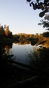
| Retsee on the banks of Hönow-Nord | ||
| Geographical location | District of Märkisch-Oderland , Brandenburg , Germany | |
| Tributaries | Brook starting from Schmalen See (Südbarnimer Weiherkette); Brook starting from Steinhövelsee ( Mehrow ) | |
| Drain | underground connection to the Haussee → Hellersdorfer Graben → Wuhle → Spree → Havel → Elbe → North Sea | |
| Places on the shore | Hoenow | |
| Data | ||
| Coordinates | 52 ° 33 '11 " N , 13 ° 37' 47" E | |
|
|
||
| surface | 7.83 ha | |
| scope | 2.53 km | |
| Maximum depth | 2.3 m | |
| Middle deep | 1.5 m | |
The Retsee is a medium-sized lake in the Märkisch-Oder-Land, which is located just below the plateau of the Barnims.
It is part of the village of Hönow and is its largest lake.
Geographical location
The Retsee lies at the lower end of the Barnim, but still extends a little way into it. At its northern end is the Herrendike forest . It can be recognized by a headland split in the middle. The two parts are connected by a natural canal . At its southern end, the Eicher Weg separates the Haussee from the Retsee. The Haussee lies west of the Hönower village center and north of the Hönower Weiherkette .
The Retsee is Hönow's cleanest lake. The water is quite clear right on the bank. The lake is particularly suitable for fishing. The southern part of the lake is cleaner than the northern part, which is shallower and more muddy.

