Eschengraben
| Eschengraben | ||
|
Eschengraben - View towards Berliner Straße |
||
| Data | ||
| location | Berlin , Germany | |
| River system | Elbe | |
| Drain over | Panke → Berlin-Spandauer Schifffahrtskanal → Havel → Elbe → North Sea | |
| source | near Prenzlauer Promenade / Thulestraße 52 ° 33 '23 " N , 13 ° 25' 42" O |
|
| Source height | 54 m above sea level NN | |
| muzzle | in the Panke coordinates: 52 ° 33 '54 " N , 13 ° 23' 13" E 52 ° 33 '54 " N , 13 ° 23' 13" E |
|
| Mouth height | 32 m above sea level NN | |
| Height difference | 22 m | |
| Bottom slope | 6.7 ‰ | |
| length | 3.3 km | |
| Big cities | Berlin | |
The ash pit was a watercourse in the district of Pankow of the same name Berlin Pankow district . It flowed into the Panke , a tributary of the Spree . It got its name from the ash tree .
course
"Eschengraben, emerges from the Panke between the Luisenbade and Schönholz, cuts through the Schönhauser Allee at the Chausseehaus and gets lost on the Chaussee leading to Franz. Buchholz, where the path to Heinersdorf starts."
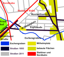
The course can still be determined on maps from before 1900. The source was located near Thulestrasse, roughly in the area of today's building materials store. After 100 meters northwards, there is a right-angled bend to the west, a little more south than today's Hallandstraße , i.e. not congruent with today's street Am Eschengraben . The Berliner Straße flows through 70 meters south of the esplanade in a south-westerly direction. In the adjoining allotment garden Bornholm II, remains of the ash ditch can still be seen. At a distance of 750 meters from Berliner Straße, the esplanade crosses to the northwest. The Eschengraben then crosses the lines of the Stettiner Bahn and the Berlin Northern Railway in the southern part of the Feuchten Winkel . The burial place of the Sophiengemeinde and the Elisabethgemeinde is bordered to the north by the river. The Eschengraben flowed into the Panke in the course of today's Gottschalkstrasse .
history
Until the end of the 19th century, the Eschengraben still flowed through a natural landscape.
The ash pit formed late 19th century for its part the precincts limit (ie city limits) of Berlin. The area between the rural community of Pankow and Berlin was developed for residential buildings before the beginning of the First World War. The course of the Eschengraben was removed except for a remaining run in what is now the colony south of the esplanade. Part of its course is only marked by the street of the same name. The confluence of the Eschengraben in the Panke was once at the level of today's Pankebeck, further north of Cemetery III of the French community, west of Wollankstrasse and Gottschalkstrasse. The river originally drew water from the area west of the White Lake.
When the site was being developed as a residential area, a street nearby was named after him on November 26, 1925. It runs from Berliner Strasse to Elsa-Brändström-Strasse . The architect Erwin Anton Gutkind built the listed residential complex “Am Eschengraben” here on behalf of the “German Garden City Society” from 1925 to 1927. This ensemble was built according to the principles of New Building and has the character of a monument.
The school buildings of today's 5th and 6th primary school in Pankow and the facilities of the former Willner wheat beer brewery are located on the street , both of which are listed buildings .
Web links
- Eschengraben. In: Street name lexicon of the Luisenstädtischer Bildungsverein (near Kaupert )
- Description of the residential complex
Individual evidence
- ↑ FIS-Broker map display Digital topographic map 1: 10 000 (DTK10)
- ^ Supplement to the Berlin address book 1893 . Plan with all suburbs and complete city and ring railways. Edited and edited by Julius Straube .
- ^ JGA Ludwig Helling (ed.): History-statistical-topographical pocket book of Berlin and its immediate surroundings. HAW Logier, Berlin 1830. Page 84 Online at google.com/books
- ^ Supplement to the Berlin address book 1893 . Plan with all suburbs and complete city and ring railways. Edited and edited by Julius Straube.
- ↑ Coordinates of the former headwaters
- ↑ Coordinates of the mouth
- ^ Supplement to the Berlin address book 1893, plan of Berlin with all suburbs and complete city and ring railways, edited and edited by Julius Straube. Geographical Institute and Map Publisher, Julius Straube, Berlin SW, Gitschinerstraße 109
- ↑ Prussian original table sheet, sheet 1837 Sect. Berlin, Volume VI, Sheet I. Taken and drawn in 1825 by the engineer-geographer Glasses, SBB N 729/1
- ↑ Entry in the Berlin State Monument List
- ↑ Entry in the Berlin State Monument List
- ↑ Entry in the Berlin State Monument List

