
Kietz (Berlin-Koepenick)

The Kietz was originally a Slavic fishing settlement southeast of the center of the Berlin district of Köpenick , today part of the Treptow-Köpenick district , which retained its autonomy under local law until the end of the 19th century (self-administration). According to city law, its population was neither among the residents of the castle and the later Köpenick Castle nor among the residents of the city of Köpenick.
In the cityscape of the street of the same name, an essentially closed ensemble of buildings from the 18th and 19th centuries, which is a listed building, has been preserved .
location
The Kietz is located on the east bank of the Dahme south of Müggelheimer Straße. Across from the Kietz is the Köpenick Castle on an island in the Dahme, to the north of which is the Köpenick old town. The old town island and the Kietz are separated by the Kietzer Graben. The Kietz consists of the street of the same name, which leads south from Müggelheimer Straße towards Wendenschloss , the parallel Gartenstraße and a few short connecting streets .
history

Since the 7th century there has been a Slavic castle on the site of today's Köpenick Castle.
The Kietz Köpenick probably originated in the 13th century. Around 1240 the Ascanians built a new castle. The Slavs were resettled from the island. Some of them were settled on the east bank of the Dahme in order to form a typical Kietz for that time as a service settlement for a German castle on the castle island. Above all, the inhabitants had to supply the new margraves' castle with fish. The oldest documented mention of the Kietz comes from the year 1355. According to the land book of Emperor Charles IV of 1375, there were 24 houses in Vicus qui dicitur Kytz . Called "vicus Kytz". The inhabitants lived mainly from fishing. The alley village was described in 1387 as "The Wends on the Kietz near Köpenick". Before 1487, 21 heirs were occupied, three were desolate . They performed bait services opposite the castle and had the right to fish “in the waters of Köpenick Castle”, so they were entitled to fish there. From the year 1516 the "Kietzern" was reported succinctly. In 1577 there was one Schulzen and 29 Kietzer. The register of inheritance from 1589 listed 31 house locations in the Kietz, all of which had fishing rights. So that the residents on the east side of the road turned away from the river could also fish, waterways were created on their properties. The Kietz included larger meadows that were widely scattered over the surrounding area, but no arable land.
The Kietz was partially destroyed in the Thirty Years War and later rebuilt in its old structure. In 1652 there was a Schulzen, 23 heretics with two sons and a servant. In 1704 there were already 28 kietzers living next to Schulzen, only two estates were still desolate. A certificate this year indicated the special way of life of not having your own arable land. There it was said that the Kietz had "no field", but "only a small garden and some meadows on the streams". The size of the Kietz changed little for centuries. 31 residential buildings were also counted in 1743, and only six were added in the following hundred years.
In 1801 there were fishermen's dwellings "which are, however, included in the city". There are "some 30 hosts who call themselves neighbors". In 1840 the settlement had grown to 37 houses; the population increased to 415 people by 1858. Initially, the houses were located exclusively on the street leading along the Dahme (today the street 'Kietz'), later craftsmen and tradespeople also settled on a parallel street (today's 'Gartenstraße'). This year there was the fishing village with the Müggelbude establishment. A total of 31 fishermen lived there with 21 assistants and 55 workers. There were 31 properties, but they were all comparatively small. The largest was only 45 acres. 12 more were 87 acres together, 18 under five acres (63 acres together). In the meantime, some trades had also settled. There was a master baker with two journeymen, a master shoemaker, a victim dealer and a reindeer (renter). In 1860 there was one public, 37 residential and 12 farm buildings.
In the second half of the 19th century, a number of industrial companies opened on the east bank of the Dahme. In addition, a residential area was built next to the Kietz, the Kietz suburb . Several multi-storey residential buildings were also built in the Kietz itself. On April 1, 1898, the Kietz was incorporated into Köpenick.
In 1920 Köpenick and with it the Kietz became part of Greater Berlin . In 1993 the Berlin Senate declared the Kietz, together with the old town of Köpenick, a redevelopment area. In the years that followed, many buildings were refurbished in accordance with listed buildings.
Development
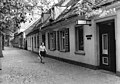
The Kietz - in terms of its layout a street village - has today largely merged with the Köpenick development, but a largely closed ensemble of buildings from the 18th and 19th centuries has been preserved , especially in the Kietz street . The house Kietz 27 still shows a large part of the original substance from the year 1727. The house Kietz 21 dates from the last quarter of the 18th century. Some other houses such as Kietz 19 are essentially also from the beginning of the 18th century, but some have been rebuilt several times since then. The older fishermen's houses are single-storey with saddle roofs , newer buildings have two and three storeys, in Gartenstrasse and in a few places in Strasse Kietz there are several multi-storey houses from the Wilhelminian era . The ensemble of buildings is completely listed, and a number of houses are listed as individual monuments.

Around 1910
In 1976
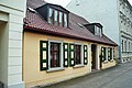
Kietz 8 in 2006

Kietz 25 in 2011


literature
- Herbert Ludat : The East German Kietze . Publishing house Gustav Kunze, Bernburg 1936, DNB 574915672 .
- Johannes Schultze (Hrsg.): The land book of the Mark Brandenburg of 1375 (= Brandenburg land books . Volume 2; publications of the historical commission for the province of Brandenburg and the imperial capital Berlin . Volume VIII, 2). Commission publisher von Gsellius, Berlin 1940 ( digitized in Potsdam University Library ).
- Bruno Krüger (author), H. Schneemann (cartography): The Kietz settlements in northern Central Europe. Contributions of archeology to their age determination and essence interpretation . With 3 distribution maps in the appendix (= German Academy of Sciences in Berlin [Hrsg.]: Writings of the Section for Pre- and Early History . Volume 11). Akademie-Verlag, Berlin 1962, DNB 452605652 .
- Hans-Jürgen Rach: The villages in Berlin. A handbook of the former rural communities in the urban area of Berlin . Ed .: Cultural history / folklore science department in the Central Institute for History of the Academy of Sciences of the GDR. 2nd, revised edition. Verlag für Bauwesen, Berlin 1990, ISBN 3-345-00243-4 , Kietz bei Köpenick. City district Köpenick, S. 155-157 .
- Lieselott Enders : Historical local lexicon for Brandenburg: Teltow (= Historical local lexicon for Brandenburg . Volume 4). Verlag Hermann Böhlaus successor, Weimar 1976.
Web links
- Kietz. In: Street name lexicon of the Luisenstädtischer Bildungsverein (near Kaupert )
- The Kietz near Köpenick and the fishing on the pages of the Köpenick fishing association
- Kietz village complex on the website of the Treptow-Köpenick district office
- Entry in the Berlin State Monument List: Kietz 3–28, Kietz village complex
Individual evidence
- ↑ Johannes Schultze (ed.): The land book of the Mark Brandenburg from 1375 . Commission publisher von Gsellius, Berlin 1940, [Die Burgen]. De castrἱs super Teltow. Copenick. Kytz, S. 38 .
- ↑ Köpenicker Fischervereinigung, Der Kietz bei Köpenick und die Fischerei , accessed on October 25, 2010
- ^ Hans-Jürgen Rach: The villages in Berlin. A handbook of the former rural communities of Berlin. VEB Verlag für Bauwesen, Berlin 1988, ISBN 3-345-00243-4 , pp. 155–157
- ^ Ninth ordinance on the formal definition of redevelopment areas (PDF; 1.1 MB) of September 21, 1993
- ^ Georg Dehio: Handbook of German Art Monuments, Berlin . Deutscher Kunstverlag 2006, ISBN 3-422-03111-1 , p. 550
- ↑ Entry in the Berlin State Monument List
Coordinates: 52 ° 27 ' N , 13 ° 35' E