
Döberitz military training area

The Döberitz military training area , also known as Döberitz Army School , was an important military training area near Dallgow-Döberitz , west of Berlin in Brandenburg . Döberitz was one of the largest practice areas in Germany. The area was used for more than 300 years until 1992 by the Prussian army , the Reichswehr and the Wehrmacht, as well as the Soviet occupation forces . The site was used for army training, for NCO and officer training ( Döberitz Infantry School ) and for the training of pilots (from 1910, at that time as the Döberitz flying school of the Royal Prussian Air Force), for testing new aircraft and in the 1930s as a training ground for Motor vehicles (Reichsmotorsportschule).
history
The Döberitzer Heide area , which was still wooded until 1896, was used as a military maneuvering area for around 300 years until 1992. It only became a military training area in 1896. It was located west of Berlin in Havelland between Dallgow in the north, Krampnitz in the south, Priort in the west and Seeburg in the east. In this area, some regiments of King Frederick I have been trained in practical warfare. The first military use of the area around the village of Döberitz was recorded in 1713 under Friedrich Wilhelm I. In September 1753, under Frederick II, a first major maneuver followed there, which was misrepresented in the literature during the Seven Years' War to mislead foreign countries and was carried out with 44,000 soldiers.
Until 1890, the Berlin and Potsdam troops carried out target practice on the shooting range in Tegel . Because of the deficiencies of the place, the Prussian army command demanded a permanent training ground. The then chief of the General Staff of the Guard Corps decided on the area around Döberitz. In 1892 the then General Staff Officer von Bredow was given the task of inspecting the site and defining the borders. The land surveys and negotiations between the military treasury and the affected communities began in 1893, and by 1894 the military treasury had requisitioned the area of approximately 4400 hectares around Döberitz.
After the purchase negotiations were over, three quarters of the wooded area was cleared. Part of the resulting wood was used for the construction of the officers' mess, the barracks and the stables of the guard camp. This was done with a view to the expected deployment of troops in colonies (e.g. the Boxer Rebellion in China ) to simulate steppe-like and desert-like geographies. Since 1895 the permanent establishment took place through the establishment and construction of a commandant's office and the garrison administration. The original location of the headquarters was in Spandau until 1910 and was only relocated to Döberitz in the summer months - when the exercises were being carried out.

The military training area was named after the former village of Döberitz, which was located in the middle of the square. In 1895 the village of Döberitz was evacuated from its last inhabitants. After the evacuation, the watch and work detachment moved into the buildings in the village. In the presence of Kaiser Wilhelm II , the Döberitz military training area and the guard camp were opened for use on April 1, 1895. The square initially served as a training area for the guard corps . In the first decade of the 20th century, the Heerstraße (today's B 5 ) was expanded upon military demand . This served as a direct connection between Berlin and the military training area. In 1901, the field airmen of the airship troops received the first airship battalion .
From 1910, the Döberitz airfield was laid out with a flying school, which was to become important for the first military flight use in Germany. Initially no part of the armed forces of its own , it was under the army until 1916 . Döberitz is thus the place of origin of the German air force .


At the beginning of the First World War , a provisional prisoner-of-war camp was set up on the western edge of the camp , which was expanded from 1915 to two camps at Rohrbeck and Dyrotz that were newly built by prisoners of war . In total, more than 30,000 prisoners from seven nations were interned there by October 1918.
After the First World War, the Reichswehr , associations of the Black Reichswehr and nationalist military associations used the training area and its facilities.
In November 1919, was Freikorps - Ehrhardt Brigade from Upper Silesia to the camp Döberitz laid. In March 1920 the order was issued to disband the brigade. Their leaders - determined to oppose the dissolution - appealed to General Walther von Lüttwitz in Berlin. Lüttwitz, one of the organizers of the Freikorps in 1918 and 1919, turned to Reich President Friedrich Ebert and Reich Defense Minister Gustav Noske to stop the dissolution. When Ebert refused, Lüttwitz ordered the brigade to march to Berlin. On the night of March 12th and 13th, 1920, the brigade marched to Berlin and occupied the city during the Kapp Putsch in 1920.

Shortly before the start of the Second World War , modern combat units were trained here and set up in associations. Above all, the sandy, dry soil of the heathland made the military training area ideal for testing armored weapons, and it was constantly being expanded. Among other things, the tank corps "Greater Germany" from the Berlin Guard Regiment and parts of the Infantry Training Regiment were formed here. The Döberitz airfield was also used to train pilots and paratroopers . In 1936 the General Göring Regiment was set up and trained here. In 1938, the Berlin architects Mohr & Weidner built structures for the motor vehicle testing institute on the site on behalf of the Wehrmacht .
As part of the 1936 Summer Olympics , the eventing and cross-country competitions in modern pentathlon took place on the square .
From 1944 until the end of the war, outposts of the Sachsenhausen concentration camp for men and the Uckermark concentration camp for girls and young women existed in Dallgow-Döberitz, as well as a forced labor camp in which Soviet workers were interned.
The last military unit was the Potsdam Infantry Division , which was set up here on March 29, 1945 as part of the 12th Army under Walther Wenck .

Barrack camp Döberitz before 1900 with the first corrugated iron barracks
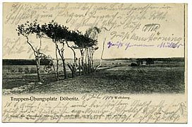
Military training area, the so-called "desert" Döberitz, 1904
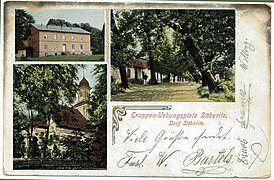
Döberitz village

Soldiers on the military training area, 1912

Military souvenir photo from May 1914


After the Second World War, it was temporarily converted as a refugee camp, but the Soviet Army took over the area in 1947. Up to 20,000 soldiers were housed there. In 1992, the military use of the site ended with the withdrawal of the troops. Since 1996, the use Bundeswehr ( garrisons Berlin-Spandau and Potsdam ) in the south of an approximately 600-hectare part of the site again as a training area for motor vehicles.
The barracks were gutted from 1994 and have been torn down gradually since then. The resulting fallow land will be developed as new development areas, which will again be based on the layout of the former warehouse structure. The leveled airport area has been managed as an outdoor game reserve by the Heinz Sielmann Foundation since 2004 , and the practice area has been a nature reserve crossed by hiking trails since 1997 .
Instructors, commanders and graduates
|
literature
- Paul Deickert: Döberitz. Reflections and pictures from the past and present of the Döberitz military training area. Döberitz / Berlin 1930.
- Paul Deickert: Historical Döberitz: Döberitz as it was and as it is. Berlin 1936.
- Erhard Cielewicz, Kai Biermann : Döberitz airfield. Birthplace of military aviation in Germany. Ch. Links, Berlin 2005, ISBN 3-86153-371-5 .
Web links
- From military training area to a natural paradise: “Sielmanns Naturlandschaft Döberitzer Heide” Heinz Sielmann Foundation
- Todays use
- History of the practice site
- On the history of the Döberitzer Heide; Supplements
- Pictorial history of Dallgow-Döberitz
Individual evidence
- ↑ a b History of the military training area , accessed on May 16, 2019.
- ^ Biographies of Carl Mohr and Paul Weidner as well as naming their buildings ; accessed on May 16, 2019.
Coordinates: 52 ° 30 '46 " N , 13 ° 3' 5.5" E