
Hahneberg (Berlin-Staaken)
| Hahneberg | ||
|---|---|---|
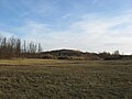
 View from Fort Hahneberg to the new Hahneberg |
||
| height | 87.6 m above sea level NHN | |
| location | Staaken , Berlin ( Germany ) | |
| Coordinates | 52 ° 31 '5 " N , 13 ° 9' 1" E | |
|
||
| particularities | - Fort Hahneberg - Bruno H. Bürgel Observatory |
|

As Hahneberg two are bumps in the southeastern part of Berlin-Staaken in Spandau district called: old Hahneberg ( ⊙ ) that before the establishment of the local forts Hahneberg 67 m high was and new Hahneberg ( ⊙ ), which was created artificially, 87, 6 m above sea level NHN is high and on which there is a green area.
The remains of Fort Hahneberg lie on the old elevation, which was removed from the surface especially for this purpose, and the small Bruno H. Bürgel observatory stands on the new one . The Hahneberg pond, which was later filled in, was located between the two elevations until after the Second World War .
Old Hahneberg
The old Hahneberg gained importance through the Fort Hahneberg, which was completed in 1888 . By an agreed exchange of territory of the Allies until then belonging to the district of Spandau Hahneberg 1946 arrived in the management of the Soviet zone of occupation , this task was then to from June 1, 1952 District Nauen , Potsdam district transferred. After the Wall was built in 1961, the mountain was located in the border area and was only accessible to the border troops of the GDR until the fall of the Wall in 1989 , but was mainly remembered by transit travelers , as it was located directly on Heerstraße and thus also at the former Staaken border crossing point / Heerstrasse is located. The fort is currently open to visitors again.
New Hahneberg
About 900 m southeast of the old Hahneberg there is an artificially created elevation, which is occasionally called Neuer Hahneberg .
The elevation is not a mountain of rubble like the Teufelsberg or the Insulaner , but arose in the 1960s and 1970s from a filled gravel pit onto which further rubble and excavation was then dumped. It is located directly on the former Seeburger Weg, which was the connection from Spandau to Seeburg . After the landfill was closed, the artificial hill, which rises about 45 meters above the surrounding terrain, has been transformed into a recreational area right on the border with the GDR since 1977 . This created a nature reserve with a pool in which the sand bells , the sand straw flower and the Russian chamomile can be found. For some time the wheatear has been breeding in cairns created especially for this purpose .
Tobogganing is often done on the new Hahneberg in winter and cross- golf is played in summer : the Bruno H. Bürgel observatory has been on the elevation since 1982 .
New Hahneberg
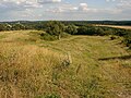
Neuer Hahneberg:
View south-east down the toboggan run ; with the Teufelsberg
(back left)


Individual evidence
- ↑ a b Digital topographic map 1: 10,000 (DTK10) , on stadt-berlin.de
Web links
- Slide show: Hahneberg and Fort Hahneberg , on berlin-motive.de