
Frankfurt-Ostend
|
8th district of Frankfurt am Main |
|
|---|---|
  |
|
| Coordinates | 50 ° 6 ′ 47 " N , 8 ° 42 ′ 2" E |
| surface | 5.564 km² |
| Residents | 29,477 (Dec. 31, 2019) |
| Population density | 5298 inhabitants / km² |
| Post Code | 60314, 60316, 60385 |
| prefix | 069 |
| Website | www.frankfurt.de |
| structure | |
| District | 4 - Bornheim / Ostend |
| Townships |
|
| Transport links | |
| Regional and S-Bahn | SE 50 RB 55 RB 64 S1 S2 S3 S4 S5 S6 S8 S9 |
| Tram and subway | U6 U7 11 12 14 |
| bus | 31 32 n5 n61 n62 n63 |
| Source: Statistics currently 03/2020. Residents with main residence in Frankfurt am Main. Retrieved April 8, 2020 . | |
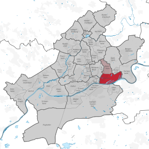
The Ostend is a district of Frankfurt am Main . It emerged from the so-called eastern outer city , which developed in the 19th century.
The population is 29,477.

location

The district is located in the Bornheim / Ostend district and begins in the west - at the Flößerbrücke and Obermainanlage - on the border with the city center . In the northwest - behind the Sandweg - is the district of Nordend-Ost . In the north, bounded by the Bornheimer Landwehr and the Ratsweg, is Bornheim and next to it - above the tracks of the Ostbahnhof - the Riederwald . Fechenheim follows in the east from Dieselstrasse . In the south, separated by the Main , there are - clockwise - the neighboring cities of Offenbach am Main , Oberrad and Sachsenhausen-Nord .
population

Compared to other city-center districts such as Westend or Nordend , large parts of the Ostend were considered to be working-class districts due to the proximity of the Osthafen and the Grossmarkthalle, so the prosperity of the Ostend population is still lower today. However, the district has recently become much more attractive due to the construction of numerous new residential complexes. The area around the Ostpark, on the other hand, has always been a popular residential area. a. the artists Alf Bayrle and Thomas Bayrle and the publisher and gallery owner Adam Silk .
Before the Second World War, the Ostend was shaped in the west by the Jewish population. At the Friedberger Anlage rose in 1907, inaugurated in 1938 and destroyed Orthodox Synagogue Friedberger Anlage . Today a high bunker stands in its place, in which several exhibitions illuminate the Jewish history of the Ostend. The Jewish orphanage and the hospital were located on Röderbergweg . Today many street names such as Reinganum- or Königswarterstraße still remind of the large Jewish community in Ostend. Furthermore, there are a number of stumbling blocks that are supposed to remind of the life of the Jews and other successors of National Socialism in Ostend.
Infrastructure


Ostend is the S-Bahn -Haltepunkt Ostendstraße the power of the Rhine-Main S-Bahn connected. With the exception of the S7 , all S-Bahn lines stop there. There are also several underground stations on the U6 and U7 lines, and the local connections are complemented by lines 11 ( Fechenheim - Höchst ) and 14 ( Bornheim - Sachsenhausen ) on the Frankfurt tram . With the Ostbahnhof , it also has a regional station for the trains to Hanau and Würzburg . The continuous main street of the district is the Hanauer Landstraße . It is a residential and commercial street in the west. From the railway bridge at the Ostbahnhof it widens and from the Ratswegkreisel it widens again to a busy arterial road towards the Main-Kinzig-Kreis .

Since February 2010, the disused wholesale market hall near Frankfurt's Osthafen has been expanded with a 185-meter-high new building and converted into the headquarters of the European Central Bank (ECB), which was moved into in autumn 2014 and opened in March 2015. The Frankfurt skyscraper master plan was specially modified for this purpose.
In parallel to the construction work of the ECB, the road network was and is being rebuilt or completely renewed. This also included upgrading the Honsell Bridge and building the Osthafen Bridge .
In the eastern areas, as a result of the construction of the east port (from 1908), workers' living quarters such as the Riederwald settlement , which today, however, form a separate district. With the Frankfurt Zoo , the Ostend is home to another institution known far beyond Frankfurt. The Naxoshalle cultural center is also nearby .
The quarter recovered only very slowly from the comparatively severe war damage and population losses caused by the deportation, but it was not only since the new construction of the ECB that it was considered a future-oriented district. After 1945 , areas that were often only used extensively and the site of the former gasworks on the Main have already been converted into residential areas, and one of the city's most innovative service and commercial districts has developed along the eastern harbor on the site of old industrial companies. The center of this economic quarter is the Hanauer Landstrasse with numerous automobile houses and design-oriented companies. In addition, “die Hanauer” (Landstrasse) is also a popular nightlife district with its diverse range of clubs, restaurants and bars.

The district is also becoming increasingly attractive in other areas. In 2002, the Frankfurt School of Finance & Management (emerged from the Bankakademie and the Hochschule für Bankwirtschaft ), one of the leading German private universities, settled in Ostend (Sonnemannstrasse) and in spring 2005 the Ostend Education Center opened right next to the Bankakademie , which has several schools and houses the Frankfurt adult education center. In addition, there is the traditional Dr. Hoch's Conservatory - Music Academy , which in 2005 also moved into its new building on Sonnemannstrasse. In October 2005, the Frankfurt Literaturhaus moved to the rebuilt classicist Old City Library from 1825. Between education center, Ostendstraße and Rückertstraße was Paul Arnsberg -Platz created. So far, however, it has not been able to take on the expected function of a public neighborhood meeting place, as the cool, stone surface must not be used as a children's playground.
literature
- Jewish Museum Frankfurt (ed.): Ostend - View into a Jewish quarter. Book accompanying the exhibition May 27–2. November 2000. Societätsverlag, Frankfurt 2001, ISBN 3-7973-0742-X
Web links
- Video interview with historian Helga Krohn about the Jewish history of the Ostend
- "Main Frankfurter Osten", district portal of the city of Frankfurt
Individual evidence
- ↑ To the bunker at Friedberger Anlage and the exhibition "Ostend. View into a Jewish Quarter"
- ↑ Project map of the city of Frankfurt on construction work in the Ostend
Old town | Bahnhofsviertel | Bergen-Enkheim | Berkersheim | Bockenheim | Bonames | Bornheim | Thorn bush | Eckenheim | Eschersheim | Fechenheim | Airport | Frankfurter Berg | Gallus | Ginnheim | Griesheim | Gutleutviertel | Harheim | Hausen | Heddernheim | Highest | Downtown | Kalbach-Riedberg | Nied | Nieder-Erlenbach | Nieder-Eschbach | Niederrad | Niederursel | Northrend-East | Northrend-West | Upper wheel | Ostend | Praunheim | Preungesheim | Riederwald | Rödelheim | Sachsenhausen-North | Sachsenhausen-South | Schwanheim | Seckbach | Sindlingen | Sossenheim | Unterliederbach | Westend-North | Westend-South | Zeilsheim
Inner city I (01) | Inner city II (02) | Inner city III (03) | Bornheim / Ostend (04) | South (05) | West (06) | Middle-West (07) | North-West (08) | Center-North (09) | North-East (10) | East (11) | Kalbach / Riedberg (12) | Nieder-Erlenbach (13) | Harheim (14) | Nieder-Eschbach (15) | Bergen-Enkheim (16)