
Hanauer Landstrasse
| Hanauer Landstrasse | |
|---|---|
|
|
|
 |
|
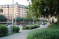
| At Osthafenplatz, view out of town, to the east | |
| Basic data | |
| place | Frankfurt am Main |
| District | Ostend , Frankfurt-Fechenheim |
| Created | middle Ages |
| Connecting roads | Allerheiligenstrasse (west), Bischofsheim (Maintal) , Frankfurter Landstrasse (east) |
| Cross streets | Friedberger- and Obermainanlage , Zobelstrasse , Grusonstrasse (to Ostbahnhof ), Osthafenplatz (to Osthafen ), Ratswegbrücke , Vilbeler Landstrasse , Alt-Fechenheim |
| Buildings | Riederhöfe , Neckermann mail order company , Mainkur inn, DE-CIX |
| Technical specifications | |
| Street length | 7 km |
The Hanauer Landstrasse is the most important eastern arterial road in Frankfurt am Main . It begins at the intersection of Allerheiligentor , Friedberger- and Obermainanlage, the district boundary between the city center and Ostend , and runs through the districts of Ostend and Fechenheim to the city limits to Bischofsheim (Maintal) . The road between Osthafen and Mainkur is a traditional location for Frankfurt's industrial and commercial enterprises.
history
The Hanauer Landstrasse is part of a historic trade route , the Untermainstrasse , which led from the mouth of the Main through the Kinzig valley and into the Fulda area. In 1765 the street was expanded to the Kurhessischen Chaussee . A customs post was built at the Mainkur near Fechenheim , which was destroyed in 1830 during the Hanau riots . This is where the Kurhessian controls took place on the border between Kurhessen and Frankfurt. In 1870 the industrialization of the street began with the opening of the Cassella works . Other companies were Voigt & Haeffner , Milchwerke Osthafen (Moha), Torpedo-Werke (bicycles) and the Frankfurter Brauhaus brewery . From 1961 to 2003, Hanauer Landstrasse, near the Ostbahnhof , was the largest fire station in Frankfurt until the fire, disaster control and rescue center was demolished and built in the Eckenheim district .
The area around Frankfurter Osthafen, the most important street of which is Hanauer Landstrasse, has been changing since the late 1980s. A large part of industrial operations was displaced by car dealerships and service companies. Many low-rise buildings from automobile sales companies were torn down again after a decade and replaced by multi-storey buildings. Marketing companies and advertising agencies have been added.
In addition to Mainzer Landstrasse , Hanauer Landstrasse has a high concentration of IT companies, parts of the world's largest Internet node DE-CIX are along the road, the others are also in Frankfurt.
Design -oriented companies have also settled on the street, in particular more exclusive furniture stores (e.g. ikarus Design , Ligne Roset , Roche Bobois ) but also the company 8linden Frankfurter Küche , which builds private kitchens out of stainless steel there.
The settlement of hotels is also worth mentioning, which is surprising in that the street can only be accessed directly by the tram.
Importance for traffic
The Hanauer Landstrasse forms the direct connection for traffic between the Frankfurt city center and the Fechenheimer Mainbogen on the Mainkur . Parts of the road are used for national traffic and belong to federal highways 8 and 40 .
The road runs parallel between the freight center of the railway and the Osthafen and is therefore of certain importance for the handling of goods.
Hanauer Landstraße is used for its entire length by tram line 11 and also by line 12 to Hugo-Junkers-Straße . Except for the section between Ostbahnhof and the intersection in front of the Ratsweg roundabout ( Riederhöfe station ), the tram has its own route . From the Ostbahnhof, the street has its own cycle path on both sides .
course
Between the Allerheiligentor and the intersection of Grusonstrasse / Sonnemannstrasse at the Ostbahnhof , the “Hanauer” is an inner-city residential and commercial street .
The continuation from the embankment (railway line to Deutschherrnbrücke ) to the junction of the A 661 houses offices and car dealerships. This area was traditionally shaped by Frankfurt industrial companies, some of which have disappeared through gentrification . They were replaced by luxurious offices and retail outlets, including car dealership chains. In total there are over 20 car dealerships on the street.
The last section from the A 661 to the east out of town was once shaped by large-scale industry, in its place there are hardware stores and large-scale warehouses. The headquarters of the Neckermann mail order company used to be located on this section .
Beginning at the All Saints' Gate

The former Neckermann mail order company

View from Cassellastraße towards Kaiserlei

View from Cassellastraße towards Mainkur

End of the street, looking west


Ostend
The Ostend was badly destroyed by aerial bombs during the air raids on Frankfurt am Main during World War II. The buildings on the lower Hanauer Landstrasse therefore mainly show the architecture of the reconstruction period. In this part of the street there are some shops to supply the district.
The Zobelstrasse , which branches off to the north , leads after a few steps to the Heinrich-von-Gagern-Gymnasium and the zoo , while the Windeckstrasse , which faces south, leads to the former wholesale market hall , the future European Central Bank . At the corner of Uhlandstraße an entrance to the underground is S-Bahnhof Ostendstraße the Rhine-Main S-Bahn .
East port
Unterhafen

The port area of the east port begins beyond the underpass under the Frankfurt – Hanau railway line . Honsellstrasse , which branches off to the south , leads to the southern part of the port, and Lindleystrasse , which begins at Osthafenplatz , to the north.
Hanauer Landstrasse is now accompanied in the south by the port area and in the north by the Frankfurt – Hanau railway with the Frankfurt Ost freight station . At the beginning of this section you can see the production and sale of beef sausage manufacturer Gref-Völsing on the right . There are several car dealerships on the street itself. This section of the street has changed a lot in the last ten years: Offices have moved into former industrial buildings, and the street section is increasingly taking on an inner-city character. Hotels, advertising agencies , furniture stores and the Frankfurt novel factory are now located here .
On the corner of Intzestrasse , a little south of Hanauer Landstrasse, are the few remaining remains of the Riederhöfe , a medieval estate belonging to the Frankfurter Landwehr and the historic Frankfurt railway . The border between the county of Hanau , later Kurhessen , and Frankfurt ran nearby . The central track workshop of the Frankfurt tram is on the north side .
Oberhafen
Shortly afterwards, the Ratsweg leading to the Kaiserleibrücke and the elevated city motorway A 661 cross the Hanauer Landstrasse. The junction is designed as a large roundabout , known as the Ratswegkreisel .
The streets Daimlerstrasse and Benzstrasse branching off to the south lead into the Oberhafen , the youngest part of the Frankfurt inland port.
This section of the street is wider than the previous one, and the industrial development stands off the street.
Fechenheim

On the south side of the street follows the large former building of the main administration of Neckermann Versand , a building by Egon Eiermann , which was occupied in 1960 and shortly afterwards the main plant of the chemical company Cassella Farbwerke Mainkur .
The tram line 12 coming from Frankfurt-Schwanheim ends at the junction with Hugo-Junkers-Straße . There is a turning loop here .
At Mainkur , tram line 11 turns right to the south into Alt-Fechenheim street and left it goes to Vilbeler Landstraße and Mainkur train station. Hanauer Landstrasse becomes Uferstrasse on the northern bank of the Main . The last house with the house number 587 is just before an overpass that enables the crossing of the directly adjacent tracks of the Frankfurt-Hanau Railway in the direction of Enkheim . After more than a kilometer, the road reaches the city limits of Maintal and changes its name to Frankfurter Landstrasse .
Web links
Individual evidence
- ↑ Stadtvermessungsamt Frankfurt am Main (ed.): Portal GeoInfo Frankfurt , city map