
Vilbeler Landstrasse
| Vilbeler Landstrasse | |
|---|---|
|
|
|
 |
|
| View towards downtown Frankfurt | |
| Basic data | |
| place | Frankfurt am Main |
| District | Fechenheim , Bergen-Enkheim |
| Created | 1819 |
| Connecting roads |
B521 (north) Hanauer Landstrasse ( Mainkur ) |
| Cross streets | Marktstraße, Wilhelmshöher Straße , Borsigallee with Enkheim underground station, access A 66 |
| Buildings | Berger waiting |
| Technical specifications | |
| Street length | 4.6 km in Frankfurt |
The Vilbeler highway is an important Tangentialstraße in the eastern part of Frankfurt am Main . It connects the districts of Fechenheim , Seckbach and Bergen-Enkheim and ends on the southern edge of Bad Vilbel .
course
History gallery from south to north:
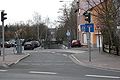
Beginning at the Mainkur in Fechenheim, with a view of the railway underpass and the bridge over the A66

In Enkheim

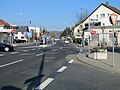
From the intersection of Borsigallee / Triebstraße / lamp

August 2012, after renovation, between Taschner- / Voltenseestrasse and lamp / Borsigallee (view from the north)

Connection to the federal road 521 to Bad Vilbel (straight ahead) and Büdingen (to the right), in Bergen


The Vilbeler Landstrasse begins at the Mainkur in the Fechenheim district. Here it is interrupted by the railroad tracks of the Frankfurt-Hanau Railway (underpass with footpath and bike path), then continues to the intersection of Birsteiner- / Kilianstädter Straße and through the Fechenheimer Wald (past Heinrich-Kraft-Park ). After crossing the A 66 motorway , you will reach the southern entrance to Enkheim. In Enkheim the street near the Hessen-Center leads past the terminus of the underground lines U4 and U7 (stop Enkheim) in a north-westerly direction.
Shortly after the crossing Voltenseestrasse / Taschnerstrasse the first uphill stretch begins. A few meters above Florianweg (cross street from the right), the street leads through Seckbacher area (formerly Rumpenheimer Straße). At the junction of Wilhelmshöher Straße in the Seckbach district , it leads with a wide right-hand bend past the route of the tram lines 32, 20 and 12, which have now been closed there to the exit of Bergen just before the Berger Warte . There, on the ridge of the Berger Ridge , the Vilbeler Landstrasse turns into a downhill section of about one kilometer as federal road 521 and flows into Frankfurter Strasse just after the city limits of Bad Vilbel.
history
The road from Fechenheim to Vilbel is very old. This connection has existed since Roman times - and probably even longer - although the exact route of the historic road is unknown. A distinctive crossing point is the one with the Hohen Strasse (exit towards Büdingen), a Stone Age connection Marköbel – Bergen – Höchst to the mouth of the Nidda .
Before the incorporation of Bergen-Enkheim in 1977, today's Vilbeler Landstrasse had different names. From the border between Fechenheim and Enkheim it was first called Fechenheimer Straße , then to the current junction of Florianweg Mainkurstraße . After that - on Seckbacher, i.e. Frankfurt area - it was named Rumpenheimer Straße up to the city limits at the end stop loop of tram line 32 (later 20 or 12) . This was followed by a stretch called Offenbacher Landstrasse (up to the Marktstrasse junction - the intersection was previously called Lindenplatz ). After the left turn it was named Vilbeler Straße or Vilbeler Landstraße up to the city limits to Bad Vilbel.
The road between Fechenheim and Enkheim was built in 1818, in 1820 the paving was extended to the Berger Höhe and in 1823 the rest of the road was extended to the state border.
In 1961, the student Heinz Ackermann made a remarkable find while excavating earth (at that time Offenbacher Landstrasse 9). He found a hand ax at a depth of about 1.5 m , the age of which has been dated to 120,000 years. The find is exhibited today in the Bergen-Enkheim local history museum .
modification
By July 2012, the area between the intersections “Borsigallee / Triebstraße / Leuchten” and “Voltensee- / Taschnerstraße” had been redesigned.
Web links
Individual evidence
- ↑ Stadtvermessungsamt Frankfurt am Main (ed.): Portal GeoInfo Frankfurt , city map
Coordinates: 50 ° 8 ′ 55 " N , 8 ° 44 ′ 37" E