
Frankfurt am Main tram
|
|
|
|---|---|
 |
|
| Basic information | |
| Country | Germany |
| city | Frankfurt am Main |
| opening | May 19, 1872 |
| electrification | from 1884 |
| operator | VGF |
| Transport network | RMV |
| Infrastructure | |
| Route length | 67.25 km (2016) |
| Gauge | 1435 mm ( standard gauge ) |
| Power system | 600 V DC overhead line |
| Operating mode | Bidirectional operation |
| Stops | 128 |
| business | |
| Lines | 8 main lines 2 reinforcement lines 3 special lines (Ebbelwei-Express, V, Nikolaus-Express) |
| Clock in the peak hours | 7½ min |
| vehicles |
R-railcar S-railcar K-Trieb- u. Sidecar (Ebbelwei-Express) |
| statistics | |
| Passengers | 61.6 million per year (2016) |
.png) |
|

The Frankfurt am Main tram has existed since 1872 and is, alongside the S-Bahn and U-Bahn, the third rail-bound public transport system in Frankfurt am Main .
The rail network of trams is the public transport company Frankfurt operated (VGF). It is part of the Rhein-Main-Verkehrsverbund (RMV) and today (2018) consists of ten regular tram lines and one special line. In 2016, the tram carried 61.6 million passengers on a route length of 67.25 kilometers, which corresponds to a share of around 20% of local public transport in Frankfurt.
In the history of the Frankfurt am Main tram , one of the first electric tram lines in the world, there were a large number of private and public operators and a number of conflicts over transport policy. After decades of working towards abolishing the tram in Frankfurt, there was a change in urban transport policy in the early 1990s . Since then, investments have been made in new vehicles and routes. In the overall traffic plan from 2005, a number of expansion measures were planned until 2015, but these were only partially implemented.
history
Overview


Tram traffic in Frankfurt began on May 19, 1872 with the opening of the first horse-drawn tram line , which was followed by other lines. 1884 followed electrically powered narrow gauge - line of FOTG , the first commercially operated electric streetcar in Germany with its railway-owned power plant , which is also the first time electrical power to businesses and households in Oberrad delivered. Despite its immature and fragile drive technology, this only meter-gauge line in Frankfurt tram traffic remained in operation for over twenty years. In 1888/89 two private companies opened steam trams . In 1891 two other companies experimented with the electric drive and relied on sub-lines or batteries , which in both cases did not lead to lasting success. It was not until 1899 that the first electric trams ran with the single-pole overhead contact line for direct current with a voltage of 600 volts , which is still used today - a technology that caught on.
In addition to various private companies, the city of Frankfurt also participated in tram traffic from 1898, and from 1906 the neighboring city of Offenbach , whose tram network was connected to the Frankfurt lines. The last private tram company became municipal property in 1955, and Frankfurter Stadtwerke has been the only operator in the region since 1968 .
The early years


The Frankfurter Trambahn-Gesellschaft (FTG), a Belgian private company, opened a horse-drawn tram in 1872 . This was Frankfurt's first tram line. It led from the Schönhof in the then neighboring town of Bockenheim via the Bockenheimer Warte to the main station . In quick succession, this first line was supplemented by more, in 1898 the FTG operated 16 lines over 30 kilometers of route. The track gauge of the tracks corresponded to the normal gauge of 1,435 millimeters that is usual for railways .
Another private company followed in 1884, the Frankfurt-Offenbacher Trambahn-Gesellschaft (FOTG), with a sensational innovation: an electric tram that can be used by the public. So far there have only been two electric tram lines in the world, the Siemens test route opened in 1881 in Lichterfelde near Berlin and an overland railway in Mödling near Vienna . It ran on the route between the terminus Deutschherrn-Kai next to the old bridge in Sachsenhausen through the municipality of Oberrad to Mathildenplatz in the neighboring town of Offenbach . The line was built in meter gauge and was incompatible with the FTG tracks. In operational terms, too, it initially remained a foreign body in the tram network, the electric drive was technically not yet fully developed and caused many breakdowns.
The Frankfurter Lokalbahn AG (FLAG) and the Frankfurter Waldbahn , which opened suburban lines in the north and south of the city in 1888 and 1889, were therefore designed as steam trams .
The International Electrotechnical Exhibition in 1891 was the occasion for further experiments with electric trams. The company Schuckert & Co. used overhead lines and underlines , while Siemens & Halske powered their trams with the help of accumulators . The FTG also experimented with battery-powered trams in 1897.
In 1898 the FTG was taken over by the city of Frankfurt. The first concession for the construction and operation of an electric tram for 99 years was awarded to the city of Frankfurt am Main on January 20, 1898 by the district president in Wiesbaden .
The electrification of the network began the following year . In the meantime, the single-pole overhead contact line (still in use today) had established itself as the most reliable system. All previous horse-drawn tram lines were electrified by 1904, the FLAG line acquired in 1901 followed in 1908. The draft horses were replaced by electric railcars . The routes taken over by the Frankfurt Forest Railway in 1898 were operated as steam trams until 1929.
The expansion of the network
After the electrification was completed, the focus was on further expanding the network. The fast growing city demanded the development of the new residential districts, numerous neighboring communities were incorporated into Frankfurt and secured the connection to the tram network. Except for the FLAG, the post tram opened in 1901 , the Homburg neighboring network opened in 1899 and the Offenbach tram, which had been in service since 1906, all lines were now in the hands of the Frankfurt municipal tram.
The growth phase lasted until the late 1930s . In 1938, the number of tram lines in Frankfurt peaked at 32, at which point the network had expanded to around 125 kilometers. The following Second World War soon led to numerous interruptions in tram traffic due to the air raids on Frankfurt am Main , which only came to a complete standstill at the end of the war.
Reconstruction after the war

Transport planning played an important role in the reconstruction of the war-torn city. Wide street lanes were drawn through the former old town. Generous facilities were also built for the tram, such as the large nodes at Hauptwache and at the main station .
From 1945 to 1950 two so-called “Roundup” lines operated exclusively for members of the American armed forces. They served both the traffic within the large “ restricted area ”, which was fenced in until mid-1948, as well as its connection with the smaller restricted area Heddernheim- “Roman town”. In order to bypass the “large restricted area”, diversions had to be laid. The Eschersheimer Landstrasse was connected to the Eckenheimer Landstrasse via the Marbachweg .
After the reconstruction was completed, a few route extensions followed to the outer parts of the city, for example to Höchst (1953) and Enkheim (1957) (only part of Frankfurt since 1977). In 1955 the city of Frankfurt took over the FLAG and its two suburban routes to Oberursel and Bad Homburg .
The shutdown
With the start of construction on the Frankfurt subway in 1963, tram routes began to be closed. The U- and S-Bahn should completely replace the trams in the medium term. The first underground line was opened in 1968, the second in 1974, the central S-Bahn tunnel in 1978. Every advance in the rapid transit network led to the closure of tram lines in order to avoid uneconomical parallel traffic .
With the opening of the third underground line in 1986, the " rail-free city center " was to be created: the tram should - for the most part without replacement - disappear completely from the city center, and the previous track areas should be used to "upgrade" the streets and squares . This led to increasing criticism of this concept, which culminated in public protests . Within a year, almost 60,000 people signed for the maintenance of the tram routes. Newspapers, radio and television devoted themselves to the conflict. Even personalities such as Bernhard Grzimek and the later DGB state chairman Dieter Hooge publicly criticized the concept.
As a result of the public protests, the Darmstadt regional council refused to close the old town on May 27, 1986 . The Lord Mayor of Frankfurt Wolfram Brück criticized this decision and threatened Frankfurt's exit from the Frankfurter Verkehrsverbund (FVV). Two days before the planned opening of the new subway line, Brück postponed the opening of the subway indefinitely and banned all opening ceremonies.
Only a few weeks later did the CDU signal its readiness to maintain the old town route with line 11. In return, District President Hartmut Wierscher decided not to keep three other lines. The preservation of the old part of the city finally ushered in a turning point in urban transport policy.
The rediscovery of the tram
With the decision of the city council to include the tram as an equivalent means of transport alongside the underground in the city's transport policy concept, the Frankfurt tram was given a future again in 1990. As a first step, the city government decided at the same time to build a 740 meter long connecting line between the old town and the Konstablerwache , the end point of tram line 12 at the time. Due to party political disputes and the resistance of the Frankfurter Verkehrsverbund , which saw parallel traffic with the underground, the Completion of this line, however, by 1999. As a further new line , a line from Bockenheim to the Rebstock development area was connected to the transport network in 2003 . In the current overall transport plan from 2004, the construction of several new tram routes and further optimization measures in the existing network are planned by 2015. The required investment is estimated at around 75 million euros. According to this, in 2015 the tram would have a share of around 6% of the expected 3.6 million daily journeys made by residents.
After the local elections in 2006, the city government declared its will not to build any more underground lines. Since the decision was made in 2011 to expand the underground line U5 as a barrier-free light rail system and not convert it into a tram, this declaration of intent has also become obsolete.
After the extension of the license from 1898 expired in 2011, a public tender for local transport services in the European Union in accordance with EU Regulation No. 1191/69, which would have been carried out by the local local transport company (LNG) traffiQ . Instead, the operation of the tram and subway network was assigned directly to the city's own VGF for a period of twenty years .
Lines
Overview
In 2019 there were 11 tram lines in Frankfurt. There are eight main lines ( diameter , tangential and feeder lines), two reinforcement lines and one special line:
| line | Type | Lines | Stops | Travel time | ||||
|---|---|---|---|---|---|---|---|---|
| Western (or north) terminus | Western (or north) line branch | Central route | East (or south.) line branch | East (or south) terminus | Branch 1 + center + branch 2 = sum | |||
| 11 | Diameter line |
Höchst Zuckschwerdtstrasse | Mainzer Landstrasse | Central station - old town route | Hanauer Landstrasse | Fechenheim Schießhüttenstrasse | 17 + 7 + 14 = 38 | 26 + 11 + 23 = 60 |
| 12 | Diameter line |
Schwanheim Rheinlandstrasse | Forest Railway - Niederrad | Friedensbrücke - Hauptbahnhof - Old Town - Konstablerwache | Nordend - Bornheim - Hanauer Landstr. | Fechenheim Hugo-Junkers-Str./Schleife | 15 + 8 + 14 = 37 | 23 + 14 + 26 = 62 |
| 14th | Diameter line |
Gallus Mönchhofstrasse | Mainzer Landstrasse | Central station - old town route | Wittelsbacherallee | Bornheim Ernst-May-Platz | 7 + 7 + 7 = 21 | 11 + 10 + 10 = 31 |
| 15th | Tangential line |
Niederrad Haardtwaldplatz | Niederrad | Sachsenhausen - Südbahnhof | Offenbacher Landstr. | Offenbach city limits | 8 + 8 + 9 = 25 | 12 + 11 + 13 = 36 |
| 16 | Diameter line |
Ginnheim | Ginnheim - Bockenheim | Central station - Friedensbrücke - Sachsenhausen - Südbahnhof | Offenbacher Landstr. | Offenbach city limits | 10 + 10 + 9 = 29 | 18 + 14 + 12 = 44 |
| 17th | Diameter line |
Rebstockbad | Vine range | Central station - Friedensbrücke | Stresemannallee - forest railway | Neu-Isenburg city limits | 5 + 10 + 3 = 18 | 8 + 17 + 5 = 30 |
| 18th | Diameter line |
Preungesheim Gravensteiner Platz | Friedberger Landstrasse | Konstablerwache - Ign.-Bubis Bridge - Sachsenhausen - Local train station | Mörfelder Landstr. | Sachsenhausen Louisa train station | 11 + 5 = 16 | 18 + 10 = 28 |
| 19th | Reinforcement line |
Schwanheim Rheinlandstrasse | Forest Railway - Niederrad | Sachsenhausen | Mörfelder Landstr. | Sachsenhausen Louisa train station | 15 + 4 + 7 = 26 | 23 + 5 + 9 = 37 |
| 20th | Reinforcement line |
Central Station | --- | Peace Bridge | Niederrad | Stadium tram | 3 + 8 = 11 | 4 + 13 = 17 |
| 21st | Feeder line |
Nied Church | Mainzer Landstrasse | Central station - Friedensbrücke | Niederrad | Stadium tram | 16 + 3 + 8 = 27 | 25 + 4 + 13 = 42 |
| EE | Special line |
zoo | short section Hanauer Landstr. | entire central net mesh counterclockwise with a detour to the fair | short section Hanauer Landstr. | zoo | 2 + 18 + 3 = 23 | 4 + 47 + 4 = 55 |
Since April 2007, low-floor vehicles have been used on all regular tram lines. Since 2013, however, there have been occasional use of (non-barrier-free) Pt wagons, which have been dismantled from Ptb wagons, when there is an acute shortage of vehicles . These wagons were used on fixed routes on lines 12 and 18 in 2013, on line 15 in 2020, and on lines 17 and 18 during rush hour . The journeys are marked accordingly on the posted timetables due to the lack of accessibility. This deployment is only to end with the delivery of the T-cars, which is to begin in December 2020.
For a long time, the U5 light rail line largely corresponded to a conventional tram and continues to run partly on the carriageway in the Eckenheimer Landstrasse area . But it was still officially referred to as the subway .
As a member of the RMV , the tram runs according to the regular timetable , which is designed by the local public transport company traffiQ . Since the 2015 annual timetable, lines 11 and 21 have 7½ (Monday-Friday) and 10-minute intervals (weekends), while line 16 has 10-minute intervals on weekdays and 15-minute intervals on Sundays and for all other lines a 10-minute cycle Monday-Friday and a 15-minute cycle on the weekends. In off- peak hours , the cars run every 15 or 30 minutes.
Diameter lines
Diameter lines connect two endpoints outside the center and traverse the center. Until 1986, many tram lines were cross-city lines. Line 16 is the only one of them that still operates today. The other diameter lines 11 and 12 were set up after the rethinking in transport policy in 1991 and 1999, respectively, and line 17 has been a further diameter line since 2015.
In 2015, every 15 minutes on line 12, except on Saturdays, every second journey ends at the ice rink .
Line 17 runs one of its two branches on one of the newer Frankfurt tram routes to the Rebstock site (opening in 2003) and - since the opening of the first section of the planned ring tram on December 14, 2014 on Stresemannallee - to Neu-Isenburg (city limits). Line 14, which previously ended there, has been shortened to the new terminus “ Louisa Bahnhof ”.
With the 2018/2019 timetable change on December 9, 2018, lines 14 and 18 also became cross-city routes again. Since this date, line 14 has been running from the Allerheiligentor via the old town, central station and Galluswarte along Kleyerstraße to the new terminus “Gustavsburgplatz”. At the same time, line 18 took over the southern section of the previous line 14 from the local station to Louisa. For the 2019/2020 timetable change on December 15, 2019, line 14 was extended to Mönchhofstraße station.
Feeder lines
Feeder lines only have a short section in the city center. They end in the city center or their two line branches converge at an acute angle. Almost all passengers on both branches get on or off at the same stop or change to other means of transport. In the case of the remaining feeder line 21 today, this station is the main train station.
Line 21 was created in 1986 in the shape that it still has today, with the exception of small modifications. It is thus a relic from the time of the " rail-free city center " project, when numerous feeder lines were created. Due to the two sections running almost parallel on both sides of the Main, there are hardly any passengers (except for events in the stadium ) who use connections beyond the main station from one line to the other.
This line ends in 2020 in Nied Church. In 2015 it ended at noon on Mönchhofstraße, until 2018 it also served the section of line 11 to Höchst Zuckschwerdtstraße on Sunday morning. At the other end of the line, the Oberforsthaus – Stadion section is only served by every second train every 7½ minutes. In contrast to the usual 7½-minute intervals on this line during the day, it also runs every 10 minutes during the summer and Christmas holidays at this time of the day.
Tangential lines
Between the two extremes of the diameter and feeder lines there are tangential lines that have a function of connecting city districts. They only touch the center and do not go through the main transfer stations. Today's Tangentiallinie 15 (also Line 14 until December 2018) was created in this form in 1992, when the concept of pure feeders was rethought and more attractive and independent tram routes were created again.
Line 15 runs Monday to Friday before 6:00 a.m., between 9:30 a.m. and 12:30 p.m. (holidays 3:30 p.m.) and from around 7:00 p.m. only to the Südbahnhof , the same applies on Saturdays, Sundays and public holidays all day.
Reinforcement lines
Reinforcement lines only make a few trips when there is a special need:
Line 19 is a pure school line with only two journeys in the morning from Schwanheim to Beuthener Straße, with the first going back to Schwanheim and the second going to Louisa S-Bahn station. There are also two trips back at noon. On the last day of school before the holidays, there is only one return train in the morning. In addition, there are two trips on line 19 from Schwanheim to Louisa Bahnhof at late noon, which deviate from the regular route after the “Vogelweidstraße” stop and lead directly over Stresemannallee to Louisa Bahnhof.
Line 20 is only operated at major events in the stadium . It then runs together with line 21 between the main station and the stadium tram in an i. d. R. 2-3 minute intervals. This line is the only one in Frankfurt that is "as a rule" operated with double trains made up of S-wagons.
Special lines


The special line "Ebbelwei-Express" is operated exclusively with high-floor K-cars .
As a city tour line, the Ebbelwei Express has been operating since 1977 with brightly painted vehicles from the first half of the 1950s . The tour begins at the zoo and leads through the old town , past the Römer, through the station district to the main station . From there, the route continues to the exhibition center and then back to the main train station and across the Main through the Sachsenhausen district of southern Main and back to the zoo. Drinks and mini pretzels are served on board . Originally intended as a short-term event, it has now developed into a nationally known tourist attraction that runs on weekends and public holidays according to a fixed timetable in the completely unusual 35-minute intervals and can otherwise also be rented. Special prices apply to the tickets, not those of the RMV tariff. The internal line number is "13".
Up to and including 2013, at Whitsun and during the “ Wäldchestag ” festival on the Tuesday after Whitsun, the “ Lieschen ” line ran on a route in the Frankfurt city forest that was otherwise not used by regular services . The internal line number was "15". In 2014, operations ceased because the line would have had to be repaired for 1½ million euros when the new line over Stresemannallee was built .
Stretches of today's network
Overview
The Frankfurt tram network is bundled in two central routes north and south of the Main. On the east and west side, the tram crosses the Main on the Ignatz-Bubis Bridge and the Friedensbrücke . The northern route is the so-called "old town route", the south side runs through the center of Sachsenhausen . On both sides of the Main, the routes fan out into several connecting routes.
Only the Ebbelwei Express runs on both routes and both bridges. It moves counterclockwise on the ring that is created in this way. All other current tram lines run in the middle of their route over a section of this central ring and drive on one of the connecting lines at both ends. The length of these sections can be very different: While line 11, for example, covers the entire old town, the central section of lines 17, 18 and 21 is only a few stops long.
The connecting routes to Offenbach, Louisa / Neu-Isenburg and Nied / Höchst are each served by two of the all-day main routes; the connecting route to Pforzheimer Strasse has not been used regularly since December 2014. This means that seven main lines are required for the twelve connecting lines. Line 18 to Preungesheim Ost was added as the thirteenth connection route in December 2011. In the general transport plan, the long-term inclusion of five of the twelve connecting lines in the Frankfurt light rail network is planned.
In the following, the two central routes are described first, followed by the connecting routes. These are arranged in a counter-clockwise order, starting with the north Main routes to the east:

| Ring: Old Town / Sachsenhausen | |||||||||||||||||||||||||||||||||||||||||||||||||||||||||||||||||||||||||||||||||||||||||||||||||||||||||||||||||||||||||||||||||||||||||||||||||||||||||||||||||||||||||||||||||||||||||
|---|---|---|---|---|---|---|---|---|---|---|---|---|---|---|---|---|---|---|---|---|---|---|---|---|---|---|---|---|---|---|---|---|---|---|---|---|---|---|---|---|---|---|---|---|---|---|---|---|---|---|---|---|---|---|---|---|---|---|---|---|---|---|---|---|---|---|---|---|---|---|---|---|---|---|---|---|---|---|---|---|---|---|---|---|---|---|---|---|---|---|---|---|---|---|---|---|---|---|---|---|---|---|---|---|---|---|---|---|---|---|---|---|---|---|---|---|---|---|---|---|---|---|---|---|---|---|---|---|---|---|---|---|---|---|---|---|---|---|---|---|---|---|---|---|---|---|---|---|---|---|---|---|---|---|---|---|---|---|---|---|---|---|---|---|---|---|---|---|---|---|---|---|---|---|---|---|---|---|---|---|---|---|---|---|---|
|
|||||||||||||||||||||||||||||||||||||||||||||||||||||||||||||||||||||||||||||||||||||||||||||||||||||||||||||||||||||||||||||||||||||||||||||||||||||||||||||||||||||||||||||||||||||||||
Old town route

The first part of the route was created with the construction of the Frankfurt Central Station and was opened with this on August 18, 1888 as a horse-drawn tram of the Frankfurt Tramway Company . The line led through the largely undeveloped Bahnhofsviertel and connected in the east to an already existing horse-drawn railway line, which previously had its terminus there at the former western train stations in Frankfurt . The Kaiserstraße , which was rebuilt after the demolition of the old western train stations, served the tram as a traffic route from 1889.
The restructuring of the old town has now started . The tram was extended there in 1899 to Paulsplatz at the Paulskirche in Frankfurt . The breakthrough in the old town from 1904-06 created the Braubachstraße for the extension to the Fahrgasse and until 1906 to the Allerheiligentor . Deviating from today's route, there was also a branch at today's Börneplatz through Rechneigrabenstrasse in the direction of Lange Strasse / Obermainbrücke . This section was shut down in 1986 as part of the “ rail-free city center ” project . A special feature to this day is the passage under the so-called "Bridge of Sighs", which connects the north and south of the New Town Hall . Also in 1906, the track in the western section of the railway station was relocated from Kaiserstraße to Kronprinzenstraße (today Münchener Straße ). The old route was put back into operation from 1932 to 1950 as a parallel route for the lines towards the north of the city center and then initially moved to Taunusstrasse and finally shut down in 1971.
Between 1968 and 1978, trams equipped with folding steps and accessible through tunnels ran on the route between Bahnhofsviertel and Hauptbahnhof. However, this temporary solution was eliminated with the construction of the B-tunnel of the subway . The former tunnel ramp in Große Gallusstraße now serves as an access to an underground car park .
After the Zeil became a pedestrian zone in 1978 and the tram service there was replaced by the S-Bahn , the old town route was now the most important east-west axis for tram cross-roads. Since it was busy with lines 10, 14, 15, 16 and 18, line 13 from Röderbergweg temporarily ended at Südbahnhof for two years . In 1980, line 10 was given a different route and line 13 was able to run again via the old town to the main station in its place . With the project "rail-free city center" in connection with the opening of the U6 and U7 light rail lines in 1986, the line was to be closed. After this intention had been prevented by a citizens' initiative and the intervention of the regional council , it remained in operation with line 11, and line 12 was added in 1999. While line 11 serves the entire route, line 12 also runs between the main train station and Börneplatz and then turns towards Konstablerwache . Since December 2018, line 14 has also been running from Ernst-May-Platz via the old town route to Gustavsburgplatz. Although the tram is no longer in question today, on the other hand, the condition before the days of the rail-free city center project with its numerous diameter lines was not restored. Nevertheless, around 10,000 passengers a day use the old town route (average value) even with the offer, which was significantly limited in comparison to the previous one.
Route situation at Börneplatz
The “Börneplatz” stop is in the section used by the two lines 11 and 12 that run there, before the junction of line 12 in the direction of Konstablerwache. Line 18 comes from Konstablerwache in the direction of Allerheiligentor and cannot serve the current stop. Therefore the new stop “Börneplatz / Stoltzestrasse” became necessary, where the lines 11 and 18 also stop.
Furthermore, according to the new inner city concept, it is planned to relocate the section through Battonnstraße to Allerheiligenstraße along the old town route and to set up a stop there a short distance from Konstablerwache. The “Börneplatz / Stoltzestrasse” stop would then be omitted.
Sachsenhausen and Main crossings

The current central route of the tram in Sachsenhausen between Friedensbrücke and Ignatz-Bubis-Brücke consists of several sections on which different lines operate. Historically, too, it is not a uniform route:
First, two horse-drawn tram routes to the local train station were opened in 1881 and 1883 . The first of the two ran over the Obermainbrücke (today Ignatz-Bubis-Brücke), coming from Lange Straße, and is still in operation today. The other led over the Untermainbrücke and the Schaumainkai. Spatially separated from these two lines, a horse-drawn tram line was built in 1897 from the main station via today's Friedensbrücke to the no longer existing hippodrome in Stresemannallee. The two sections of the Sachsenhausen tram network were only connected in 1908 by a route between Schweizer- / Gartenstraße and Hippodrom.
The tram traffic between the two parts of the city of Frankfurt bounded by the Main ran over the three bridges mentioned until 1984. The Obermainbrücke had to be closed to vehicles of all kinds in 1938 due to a lack of material for necessary repairs. After the Second World War , all three bridges were then closed. Initially, a separate sub-network was created south of the Main, before two Main bridges could be used again in 1949 and finally the Friedensbrücke in 1951.
In 1955 the section from the Untermainbrücke to the Südfriedhof via the Schaumainkai, the Schulstrasse and the local train station was closed. In 1965 the route from the Südbahnhof to Schweizer Strasse was moved from Diesterweg to Hedderichstrasse. Finally, on the occasion of the opening of the crossing under the Main by the underground lines U1 to U3 in 1984, the line from what was then Theaterplatz (today: Willy-Brandt-Platz ) over the Untermainbrücke to Gartenstraße was closed. The remaining route over the other two bridges still exists today. The way it is used by passengers varies greatly: While only around 3,000 passengers cross the Ignatz-Bubis Bridge every day, the Friedensbrücke is one of the most popular tram routes in Frankfurt with around 20,000 passengers a day. Although most of these travelers turn towards the University Hospital shortly after crossing the Main , around 10,000 passengers are counted daily on the route in Gartenstrasse between Stresemannallee and Schweizer Strasse.
For the future, the construction of a connection from Börneplatz to the local train station via the old bridge is under discussion.
| Hanauer Landstrasse | |||||||||||||||||||||||||||||||||||||||||||||||||||||||||||||||||||||||||||||||||||||||||||||||||||||||||||||||||||||||||
|---|---|---|---|---|---|---|---|---|---|---|---|---|---|---|---|---|---|---|---|---|---|---|---|---|---|---|---|---|---|---|---|---|---|---|---|---|---|---|---|---|---|---|---|---|---|---|---|---|---|---|---|---|---|---|---|---|---|---|---|---|---|---|---|---|---|---|---|---|---|---|---|---|---|---|---|---|---|---|---|---|---|---|---|---|---|---|---|---|---|---|---|---|---|---|---|---|---|---|---|---|---|---|---|---|---|---|---|---|---|---|---|---|---|---|---|---|---|---|---|---|---|
|
|||||||||||||||||||||||||||||||||||||||||||||||||||||||||||||||||||||||||||||||||||||||||||||||||||||||||||||||||||||||||
Hanauer Landstrasse and Fechenheim (11, 12)

The seven-kilometer tram route on Hanauer Landstrasse is the main connection from Fechenheim to downtown Frankfurt. It is almost completely used by line 11 and by line 12 between the Ratswegkreisel and the Hugo-Junkers-Straße loop . The total travel time is 22 minutes.
As early as 1875 there was a horse-drawn tram line to the Hanau train station on Hanauer Landstrasse and the corner of Zobelstrasse , which, however, led further north over the Zeil and past the zoo .
The first section of today's route was built in 1906 as a continuation of the old town route through the densely built-up Wilhelminian-style district of Ostend along Hanauer Landstrasse. In 1910, the line was extended by a large section and since then has continued on Hanauer Landstrasse through the industrial eastern Ostend north of Frankfurt's eastern port to the Riederhöfen .
Here a line branches off to Bornheim via Ratsweg , and the VGF's central track workshop is also located on Ratsweg. In October 1928, shortly after the incorporation of Fechenheim, this new district also got a tram connection. The route was extended over the eastern section of the Hanauer Landstrasse. At the Mainkur train station , she leaves Landstrasse and takes a tight curve into the center of Fechenheim. Then from there it runs mostly beside a footpath near the banks of the Main arc along and reaches the final stop "Schießhüttenstraße" on Fechenheimer cemetery . There used to be a triangular track with a track looping unique in Frankfurt , which was replaced in 2001 by a single-track turning system for bidirectional cars.
Route situation at the Ostbahnhof
In 1992 the bus stop with loop and siding at the Ostbahnhof was closed. According to the ideas at the time, this shutdown should only be temporary until the extensive redesign of Danziger Platz was completed. After that, the tram should return in a different form. In order not to have to interrupt the tram service of line 11, new tracks were built in Hanauer Landstrasse and the old track connections were disconnected from the network, so the “Ostbahnhof” stop was a bit removed from the actual train station.
In June 2002 - three months after the purchase of the area around the wholesale market by the European Central Bank - decided the city council to permanently leave the tram regardless of the redesign on its current track. On the one hand, the relocated “Ostbahnhof” stop is closer to the future headquarters of the European Central Bank at the wholesale market hall, and on the other hand, there were concerns that the tram could obstruct the rest of the traffic on Hanauer Landstrasse. Instead, after the end of the expansion work at the Ostbahnhof subway station, a new tram stop was built at Honsellstraße in order to shorten the transfer routes between line 11, the U6, the planned Nordmainische S-Bahn and the regional trains . While the new stop was named "Ostbahnhof / Honsellstraße", the relocated stop was renamed "Ostbahnhof / Sonnemannstraße".

| Wittelsbacherallee | |||||||||||||||||||||||||||||||||||||||||||||||||||||||||||||||||||||||||||||||||
|---|---|---|---|---|---|---|---|---|---|---|---|---|---|---|---|---|---|---|---|---|---|---|---|---|---|---|---|---|---|---|---|---|---|---|---|---|---|---|---|---|---|---|---|---|---|---|---|---|---|---|---|---|---|---|---|---|---|---|---|---|---|---|---|---|---|---|---|---|---|---|---|---|---|---|---|---|---|---|---|---|---|
|
|||||||||||||||||||||||||||||||||||||||||||||||||||||||||||||||||||||||||||||||||
Wittelsbacherallee (14)
On the same day in 1908, tram lines were opened in Wittelsbacherallee and in the Rhönstrasse, which runs parallel to it. The stretch of Wittelsbacherallee initially ended at the Bornheimer Landwehr. In 1913, the tracks in Rhönstrasse were extended to Röderbergweg. The extension of the Bornheimer Landwehr to Inheidener street in until 1930 in May - settlement on Bornheimer Hang followed in 1931. A year earlier wrong there for the first time the line 15. They drove from the Inheidener road around fifty years for the stadium .
In 1985, the parallel line in Rhönstrasse was shut down due to the construction of the subway in the direction of Enkheim and line 13, which ran there, was completely shut down. Line 15, which previously only ran to the main train station via the old town, was extended to the former terminus at Stadion der 13. Shortly afterwards, the route 15 was straightened and the routes previously traveled by it from Börneplatz via Rechneigrabenstraße to Lange Straße and from Allerheiligentor via Friedberger Anlage to the zoo were discontinued. The former of the two sections remained for several years operating range .
The wave of decommissioning culminated in 1986 with a big step towards the rail-free inner city that was striven for at the time . As part of this concept, "the tram and bus lines [...] should, in addition to their development and connection tasks in the outer city areas [...] take on the important feeder function to the rapid transit systems." A particularly good example of the conversion of a former cross-city line to The route through Wittelsbacherallee, which was no longer connected to the stadium as line 15 via the old town section, but led almost in a ring as line 18 over Hanauer Landstrasse to Enkheim, offers a pure feeder . Both branches of the route were supposed to transport passengers to the zoo, where the terminus of the U6 and U7 light rail lines was then.
In the summer of 1992 there was a change in the route in connection with the opening of the branch of the U7 light rail line to Enkheim , which replaced most of the previous line 18. Line 14 then ran from Neu-Isenburg to the terminus “Inheidener Straße”, which was renamed “Ernst-May-Platz” in 1997. The pure feeder function of the tram has been toned down to a function that connects districts. Nevertheless, the operation was initially only "on a trial basis" because of the "parallel" tram lines U4 and U7. In fact, the route in Wittelsbacherallee with around 1500 daily passengers is still one of the least used tram lines in Frankfurt.
Since the timetable change on December 9, 2018, line 14 has been running from Ernst-May-Platz via the zoo, old town route, main station and Galluswarte on Kleyerstrasse to the Gustavsburgplatz stop . With the timetable change on December 15, 2019, the line was tied through to Mönchhofstraße station.
| Nordend / Bornheim | |||||||||||||||||||||||||||||||||||||||||||||||||||||||||||||||||||||||||||||||||||||||||||||||||||||||||||||||||||||||||||||||||
|---|---|---|---|---|---|---|---|---|---|---|---|---|---|---|---|---|---|---|---|---|---|---|---|---|---|---|---|---|---|---|---|---|---|---|---|---|---|---|---|---|---|---|---|---|---|---|---|---|---|---|---|---|---|---|---|---|---|---|---|---|---|---|---|---|---|---|---|---|---|---|---|---|---|---|---|---|---|---|---|---|---|---|---|---|---|---|---|---|---|---|---|---|---|---|---|---|---|---|---|---|---|---|---|---|---|---|---|---|---|---|---|---|---|---|---|---|---|---|---|---|---|---|---|---|---|---|---|---|---|
|
|||||||||||||||||||||||||||||||||||||||||||||||||||||||||||||||||||||||||||||||||||||||||||||||||||||||||||||||||||||||||||||||||
Zoo loop
A curiosity is the single-track turning loop at the zoo that went into operation in 1986 . Initially, it was not used to turn the tram around at a terminus, but was part of the route of lines 11 and 14, which were then running on Hanauer Landstrasse . The cars branched off their route on Zobelstrasse , drove to the zoo, stopped there and turned , stopped again and drove back to Hanauer Landstrasse and continued on their route there. The purpose of this five-minute additional route was to fulfill its feeder function to the Zoo tram station , which was served by tram line 11 V. For the carriages on line 11, the detour trips ceased in 1990 with the opening of the Ostendstraße S-Bahn station on the direct route . Line 14 has passed the zoo since 1992 without turning there. However, the loop is used by the carriages on the “ Ebbelwei-Express ” line as the start and end point of the route for turning.
Nordend and Bornheim (12)
In 1902 the line from Glauburgstrasse to Rohrbachstrasse was put into operation. Just two years later it was extended to Günthersburgpark and in 1913 to the test item . Line 12 was already running on the route from the main train station to the test item at that time. However, it still drove via Oeder Weg . The other end point was moved to Mönchhofstraße in 1923, to Nied in 1940 and to Höchst in 1952 . Due to the construction of the subway in Eschersheimer Landstrasse , the section from Eschenheimer Tor to Glauburgstrasse across Oeder Weg was closed in 1964 . Line 12 then drove over the Scheffeleck . In 1971 this route was canceled and replaced by a new route from the Hessendenkmal to Scheffelstrasse and over the new Friedberger Landstrasse . With the closure of the Zeil route in 1978, the route from Goetheplatz to Schäfergasse via Schillerstrasse and Stiftstrasse was put back into operation for a few years. It was finally shut down in 1986 as part of the “ rail-free inner city ” project and the western end of line 12 to Konstablerwache was withdrawn.

At that time, feeder lines from Bergen (line 20) and Enkheim (line 23) to the Bornheim Mitte underground station ran on the section of today's line 12 to the “Ostpark / Eissporthalle” stop . In 1986 the route of line 12 was combined with that of the previous line 20 and this was discontinued. When the line to Bergen was closed in 1992, line 12 then took over the route from line 23 to Enkheim. A few months later in the same year, after the opening of the U7 underground line to Enkheim, the tram network in the east of Frankfurt was reorganized. Line 12 now led to Hugo-Junkers-Straße, and during rush hour even to Fechenheim Schießhüttenstraße.
After the “rediscovery of the tram”, a short link between Konstablerwache and the old town was put into operation in 1999, which made it possible to extend line 12 to Schwanheim. Since December 11, 2011, line 18 has also been running on part of the line 12 from Börneplatz to the “Rohrbachstraße / Friedberger Landstraße” stop, where it branches off in the direction of Preungesheim Ost. Over 10,000 passengers are expected daily on the section on which both lines travel together.
| Preungesheim East | |||||||||||||||||||||||||||||||||||||||||||||||||||||||||
|---|---|---|---|---|---|---|---|---|---|---|---|---|---|---|---|---|---|---|---|---|---|---|---|---|---|---|---|---|---|---|---|---|---|---|---|---|---|---|---|---|---|---|---|---|---|---|---|---|---|---|---|---|---|---|---|---|---|
|
|||||||||||||||||||||||||||||||||||||||||||||||||||||||||
Friedberger Landstrasse to Preungesheim Ost (18)
In 1999, the city council decided to set up a tram connection from Konstablerwache to the new residential area Preungesheim Ost. In the general traffic plan 2004 it is included as line 18 , its southern end point is at the local train station . The main component is a 3.5 kilometer long, double-track new line that connects to the existing line 12 at the Friedberger Landstrasse / Glauburgstrasse junction (stop “Rohrbachstrasse / Friedberger Landstrasse”) and leads over Friedberger Landstrasse to the eastern edge of Preungesheim. Near the end of the route, it opens up the new development areas Frankfurter Bogen , Preungesheim and Bornheim . It includes eight new stops at intervals of 325 to 620 meters and low-floor platforms. The route on Friedberger Landstraße is designed as an asphalt public transport lane and is shared by bus line 30, which runs parallel to the “Bodenweg” stop . Priority circuits for the tram are installed along the route . The journey time is 29 minutes. Line 18 runs every ten minutes until around 8 p.m.
The start of operations was originally planned for 2006. Delays in the planning, in the tendering process and a legal dispute that went as far as the Frankfurt Higher Regional Court , in which an unsuccessful applicant had lodged an objection to the award of the construction work, meant that construction work could only begin in April 2009. In a press release, Verkehrsgesellschaft Frankfurt initially assumed that the new line would open regardless of the timetable change in September 2011, and it finally went into operation on December 11, 2011.
With the new line 18, points connections are used for the first time, which have existed for a long time but have not yet been used in regular traffic: Coming from the Konstablerwache to the left towards Börneplatz / Stoltzestrasse and at the Allerheiligentor right towards Hospital zum Heiligen Geist . Until then, these points were only used in the event of diversions or disruptions.
| Bockenheim / Ginnheim | |||||||||||||||||||||||||||||||||||||||||||||||||||||||||||||||||||||||||||||||||||||||||||||||||||||||||||||||||||||||||||||||||||||||||||||||||||||||||||||||||
|---|---|---|---|---|---|---|---|---|---|---|---|---|---|---|---|---|---|---|---|---|---|---|---|---|---|---|---|---|---|---|---|---|---|---|---|---|---|---|---|---|---|---|---|---|---|---|---|---|---|---|---|---|---|---|---|---|---|---|---|---|---|---|---|---|---|---|---|---|---|---|---|---|---|---|---|---|---|---|---|---|---|---|---|---|---|---|---|---|---|---|---|---|---|---|---|---|---|---|---|---|---|---|---|---|---|---|---|---|---|---|---|---|---|---|---|---|---|---|---|---|---|---|---|---|---|---|---|---|---|---|---|---|---|---|---|---|---|---|---|---|---|---|---|---|---|---|---|---|---|---|---|---|---|---|---|---|---|---|---|---|---|
|
|||||||||||||||||||||||||||||||||||||||||||||||||||||||||||||||||||||||||||||||||||||||||||||||||||||||||||||||||||||||||||||||||||||||||||||||||||||||||||||||||
Bockenheim and Ginnheim (16)
The current route from the main train station to Ginnheim was created in this form in 1986 with the opening of the C light rail line . Until then, there was a network of tram lines in this area. The only remaining route consists of three sections, each of which was part of its own route:
- The section from the main train station to the “Adalbert- / Schloßstraße” station used to continue to Praunheim Bridge. Line 18 last ran there. The northernmost part of this line was shut down in 1985, the adjoining section from Industriehof to Hausen was integrated into the light rail network in 1986 and the middle section was converted into an operating line in the same year . The latter should possibly be used again as part of the planned ring tram in the future.
- The section between Westbahnhof and Bockenheimer Warte is the last part of the originally busy route of lines 2 and 6 from Hauptwache to Westbahnhof. In the course of the underground construction, the line numbers and routes changed several times in the 1970s and 1980s; lines 22 and 21 last operated there. This line was closed in 1986, except for a few meters that have been preserved today, and replaced by the new C light rail tunnel.
- In addition, line 3 in the direction of Rödelheim ran between Hauptwache and Bockenheimer Warte . This then led through Leipziger Strasse and the church square to Schönhof . So it was the direct forerunner of today's underground.
- On the section from Ginnheim to Bockenheimer Warte, line 19 used to continue on Mendelssohnstraße to the main station. Although the tram route C did not replace the connection from the exhibition center via Mendelssohnstraße to Bockenheimer Warte, this section was shut down in 1986 and replaced by a bus line.


Today's route to Ginnheim includes part of the very first Frankfurt tram route, opened in 1872, from Schönhof to Hauptwache, then Schillerplatz. The horse-drawn tram cars first drove there over Schloßstraße, Bockenheimer Warte and Opernplatz . A branch to the Westbahnhof, the then Bockenheimer Bahnhof, was created in 1896. In 1906, the connection between the main train station and the Westbahnhof via the exhibition grounds was put into operation directly as an electrical route. The line from Bockenheimer Warte to Ginnheim was opened in two sections in 1911 and 1914. The terminus there was called "Waldgasse".
The line starting from Ginnheim has been leading via the main train station to Haardtwaldplatz since the 1950s. This line carried the number 1 until 1968, then the 8 and from 1986 finally the number 19, as the lower line numbers were gradually assigned to the subway. In 1989 the southern branch of line 19 was swapped with that of line 15 in order to now offer a direct connection between the parking lots at the stadium and the exhibition center with line 19. In the following year, line 19 to the fair was withdrawn and instead line 16 was extended from the fair to Ginnheim; this meant that 19 facility railcars could run on the line. The two -way vehicles that became available were needed for the route to Enkheim, where the turning loop was omitted in 1991 due to the construction of the urban railway.
According to the local transport plan of 1997, with the extension of the U4 tram from the main train station via the trade fair to Bockenheimer Warte, tram 16 should only run between Offenbach city limits and Frankfurt main train station. Later it should have been extended to the vineyard area. For the remaining route from Ginnheim to the Westbahnhof, an island operation was planned, which - far away from the other tram routes - was to serve as a feeder to the subway at the Bockenheimer Warte. However, calculations of the expected number of passengers ultimately led to a different decision: When the U4 extension opened in 2001, only line 19 was omitted; the 16 remained in its previous form. And since the Rebstock route opened in 2003, line 17 has also been running on the shared section between the main station and Varrentrappstrasse.
In Ginnheim there was another line that was not connected to the first track. It led from the previous school through Raimundstrasse to Dornbusch, where it led to Eschersheimer Landstrasse . This was used by line 17, which then drove via Reuterweg - Platz der Republik - Hauptbahnhof to Gutleutstraße. At the terminus "Ginnheim (school)", the two tracks were brought together with a switch. After the railcar had moved, the sidecar was allowed to run off into the butt track lying on the slope and then picked up by the railcar there.
| Vine range | |||||||||||||||||||||||||||||||||||||||||
|---|---|---|---|---|---|---|---|---|---|---|---|---|---|---|---|---|---|---|---|---|---|---|---|---|---|---|---|---|---|---|---|---|---|---|---|---|---|---|---|---|---|
|
|||||||||||||||||||||||||||||||||||||||||
Vine route (17)


In November 2003, test drives could take place on the Rebstock tram for the first time. The route was inaugurated on December 13, 2003. Originally, the newly emerging urban quarter on the Rebstock was supposed to be accessible by underground. However, mainly because of the high costs, this plan was abandoned. In addition, the “ City West ” industrial park could also be developed with the tram . A subway would have avoided this.
The construction work was originally supposed to be completed in 2002, but was delayed due to contaminated sites in the soil of the Friedrich-Ebert-Anlage . The line branches off the Ginnheim tram route at the intersection of Hamburger Allee / Schloßstraße / Varrentrappstraße and runs on a single track through the green median of Hamburger Allee to the northwest. This construction method was chosen because a citizens' initiative had enforced the preservation of a large part of the avenue trees. The clearing of the affected trees was partly carried out under police protection. At the “Nauheimer Straße” stop near Westbahnhof , the line then turns west under the elevated railway and runs through Voltastraße, the main street of City West. Here, for the first time in Frankfurt, the external lanes of individual traffic were raised in order to enable barrier-free passenger exchange.
Behind the Katharinenkreisel, which is crossed by the tram, the second construction phase begins in the Rebstockviertel on the western edge of the Kuhwaldsiedlung . The Leonardo-da-Vinci-Allee was built together with the grass track of the tram. The double-track terminus was created at Rebstockbad with two simple track changes. A turning loop was not built because only bidirectional vehicles are used on the route.
| Mainzer Landstrasse | |||||||||||||||||||||||||||||||||||||||||||||||||||||||||||||||||||||||||||||||||||||||||||||||||||||||||||||||||||||||||||||||||||||||||||||||||||||||||||||||||||||||||||||
|---|---|---|---|---|---|---|---|---|---|---|---|---|---|---|---|---|---|---|---|---|---|---|---|---|---|---|---|---|---|---|---|---|---|---|---|---|---|---|---|---|---|---|---|---|---|---|---|---|---|---|---|---|---|---|---|---|---|---|---|---|---|---|---|---|---|---|---|---|---|---|---|---|---|---|---|---|---|---|---|---|---|---|---|---|---|---|---|---|---|---|---|---|---|---|---|---|---|---|---|---|---|---|---|---|---|---|---|---|---|---|---|---|---|---|---|---|---|---|---|---|---|---|---|---|---|---|---|---|---|---|---|---|---|---|---|---|---|---|---|---|---|---|---|---|---|---|---|---|---|---|---|---|---|---|---|---|---|---|---|---|---|---|---|---|---|---|---|---|---|---|---|---|---|
|
|||||||||||||||||||||||||||||||||||||||||||||||||||||||||||||||||||||||||||||||||||||||||||||||||||||||||||||||||||||||||||||||||||||||||||||||||||||||||||||||||||||||||||||
Mainzer Landstrasse (11, 14, 21)
The tram line in Mainzer Landstrasse was put into operation on August 20, 1895. The route initially only led to the Galluswarte and was used by accumulator trams from Pollak. In the direction of the city center, it was connected to the then still new main station via the Platz der Republik junction through Bahnstrasse (today Düsseldorfer Strasse) . The continuation towards Taunusanlage / Reuterweg was opened up in the same year by the horse-drawn tram. A first extension to the west took place in 1902 to the Rebstöcker Straße stop in the Gallusviertel . From 1905 tram cars of line 11 drove on this route for the first time.

In 1909 it was lengthened a second time and a branch was added: At the Galluswarte, the branch line runs southwest through the industrial area along Höchster Straße (today's Kleyerstraße), past the Adlerwerke , to Rebstöcker Straße. This connects the branch line to the main line on Mainzer Landstrasse. A short continuation through Kleyerstraße to Griesheimer parade ground, where the Friedrich-Ebert-Siedlung planned by Ernst May was built in 1930 , existed from 1912 to 1944.
Also in 1912 the main line to the north was extended towards Griesheim . The new terminus at Flugplatz was on what was then Flughafenstrasse, which led to Rebstock Airport . Today the street and station are called Mönchhofstraße. The turning loop there was closed in April 2006. In their place, a turning track was built between the tracks.
In 1917 the local military administration requested a tram connection from Frankfurt am Main via the city of Höchst am Main to Sindlingen as a feeder to the war-important plant in Höchst. At that time, however, there were insurmountable difficulties in the way of realizing this project. During the war, a line of around 14 kilometers had to be built, which also had to cross the Frankfurt-Höchst railway line between Griesheim and Nied . Since building an overpass or underpass structure was out of the question, the plan to extend the tram route was postponed indefinitely. Instead, after 1924 a bus line was set up from Mönchhofstraße via Griesheim and Nied to Höchst.
In 1928 the town of Höchst and a large part of the district of Höchst , to which Griesheim and Nied also belonged, were incorporated. The incorporation agreement provided for the extension of the tram to Höchst. First, however, a branch line to Griesheim station was built in 1930 . It branched off from Mainzer Landstrasse to Waldschulstrasse to the south and was used by line 14 to Fechenheim until it was closed in 1978.

On December 14, 1935, the extension of the main line was opened. For this purpose, Mainzer Landstrasse had to be widened and an overpass built for the Frankfurt-Höchst railway line. Due to the lack of a bridge over the Nidda , the route temporarily ended at St. Mark's Church in Nied. A turning loop and a provisional final stop were built at this lower church. An expansion could no longer take place because of the arms production.
It was only after the Second World War, 24 years after the incorporation, that the necessary bridge structure was built in the course of the re-routing of the Mainzer Landstrasse as a bypass road around Alt-Nied. Now the city was able to extend the route to Höchst. Ludwig-Scriba-Strasse was created in Höchst through the redesign of a field path, on which a separate track for the tram was set up. The route was officially opened on January 21, 1952. Since then, however, the route has "initially" only led to the Bolongaropalast in the east of the district. The bypassing of an entire city block is used as a turning loop. A breakthrough to the Höchst station was considered "impossible" at the time.
A “final” extension to the Höchst station is currently being pursued. The city favors a guided tour along the railroad tracks of the station in two possible variants.
At the eastern end of Mainzer Landstrasse, however, the section to the Taunusanlage was given up in 1986 as part of the “rail-free city center” because of the new underground line.
Since the closure of the section east of Platz der Republik, the line has its current length. Lines 11 and 21 cover just under eight kilometers in 24 minutes. In the meantime, the line from the Mönchhofstraße stop has been re-routed in preparation for use as a light rail line and largely separated from road traffic. In 1989, the striking bridge over the newly built junction of Bundesstraße 40a between Jägerallee and Birminghamstraße went into operation. The plans for including this section of the route in the underground network are on hold for the time being. On the other hand, it is more realistic to extend the route through the Höchst city center and Königsteiner Strasse to Frankfurt-Höchst train station .
| Niederrad and Schwanheim | |||||||||||||||||||||||||||||||||||||||||||||||||||||||||||||||||||||||||||||||||||||||||||||||||||||||||||||||||||||||||||||||||||||||||||||||||||||||||||||||||||||||||||||||||||||||||||||
|---|---|---|---|---|---|---|---|---|---|---|---|---|---|---|---|---|---|---|---|---|---|---|---|---|---|---|---|---|---|---|---|---|---|---|---|---|---|---|---|---|---|---|---|---|---|---|---|---|---|---|---|---|---|---|---|---|---|---|---|---|---|---|---|---|---|---|---|---|---|---|---|---|---|---|---|---|---|---|---|---|---|---|---|---|---|---|---|---|---|---|---|---|---|---|---|---|---|---|---|---|---|---|---|---|---|---|---|---|---|---|---|---|---|---|---|---|---|---|---|---|---|---|---|---|---|---|---|---|---|---|---|---|---|---|---|---|---|---|---|---|---|---|---|---|---|---|---|---|---|---|---|---|---|---|---|---|---|---|---|---|---|---|---|---|---|---|---|---|---|---|---|---|---|---|---|---|---|---|---|---|---|---|---|---|---|---|---|---|---|
|
|||||||||||||||||||||||||||||||||||||||||||||||||||||||||||||||||||||||||||||||||||||||||||||||||||||||||||||||||||||||||||||||||||||||||||||||||||||||||||||||||||||||||||||||||||||||||||||
Niederrad and Schwanheim (12, 15, 19, 20, 21)
| Stresemannallee | |||||||||||||||||||||||||||||||||||||||||||||||||
|---|---|---|---|---|---|---|---|---|---|---|---|---|---|---|---|---|---|---|---|---|---|---|---|---|---|---|---|---|---|---|---|---|---|---|---|---|---|---|---|---|---|---|---|---|---|---|---|---|---|
|
|||||||||||||||||||||||||||||||||||||||||||||||||
Stresemannallee (17)
A new connection route in the Sachsenhausen district provides a fast connection between Neu-Isenburg and the main train station . The route on the central promenade of Stresemannallee has been kept free for traffic for decades. The temporary users of the affected areas, especially an adventure playground in the home settlement , resisted a relocation for a long time, which led to delays in the planning progress. After the playground had been partially relocated, construction work on the tram line began in early 2014. On December 13, 2014, the line went into operation.
The 1.2 kilometer long new line branches off behind the Stresemannallee / Gartenstrasse stop, crosses Kennedyallee and follows Stresemannallee to the south to merge into the existing route of line 14 towards Neu-Isenburg at the Mörfelder Landstrasse intersection. A transfer stop at the Stresemannallee S-Bahn station was built as a new building on the route section. The route is used by line 17, which previously ended at the main station (Pforzheimer Strasse). Line 17 now runs over the Friedensbrücke and the new line to the final stop Neu-Isenburg city limits. Line 14 was shortened with the commissioning of the new line to the Louisa S-Bahn station .
The project was decided in 2006 by the transport committee of the city council. However, an extension from the outskirts of Neu-Isenburg to the city center there was initially rejected. In mid-August 2012, the Frankfurt magistrate decided on the construction and financing proposal, and on October 11, 2013, the decision of the city council followed. The total cost of the project was 19 million euros.
| Sachsenhausen and Neu-Isenburg | |||||||||||||||||||||||||||||||||||||||||||||||||||||||||||||||||
|---|---|---|---|---|---|---|---|---|---|---|---|---|---|---|---|---|---|---|---|---|---|---|---|---|---|---|---|---|---|---|---|---|---|---|---|---|---|---|---|---|---|---|---|---|---|---|---|---|---|---|---|---|---|---|---|---|---|---|---|---|---|---|---|---|---|
|
|||||||||||||||||||||||||||||||||||||||||||||||||||||||||||||||||
Sachsenhausen and Neu-Isenburg (17, 18)

| Offenbacher Landstrasse | |||||||||||||||||||||||||||||||||||||||||||||||||||||||||||||||||
|---|---|---|---|---|---|---|---|---|---|---|---|---|---|---|---|---|---|---|---|---|---|---|---|---|---|---|---|---|---|---|---|---|---|---|---|---|---|---|---|---|---|---|---|---|---|---|---|---|---|---|---|---|---|---|---|---|---|---|---|---|---|---|---|---|---|
|
|||||||||||||||||||||||||||||||||||||||||||||||||||||||||||||||||
Offenbacher Landstrasse (15, 16)


As early as 1848 and until 1955, the Frankfurt-Offenbacher Lokalbahn operated between Frankfurt am Main and the neighboring city of Offenbach am Main , a railway that had its terminus at Sachsenhausen station , today's local station in Frankfurt am Main. However, this was a state railway .
The tram route on Offenbacher Landstrasse has its origins in the Frankfurt-Offenbacher Trambahn-Gesellschaft (FOTG), which opened in 1884, between the terminus Deutschherrn-Quai at the Alte Brücke and Mathildenplatz in Offenbach. In 1906 the line was switched from narrow gauge to standard gauge in phases . The first tracked route led from the old cemetery in Offenbach to the market square. A depot with a workshop was built at the old cemetery. The route section was served by vehicles from Frankfurt. In December, the track section to the state border Hessen-Nassau / Prussia or city border Frankfurt am Main / Offenbach am Main was changed.
After the level crossing of the Frankfurt tram with the Prussian state railway at the state border had been removed by raising the railway line on December 18, 1910 , the line was operated jointly by the Frankfurt and Offenbach trams . The name of the line was chosen according to the Frankfurt system.
Since the gauge change in 1906, the route of the former FOTG route in the Frankfurt city area has been used by line 16 without interruption.
The state border between Prussia and Hesse, which was called "Adolf Hitler Ring" between 1933 and 1945, became a pure city border when the State of Hesse was re-established after the Second World War . At times, other Frankfurt lines were also operated as far as Offenbach, such as Frankfurt Line 4, which ran from May 9, 1960 to 1967 from Goetheplatz in Frankfurt to Offenbach's Old Cemetery. Subsequently, a joint operation of this line was operated until the line was closed on June 1, 1969.
In the neighboring city of Offenbach, instead of the tram as a means of transport, an omnibus system has been used since the 1950s. By 1967, all tram lines of the Offenbach municipal tram (SSO) were shut down and the remaining rolling stock of three four-axle open- plan cars was sold to Bremerhaven . Line 16 was initially not affected by this measure and continued to lead to the old cemetery in Offenbach, where it ended in a block bypass .
On June 1, 1969, the city of Offenbach closed the section of the line between the old cemetery and the market square, where a stump end point was created. In later years the terminus was rebuilt once and the route was shortened by a few meters. In order to be able to continue using the remaining Offenbach route, new cars had to be purchased, as Frankfurt did not have any bidirectional large-capacity trains at that time . The costs for the new acquisition of the eight new type "O" trams were borne proportionally by the two cities and the state of Hesse.
Like their successors, the "P" cars , these vehicles had validators for the Offenbach city area, as Offenbach was not a member of the FVV and for this reason two different tickets had been required since 1907. From December 31, 1991, a joint ticket was available. The type “R” low-floor wagons used from 1993 had no validators, so that until the RMV was founded in 1995 it was necessary to continue to use conductors on the Offenbach section . Another disadvantage in terms of tariff was the higher fare compared to a trip within Frankfurt.
From the late 1980s to the early 1990s, on behalf of the Offenbach retailers' association, an “L” trolley was set up for luggage storage at the final stop on the market square on Advent Saturdays .
Since 1989, the retail trade association and the Offenbach am Main Chamber of Industry and Commerce have been campaigning for the tram to be taken back from the market square to Kaiserstraße.
When the S-Bahn from Frankfurt to Offenbach was opened in 1995 , this should mean the closure of the Offenbach section, but this was due to citizen protests from Frankfurt-Oberrad and traffic initiatives (including Pro Bahn and the citizens' association "DALLES"), which also included special trips tried to make the population aware of the tradition of the connection could be prevented. In the period that followed, the tram through Offenbach was increasingly viewed as "undesirable". In order to monitor the maximum speed of 7 km / h in the pedestrian zone on Offenbach's market square, Offenbach set up a speed measurement system specifically for the tram.
The attitude of the majority of Offenbach merchants, who demanded a closure, was further strengthened through intensive lobbying , which among other things tried to point out what they saw as uneconomical parallel traffic between the S-Bahn and the tram on line 16.
On June 1, 1996, the Darmstadt regional council finally approved a closure request from the city of Offenbach with the condition that all tracks and operating systems were to be kept operational, and the line was closed one day later. Immediately afterwards - despite the decommissioning requirements - the decommissioning of the track system began by blanketing the grooves. The last ride on the rails in Offenbach took place on September 5, 1996 by the initiatives Pro Bahn and DALLES with a lever trolley . The aim was to draw attention to the violations of the decommissioning requirements.
In 2001 the provisional terminus with a triangular track was converted into a double-track stump end with a central platform . In 2005 the overhead line masts in Frankfurter Strasse were removed. The rails in Frankfurter Strasse were completely dismantled by 2006.
Since the mid-2000s there has been an increasing desire to return the tram to Offenbach. In particular, Offenbach retailers, who have suffered a sharp drop in sales as a result of the closure, and Frankfurt politicians, primarily the head of the transport department Lutz Sikorski (Greens), advocated an extension of line 16 into Offenbach city center. Initial discussions on this began in November 2006.
Former routes

Frankfurt local train
The Frankfurter Lokalbahn route in Eschersheimer Landstrasse was opened in 1888 and extended to Bad Homburg and Oberursel until 1910 . The branches north of Heddernheim always represented an operational peculiarity in the tram network, as they had a wider rail profile due to the freight traffic there. In order to avoid derailment, a tram with widened wheel tires could be used there, which by a "v" (for " V was marked orortstrecken") in the series designation.
In 1968, most of the route was integrated into the subway network and has since been used by the U1 to Ginnheim , U2 to Bad Homburg-Gonzenheim and U3 to Oberursel Hohemark lines .
The expansion of the Stadtbahn network in 1971 to Bad Homburg meant that the Homburg route had to be "temporarily" withdrawn to the Gonzenheim district , as the previous tram in Bad Homburg used narrow city streets that were not passable for subway cars.
Until 1978, the tunnel of the Eschersheimer Landstrasse still operated through the tunnel of the Mt series trams , since then it has been used exclusively for the underground operation of the lines U1 to U3 .
Rödelheim
In 1889 a horse-drawn tram line was set up from Bockenheimer Schönhof via Rödelheimer Landstrasse to the Niddabrücke in Rödelheim . In 1904 this line was the last to be electrified in Frankfurt. In 1911 it was extended over the Nidda to Rödelheimer Bahnhof. Until 1915 it was separated from the rest of the tram network by the Main-Weser Railway , since for safety reasons only unmanned trams were allowed to cross the railway lines at ground level. It was only possible to connect it to the route to Opernplatz with the construction of the Breitenbach Bridge at the Industriehof . In 1978 it was shut down on the occasion of the opening of the S-Bahn and replaced by bus line 34.
Berkersheim, Eckenheim, Preungesheim
The route to Berkersheim went down in the city's history due to the violent disputes about its closure.
The first section of the route was opened in 1911 and branched off north of the main cemetery from the route that had existed since 1907 via the Eckenheimer Landstrasse . From there it led over the then undeveloped area to Marbachweg and shortly afterwards turned into today's Gießener Straße. The route changed there to the Homburger Landstrasse and drove it in a northerly direction up to the level of Weilbrunnstrasse in Preungesheim . In 1919 a single-track extension followed over undeveloped land to Oberwiesenweg in the northeast of Preungesheim, and Berkersheim only got a tram connection in 1925. A continuation to Bad Vilbel was no longer realized due to the shortage of materials in the years before the Second World War.
Incorporation into the Eckenheim light rail line , which opened in 1974, had been considered, but due to the operational risks and the limited capacity of the mostly single-track route, the idea was finally dropped. The line between Gießener Straße and Berkersheim was closed on February 25, 1978. In Preungesheim, the tram was replaced by the B1 light rail line (today's U5), and the 39 bus line was set up as a replacement in Berkersheim. The official reason for the closure was the construction of the federal highway 661 , for which an expensive underpass would have had to be built. In fact, however, the shutdown took place under pressure from the Frankfurter Verkehrsverbund , who saw the line called Wilde 13 popularly (based on the line number in use since 1951) as an inadmissible "parallel service" to the S-Bahn that opened in the same year. The shutdown led to notable protests from the affected population for the first time, and years later the citizens' initiative “Save the 13” demanded that operations be resumed. Only the complete dismantling of the remaining tracks in the early 1980s ended the discussion about the future of the line.
The tram returned to the area on December 11, 2011 in the form of the new line 18 to the newly created Preungesheim housing estate Frankfurter Bogen ; a continuation to Berkersheim is not planned.
| Bergen until 1992 | |||||||||||||||||||||||||||||||||||||||||||||||||||||||||||||||||||||||||||||||||||||
|---|---|---|---|---|---|---|---|---|---|---|---|---|---|---|---|---|---|---|---|---|---|---|---|---|---|---|---|---|---|---|---|---|---|---|---|---|---|---|---|---|---|---|---|---|---|---|---|---|---|---|---|---|---|---|---|---|---|---|---|---|---|---|---|---|---|---|---|---|---|---|---|---|---|---|---|---|---|---|---|---|---|---|---|---|---|
|
|||||||||||||||||||||||||||||||||||||||||||||||||||||||||||||||||||||||||||||||||||||
Mountains


The extension to Bergen , northeast of Frankfurt, which was still independent at the time, was put into operation on October 15, 1913. Before that, the lines ended at Lahmeyerstraße in Riederwald . Before it was closed, the line was served by line 20 from Bornheim until the 1980s . After line 12 had lost its diameter function in 1986 due to the opening of the C-line of the subway and the associated closure of the line through Stephan- and Stiftstrasse, instead of ending in Bornheim at the “test item”, it went to Bergen and replaced line 20. In February 1992, the line service was stopped and the old track was shut down, as the extension of the C line to Enkheim required a new alignment of the tracks on Borsigallee. The “Gwinnerstraße” tram station was built at the level of the former junction. Most of the route remained, however, as parts of it were to be used for the planned extension of the U4 line from Bornheim to Bergen.
From the junction with Gelastraße, the tracks are on the higher-lying lane for private traffic to the north. From the former Leonhardsgasse stop, today's bus stop, the route runs through the Seckbacher Ried . A short time later, the former route crosses the Bitzweg and runs between it and the edge of the development of Bergen to the intersection with Wilhelmshöher Strasse, which, coming from Seckbach , crosses the route. From here the tracks have been dismantled or tarred; the section is now open to pedestrians . Only the turning loop on the southwestern edge of Bergen has been preserved and is now used as a stop for bus route 43.
In the meantime, however, there are plans to reactivate the route that has been preserved, but whether as a tram or light rail route is unclear. A reactivation as a light rail line with a subsequent tunnel into the old town of Berger would be possible. Since the superstructure has deteriorated considerably during the decommissioning years, a complete renewal of the route is necessary.
future plans
After the closure of tram line 16 in Bockenheim after the local elections in 2006 was dropped by the black-green coalition agreement, there are no longer any specific closure plans for Frankfurt tram routes. However, a very long period of time continues to elapse from the planning idea to implementation for new lines, and the vast majority of projects fail in the course of this process due to concerns of various kinds.

By far the largest expansion project is the ring tram proposed in the general transport plan and approved in principle by the city parliament . It is to use the new line from Neu-Isenburg to the main train station via Stresemannallee. From here it will be taken using the existing routes via the exhibition center , Hamburger Allee to Schloßstraße. Shortly before the Breitenbach bridge, there is a new line that leads on the northern edge of Bockenheim via Ginnheimer Straße, Franz-Rücker-Allee and Wilhelm-Epstein-Straße to the Dornbusch district . At Dornbusch, the ring line reaches the former route 13 along the Marbachweg to Eckenheim . Another new line has to be built from Gießener Strasse to Friedberger Landstrasse , which joins line 18. It is led to Fechenheim via the Nordend and Bornheim . The ring line was originally supposed to be completed by 2015, but only the first section was completed by that date. So far (as of January 2015) the remaining sections have not gone beyond declarations of intent. The line is to be opened by 2030.
Since the underground line from the Bockenheimer Warte to Ginnheim will not be built in the foreseeable future and an alternative route is being examined with the Ginnheimer curve , where tram line 16 could be preserved, it is likely that the ring tram will between the stops Adalbert- / Schlossstraße and Markuskrankenhaus will use the existing route of line 16. Independent of the ring tram, the section between the Ginnheim and Varrentrappstrasse stops is to be modernized and accelerated.
At the end of 2015, the Frankfurt city parliament decided to close the gap between Ginnheim and to build the ring tram. Both projects were accepted with a large majority. However, construction is not expected to start for both projects for a few years.
Other Projects
Also under discussion are
- an extension of line 11 from Zuckschwerdtstraße in Höchst to Höchst station in connection with the regional bypass West
- a new line from the main train station through Gutleutstrasse to the Gutleut letter center as a replacement for bus line 37,
- relocation of the forest railway line on line 12 in the area of the Goldstein settlement from the southern outskirts to Straßburger Strasse,
- an extension of line 12 to the Höchst industrial park ,
- a relocation of the old town route from Battonnstrasse to Allerheiligenstrasse, which runs parallel to the north of it,
- a modernization of tram line 16 in Bockenheim and Ginnheim ,
- a tram connection from Konstablerwache over the old bridge to Sachsenhausen ,
- an extension of line 17 from the stop " Neu-Isenburg city limits" to the train station Dreieich-Sprendlingen ,
- a new line to the south or north station in Bad Vilbel ,
- an extension of line 15 from Haardtwaldplatz to the Niederrad office district
- an extension of line 16 through Offenbach to Fechenheim .
- a four-track expansion of the " Hauptbahnhof " tram stop
In 2005 the magistrate was asked to check whether a tram route to the University Campus Westend via Mainzer Landstrasse , Taunusanlage , Reuterweg and Bremer Platz as well as Eckenheimer Landstrasse could be set up, but said no in October 2006 on the grounds that the bus route 36 open up the area “as needed” and you can not do without two lanes in Reuterweg and Mainzer Landstraße because of individual traffic.
However, there are plans to use freight trams on the tram routes . Test operation began in September 2018 with a logistics tram that transports parcels via the rail network from a central collection point to special “micro-depots”, from where they are then finely distributed by parcel services. This should happen during off-peak times; In the future, in addition to tram routes, underground routes could also be used. This project is thus in the tradition of the former post tram in Frankfurt am Main .
New line concept
On July 6, 2020, the traffic director Klaus Oesterling presented a new tram concept. With the concept, two previous operating routes will be reactivated. The concept is to be implemented gradually by 2025, as z. B. a turning system for the tram has to be built at the Industriehof . The line network will look like this:
| line | Destination 1 | Destination 2 | change |
|---|---|---|---|
| 11 | Fechenheim Schießhüttenstrasse | Höchst Zuckschwerdtstrasse | No |
| 12 | Fechenheim Hugo-Junkers-Strasse | Schwanheim Rheinlandstrasse | No |
| 13 | Industrial yard | Gutleut Heilbronnerstrasse | New line, reactivation of two operating lines |
| 14th | Bornheim Ernst-May-Platz | Nied Church | Extension from Mönchhofstraße to Nied church |
| 15th | Fechenheim Schießhüttenstrasse | Niederrad Haardtwaldplatz | Extension from the Südbahnhof to Schießhüttenstraße, omission of journeys to Offenbach city limits in the HVZ |
| 16 | Offenbach city limits | Höchst Zuckschwerdtstrasse | The line branch to Ginnheim is taken over by the 21. |
| 17th | Neu-Isenburg city limits | Rebstockbad | No |
| 18th | Louisa train station | Preungesheim Gravensteiner Square | No |
| 19th | Offenbach city limits | Friedberger waiting | Discontinuation as a school booster line, takes over the trips of the 15 to the Offenbach city limits in the peak hours |
| 20th | Niederrad office town | Rebstockbad | Elimination of the stadium line for football matches, reinforces the 12 and 17 |
| 21st | Stadium tram | Ginnheim | The line branch to Nied Kirche is taken over by the 16 |
vehicles

The railcar series are designated in Frankfurt in chronological order with letters. Since the electrification, the Frankfurt tram has almost exclusively used two-axle motor coaches and sidecars from various manufacturers, which were replaced from 1955 by large-capacity coaches from the Düwag company . Since 1993, low-floor vehicles have been procured ( R and S series ), which have completely replaced the high-floor vehicles of the Pt series since April 1, 2007 . Since the N series was phased out in 2004, only bidirectional vehicles have been used in regular service. Seven Pt cars will be used again in the route network from December 2018 to 2021. After that, the first Citadis X05 cars from Alstom will be used.
Individual open- plan cars have been preserved as operational museum vehicles and are occasionally used on special trips . The vehicles of the Ebbelwei-Express and the Lieschen , which operates until 2013, are converted two-axle vehicles of the K series . Almost all of the earlier series have been preserved; they are housed in the Transport Museum in Frankfurt-Schwanheim .
Depots, depots, depots

The Frankfurt tram currently has two depots, two car halls and the central tram workshop.
Former tram companies in the suburbs
In addition to the companies mentioned
there were the following tram companies in the immediate vicinity of Frankfurt :
With the exception of Hanau , the route networks of all the companies mentioned were connected to one another, so theoretically one could have created a continuous line from Saalburg to Neu-Isenburg or from Höchst to the south of Offenbach , which, however, was never practiced. In some cases, individual lines were operated jointly with the companies in the suburbs, so the lines to Oberursel and Bad Homburg were operated by the FLAG and the Frankfurt tram, and Offenbach tram trains also ran on Frankfurt line 16 to Offenbach .
See also

- Local transport in Frankfurt am Main
- Lieschen (tram)
- Children's tram in Frankfurt am Main
- Transport Museum Frankfurt am Main
literature
- Arbeitsgemeinschaft Blickpunkt Straßenbahn eV Berlin (Ed.): Tram atlas 2005 Germany: Tram, U-Bahn, S-Bahn, O-Bus . Berlin: Arbeitsgemeinschaft, Berlin 2005, ISBN 3-926524-24-3 .
- Thomas Hanna-Daoud (Red.): Local traffic in Frankfurt. Tram, underground, S-Bahn, omnibus, railroad . In: Local tram transport special. No. 7 . GeraMond Verlag , Munich 2000, ISBN 3-89724-010-6 .
- Dieter Höltge, Günter H. Köhler: Trams and light rail vehicles in Germany . 2nd Edition. 1: Hessen. EK-Verlag , Freiburg 1992, ISBN 3-88255-335-9 (contains a complete list of vehicles).
- Günter H. Köhler, Claus Seelemann: Post and Tram : Post transport with trams in Germany and abroad . GH Köhler, Hofheim, Reichenberger Weg 6, Hofheim 1998, ISBN 3-934873-99-5 .
- Jens Krakies, Frank Nagel: Stadtbahn Frankfurt am Main: A Documentation . 2nd Edition. Frankfurt am Main 1989, ISBN 3-923907-03-6 .
- Horst Michelke, Claude Jeanmaire: One hundred years of Frankfurt trams: 1872 - 1899 - 1972 = Tramways of Frankfurt am Main (Western Germany) . 1st edition. Villigen AG: Verlag Eisenbahn, book publisher for railway and tramway literature, Brugg / Switzerland 1972, ISBN 3-85649-018-3 .
- Frank Nagel, Monika Mutzbauer, Matthias Arning: Mobility for Frankfurt - 50 years of modern Frankfurt local transport . Ed .: Verkehrsgesellschaft Frankfurt am Main mbH (VGF) corporate communications . Societäts Verlag , Frankfurt am Main 2018, ISBN 978-3-95542-320-9 .
- Robert Schwandl, Mark Davies: Frankfurt Stadtbahn Album - The Frankfurt Light Rail Network + S-Bahn . 1st edition. Robert-Schwandl-Verlag, Berlin 2008, ISBN 978-3-936573-21-3 (German, English).
- Walter Söhnlein, Jürgen Leindecker: The Frankfurter Lokalbahn and its electric Taunus-Bahnen . GeraMond Verlag , Munich 2000, ISBN 3-932785-04-5 .
- Walter Söhnlein, Gerta Walsh: Clear the way! - Railways in the Taunus 1860–1910–2010 . Societäts Verlag , Frankfurt am Main 2010, ISBN 978-3-7973-1223-5 .
- General traffic plan Frankfurt am Main, result report 2004 - study on behalf of the city planning office on the future development of Frankfurt traffic networks. (PDF; 23.8 MB) City of Frankfurt am Main, December 1, 2004, accessed on November 18, 2018 .
- Dana Vietta, Bernd Conrads, Frank Nagel, Ole Bannert, Uwe Niemann, Charles Tang: U . Frankfurt U-Bahn - the backbone of the Main metropolis. Ed .: Verkehrsgesellschaft Frankfurt am Main (VGF) Corporate Communication, Historic Trams of the City of Frankfurt am Main eV Verkehrsgesellschaft Frankfurt am Main, Frankfurt am Main 2018.
- Anton Wiedenbauer, Hans-Jürgen Hoyer: Driving into the future: the history of the Frankfurt tram . Waldemar Kramer publishing house , Frankfurt am Main 1968.
Web links
- Frankfurt Transport Company
- traffiQ , local public transport company Frankfurt am Main: plans and maps , information material , timetables
- Trampage Frankfurt This website has been providing information on the history and current developments of the Frankfurt tram since 1996
Individual evidence
- Dieter Höltge, Günter H. Köhler: Trams and light rail vehicles in Germany . 2nd Edition. 1: Hessen. EK-Verlag , Freiburg 1992, ISBN 3-88255-335-9 .
- ↑ a b c d e f p. 321
- ↑ a b c d p. 322
- ↑ a b c p. 334
- ↑ a b c p. 336
- ↑ p. 92
- ↑ a b c d e f p. 98
- ↑ p. 94
- ↑ p. 150
- ↑ a b p. 45
- ↑ a b c d p. 69
- ↑ p. 64
- ↑ p. 73
- ↑ pp. 77/78
- ↑ p. 77
- ↑ p. 60
- ↑ a b p. 65
- ↑ a b c p. 331
- ↑ p. 70
- ↑ pp. 64-65
- ↑ p. 62
- ↑ p. 74
- ↑ p. 81
- ↑ a b p. 91
- ↑ a b c d e f g h p. 261
- ↑ a b c p. 355
- Anton Wiedenbauer, Hans-Jürgen Hoyer: Ride into the future - The history of the Frankfurt tram , Frankfurt 1968
- FVV traffic route plans for the city of Frankfurt am Main
- ^ Map of Transportation Lines covering the territory of Greater Frankfurt a. M. Valid as of Jan. 1, 1979 (English)
- ↑ a b c Valid from September 29, 1985
- ↑ a b c Valid from September 28, 1986
- ↑ a b Valid from May 31, 1992
- Further evidence
- ↑ a b Figures 2016 , Verkehrsgesellschaft Frankfurt (VGF), accessed on March 29, 2018
- ↑ TraffiQ operating data for 2016, see short profile (PDF)
- ↑ Lecture of the magistrate of February 18, 2005, M32, see also: General traffic plan Frankfurt am Main 2004 - results report (PDF; 25 MiB)
- ↑ 60 years of electric tram in Frankfurt am Main , tram of the city of Frankfurt a. M. (Ed.), Page 9 f.
- ↑ a b http://www.trampage.de/fallbeispiel%3A_linie_12_p280.html , accessed on February 18, 2011
- ↑ Claus-Jürgen Göpfert: Roth strikes against sheer anger. In: Frankfurter Rundschau , April 25, 2007
- ↑ a b c traffiQ, line overview , status: February 23, 2010, accessed on March 14, 2011 (PDF; 5.4 MiB)
- ↑ Timetables, stop notice, notice timetable 1 , Rhein-Main-Verkehrsverbund, accessed on March 18, 2011
- ^ From U-mach 'tram: Pt-Tw back on the tram network , Frankfurter Nahverkehrsforum
- ↑ Dennis Pfeiffer-Goldmann: Frankfurt makes trams longer: One line benefits in particular. In: Frankfurter Neue Presse. February 6, 2020, accessed May 8, 2020 .
- ↑ Appendix 1 to M 102/2014, page 4
- ↑ Investigation report feasibility study U5 , p. 9, accessed on March 25, 2011 (PDF; 1.4 MiB)
- ↑ traffiQ Local Local Transport Company Frankfurt am Main mbH: Frankfurt Local Transport: More offers for more passengers. December 16, 2019, accessed December 18, 2019 .
- ^ Official website of the Ebbelwei Express accessed on March 18, 2011
- ^ Verkehrsgesellschaft Frankfurt am Main (ed.): Service instruction No. 15/2009
- ↑ Lieschen says quietly “Adieu” ( memento from March 27, 2014 in the web archive archive.today ), fnp.de, accessed on March 27, 2014
- ↑ a b c d 1. Update of the local transport plan of the city of Frankfurt am Main, November 2006 , Annexes 1–8, p. 19, accessed on March 18, 2011 (PDF; 6.7 MiB)
- ↑ a b City Planning Office, networking of the inner city , accessed on March 7, 2011
- ↑ a b Statement by the municipal authorities from April 6, 2009 on the “Tram through Elisabethenstrasse” , stvv.frankfurt.de (PDF; 25 MiB)
- ↑ Notice timetable for line 11 (valid from December 12, 2010) , traffiq.de (PDF; 2.3 MiB)
- ↑ Press release "European Central Bank buys wholesale market property" from March 5, 2002
- ↑ a b Applicant parliamentary group: CDU - "Tramway in the Hanauer Landstrasse" of December 5, 2001 (PDF; 15 KiB)
- ↑ 14th meeting of the city council on June 20, 2002 (PDF; 181 KiB)
- ^ Applicant parliamentary group: GRÜNE - "Hanauer Landstrasse: Creating a direct link between trams and underground trains" of June 10, 2002 (PDF; 11 KiB)
- ↑ http://www.vgf-ffm.de/vgf/3963.jsp (link not available)
- ↑ a b c d e f g Walter Patzke, route chronicle
- ↑ a b c Horst Michelke, Chronicle of the line 15
- ↑ FVV aktuell, issue 21, December 1982, p. 12
- ↑ Line 14 now goes to Gallus . In: Frankfurter Rundschau , December 10, 2018, accessed on November 18, 2019.
- ↑ Frankfurt local transport: more offers for more passengers . December 4, 2019, accessed December 18, 2019.
- ↑ a b c d Horst Michelke, Chronicle of Line 12
- ↑ a b c d VGF press release of December 6, 2006 ( memento of August 17, 2009 in the Internet Archive ), accessed on January 11, 2009
- ↑ a b Frankfurter Rundschau of November 24, 2006
- ↑ Frankfurter Neue Presse of July 26, 2008
- ↑ “Court clears the way for the new tram to Frankfurter Bogen”, press release from Stadtwerke Verkehrsgesellschaft Frankfurt am Main dated February 11, 2009, archive link ( memento dated February 21, 2009 in the Internet Archive ), accessed on February 19, 2009
- ↑ http://www.vgf-ffm.de/vgf/948.jsp (link not available)
- ↑ Frankfurter Neue Presse from August 15, 2007
- ↑ a b c d Pre-war network plans for the Frankfurt tram. February 17, 2013, accessed January 2, 2015 .
- ↑ a b VGF: Stresemannallee building project ( Memento from July 27, 2016 in the Internet Archive )
- ↑ Compare template OF 88 of the local advisory council 5 (CDU) of September 10, 2006 (PDF; 14 KiB), reasoning, second paragraph
- ↑ a b c d e f g h i j k l The end of the tram in Offenbach, the beginning of the light rail in Frankfurt
- ↑ a b http://www.sufk-koeln.de/stillegungen/orte/offenbach.html accessed on January 9, 2008
- ↑ http://tram.fieres.net/End16_Of-Stgr.gif accessed on January 9, 2008
- ↑ a b c Frankfurter Rundschau of October 21, 2006
- ↑ https://www.vgf-ffm.de/fileadmin/data_archive/Bauvorhaben/traffiQ_die_neue_18_2012.pdf
- ^ Frankfurter Neue Presse, July 5, 2006
- ↑ Frankfurt relies on trams. July 6, 2020, accessed July 7, 2020 .
- ^ Plea for underground and ring trams . In: Frankfurter Rundschau , December 20, 2015, accessed on December 20, 2015.
- ↑ a b c d e f Fact check overall traffic planning (2005–2010). Retrieved January 5, 2015 .
- ↑ a b c d e f Frankfurt am Main overall traffic plan, rail action plan, decision and implementation status 12/2011 overall traffic planning (2005–2010). Retrieved January 5, 2015 .
- ↑ Florian Leclerc: Frankfurt and Rhein-Main: The West Regional Tangent is being built , Frankfurter Rundschau , November 28, 2019.
- ↑ Extension of the tram: cities want to initiate investigation. February 27, 2020, accessed March 19, 2020 .
- ↑ The tram extension session promises excitement. March 13, 2020, accessed March 19, 2020 .
- ^ By tram from Frankfurt via Neu-Isenburg to Dreieich. February 26, 2020, accessed March 19, 2020 .
- ↑ For more mobility - Frankfurt plans to connect Offenbach, Neu-Isenburg and Bad Vilbel to the tram network. June 21, 2019, accessed March 19, 2020 .
- ^ Klaus Nissen: Extension of the tram: Tram from Frankfurt to Bad Vilbel . In: FAZ.NET . ISSN 0174-4909 ( faz.net [accessed March 19, 2020]).
- ^ Bad Vilbel: The battle for the tram begins. February 11, 2019, accessed March 19, 2020 .
- ↑ A tram to the Quellenstadt? January 29, 2020, accessed March 19, 2020 .
- ↑ For more mobility - Frankfurt plans to connect Offenbach, Neu-Isenburg and Bad Vilbel to the tram network. June 21, 2019, accessed March 19, 2020 .
- ^ RMV Frankfurt - potential study tram Bad Vilbel. Retrieved May 30, 2020 .
- ↑ Tram between Frankfurt and Offenbach: Study should check feasibility. February 21, 2020, accessed March 19, 2020 .
- ↑ Improve commuting between Frankfurt and Offenbach. March 6, 2020, accessed March 19, 2020 .
- ↑ Is line 16 coming back? May 3, 2019, accessed March 19, 2020 .
- ↑ For more mobility - Frankfurt plans to connect Offenbach, Neu-Isenburg and Bad Vilbel to the tram network. June 21, 2019, accessed March 19, 2020 .
- ^ Mechthild Harting: Trams in Frankfurt: "Nadelöhr" Hauptbahnhof . In: FAZ.NET . ISSN 0174-4909 ( faz.net [accessed July 20, 2020]).
- ^ Application from FAG
- ↑ Compare report 455 of the magistrate of October 13, 2006 (PDF; 18 KiB)
- ↑ The tram is supposed to transport packages . In: Frankfurter Allgemeine Zeitung , September 18, 2018, accessed on September 20, 2018.
- ↑ Frankfurt's trams: secure mobility in the growing city. Retrieved July 20, 2020 .

Existing trams
Darmstadt |
Frankfurt
( history ·
vehicles ·
museum ·
Ebbelwei-Express )
|
Mainz
Former trams
FTG |
Forest railway |
FOTG |
FLAG |
Post tram |
Lieschen |
Bad Homburg |
Eltville – Schlangenbad |
Hanau |
Offenbach |
Wiesbaden |
Worms


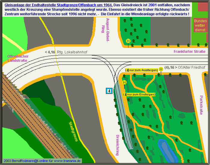
| Baden-Württemberg |
Freiburg im Breisgau | Heilbronn | Karlsruhe ( tram and light rail ) | Kehl (Strasbourg) | Heidelberg | Mannheim | Stuttgart | Ulm | Weil am Rhein (Basel) |
|
| Bavaria | ||
| Berlin | ||
| Brandenburg |
Brandenburg an der Havel | Cottbus | Frankfurt (Oder) | Potsdam | Schöneiche near Berlin | Strausberg | Woltersdorf |
|
| Bremen | ||
| Hesse |
Darmstadt | Frankfurt am Main ( tram and light rail ) | Kassel ( tram and RegioTram ) |
|
| Mecklenburg-Western Pomerania | ||
| Lower Saxony | ||
| North Rhine-Westphalia |
Bielefeld | Bochum / Gelsenkirchen ( tram and light rail ) | Bonn | Dortmund | Duisburg ( tram and light rail ) | Düsseldorf ( tram and light rail ) | Essen ( tram and light rail ) | Cologne | Krefeld | Mülheim / Oberhausen |
|
| Rhineland-Palatinate | ||
| Saarland | ||
| Saxony |
Bad Schandau | Chemnitz | Dresden | Goerlitz | Leipzig | Plauen | Zwickau |
|
| Saxony-Anhalt |
Dessau | Halberstadt | Halle (Saale) | Magdeburg | Naumburg (Saale) |
|
| Thuringia |
Erfurt | Gera | Gotha | Jena | Nordhausen |