
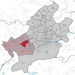
Frankfurt-Nied
 37th district of Frankfurt am Main |
|
|---|---|
  |
|
| Coordinates | 50 ° 5 '59 " N , 8 ° 33' 53" E |
| surface | 3.708 km² |
| Residents | 19,973 (Dec. 31, 2019) |
| Population density | 5386 inhabitants / km² |
| Post Code | 65934 |
| prefix | 069 |
| Website | www.frankfurt.de |
| structure | |
| District | 6 - West |
| Townships |
|
| Transport links | |
| Train | S1 S2 |
| tram | 11 21 |
| bus | 51 54 59 n8 |
| Source: Statistics currently 03/2020. Residents with main residence in Frankfurt am Main. Retrieved April 8, 2020 . | |
Nied has been part of Frankfurt am Main since April 1, 1928 .
The population is 19,973.
Geographical location
Nied is about 9.5 km west of the Frankfurter Hauptwache , north of the Main on the lower reaches of the Nidda River at an altitude of 98 m above sea level . The settlement shows a regular floor plan in the angle of the river Main and Nidda with the Christ Church in a central location. Modern settlement development has advanced eastwards towards Griesheim and Frankfurt city center. Neighboring districts of Nied are Höchst in the west , Sossenheim in the north, Griesheim in the east and Schwanheim in the south across the Main .
history
Prehistory and early history
Around 3000 BC There were Neolithic settlements on the Main and Nidda , also in Nied ( Bandkeramische Zeit). Around 800 BC There was a Celtic settlement with subsequent Germanic landings around the time of Christ's birth. In pre-Roman times, an old road ran here - the Antsanvia (Antiana Via), which led through the Nieder Wald in accordance with the course of the later Rödelheimer Straße and Oeserstraße.
The first Roman settlement in Nied goes back to the Chat Wars of Emperor Domitian , in which the Roman province Germania superior (province Upper Germany) with the capital Mogontiacum ( Mainz ) was created. In the years 83 and 84 (Chattenkrieg, revolt of Saturninus , Emperor Domitian) the Romans penetrated the Nidda up into the Wetterau and founded the city of Nida as civitas (district capital) . In Nied, the remains of a Roman Niddabrücke and large central brickworks were found that supplied the entire Wetterau and the Limes (see the street name Im Ziegelfeld, known as Römerstrasse until 1928 ). The brickworks were operated by members of three Roman legions : Legio VIII Augusta , Legio XXI Rapax and Legio XXII Primigenia Pia Fidelis . Pottery was also produced for the regional supply of the Civitas Taunensium with its main town Nida. The sound was made by the Romans. Extracted from the mines in Kelkheim-Münster and transported to Nied on carts. Oil lamps for regional needs were manufactured in Lucius' workshops. These goods were transported by barges along the Nidda to the small port in Nida - at that time a transshipment point for all trade in the region. The Roman settlement (vicus) was militarily protected by the nearby Roman fort in Frankfurt-Höchst . Individual villae rusticae (Roman manors) along the Nidda and a mansio (Roman rest stop) in the Niederwald have also been identified. This Roman building complex, located on the later Via Regia, was known as the "Heidenschloß". On the district map from 1870 there are traces of Roman buildings in the corridors “Römerberg”, “Im Kremser”, “Am Heidenschloss” and a “Römerthurm” in the corridor “Lange Wiesen” on the Nidda. Many ancient finds from Nied ended up in the museums in Frankfurt, Darmstadt, Wiesbaden and Frankfurt-Höchst. A special find is a Fortuna Altar, which is now in the Wiesbaden Museum. During excavations in Nieder Kirchweg in 2003, Roman graves were discovered. In 2012, further valuable bricks with Roman scripts and a very well-preserved kiln were archaeologically uncovered during construction work. In 2018, in the construction pit at the “Nieder Loch” in Alt-Nied, “vast amounts of Roman clay bricks were found, as well as a kind of counterfeiter's workshop from the 3rd century AD, when the power of the Romans in today's Rhine-Main area was already crumbling”.
Around 260 AD the so-called Alemanni storm led to the Limes fall and the conquest of the main town of Nida. The traces of the Roman Nied were lost in the centuries that followed. An archaeological commission researched for the first time in 1834 at the Wörthspitze for the ancient monument “Monumentum Trajanum”, the remains of which are said to have been at the confluence of the Nidda and Main rivers.
middle Ages


The Franconian conquest of the land took place around 500 AD , and in 770 AD the Niddagau was first mentioned, to which Nied belonged in the High Middle Ages . Around 817 AD, a Fiscus Franconofurt, a royal domain, to which Nied also belonged, was mentioned.
The Diehl families had been farmers in Nied since 1105 AD. A parish was first mentioned in Nied in 1160 AD. Around 1200 AD, the Frankfurt Treasury disintegrated. The Bornheimerberg court and the later Bornheimerberg office , to which Nied belonged , also formed from the relict areas . The oldest surviving document of the place comes from Archbishop Siegfried II of Mainz from February 21, 1218, whereby a church in the village is also mentioned. The parish included Griesheim , Sossenheim , Breitenloch - a village between Sossenheim and Rödelheim that went under in 1619 - and in 1274 also the Biegen desert , a village with a castle belonging to the Lords of Biegen in 1295. The middle church authority was the archdeaconate of the provost of St. Peter in Mainz , deanery Eschborn . In 1268 the monastery of St. Maria ad Gradus in Mainz ruled the village. In 1474 and again in 1485 the monastery handed over the villages of Nied and Griesheim with high and low jurisdiction to the Mainz ore monastery .
After the deposition of the Hohenstaufen emperor Friedrich II , the battle of the Nidda near Nied took place on August 5, 1246 . Friedrich's son Konrad IV and his rival king Heinrich Raspe of Thuringia fought for the succession to the throne.
In 1320 King Ludwig IV pledged the Bornheimerberg - and also Nied - to Ulrich II. Von Hanau . In 1351 Emperor Charles IV renewed this pledge for Hanau. In 1434, Count Reinhard II von Hanau was enfeoffed with the Bornheimerberg by Emperor Sigismund . When the County of Hanau was divided in 1458, the Bornheimerberg became part of the County of Hanau-Münzenberg . The local rule was thus disputed between the Electorate of Mainz and the County of Hanau. The electorate assigned the village to its office in Höchst . In 1489 the building of a stone church was ordered.
A wooden bridge over the Nidda is first documented in 1275. Bridge tolls were raised from 1342. Around 1410, Emperor Sigismund confirmed to the city of Frankfurt their rights to this bridge, which they maintained for the safety of travel to the Frankfurt Trade Fair . The bridge also turned the fishing village into a resting place on the trade route from Mainz to Frankfurt.
The village was protected by trenches with fences and two huge trap gates. The fortified church tower shaped the townscape. The wayside shrine for St. Wolfgang was located below the Niddabrücke (today's Kerbplatz) . In the direction of Höchst there were once wine fields, on the banks of the Main between Nied and Griesheim a little wood on the heath and a Jewish cemetery - today an industrial site. From 1438, Nied owned Burgrecht in Frankfurt, that is, its residents found refuge behind the city wall in troubled times.
Historical forms of names

The place name originally comes from the Celtic and is related to the river Nidda.
- Nide (1035, assignment doubtful)
- Nitha (around 1150)
- Nithe (1218)
- Nithe (1223)
- Niede (1268)
- Nyeda (1271)
- Niede (1274)
- Nide (1274)
Early modern age

In 1592 the ore monastery pledged its share in the villages of Griesheim and Nied to the Counts of Hanau. In 1684 Kurmainz and Hanau exchanged a number of rights in condominiums and areas of similar mixed claims. In the process, Nied fell to Mainz.
In the middle of the 16th century, the Reformation in Nied was introduced in the Lutheran style by the Counts of Hanau . In a "second Reformation" the denomination of the County of Hanau-Munzenberg was changed again: From 1597 Count Philipp Ludwig II pursued a decidedly reformed church policy and made use of his Jus reformandi - with this right to determine the denomination of his subjects as sovereign, he enforced Calvinism as binding for his county to a large extent - but not in Nied. Under the protection of Mainz, not all subjects took part in this second change of denomination and a Roman Catholic portion of the population remained. Decades of denominational disputes broke out between Lutherans, Calvinists and Catholics. However, in 1828 the three denominations finally shared the one existing church building as a simultaneous church , until their own Protestant hall church was built in classicist style in 1908 and a tower was added (today: Protestant Christ Church). In 1906/07 the Roman Catholic St. Mark's Church was built.
During the Thirty Years War , Nied was destroyed several times, including by the troops of Duke Christian von Braunschweig . In June 1622, the Battle of Höchst took place here, in which the Catholic League under Count Tilly and Gonzalo Fernández de Córdoba met the Protestant Union (the street names Tillystrasse and Schwedenpfad remind us of this). Landsknechte abducted the residents. In 1648 the place still had "five neighbors and a few single people" . In 1693, 28 families lived in Nied again, including 13 farmers and 7 fishermen, and services according to the Roman Catholic rite were held in the ruins of the church.
In 1787, the Electorate of Mainz assigned the village of Nied to its Oberamt Höchst and Königstein, and there the district bailiwick of Höchst.
Modern times

.jpg)
During the First Coalition War , Nied was also looted by the imperial troops in 1795. Again and again the Nidda Bridge was of strategic importance for the warring parties. Around 1800 the second estuary of the Nidda (today: Wörthspitze ) and the Haingraben surrounding the village were filled in. In 1803, Nied fell to the Principality of Nassau-Usingen in the Reichsdeputationshauptschluss (from 1806: Duchy of Nassau ). Here it also belonged to the Oberamt Höchst and Königstein and to the Amtsvogtei Höchst. During the Napoleonic period, Nied was occupied by the French. In 1812 the French Empress Marie Louise stopped by the Schultheis von Nied. She accompanied her husband Napoleon Bonaparte on his campaign to the east. From October 28th to 30th, 1813, Napoleon and the French "Grande Armée" withdrew over the Nidda Bridge near Nied. From 1816 to 1866, Nied was again part of the Duchy of Nassau and here assigned to the Office of Höchst.
In 1824 the wooden bridge was replaced by a stone bridge over the Nidda. The sandstone construction with six wide flood arches has withstood every flood of the Main and Nidda to this day. A memorial stone (made of Lahn marble ) commemorates the reconstruction after the destruction by the French.
As an ally of Austria, the Duchy of Nassau was defeated by the Kingdom of Prussia in the Austro-Prussian War in 1866 . This then annexed the duchy and thus also Nied. From 1867, Nied therefore belonged to the Prussian Province of Hesse-Nassau , the Wiesbaden administrative district and the Wiesbaden district , and from 1886 to 1928 the Höchst district .
In 1838 the Taunus Railway was run through the Nieder district. Since 1879, the Frankfurt – Limburg railway line further south has been put into operation by the Hessian Ludwig Railway (HLB). But it was not until 1888 that Nied received its own stop for local transport and in 1915 a station building (train station).
Since the 20th century


From 1902 the Nieder Zeitung was published. In 1905 the villa quarter was created "to attract better taxpayers" . The imperial post administrator Josef Benner wrote the first chronicle of the village of Nied am Main in 1910.
When the Prussian State Railways opened the Royal Prussian steam locomotive repair plant in Nied and built a railway settlement (Nied-Nord) in 1918 , there was a significant influx - mainly from southern Germany. The plant employed hundreds of people. The settlement is one of the few in Germany living monuments still preserved in their original style and stands as a cultural monument by the Hessian Denkmalschutzgesetz under monument protection .
After the First World War , Nied was part of the French zone of occupation from 1918 to 1930. In 1928/29 the lower course of the Nidda was regulated by straightening and weirs, which resulted in five Nidda oxbow lakes in the Nieder district - Grillscher Altarm, Waldspitze, Kellerseck, Wiesengraben and Rondell.
Ferdinand Scholling (1867–1952) was the last mayor of the community of Nied, which was independent until 1928. On April 1, 1928, Nied was incorporated into the city of Frankfurt am Main. Old street names were replaced by new names, so Frankfurter Strasse was renamed Mainzer Landstrasse and Rödelheimer Strasse was renamed Oeserstrasse .
During the time of National Socialism , the NSDAP inaugurated a Thingplatz at the Wörthspitze in April 1934 . In 1937 a memorial was erected here, which was demolished in 1965 and whose remains on the banks of the Main are now used as a viewing platform and playground. A memorial column has been erected on Kahnplatz in front of the cemetery for the victims of National Socialism . So far, 13 stumbling blocks have been laid in Nied for victims named Bender, Salomon, Hirsch, Kahn, Herger and Heps.
After the Second World War , the US armed forces controlled traffic to Schwanheim on a rotating wooden bridge (emergency bridge) over the Main, which was replaced by the new Schwanheimer bridge in 1963.
The depot had to give way to changed operating conditions and was shut down in 1967. Temporarily occupied in 1981, it was demolished after the police evacuated it. The area was built on with residential houses. This expansion of the railway settlement, the construction of the Parkstadt, Nied-Süd, Nied-Ost settlements and the development of the former repair shop on Oeserstraße more than tripled the residential area of the district.
From 2012 the Nidda was renatured and the Höchst Weir and its straightened section were built back. The rapids created there with a newly created island enable the fish from the Main to rise back into the Nidda and spawn there. A new pedestrian bridge was built across from the Sulzbach. Since then, the popular “Niddastrand” for leisure and relaxation has also been located directly at the Nieder Polo facility.
Since the end of 2018, a new living area has been under construction on Mainzer Landstrasse on the so-called "Nieder Loch / Alt-Nied", which provides 131 apartments in passive construction and a large supermarket.
Population development

On December 31, 2019, Nied had 19,973 inhabitants
Population structure:
Of the 19,973 inhabitants, 9,862 were female (49.4%) and 10,111 were male (50.6%). 12,501 were Germans (62.6%) and 7,472 foreigners (37.4%). Of these, 3,444 were from the EU (46.1%) and 4,028 were not from the EU (53.9%).
| 1580: 120 inhabitants | 1858: 670 inhabitants | 1928: 8,673 inhabitants |
| 1620: 160 inhabitants | 1864: 776 inhabitants | 1939: 8,326 inhabitants |
| 1651: 70 inhabitants | 1871: 940 inhabitants | 1946: 9,198 inhabitants |
| 1668: 90 inhabitants | 1875: 1,035 inhabitants | 1950: 10,191 inhabitants |
| 1736: 230 inhabitants | 1885: 1,476 inhabitants | 1961: 10,086 inhabitants |
| 1808: 273 inhabitants | 1895: 2,179 inhabitants | 1970: 14,118 inhabitants |
| 1834: 424 inhabitants | 1900: 4,028 inhabitants | 1976: 14,720 inhabitants |
| 1840: 491 inhabitants | 1905: 5,485 inhabitants | 2014: 18,853 inhabitants |
| 1846: 535 inhabitants | 1910: 7,491 inhabitants | 2015: 19,398 inhabitants |
| 1852: 616 inhabitants | 1925: 8,597 inhabitants | 2016: 19,387 inhabitants |
traffic
Since 1888 there are in Nied a breakpoint of the Main-Lahn Railway . Nied has been connected to the Frankfurt tram network since 1935 and to the Rhein-Main S-Bahn since 1978 . At the height of the pedestrian bridge between Nied-Ost and the new building area / railroad settlement, the new “Nied-Ost” station for regional traffic is to be built with the approval of the Transport Committee of the City of Frankfurt am Main. For decades, the Oeserstraße level crossing at the level of Niddahalle / Birminghamstraße has been an unsolved traffic problem - during rush hour traffic there is considerable traffic jam. This often disrupts the process on bus route 59, resulting in considerable delays and cancellations. So-called barrier festivals are intended to point out the grievances. A solution that is satisfactory for all parties remains to be seen.
Attractions


In the nearby Niedwald there is the freely accessible Selzerbrunnen, a mineral fountain whose water is drinkable, but contains a high proportion of hydrogen sulfide . A second sulphurous mineral well (Faulbrunnen) is located within the railway workers' settlement in the street Brunnenpfad . "Faulbrunnen" is the name given to springs whose water has an unmistakable smell of rotten eggs due to hydrogen sulfide and whose water is also used as medicinal water for skin diseases. The Faulbrunnen in Nied was already praised in the balneological literature with extensive healing indications at the end of the 16th century. The commercial use and the dispatch of "Nieder Schwefelwasser" had to cease to compete with the Weilbacher Schwefelbrunnen. Before the incorporation, a possible spa and spa operation was considered.
Various nature conservation measures on the Nidda, on the oxbow lakes and in the Niedwald make this forest floodplain landscape a popular destination for recreation and excursions.
In the west of the district in the direction of Höchst lies the Wörthspitze , a large park that is located on a former estuary island between the Main and Nidda. It is part of the Frankfurt green belt .
In the town hall on the Niddabrücke, which was built in 1840 and rebuilt and expanded in 1908, a police station is now set up. The Nied railway bridge of the Taunus Railway over the Nidda, which has been in use since 1839, is one of the oldest railway bridges still in operation in Germany (sandstone construction from 1838). The bridge was renovated in 2018.
The Nied Heimatmuseum in Beunestrasse 9a shows relics of the former Roman central brick, the products of which were mainly manufactured for the Limes fortifications of the Upper Germanic army.
See also: List of cultural monuments in Frankfurt-Nied
Associations and institutions
In the Frankfurt am Main.-Nied e. V. currently 51 associations are organized. The fishing club Nied 1920 e. V., based on the Altarm Kellerseck, uses the fishing grounds in the Nidda and the oxbow lakes. The recreational area of the Orplid-Frankfurt nudist association is located on an "island" on the Niedwald forest formed by Nidda and the Waldspitze arm. 1986 Opening of the Nieder Heimatmuseum. The Frankfurt Polo Club , located on the grounds of the Georgshof equestrian center (formerly the Diehl family), offers polo events in summer that have become known beyond the Frankfurt area. The city of Frankfurt am Main acquired the 40 hectare agricultural area in 2019. In the summer there is a regular beach handball tournament at the Niddahalle , tennis courts and archery facilities are also available. In terms of sport, Nied is primarily known through the Sportgemeinschaft 1877 Frankfurt-Nied e. V. This is five times German trampoline gymnastics champion (most recently 2001). In addition, many successful individual gymnasts such as Markus Kubicka , who became world champion in team jumping in 2003 and European champion in synchronized jumping in 2002, were among its members. In the carnival season, the NCC offers variety in the cold season. Alemannia Nied football events take place at the sports field in Nied-Ost.
The fire and rescue station 3 is located in Nied . The Frankfurt am Main - Nied volunteer fire brigade is located on the same property, but with a different address.
Religious communities
- two Protestant parishes with the Christ Church and the Apostle Church
- two Catholic parishes with the Church of Trinity and St. Mark's Church
- other beliefs
Educational institutions
- Fridtjof Nansen School
- Friedrich List School
- Nidda school
- Panorama school, school for the practically imaginable
Sports facilities
- Niddahalle / Niddakampfbahn
- Sports facility on Denisweg (football club FV Alemannia 08 Nied)
- Polo field at Georgshof ( Frankfurter Polo Club )
Personalities
Personalities who were born in Nied
- Christian Gollong (1901–1988), actor
- Valentin Jost (1920–2007), politician ( SPD ), district administrator of the Main-Taunus district
Personalities who temporarily lived or worked in Nied
- Carl Wolf (1834–1901), Roman Catholic pastor and member of the Reichstag of the German Empire
- Georg Heck (1897–1982), painter and graphic artist of Expressionism and New Objectivity
- Dietrich Mattausch (* 1940), actor
- Julia Kröhn (* 1975), Austrian novelist and television journalist
- Joscha Sauer (* 1978), creator of the Nichtlustig comics
- Jasmin Siddiqui (* 1981), member of the street artist duo Herakut
literature
- Gerd Bethke: Main-Taunus-Land. Historical local lexicon - wheel and rafter; 26. 1996, pp. 137-141.
- Günter Christ: Handbook of Mainz Church History . 2: Archbishopric and Archdiocese of Mainz. Territorial and Church Structures - Contributions to Mainz Church History 6.2. 1997, pp. 93, 295-296.
- Margarete Dörr: The St. Mariengredenstift in Mainz. History, Law and Property . 1953, pp. 231-233.
- Gerhard Kleinfeldt, Hans Weirich: The medieval church organization in the Upper Hesse-Nassau area - writings of the Institute for historical regional studies of Hesse and Nassau 16 (1937). ND 1984, p. 71.
- Anette Löffler: The Lords and Counts of Falkenstein (Taunus): Studies on territorial and property history, on imperial political position and on the genealogy of a leading ministerial family; 1255-1418. - Sources and research on Hessian history 99. Volume 1. Darmstadt 1994, ISBN 3-88443-188-9 , pp. 371–372.
- Regina Schäfer: The Lords of Eppstein - Publications of the Historical Commission for Nassau, Wiesbaden 2000, p. 72, 424.
- Heinz Schomann among others: Monument topography city of Frankfurt am Main . Braunschweig 1986, pp. 622-629.
- Christian Daniel Vogel : Description of the Duchy of Nassau . 1843, p. 864.
- Adalbert Vollert: Nied am Main. Chronicle of a Frankfurt district. Frankfurt am Main 1998: Local history and history association Nied.
- Ingeborg Huld-Zetsche: The lamps from the Roman pottery in Frankfurt am Main-Nied. Schnell + Steiner, Regensburg 2014, ISBN 978-3-7954-2838-9 .
- Andrea Hampel: The Roman military brick in Frankfurt am Main.-Nied - New excavations. In: Landesamt für Denkmalpflege Hessen (Ed.): Hessen-Archäologie 2012. Yearbook for Archeology and Palaeontology in Hessen, pp. 115–120.
Web links
- "Nied, City of Frankfurt am Main". Historical local dictionary for Hessen. In: Landesgeschichtliches Informationssystem Hessen (LAGIS).
- Literature about Frankfurt-Nied in the Hessian Bibliography
- My district - my home on YouTube
Individual evidence
- ^ Andrea Hampel and G. Wetter: The Roman legionary brick in Frankfurt am Main-Nied. (PDF) In: Newsletter of the German Limes Commission, Volume 8 · 2014 · Issue 1, pp. 26–30. German Limes Commission, UNESCO, January 1, 2014, accessed April 13, 2019 .
- ^ Ingeborg Huld-Zetsche: The lamps from the Roman pottery of Frankfurt am Main-Nied. Retrieved February 3, 2018 .
- ^ Association ring Nied: Nied in the course of time. (PDF) In: District Brochure 2009. October 1, 2009, accessed on February 3, 2020 .
- ↑ Holger Vonhof: The Nieder Loch should fill up - groundbreaking for 75 rental apartments. FNP, December 7, 2018, accessed May 4, 2019 .
- ^ Hofrat Johann Wilhelm Christian Steiner: History and topography of the Main region and Spessart under the Romans, S-139-142. In: Annals of the Association for Nassau antiquity. Self-published, 1834, accessed July 1, 2018 .
- ^ Frankfurter Neue Presse: Local farmer and local advisory board member Georg Diehl died at the age of 63. FNP, July 17, 2018, accessed July 19, 2018 .
- ↑ History Association Nied: Festschrift 800 years. (PDF) May 29, 2015, accessed May 29, 2018 .
- ^ Association ring Nied: Commemorative publication 800 years of Nied. (PDF) Vereinsring Nied, accessed on March 10, 2018 .
- ^ Hans Wertheim: The great Halberstadt Duke Christian of Braunschweig in the Palatinate War 1621-1622. A section from the Thirty Years' War. 2 volumes. International Library Berlin, Berlin 1929.
- ↑ Vereinsring Nied: Festschrift 800 Jahre Nied p. 29. (PDF) Vereinsring Nied, February 1, 2018, accessed on February 3, 2020 .
- ^ Rhein-Main-Taunus Online Magazine: Napoleon's Grand Armée ... Kriftel. Rhein-Main-Taunus Online Magazin, February 11, 2014, accessed on February 3, 2020 .
- ^ Chronicle of Nied at frankfurt.de , as of Feb. 20, 2020.
- ^ The social conditions in the country and some advice for improving them, 1894; Chronicle of the village of Nied am Main, 1910. Rhineland-Palatinate personal database, December 15, 2010, accessed on April 12, 2019 .
- ↑ City of Frankfurt am Main, Environment Agency: The Green Belt Leisure Card. 7th edition. 2011.
- ↑ Frankfurt-Zoom. Where do you live? Facts about your street. Retrieved October 30, 2018 .
- ↑ Renaturation of the Nidda: Rest by the river and protection by the pond. Frankfurter Allgemeine Zeitung GmbH, August 21, 2016, accessed on December 4, 2017 .
- ↑ Clemens Dörrenberg: 131 apartments are being built in Alt-Nied. In: FR.de (Frankfurter Rundschau). December 7, 2018, accessed March 1, 2019 .
- ↑ City of Frankfurt am Main: Population 2019, FSA 2020/03. (PDF) City of Frankfurt am Main, March 1, 2020, accessed on April 9, 2020 .
- ↑ City of Frankfurt am Main: Frankfurt Statistics Current (FSA) 2020/03. (PDF) City of Frankfurt am Main, December 31, 2019, accessed on April 9, 2020 .
- ↑ Statistical Yearbook 2014 in pdf, accessed on Feb. 26, 2020.
- ↑ Statistical Yearbook 2015 in pdf, accessed on Feb. 26, 2020.
- ↑ Statistical Yearbook 2016 in pdf, accessed on Feb. 26, 2020.
- ^ Frankfurter Rundschau, Florian Leclerc: New station Nied-Ost is being built. February 20, 2018, accessed March 3, 2019 .
- ↑ Frankfurter Rundschau: Nied: Protest at the level crossing. FRI, October 15, 2019, accessed October 18, 2019 .
- ↑ Hessenschau.de: Train records pedestrians, cyclists and cars. May 8, 2020, accessed May 8, 2020 .
- ↑ Frankfurter Rundschau, George Grodensky: Waiting for the subway. July 12, 2017, accessed March 3, 2019 .
- ^ Institute for City History Carmelite Monastery Frankfurt am Main: Unfulfilled Dreams - Bad Nied? Dr. Konrad Schneider, June 21, 2016, accessed April 9, 2020 .
- ^ Association ring Nied associations. Vereinsring Nied, March 12, 2019, accessed on May 18, 2019 .
- ↑ Vereinsring Frankfurt-Nied: District Brochure 2016. (PDF) Retrieved on December 7, 2017 .
- ↑ City acquires Georgshof with 40 hectares of land. City of Frankfurt am Main, December 23, 2019, accessed on January 5, 2020 .
- ^ Frankfurt fire brigade
- ↑ eknied.de
- ↑ kath-kirche-nied.de
- ↑ comunita-italiana-ffm.de
- ↑ fraccf.de
- ^ City of Frankfurt am Main: Churches and religious communities. Retrieved March 8, 2019 . (Page not found on Feb. 20, 2020)
Old town | Bahnhofsviertel | Bergen-Enkheim | Berkersheim | Bockenheim | Bonames | Bornheim | Thorn bush | Eckenheim | Eschersheim | Fechenheim | Airport | Frankfurter Berg | Gallus | Ginnheim | Griesheim | Gutleutviertel | Harheim | Hausen | Heddernheim | Highest | Downtown | Kalbach-Riedberg | Nied | Nieder-Erlenbach | Nieder-Eschbach | Niederrad | Niederursel | Northrend-East | Northrend-West | Upper wheel | Ostend | Praunheim | Preungesheim | Riederwald | Rödelheim | Sachsenhausen-North | Sachsenhausen-South | Schwanheim | Seckbach | Sindlingen | Sossenheim | Unterliederbach | Westend-North | Westend-South | Zeilsheim
Inner city I (01) | Inner city II (02) | Inner city III (03) | Bornheim / Ostend (04) | South (05) | West (06) | Middle-West (07) | North-West (08) | Center-North (09) | North-East (10) | East (11) | Kalbach / Riedberg (12) | Nieder-Erlenbach (13) | Harheim (14) | Nieder-Eschbach (15) | Bergen-Enkheim (16)