
Frankfurt Airport
|
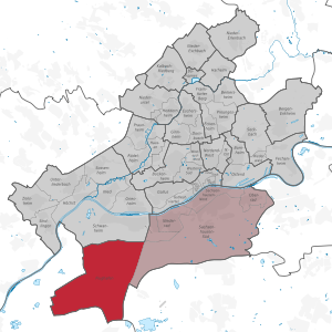
15th district of Frankfurt am Main |
|
|---|---|
  |
|
| Coordinates | 50 ° 3 '40 " N , 8 ° 33' 51" E |
| surface | 24.176 km² |
| Post Code | 60549 |
| prefix | 069 |
| Website | www.frankfurt.de |
| structure | |
| District | 5 - south |
| Townships |
|
| Transport links | |
| Highway |
|
| Federal road |
|
| Regional and S-Bahn | 55 80 S8 S9 |
| bus | 58 61 62 77 X17 GG-72 GG-73 OF-64 OF-67 651 n7 n72 n751 n81 |
Frankfurt Airport is an independent district of Frankfurt am Main . It was created through outsourcing from the Sachsenhausen-Süd district and is usually assigned to this in statistical evaluations. The population is given on the city's website as 211 people. This makes it the least populated district, but the second largest in terms of area. The district is divided into the Unterwald districts north of the B 43 and the airport south of the Autobahn 3 , with the Gateway Gardens district in between .
Because of the Frankfurt airport , the district has a corresponding infrastructure , despite the small number of inhabitants : In addition to the airport itself, it has a hospital, the two train stations airport long-distance train station and regional train station as well as the S-Bahn station Gateway Gardens , the two fully automatic elevated railways SkyLine and Skylink , sacred buildings of all world religions , several restaurants and hotels. In addition, it provides work for around 81,000 people, making it the largest local workplace in Germany. From 2016, a new urban quarter was also built under the name Gateway Gardens on the site of a former US military settlement.
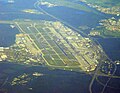
Frankfurt Airport from the air

Frankfurt Airport sign near Gate 21


Individual evidence
- ↑ Frankfurt Statistics Current (FSA) at par.frankfurt.de , the former website of the city of Frankfurt am Main
- ↑ a b airport at par.frankfurt.de , the former website of the city of Frankfurt am Main (page cannot be found on Feb. 20, 2020)
Web links
Old town | Bahnhofsviertel | Bergen-Enkheim | Berkersheim | Bockenheim | Bonames | Bornheim | Thorn bush | Eckenheim | Eschersheim | Fechenheim | Airport | Frankfurter Berg | Gallus | Ginnheim | Griesheim | Gutleutviertel | Harheim | Hausen | Heddernheim | Highest | Downtown | Kalbach-Riedberg | Nied | Nieder-Erlenbach | Nieder-Eschbach | Niederrad | Niederursel | Northrend-East | Northrend-West | Upper wheel | Ostend | Praunheim | Preungesheim | Riederwald | Rödelheim | Sachsenhausen-North | Sachsenhausen-South | Schwanheim | Seckbach | Sindlingen | Sossenheim | Unterliederbach | Westend-North | Westend-South | Zeilsheim
Inner city I (01) | Inner city II (02) | Inner city III (03) | Bornheim / Ostend (04) | South (05) | West (06) | Middle-West (07) | North-West (08) | Center-North (09) | North-East (10) | East (11) | Kalbach / Riedberg (12) | Nieder-Erlenbach (13) | Harheim (14) | Nieder-Eschbach (15) | Bergen-Enkheim (16)