
Frankfurt-Gallus
|
11th district of Frankfurt am Main |
|
|---|---|
  |
|
| Coordinates | 50 ° 6 '13 " N , 8 ° 38' 44" E |
| surface | 4.517 km² |
| Residents | 41,851 (Dec. 31, 2019) |
| Population density | 9265 inhabitants / km² |
| Post Code | 60325, 60326, 60327, 60329 |
| prefix | 069 |
| Website | www.frankfurt.de |
| structure | |
| District | 1 - downtown I. |
| Townships |
|
| Transport links | |
| Train | S3 S4 S5 S6 |
| tram | 11 14 21 |
| bus | 34 46 50 52 n8 |
| Source: Statistics currently 03/2020. Residents with main residence in Frankfurt am Main. Retrieved April 8, 2020 . | |


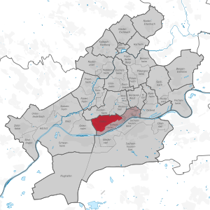
The Gallus (officially Gallusviertel until 2007 ) is a district of Frankfurt am Main .
The population is 41,851.
Location and demarcation
The district extends north of the Main and borders the Bahnhofsviertel in the east, the Gutleutviertel in the south, Griesheim in the west, Bockenheim in the north with the Rebstock site and in the northeast on Westend-Süd with the exhibition grounds .
The Frankfurt Central Station , the largest German railway junction is one, as is the Gallus as one of the largest construction sites of Frankfurt, the European quarter on the site of the former main freight depot .
Economy and Infrastructure
Since the construction of the main train station, the Gallus has been a district shaped by industrial and craft businesses. The oldest plants are the Adlerwerke in Kleyerstrasse and iron foundry Mayfarth & Co. In addition, played craft shops like the J. & CA Schneider ICAS (slipper manufacturing) , the brakes factory Alfred Teves (ATE) and the German private telephone company H. Fuld & Co ( later telephone construction and normal time , Telenorma or T&N for short ) played a major role. In the post-war period, car dealerships were important on Mainzer Landstrasse, but they are now largely located on Hanauer Landstrasse .
The Neue Hellerhofsiedlung and the Friedrich-Ebert-Siedlung as typical workers' settlements were designed and built for the employees in these companies under the direction of the building councilor Ernst May .
For decades, there was hardly any urban development in the Gallus due to its unfavorable 'trapped' location between the track apron of the main train station and the tracks of the main freight station. With the abandonment of the main freight station by Deutsche Bahn in 1996, completely new options arose for the district. Since 2006, the Europaviertel has been built here on the former track area as a lively district with office buildings, apartments, shops, hotels and parks. At the beginning of 2012, the 200-meter skyscraper Tower 185 was completed near the trade fair . In August 2013, after a two-year construction period, the large-scale Skyline Plaza shopping center was opened in the eastern Europaviertel, followed by the Kap Europa congress center in May 2014 .
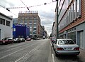
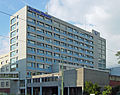
As an economic axis, the Mainzer Landstrasse runs straight through the city district. After the disappearance of production and handicrafts, a considerable number of service industries (publishing and securities trading as well as large areas of Commerzbank AG with its service center ) have moved into new buildings since 2000 . The central passenger traffic of Deutsche Bahn AG is located next to the site of the former railway repair shop south of the fair. In addition, the Gallus houses the publishing and editorial building of the Frankfurter Allgemeine Zeitung .
Some streets are considered to be socially disadvantaged due to the different lives of the residents ( welfare , immigration , drug or alcohol abuse ). For this reason, too, the Gallus has been included in the Socially Integrative City project . As part of this federal-state program, projects in the district are implemented without great bureaucratic effort (provided that they comply with the project's provisions).
history
Historically, the Gallus is the former gallows field west of the medieval city limits of Frankfurt. The name is derived from the Galluswarte (actually Galgenwarte ), one of the four medieval waiting towers in the city. The name of the district originally had nothing to do with St. Gallus , but the name was changed towards the end of the 18th century to rob the area of its dubious reputation. A newly built Catholic church in this district in 1905 is also dedicated to Saint Gall.
Historically, the district is a mixed area. In addition to production and handicrafts, transport played a major role, but the abandonment of the freight yard made it less important. On the other hand, Frankfurt Central Station, which was built in 1880, is still a landmark.
During the Second World War , this district was also the target of Allied air raids , as on December 29, 1944, when it came to severe destruction.
In June 2006, on the initiative of the Green Group, the Gallus local council decided unanimously to use the name Gallus as the official designation in future and to dispense with the additional quarter , on the grounds that this designation had long been in line with common usage. On April 3, 2007 this decision was officially implemented.
"Cameroon"
Since the turn of the century before last, the then new building area west of the Galluswarte, often also the whole of Gallus, has been popularly referred to as " Cameroon ". Another part of the Gallus north of the Mainzer Landstrasse was called the Goi . A third old place name for a small new building area north of the Mönchhofstraße tram stop is Babbedeggelhausen . At that time (1905) there were 15,400 inhabitants in Gallus. Where these names come from is still not certain. There are different attempts to explain it:
- After the First World War , the border crossings on Mainzer Landstrasse were occupied by French occupation soldiers - Moroccan mercenaries. “Go to the Cameroonians” was the catchphrase when one was on the way from Gallus to these crossings.
- Another theory refers to the soot that settled from numerous chimneys on the district after industrialization . "Black as Cameroon" was then.
- Some also think that the district was so far away from the rest of the city population due to the industry and the settled working-class population that it was as far away as the German colony of Cameroon for the rest of the population .
- Another version refers to the Adler factories , where typewriters were made. After the shift, the workers often came out of the factory with their faces stained with typewriter paint and it is said that they were called "Cameroonians", also because of the popularity of the colonies of the time.
- Another theory refers to the former railway repair shop in Idsteiner Straße. Steam locomotives are said to have been ransacked there. The railway workers entrusted with this work then looked like "Cameroonians".
Culture and sights
The cultural places can be found in Gallus away from the main traffic artery Mainzer Landstrasse.
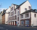
Probably the best known is the Gallus Theater in the former Adlerwerke in Kleyerstraße, which offers a stage for permanent ensembles as well as independent artists and groups. It is also known far beyond the city limits for its children's theater program.
There are also a number of independent initiatives - the Koblenzer Strasse district initiative is an example of this. In addition to cultural events and a bicycle workshop, there are a number of other projects to help shape and revitalize the district.
With Adlerwerke and Hauptbahnhof, the Gallus has two pioneering functional buildings of the industrial age . At the same time, the residential buildings of the Hellerhof estate were built by Ernst May as part of the New Frankfurt program . The machines of this age are preserved by the Hochhut Technical Collection and made accessible to the public. To this day, the influence of industrial culture has remained visible in many places in the district .
In the Henry Street is located after the demolition of the fire station 2 in Frankfurt's North with the fire station Gallus the oldest is located still operating fire station of Frankfurt.
There are also a number of stumbling blocks that are supposed to remind of the life of the Jews and other victims of Nazi persecution in Gallus.
schools
There are three primary schools in Gallus, the Ackermann School , the Günderrode School and the Hellerhof School. The Paul Hindemith School is an integrated comprehensive school . It was created in 1985 by merging the Rebstöckerschule , a secondary school, the Hufnagelschule , a Realschule and the support level of the Günderrodeschule .
Personalities
- Lia Wöhr (1911–1994) grew up in Gallus. The city of Frankfurt named a place on the edge of the Gallus after her and put a memorial stone there.
- Heinrich Kleyer (1853–1932) played a key role in establishing industry in Gallus as the founder and later as chairman of the board .
- Michael Thurk (* 1976) grew up in Gallus. His football career began with the district club FFV Sportfreunde 04 .
- Thor Kunkel (* 1963) grew up in Gallus. The plot of his novel The Black Light Terrarium takes place largely in this district.
- Lotte Specht (1911–2002) grew up in Gallus and in 1930 founded the first football club for women in Frankfurt. Later she organized the first dialect stage in Frankfurt.
photos
Gallus fire and rescue station (area control station 2) of the Frankfurt am Main fire brigade
Adlerwerke in Kleyerstrasse
Publishing house of the Frankfurter Allgemeine Zeitung
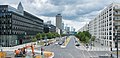
Eastern Europaallee in the Europaviertel

"Haus Gallus", scene of the 1st Auschwitz Trial , 1963–1965

Commerzbank skyscraper on Hafenstrasse

Gallows field with the gallows, 1782
(drawing by Johann Caspar Zehender )
The still largely undeveloped Gallus, 1893

St. Gallus Church in Gallus


See also
Web links
- My district - my home on YouTube
- District Advisory Board ( Memento from April 7, 2013 in the Internet Archive )
Individual evidence
- ^ Hans-Günter Stahl: The aerial warfare over the Hanau area 1939-1945 = Hanauer Geschichtsblätter 48. Hanau 2015. ISBN 978-3-935395-22-1 , p. 268.
- ↑ Homepage of the SIKS e. V. , accessed on August 13, 2008
Old town | Bahnhofsviertel | Bergen-Enkheim | Berkersheim | Bockenheim | Bonames | Bornheim | Thorn bush | Eckenheim | Eschersheim | Fechenheim | Airport | Frankfurter Berg | Gallus | Ginnheim | Griesheim | Gutleutviertel | Harheim | Hausen | Heddernheim | Highest | Downtown | Kalbach-Riedberg | Nied | Nieder-Erlenbach | Nieder-Eschbach | Niederrad | Niederursel | Northrend-East | Northrend-West | Upper wheel | Ostend | Praunheim | Preungesheim | Riederwald | Rödelheim | Sachsenhausen-North | Sachsenhausen-South | Schwanheim | Seckbach | Sindlingen | Sossenheim | Unterliederbach | Westend-North | Westend-South | Zeilsheim
Inner city I (01) | Inner city II (02) | Inner city III (03) | Bornheim / Ostend (04) | South (05) | West (06) | Middle-West (07) | North-West (08) | Center-North (09) | North-East (10) | East (11) | Kalbach / Riedberg (12) | Nieder-Erlenbach (13) | Harheim (14) | Nieder-Eschbach (15) | Bergen-Enkheim (16)