
Europaviertel (Frankfurt am Main)


The Europaviertel in Frankfurt am Main is a new downtown district that is being built on the site of the former main freight station in the Gallus district . Development work on the conversion area began in 2005, and the first building was opened in 2006. Upon completion, the urban development project should be built on with offices, hotels, apartments, a school and social infrastructure, parks as well as shopping and leisure opportunities. The completion of a subway connection is not planned for the year 2025. Around 30,000 people will work and 8,000 to 10,000 people will live in the entire Europaviertel. This ratio could shift in favor of the number of residents due to the increased demand for apartments since around 2012.
Size and location
The cleared area has a size of almost 90 hectares . Based on the two property owners, the area is subdivided into Europaviertel West and Europaviertel Ost ; the visually clearly recognizable border is the high-altitude railway line with the Emser bridge . In the western part, Aurelis Asset GmbH owns 66.7 hectares and in the eastern part 18 hectares belong to Vivico Real Estate GmbH (since June 2011: CA Immo ). The quarter now covers a total of 145 hectares including additional peripheral areas. The area stretches about 2.4 kilometers from the residential area on the Rebstock site and the Kuhwaldsiedlung in the north-west along the exhibition grounds to the Güterplatz in the south-east. In the south, the area is bounded by the Gallus Hellerhof estate.
history
In 1996, Deutsche Bahn decided to shut down the main freight station, the largest freight station in the city of Frankfurt, due to insufficient capacity utilization and to relocate the remaining freight activities, mainly container traffic, to the Ostbahnhof . In 1998, operations at the main freight station ceased. In 1999 the Frankfurt planning office Albert Speer & Partner (AS&P) prepared a master plan for the future development of the area on behalf of Deutsche Bahn. The usage concept envisaged shares of 25 percent each for residential areas, green areas, exhibition expansions and mixed areas for the derelict railway areas. A competing plan, which the architect Helmut Jahn conceived on behalf of the Deutsche Bank under the title Messestadt , was not pursued further because the Deutsche Bahn did not want to sell the core area. Initially, the neighboring Messe Frankfurt acquired 31,000 m² of space in order to be able to expand its site to the south. On the extension area a. a. from 2000 to 2001 the exhibition hall 3 and the new gate east.
Europaviertel Ost
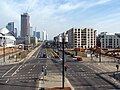
- August 2004: Start of construction on Europa-Allee
- May 2006: Completion of the Mövenpick Hotel
- November 2007: Groundbreaking for the first apartments on Europa-Allee
- January 2008: Contract between Vivico and Hyatt for a Grand Hyatt. In spring 2013 it was announced that the Hyatt Group had given up on the project. At this point south of Cape Europe there is a hotel today on a property that has been divided again; the southern skyscraper called Grand Tower (formerly "Tower 2") has been under construction since the beginning of 2016 and, at 172 meters, is Germany's highest pure residential property.
- September 2008: Groundbreaking for Tower 185
- October 2008: Groundbreaking of the office building at Europa-Allee 12–22
- November 2008: Start of construction of the Meininger Hotel
- July 2009: The first apartments are occupied in the Europaviertel
- February 2010: Meininger Hotel is completed
- High-rise One is under construction on the construction site north of Cape Europa , which will reach a height of 175 meters and should be completed in 2021.
- Building rights also exist for a z. Currently not current project, the up to 369 meter high Millennium Tower .
- Construction progress in the Eastern European Quarter

2008

2010
2011
2013


Europaviertel West - Aurelis construction activities
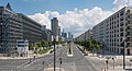
The 66.7 hectare part of the development area to the west of the Emser Bridge was cleared of old track systems by Aurelis by mid-2010, debris removed and developed. During 18 months of work, around 300,000 cubic meters of material were moved and newly installed. Aurelis began marketing its site in the Europaviertel West in September 2008 . Two loosened, pure residential areas are to be created to the northwest. On the one hand the "Helenenhöfe" and on the other hand the "Parkend", where 18 high-quality objects are named after well-known European parks. Most of the Helenenhöfe will be part of publicly funded housing; Overall, the Europaviertel is to offer 30 percent of subsidized apartments. In addition, two mixed-use quarters, "Boulevard Mitte" and "Boulevard West", are to be created in the middle location (directly on Europaallee), which will represent the entire diversity of an urban district with offices, restaurants and social facilities. The old signal box of the former freight station was located directly on the route of the boulevard Mitte, although it was well preserved, original and worthy of a monument, it had to give way in July 2014. Boulevard West will also see the revival of a type of house that has been despised for a long time: with Axis (60 meters high) and Westside Tower (66 meters), after a long period of abstinence, Frankfurt will again have two residential high- rises, and more will follow on Boulevard Mitte. For the 4,000 to 5,000 residents expected in the West area, three day-care centers and a primary school, a supermarket, local supply shops, restaurants, pharmacies and medical practices as well as the central Tel-Aviv-Platz are planned. The center boulevard will be the focus of the office and service buildings, plus smaller commercial premises and condominiums, and its entrances will be marked by two high-rise buildings on the Emser Bridge and the Europagarten.
The center and connecting element of these quarters will be the 6-hectare park “Europagarten” with a representative fountain, under which the otherwise 60 meters wide and boulevard-like Europa-Allee is to be led in a 400-meter-long three-cell tunnel. The shell of the tunnel was completed in June 2016; its road function was approved at the beginning of December 2016. A first section of the Europagarten was completed in January 2011, also with the intention of giving potential property buyers a visual idea of the future appearance of the area. The previously completely flat track field was partially modeled in a slightly hilly manner; with a third of planned green spaces, it should form a natural urban space. According to the current state of planning, the Europaviertel West should develop calmly and harmoniously, the target point of the development around 2020.
In the spring of 2013, the Europagarten was given a continuous green connection with the New Rebstockpark from a small “Gleisfeldpark”, connected with a pedestrian bridge over the lower-lying “Street of Nations” and the new triangular “Zeppelin Park”. As a connection to the old buildings on Idsteiner Straße in the south-east, the “ Lotte-Specht-Park ” was built in autumn 2014 . These smaller green spaces, with recreation and play areas, increase the value of the adjacent residential developments currently being built. Around 40 percent of the purely residential buildings can thus advertise with the rating “directly at the park”. The previously offered condominiums in the upper price segment are often sold off plan, at the latest with the start of construction.
The middle part of Europaallee has been expanded to its full width since summer 2014. This central axis is led into the tunnel under the Eurogarten. The Europagarten could be available in full size from 2017 after the covering and final design.
Transport links
Through eastern European quarter running train - lines S3 to S6 with the adjacent stations Galluswarte and fair . The eastern, the city is also connected to the subway line U4 ( station Festhalle / fair to reach). The trams from lines 16 and 17, the buses from lines 32 and 50 and the night bus line n83 also stop here . A little further south, lines 11 and 21 of the Frankfurt am Main tram run via Güterplatz station . The Museumsuferlinie (bus 46) from the main train station goes to the final stop Römerhof . The stops Güterplatz , Den Haager Straße and Dubliner Straße in the eastern Europaviertel, and Stephensonstraße , Europagarten / Messe West , Römischer Ring , Maastricht Ring and Europaviertel West in the western Europaviertel are served. This is followed by the Messeparkhaus stop .
According to the original resolution, it was planned in the medium term to develop the entire Europaviertel more centrally and efficiently via an underground extension of the U5 underground line to the exhibition car park (at least until the end of the Europagarten ) . The previously planned route branches off the B route after the Hauptbahnhof station at the level of Mainzer Landstrasse, runs through the current turning system and then reaches the southeastern Europaviertel at Güterplatz station . This route, which is estimated to cost 281 million euros (as of June 2015), then follows the course of the central Europa-Allee and has other relatively close above-ground stations at the Emser Bridge , at the Europagarten (east) and west of the Europagarten, the residential park terminus . This route should also make it possible to reach the densely populated northern part of the Gallusviertel. The investor groups had warned that the subway should not be built entirely above ground, as the city had already discussed for cost reasons, as splitting up the main Europaallee axis would devalue the character of the entire quarter. Above all, reference was made to the negative experience with the above-ground underground line in the northern Eschersheimer Landstrasse, which has separated a growing district since 1968 and has led to frequent accidents.
Because of the high costs of the predominantly underground route, the state of Hesse and the federal government refused to make their financial contribution at the beginning of 2012. For cost reasons, roughly half of the above-ground route will now deviate from the previous plan. As a compromise, the new plans envisage bringing the tunnel to the surface before the Emser Bridge station . This and the other two stations would be built above ground and barrier-free in the middle of Europa-Allee. In the area of the Europagarten, the railway line runs together with the car lanes in a three-cell tunnel (an enclosure ). This was decided by the city council on March 1, 2012, and the magistrate joined this plan on May 3, 2013. The start of construction of the subway is now planned for 2017 after the choice of the more expensive mining tunneling method due to the building site. The approximately 550-meter-long shared tunnel section under the Europagarten was started in February 2015 using the cut-and-cover method and should be accessible to road vehicles from 2017, so that the middle park can also be completed in 2017. The city of Frankfurt is aiming for the completion of the approximately 2.7 km long underground line by 2024. However, this deadline, postponed by five years, could not meet the originally targeted deadline (completion by 2019) from the Municipal Transport Financing Act. After a defect in the tunnel boring machine, the planned completion was postponed to the year 2025.

criticism
The Europaviertel was described in the Süddeutsche Zeitung as the “drawing board district”, from which one would flee after an hour; Europaallee as a "terrifying, kilometer-long lane". The front page of the Frankfurter Allgemeine Zeitung , illustrated with a photo from the Europaviertel, asked the questions “That should be urban?” And “Why can't we build more livable cities?” And criticized the uniformity of the “perforated facades” staring at the viewer. The sense of a public space that was not conceived in a technocratic way has been lost; it is left to a lane. The Frankfurt architect Christoph Mäckler published a comprehensive criticism of modern urban planning in the Frankfurter Allgemeine Zeitung and attaches it to the Frankfurt Europaviertel, but also to comparable projects of the same name: “And when we are through the new districts advertised by planners behind the train stations in Stuttgart, Zurich or Frankfurt go to their urbanity and sustainability already believe with their name, to 'prove' European quarter, shivers us given the repulsive cold and boredom that the beating of us in the unset urban spaces. "the vernacular should Europaallee because of this already have given the name " Stalinallee ".
Web links
- Overall framework plan ( PDF ; 4.95 MB ; 5.2 MB)
- Land owner Aurelis
- VGF building project Europaviertel (planning underground, with 2 PDF flyers)
Individual evidence
- ↑ Hans Riebsamen: Wear and tear stops tunnel boring . In: FAZ.NET . ISSN 0174-4909 ( faz.net [accessed July 4, 2020]).
- ↑ Thorsten Schmitz : This way, please , Süddeutsche Zeitung of September 7, 2016, p. 3.
- ↑ Frankfurter Allgemeine Zeitung of September 1, 2016, p. 1.
- ↑ Frankfurter Allgemeine Zeitung of September 1, 2016, p. 11.
- ↑ Christoph Mäckler: In the stranglehold of the development plan. A food for thought. Frankfurter Allgemeine Zeitung, September 1, 2016, accessed on November 9, 2016 .
- ↑ Andreas Maier: Frankfurt and Brexit: We have enough here for self-esteem . In: Frankfurter Allgemeine Zeitung . June 17, 2016, ISSN 0174-4909 ( faz.net [accessed February 15, 2017]).
Coordinates: 50 ° 7 ' N , 8 ° 39' E