Frankfurt city center III
|
Inner city III district 03 of Frankfurt am Main |
||
|---|---|---|
| Coordinates | 50 ° 7 '24 " N , 8 ° 41' 34" E | |
| surface | 4.632 km² | |
| Residents | 54,079 (Dec. 31, 2019) | |
| Population density | 11,675 inhabitants / km² | |
| Post Code | 60316, 60318, 60320, 60322, 60389 | |
| prefix | 069 | |
| politics | ||
| Mayor | Karin Guder ( Greens ) | |
| Distribution of seats | ||
|
→ see running text |
||
| Transport links | ||
| Highway |
|
|
| Federal road |
|
|
| Underground / tram | U1, U2, U3 , U4, U5 , U8 , 12 , 18 | |
| bus | 30, 32, 34, 36 | |
| Source: Statistics currently 03/2020. Residents with main residence in Frankfurt am Main. Retrieved April 8, 2020 . | ||
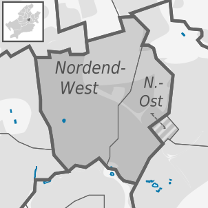
Frankfurt-Innenstadt III is a district of Frankfurt am Main . It is bordered on the west by Frankfurt-City II , in the northwest of Frankfurt-center-north , north-east of Frankfurt-North-East , to the east of Frankfurt-Bornheim / Ostend and in the south of Frankfurt-downtown I .
politics
Local council election on March 6, 2016
(Votes in percent)
%
30th
20th
10
0
27.9
20.9
20.0
10.3
8.7
7.1
4.1
1.1
Gains and losses
compared to 2011
% p
6th
4th
2
0
-2
-4
-6
-8th
-10
-12
-14
-16
-14.6
-1.3
+3.5
+3.9
+4.5
+3.3
+4.1
-3.3
Remarks:
g citizens for Frankfurt
After the 2016 local elections, the 19 seats of the City Center III local council are distributed as follows:
- GREEN : 5 seats
- CDU : 4 seats
- SPD : 4 seats
- The left : 2 seats
- FDP : 2 seats
- ÖkoLinX anti-racist list : 1 seat
- Citizens for Frankfurt (BFF): 1 seat
structure
Frankfurt City Center III consists of two districts:
- Northrend -East
- Northrend-West
Individual evidence
- ↑ a b Local council election 2016 on March 6, 2016 in Frankfurt am Main , accessed on Feb. 21, 2020
- ↑ Frankfurt am Main: Wahlanalysen 2011 , accessed on Feb. 21, 2020


