
Marbachweg
| Marbachweg | |
|---|---|
|
|
|
 |
|
| The Marbachweg ends at the Eschersheimer Landstrasse | |
| Basic data | |
| place | Frankfurt am Main |
| District | Preungesheim , Eckenheim , Dornbusch |
| Created | 1911 |
| Hist. Names | Thief way |
| Connecting roads |
Friedberger Landstrasse (east) Am Dornbusch (west) |
| Cross streets |
Homburger Landstrasse , Gießener Strasse , Eckenheimer Landstrasse , Kaiser-Sigmund-Strasse, Eschersheimer Landstrasse |
| Buildings | BRKZ , main cemetery |
| Technical specifications | |
| Street length | 2700 m |
The Marbachweg is a street in Frankfurt am Main . It was created in 1911 by renaming the thieves' path on the districts of Preungesheim and Eckenheim, which were incorporated on April 1, 1910 . The name comes from the Markbach , a small stream that marked the border between the territory of the imperial city of Frankfurt and the county of Hanau for centuries . The Marbachweg serves as an important cross-connection between the northern arteries of Frankfurt, the Eschersheimer Landstrasse , Eckenheimer Landstrasse , Homburger Landstrasse and Friedberger Landstrasse .
history
The Diebsweg was part of the Antsanvia , an old road leading from Mainz to Eisenach , which bypassed the territory of the imperial city of Frankfurt in the north. Until the end of the 19th century it was used as a dirt road through undeveloped terrain. After the incorporation of Preungesheim and Eckenheim, it was renamed Marbachweg in 1911. Only with the renaming did the gradual development of the street begin, initially from 1912 to 1914 in the western section and at the intersections with the arterial roads. Further construction projects followed in the 1930s, including the construction of the Marbach barracks in Eckenheim. After the Second World War, housing estates arose in Preungesheim, Eckenheim and in the Dornbusch district , which was formed in 1946 from parts of Eckenheim and Ginnheim . The name is reminiscent of the Frankfurter Landwehr , which was supposed to protect the borders of Frankfurt territory against attacks by neighbors from the 15th to the 19th century.
Today the Marbachweg is an important connecting axis north of the city center. The U 5 underground line runs over part of the Marbachweg .
course


The Marbachweg begins as a pedestrian and cycle path on Friedberger Landstrasse at the level of the Frankfurt-Friedberger Landstrasse motorway junction. The property with the house number Marbachweg 2 is already in the Seckbacher district and can only be reached via an access road from Friedberger Landstrasse from the north.
The Marbachweg crosses the A 661 motorway on a bridge reserved for bicycle and pedestrian traffic and then leads straight in a westerly direction through the Walter-Kolb-Siedlung , a residential area in Preungesheim. Beyond Homburger Landstrasse , the border between Preungesheim and Eckenheim, it becomes an avenue with two lanes separated by a green area. From here the Marbachweg is an important inner-city connecting road. At Gießener Straße , the U5 underground line turns right onto Marbachweg, the track of which lies between the two lanes. Immediately behind the intersection is the Gießener Straße underground station .
The 70 hectare main cemetery is located south of the Marbachweg . The center for fire protection, disaster control and rescue service (BRKZ), the most important location of the Frankfurt am Main fire brigade, extends north of the Marbachweg . In addition to the operations control center, it houses fire station 1, rescue station 1, the administration of the fire department as well as various workshops, training and practice rooms. The center was built from 1995 to 2005 on the site of the former Gibbs Barracks of the United States Armed Forces . The barracks area was laid out in 1936 as part of the armament of the Wehrmacht as a location for the telecommunications troops under the name of Marbach barracks .
There is an allotment garden to the west of the BRKZ , followed by the Eckenheim social center. The subway station Marbachweg / Sozialzentrum is located in front of the intersection with Eckenheimer Landstrasse . The underground line U 5 turns left towards the city center. The post office Frankfurt was built in 1986 on the corner property between Marbachweg and Eckenheimer Landstraße , today a branch of the Postbank and the seat of the operations center for banks .
West of the Eckenheimer Landstrasse, the Marbachweg reaches the Dornbusch district . The perimeter block development on the southern side of the street dates from before the First World War, while the Dornbusch-Ost settlement on the northern side was not built until the 1950s. At the confluence with Kaiser-Sigmund-Straße there is still a bunker built in 1943 , which is used by music groups as a rehearsal room.
West of Kaiser-Sigmund-Straße begins the Bertramsviertel , named after the approximately four hectare Bertramswiese , now a sports area, and the Bertramshof . It was built in 1888 as a dairy by Baroness Louise von Rothschild and is used today by the Hessischer Rundfunk . Anne Frank, born in 1929, spent the first two years of her life in the house at Marbachweg 307 . On the occasion of her 80th birthday, a memorial plaque was erected in front of the house in 2009.
The Marbachweg ends at the intersection with the Eschersheimer Landstraße. Its extension is the street Am Dornbusch .
Rail transport

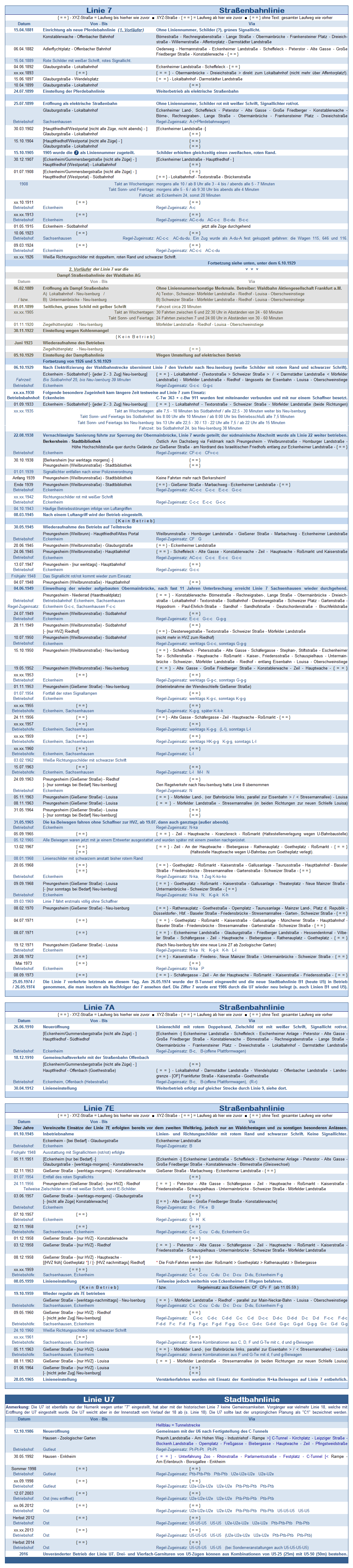
The extension of tram line 7 from Eckenheimer Landstrasse to Preungesheim, which opened on November 1, 1911 , initially ran south of Marbachweg and north of the New Jewish Cemetery, which opened in 1928 . Plans to expand the main cemetery made it necessary to relocate the tracks to Marbachweg in 1939. After the war ended in 1945, the US demanded the military government to create a new link between Eckenheimer and Eschersheimer highway in no time to the used by the American forces barracks in Preungesheim and Eckenheim to get away with the headquarters in the IG Farben Building to connect . To this end, the tracks in Koselstrasse and Hermannstrasse in Nordend, which had not been used since August 27, 1939, were expanded and relocated in Marbachweg. The new line was single-track, with the exception of a switch in the area of the Kaiser-Sigmund-Straße stop. As early as July 15, 1945, the new so-called Roundup Line 39 went into operation. The trains running on this line were initially painted olive green and reserved exclusively for American personnel. It was not until 1950 that the route now served by line 13 could be used by all passengers.
On May 25, 1974, tram line 7 ran on Marbachweg for the last time. The next day, with the inauguration of the B underground line under the old town, the new B1 line between Theaterplatz and Gießener Straße with the then new Pt cars went into operation. It was extended to Preungesheim in 1977 and renamed U5 in 1978. Since November 2016, the line has been used by the U5 light rail vehicles after the continuous conversion to elevated platforms .
Line 13 was shut down on February 25, 1978 because the line was considered illegal parallel traffic according to the traffic policy of the time after the impending start of operations on the Rhine-Main S-Bahn . The track on the western Marbachweg used since, after removing the alternate location only as the track operation, the occasionally for transfer trips between subway route B and subway route A is used.
At the intersection of Marbachweg and Eckenheimer Landstrasse, another operating line branches off to the north on Eckenheimer Landstrasse in the direction of the Eckenheimer Depot . It can be driven from both west and east and is used by the trains stationed here to push in and out of the U 5 line.
In the general traffic plan 2005 of the city of Frankfurt am Main a ring tram is planned, which is to run between Eschersheimer Landstrasse and Homburger Landstrasse through the Marbachweg. So far, your planning has not gone beyond declarations of intent.
Web links
Individual evidence
- ↑ Stadtvermessungsamt Frankfurt am Main (ed.): Portal GeoInfo Frankfurt , city map
- ↑ Chronicle of Line 7
- ↑ a b Route documentation for line 13 Berkersheim – Opernplatz
- ↑ Chronicle of the line 13
- ↑ Chronicle of the U5 line