Kaiserstrasse (Frankfurt am Main)
| Kaiserstrasse | |
|---|---|
| Street in Frankfurt am Main | |
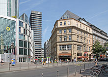
| The beginning of the Rossmarkt to Kaiserplatz | |
| Basic data | |
| place | Frankfurt am Main |
| District | Bahnhofsviertel , inner city |
| Created | Late 19th century |
| Connecting roads | Rossmarkt |
| Cross streets | At the main station , Gallusanlage , Neue Mainzer Strasse , Kaiserplatz |
| Buildings | Silberturm , Taunusbahnhof (†), Zinßerturm (†), Gallileo , Goethe Monument , Eurotower , Junior House , Commerzbank Tower , Frankfurter Hof |
| Technical specifications | |
| Street length | 950 m |
The imperial road is one of the most famous city streets in Frankfurt . It connects the Roßmarkt in the city center with the main train station . Before it was partially destroyed by bombs, it was a typical example of a grand urban Wilhelminian style boulevard in Frankfurt. It was built in two sections between 1874 and 1888. After the Second World War , Kaiserstraße, the main axis of the Bahnhofsviertel, became synonymous with the Frankfurt red light district , even if it is no longer one of them.
Location and course
Kaiserstraße is the only street in Frankfurt that bears the same name inside and outside the ramparts .
Inside the ramparts
The Kaiserstraße begins in the center of the city, at the Roßmarkt near the Hauptwache . It runs, lined with inner-city business and office buildings, from there initially in a south-westerly direction to Kaiserplatz , a star-shaped square into which five arms of the road flow. From the north, Kirchnerstrasse joins the square, from the south Bethmannstrasse and Friedensstrasse. On the north side of the square is the Commerzbank Tower ( Norman Foster , 1997, 259 m), the tallest skyscraper in Central Europe, on the south side the Wilhelminian style luxury hotel Frankfurter Hof ( Mylius / Bluntschli , 1876) and the Junior House from the 1950s ( Wilhelm Berentzen , 1951), a very early (and in its structural dimensions modest) example of Frankfurt high-rise construction. The granite fountain, donated by Frankfurt banker Raphael von Erlanger in 1876, stands on Kaiserplatz .
To the west of the square, Kaiserstraße continues and crosses Neue Mainzer Straße about 80 meters further . The intersection is in the heart of Frankfurt's banking district , and the view to the north into the street canyon of Neue Mainzer Strasse, spanned by pedestrian bridges, is a popular TV setting. Directly on the corner of Kaiserstrasse are the former Commerzbank high-rise ( Richard Heil , 1973, 109 m) and the K26 high-rise ( Köhler , 2005, 75 m). On the south side of Kaiserstraße is the corner house on Neue Mainzer Straße, built by Paul Wallot in 1875 , a Wilhelminian-style building in the Tuscan Renaissance style.
In the following short section to the Gallusanlage there is a historic bank building on the north side, also used by Commerzbank , on the south side of the Eurotower (Richard Heil, 1977, 148 m), which was originally built for the union's own bank for the common economy and from 1998 to 2014 was the headquarters of the European Central Bank (ECB). Today the Single Banking Supervision Mechanism (SSM) of the ECB resides here .
Gallus system
The Gallusanlage is part of the ramparts and was created from 1806 when the baroque city fortifications were converted into a park. The Goethe monument ( Ludwig von Schwanthaler , 1844) stood on the north side of the street until 2007, while the euro symbol known from television pictures and illuminated at night is on the south side in front of the Eurotower ( Ottmar Hörl , 2001).
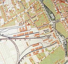
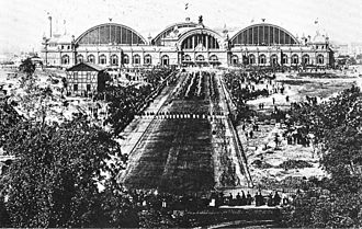
The older part of Kaiserstraße ends at the Gallusanlage road. Beyond the current lane, i.e. just outside the ramparts, was the Taunusbahnhof , the city's first train station , from 1839 to 1888 , with the Main-Neckar train station and the Main-Weser train station to the left and right of it . The older Kaiserstraße also had its current function as the main axis between the city center and the train station, but until 1888 not to the main train station, but to the western train stations .
From 1895 Manskopf's clock tower stood at the intersection of the two streets .
Outside the ramparts
The second construction phase could only take place after the opening of today's main train station (August 18, 1888) and the associated closure and the demolition of the western train stations. A new urban district of the Wilhelminian style, the Bahnhofsviertel , was built on the area that had become free . As the central axis of the new city quarter and the new splendid boulevard, the continuation of Kaiserstraße was created, which leads from here as a dead straight to the central portal of the main station.
The former Hotel Fürstenhof (Oskar Heussner, 1902), which has been used as a commercial building since 1920, is on the southern side of the street on the corner of the Gallusanlage . The Gallileo skyscraper is on the north side of the intersection ( Novotny / Mähner , 2003, 136 m). The English Theater is located on the publicly accessible ground floor . An older skyscraper, the Zinßerturm used by Dresdner Bank (Brösicke / Drevermann, 1951) , had previously stood on the same property .
The following, western half of Kaiserstrasse is a metropolitan-looking boulevard with magnificent five-storey Wilhelminian-style commercial buildings, wide sidewalks and numerous street cafes . The international atmosphere is underlined by the many representations of foreign airlines and tourism authorities.
At the corner of Weserstraße , Jürgen-Ponto-Platz opens to the north , named after the group's spokesman for the executive board who was murdered by the RAF in 1977 . This is where the Deutsche Bahn silver tower stands , which was the tallest building in Germany from 1978 to 1990 and was part of the Dresdner Bank corporate headquarters until 2008.
While Weserstraße leads in a straight line from Main to Westend, the following cross street, Elbestraße , is visually delimited on both sides: in the south by a large commercial building on Gutleutstraße , while in the north the narrow side of the Frankfurt Büro Center high-rise (Richard Heil, 1981 , 142 m) is exactly in the line of sight of Weserstraße and can therefore also be clearly seen from Kaiserstraße.
Between Weserstrasse and Moselstrasse on the north side of the street is the “Kaiser Passage”, a conglomerate of backyard passages from the 1970s, in which almost exclusively foreign shops are based, many of them from the Near and Middle East, especially Arab Countries and Iran.
On the north side of the street there are still a few cinemas and shops for the adult entertainment industry, which point to the Frankfurt red light district , which is directly to the north .
On the corner of Moselstrasse is the Kaiser-Friedrich-Bau, one of the most splendid Wilhelminian-style commercial buildings in the station district, and another on the corner of the station forecourt at the main station with the former Englischer Hof hotel .
The confluence with Bahnhofsplatz is closed to car traffic, Kaiserstraße is a dead end from Moselstraße. The last 50 meters before the station square are pedestrian zones and are dominated by the huge escalators that lead to the underground shopping arcade under the station square. Until the 1990s, the main station could only be reached on foot through the underpass, and since then there has been a crossing again using a pedestrian light signal, which also makes it easier to reach the tram stop.
A weekly market takes place in this westernmost section of Kaiserstrasse . This section of the street was at times the focus of drug trafficking and, under the derogatory name Kaisersack - an allusion to the fact that the Kaiserstraße ends as a dead end towards the main station - receives a lot of attention from the city press.
Origin and history
The upper Kaiserstraße between Roßmarkt and Taunusanlage was built in 1874. Even then it was the main axis to the most important railway junction in Frankfurt at the time, the Westbahnhöfen . This is where the Taunus Railway , the Main-Neckar Railway and the Main-Weser Railway ended . These systems were replaced in 1888 by the main train station, about one kilometer further west. The former track apron of the western train stations between this and the new main station was won as a new district. This is how the Bahnhofsviertel was created , the central axis of which is Kaiserstraße. Therefore, most of the houses on the street date from the Wilhelminian era at the end of the 19th century. Some of them have been or are being renovated.
From 1947 to 1955 the street was called Friedrich-Ebert-Straße . The renaming was not very popular among the population. The Frankfurter Bezirksvereine working group organized collections of signatures and protests at the municipal and state government. In a night and fog campaign, active members of the Frankfurt-Leipzig fraternity Arminia pasted over all street signs with the original name and informed the press. After the SPD (which had the majority in the city council) changed its mind, the city council decided on May 12, 1955, to rename it to Kaiserstraße on June 9, 1955, the day of the rededication of the Kaisersaal in the Römer. In return, the Platz der Republik (until 1923 Hohenzollernplatz) was renamed Friedrich-Ebert-Anlage with the exception of the Mainzer Landstrasse intersection with effect from June 9, 1955 . At the same time, the newly created east-west inner-city connection "Strasse an der Paulskirche" was renamed Berliner Strasse .
The Gallileo high-rise was built on the corner of Gallusanlage and Kaiserstrasse, with the English Theater located in the basement . At the beginning of Kaiserstraße on Rossmarkt , the Drei-Kaiser-Bau has been standing since 1894 (today, however, as a result of war damage and reconstruction) .
Todays situation
After the destruction of World War II by the air raids on Frankfurt am Main and the wave of destruction against buildings of historicism in the 1960s and 1970s, it is one of the last remaining boulevards in Frankfurt.
It is often viewed as part of the Frankfurt red light district . However, this only applies to the part near the main train station and here, too, red light companies have become rare. In the vicinity of the city center there are no more porn cinemas and cheap shops, instead there are more cafes and jewelers . The tolerance zone for prostitution only begins a few steps further down the northern side streets. So there are no brothels on Kaiserstraße itself , only in the cross streets and in the parallel Taunusstraße .
Another part of Kaiserstrasse fell into disrepair over the years because property speculators were relying on designation as office space. Two buildings from the bankruptcy estate of the real estate developer Jürgen Schneider , which are now owned by banks, also deteriorated. Numerous houses in the district and along Kaiserstraße are currently being redeveloped through a funding program from the city worth 10 million euros . The two houses from Schneider's bankruptcy estate are also currently being renovated.
On the side facing the station there are numerous brothels and table dance bars in the side streets. The attempt to displace prostitution and the open drug scene from the station district by changing the restricted area ordinance failed in the 1980s due to political resistance.
traffic
The Kaiserstraße has been an important inner-city traffic axis since its construction. Since the 1970s, however, the main load of road traffic has been routed via streets running parallel to it, and Kaiserstraße today only has a moderate exposure to motor vehicles.
The development by the public transport takes place today through the express train stations Hauptbahnhof and Willy-Brandt-Platz .
Trams used to run along the entire course of Kaiserstraße . The eastern section of the road ( intra muros ) was used by horse-drawn trams from May 13, 1880 , the western section ( extra muros ) from April 15, 1889. Around 1900, the route was electrified and Kaiserstraße became one of the most important axes of tram traffic. After the introduction of line numbers on October 15, 1905, it was used by lines 10, 11, 12, 13, 15, 16 and 18. Other tram routes crossed at the main station, along Neue Mainzer Strasse and in Friedensstrasse. The Wendeschleife Schauspielhaus of the Frankfurter Lokalbahn was located at the Gallusanlage , which ran from here to Bad Homburg vor der Höhe and Oberursel (Taunus) .
In the course of the reconstruction after the Second World War, the large tram nodes in the city center were completely redesigned and, above all, the stop areas were pulled apart at points with many intersecting routes. In order to make the intensively used stops at the main train station more efficient, the line through Kaiserstraße was closed on November 12, 1950 and the tram lines were routed over the lines through Taunusstraße and Münchener Straße, from where it was cheaper to turn into the stops. From 1906 to 1932 there was no tram traffic on the western Kaiserstraße; the trams instead drove through Kronprinzenstraße, today's Münchener Straße.
The tram route between Kaiserplatz and Gallusanlage was shut down on November 4, 1973 when the U-Bahn opened, the easternmost section between Roßmarkt and Kaiserplatz / Friedensstrasse on October 11, 1986 with the creation of the so-called “ rail-free city center ”.
Kaiserstraße has been connected to the subway since November 4, 1973 , on that day the A route was extended to the new Theaterplatz station (lines U1 – U3, today Willy-Brandt-Platz). In the north, the station was given an exit to Kaiserplatz and Kaiserstraße. The station on the B line (lines U4 / U5) went into operation on May 26, 1974, making Theaterplatz the first transfer station in the Frankfurt subway network.
On May 28, 1978, the rapid transit junction under the main station was opened, since then the U-Bahn (B-line / U4) and the city tunnel of the S-Bahn cross and open up the western station district including the local part of Kaiserstraße.
In the media
The well-known Croatian singer Siniša Vuco (* 1971) sings about Kaiserstraße on his seventh album Vrati se, vrati from 2002 with the song Calen bite ( transcribed for: numbers please) ( refrain : “Kajzer štrase, Kajzer štrase [... ] “) And the red light district.
Web links
Individual evidence
- ↑ Stadtvermessungsamt Frankfurt am Main (ed.): Portal GeoInfo Frankfurt , city map
- ↑ A good decision. In: Frankfurter Allgemeine Zeitung , April 28, 1955, p. 8
- ↑ Ernst Nebhut / Ferry Ahrlé , page 92 / H. de Rouet: 150 years of Frankfurt-Leipzig fraternity Arminia. Frankfurt 2010, p. 209.
- ^ Frankfurter Allgemeine Zeitung, June 1, 1955, p. 9
- ↑ 1880. In: el-citaro.de
- ↑ Line network map 1890. In: el-citaro.de
- ↑ Line network plan 1905. In: el-citaro.de
- ↑ Line network plan 1951. In: el-citaro.de
Coordinates: 50 ° 6 ′ 31 ″ N , 8 ° 40 ′ 10 ″ E


