Galluswarte (square)
| Galluswarte | |
|---|---|
| Place in Frankfurt am Main | |
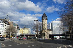
 View from Kleyerstrasse to the Galluswarte with the watch tower and railway bridge |
|
| Basic data | |
| place | Frankfurt am Main |
| District | Gallus |
| Confluent streets | Mainzer Landstrasse , Hufnagelstrasse, Camberger Strasse, Weilburger Strasse, Kleyerstrasse |
| Buildings | Wartturm of the same name , S-Bahn station , nearby: formerly Adlerwerke |
The Galluswarte is a town square in the western inner city of Frankfurt am Main . It forms the center of the Gallus district . Similar to the Bockenheimer Warte , the Hauptwache or the Konstablerwache , the name of the square goes back to the most important local building, the Galluswarte , built in 1414 , one of the four surviving waiting towers of the Frankfurter Landwehr .
location
The Galluswarte is centrally located in the Gallusviertel. Along with Platz der Republik and Güterplatz, it is the most important town square on the inner-city section of Mainzer Landstrasse . The course of the road makes a noticeable bend here. The axis of the inner city section of Mainzer Landstrasse continues from here in Kleyerstrasse . To stay out of town on Mainzer Landstrasse, a slight right turn has to be taken. Between Kleyerstraße and Mainzer Landstraße, i.e. on the west side of the square, there is a very acute-angled corner property.
In industrial times, the Galluswarte was the main entrance to the Adlerwerke , built in 1889 . a. Bicycles, typewriters and cars were produced and the factory buildings of which have been preserved are still an impressive sight from the Galluswarte. Kleyerstraße, formerly Höchster Straße , today bears the name of the founder of the Adlerwerke, Heinrich Kleyer .
Hufnagelstrasse leads to the square from the north. In the course of the street fighting in Frankfurt in the 1970s and 1980s, on September 28, 1985, during a demonstration against an NPD gathering, the protester Günter Sare was run over by a police water cannon on the corner of Hufnagelstrasse and Frankenallee and killed.
Two streets also lead from the south to the Galluswarte, the Weilburger Strasse leading to the south side of the former Adlerwerke and the Camberger Strasse. This leads to the Camberger Bridge , which crosses the track apron of the main train station and connects the Gallus with the Gutleutviertel , neighboring to the south .
In the middle of the square, between the lanes of the five-lane Mainzer Landstrasse and its cross streets, stands the actual Galluswarte, the 15th-century watch tower, the landmark of the Gallusviertel. The tower and square are currently the subject of a planned, smaller redesign (see article on the tower ).
railway station
The eastern boundary of the square is formed by the seven-track high-altitude route of the Main-Weser and Homburg Railway , which has been crossing the Mainzer Landstrasse on three parallel viaducts since 1888 as a new connection to the Centralbahnhof that was opened at the time . North of Mainzer Landstrasse, parallel to Günderrodestrasse up to Frankenallee , lies the Galluswarte S-Bahn station , which opened here when the S-Bahn was introduced in 1978 and is served by the S3 to S6 lines. It opens up the central Gallusviertel both for the residents and for the numerous jobs in the surrounding area.
tram
The tram lines 11, 14 and 21 run along Mainzer Landstrasse. During rush hour, some trains run on the branch line that branches off here through Kleyerstrasse and Rebstöcker Strasse, which further west, shortly before the railway bridge of the Taunusbahn , joins Mainzer Landstrasse. At the Galluswarte there is a very short way to change from the S-Bahn station to the tram stop directly below.
Individual evidence
- ^ Website Triumph-Adler : Adlerwerke 1880 - 1914
- ↑ Frankfurter Rundschau: Günter Sares death is still unclear. September 18, 2003, accessed April 18, 2018 .
Coordinates: 50 ° 6 ′ 10.5 ″ N , 8 ° 38 ′ 38 ″ E


