
Bornheimer Hang settlement
|
|
|
|---|---|
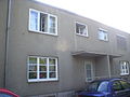
 Houses in the Bornheimer Hang settlement |
|
| Basic data | |
| Population : | 3,702 |
| Creation time: | 1925-1929 1951-1953 |
| location | |
| District : | 4 - downtown IV |
| District : | Bornheim |
| District : | 28 1 , 29 0 |
| architecture | |
| Architectural style: | classic modern |
| Urban planner: | Ernst May |
Coordinates: 50 ° 8 ' N , 8 ° 43' E

The Bornheimer Hang settlement is a residential area in Frankfurt - Bornheim above the Bornheimer Hang . It was planned by the architect and city planner Ernst May in the second half of the 1920s as part of the Neues Frankfurt residential construction project.
Description and history

The Frankfurt City Councilor Ernst May built this large housing estate with Herbert Boehm on the Bornheimer Hang between 1925 and 1930. In contrast to almost all other May settlements, it was an extension of existing buildings , not a satellite town . In the Pestalozzi and Florstädter Strasse, houses with pointed gable roofs that were atypical for Ernst May were built, in contrast to the otherwise usual flat roofs , in order to better adapt the appearance to the existing buildings . These houses have vertical window strips on the stairwell windows. Only a few houses on Florstädter Straße have preserved the original shape of the stairwell window strips almost down to the floor. In the other houses, the house and courtyard doors were renewed over the decades, thus cutting the ribbon windows over the door frame .
The construction has been accelerated by the use of industrially prefabricated parts so that in four years 1,234 apartments were completed. The buildings with flat roofs have functionally optimized floor plans and a high level of open space with a loosened-up row construction and roof terraces . In addition to apartment blocks , a few row houses were also built in the settlement . The estate comprises a total of around 1540 apartments (2- and 3-room apartments from 55 to 65 m², equipped with a Frankfurt kitchen and central radio ). The client was the limited company for small apartments. In addition to the Bornheimer Hang settlement, the Rotenbusch settlement was planned east of it in the Riederwald , but was not implemented. The community house planned at the end of Wittelsbacherallee was also not realized, so that space was available for the construction of a church . The area under the plane trees in two rows in Wittelsbacher Allee served as a marketplace for a long time . An indoor swimming pool planned by Carl-Hermann Rudloff on Pestalozziplatz was not built. Later the space provided for the Pestalozzibad was used for a kindergarten and today for a day care center.
The continuous ribbon windows on the houses on Wittelsbacher Allee are unusual for houses in the May settlements. Gardens on Bornheimer Hang were offered to the residents of the settlement for lease . The houses in Ketteler Allee between Löwengasse and Buchwaldstraße are equipped with roof gardens that can be used by residents whose apartments do not have balconies . The parks on Bornheimer Hang were designed by the Frankfurt horticultural director Max Bromme and his colleague Ulrich Wolf.
In 1995, a square at the confluence of Inheidener Straße and Wittelsbacher Allee in the center of the settlement was named after Ernst May. The terminus there of line 14 of the Frankfurt tram was renamed by the operator Stadtwerke Frankfurt from Inheidener Straße to Ernst-May-Platz .
The planned handover of a shop in the estate as an office to the Ernst May Society did not materialize.
architecture


The settlement also includes the Holy Cross Church of the church builder Martin Weber , which was completed in 1929 at the eastern end of Wittelsbacher Allee as a steel frame construction with a flat gable roof . The architect referred to the church as the “slope crown”, as it “crowns” the slope when viewed from below. Since July 2007 it has housed the meditation church Center for Christian Meditation and Spirituality of the Limburg diocese . The location of the church was chosen so that it is right in the middle of the field of vision for the viewer driving on Wittelsbacher Allee in the direction of Bornheimer Hang. Through the bend that Wittelsbacher Allee makes at the level of the tram - turning loop , the viewer looks at the south-western corner of the church tower and the large flight of stairs . On the southern outer wall of the tower , the beams supporting the belfry end in four winged animal figures with the heads of humans , lions , bulls and eagles , which symbolize the four evangelists Matthew , Mark , Luke and John .
The settlement also includes a municipal youth center , which is located on the corner of Ortenberger Straße / Löwengasse opposite the rectory of the Holy Cross Church and has been renovated since 2010.
At the turning loop and boarding stop of the tram on Ernst-May-Platz there is a row of shops that still serves its original purpose and is presented in a true-to-original look.
The Charles Hallgarten School below the Bornheimer slope, like the Holy Cross Church, should be located in the center of the settlement. Because the Rotenbuschsiedlung was not built below the slope, it is now in a peripheral location. She is a special school (special school for learning assistance), was designed by Ernst May and is now a listed building . The building was designed as a so-called open space school in the triangle between the districts of Bornheim , Seckbach and Riederwald ; it is located on a generous with trees passing property in the middle of a series of small gardens below the panoramic bath and the Sports Center Bornheim the Turngemeinde Bornheim .

House of the Bornheimer Hang settlement with a pointed gable roof in Florstädter Strasse

House of the Bornheimer Hang settlement with roof terrace and pointed gable roof in Pestalozzi Straße


Houses on Kettlerallee, as it was in 2003
One of the row houses, condition 2003

Administration building of the Charles Hallgarten School


.JPG)
.JPG)

Monument protection
The Bornheimer Hang settlement is a listed building as a whole . The entire complex includes Florstädter Strasse 1-23, Inheidener Strasse 2-44, 19-31, Karl-Albert-Strasse 1-47, 2-48, Karl-Flesch-Strasse 1-29, Kettelerallee 25-43, 51-75 , Ortenberger Straße 1-57, 42-58, Pestalozzistraße 2-30, Saalburgallee 21-23, 25-37, Wittelsbacherallee 140-190, 157-179, 195-201, 203-205.
Transport links

On February 28, 1931, the settlement was opened up by the Frankfurt tram for local public transport (ÖPNV). The terminus of line 14 is at the northern end of Wittelsbacher Allee near the Bornheimer slope. The tram's turning loop is located at today's Ernst-May-Platz at the lower end of Inheidener Straße . It is also of today's bi-directional - railcars of VGF still used. Line 14 has been running since December 2018 via the old town route and Frankfurt Central Station to Gustavsburgplatz in Frankfurt-Gallus . On November 17, 1952, the settlement was opened up by another tram line that runs past it in Saalburgallee. Since 30 May 1992, the settlement is further from the rail -line U7 the Frankfurt U-Bahn in the station underground ice rink approached which is part of the C-track is. From there there are connections to Enkheim and via the Konstablerwache to Praunheim - Heerstraße . The bus line 38 connects the Panoramabad and the settlement with the district center and the neighboring district of Seckbach .
Way of St. James
A branch of the German Way of St. James runs below the Bornheimer slope in the east of the settlement . This is based on the course of the historic long-distance trade route from Leipzig to Frankfurt am Main ( Des Reiches Strasse ). It begins in the episcopal city of Fulda , leads via Schlüchtern , Steinau an der Straße , Bad Soden-Salmünster , Gelnhausen , Langenselbold , Erlensee and Bruchköbel and belongs to the network of the main routes of the Jacob pilgrims in Europe , which lead to Santiago de Compostela . It leads over a total of 116 km past the Heilig-Kreuz-Kirche via the Ostpark to the bank of the Main in downtown Frankfurt , along the Main to the Eiserner Steg , on the left bank path towards Mainz and then on to Trier .
See also

- Ernst May
- New Frankfurt
- Frankfurt-Bornheim
- Bornheim slope
- Holy Cross Church (Frankfurt-Bornheim)
- Charles Hallgarten School
- Route of today's tram line 14
- Underground line C (Frankfurt am Main)
- Center for Christian Meditation and Spirituality of the Diocese of Limburg
Web links
- Bornheimer Hang settlement on the Ernst May Society website
- The May settlements in Frankfurt am Main
Individual evidence
- ↑ Statistical Yearbook 2008 City of Frankfurt accessed on Feb. 26, 2020
- ^ Hermann Gille, P. Helmut Schlegel : Catholic Holy Cross Church Frankfurt-Bornheim . Schnell und Steiner publishing house, Regensburg 2009, ISBN 978-3-7954-6808-8 .
- ↑ Christina Treutlein, Eckhard Herrel: "Utopias of the New Frankfurt - A Swimming Pool for Pestalozziplatz - The Design by Carl-Hermann Rudloff" . Catalog folder for the exhibition of the same name 26.7. - 22.12.2015 in the Ernst-May-Haus. Ernst May Society , Frankfurt am Main 2015.
- ↑ a b Helen Barr, Ulrike May, Rahel Welsen: The New Frankfurt - Walks through the Ernst May settlements and the architecture of his time . B3 Verlag, Frankfurt 2007, ISBN 978-3-938783-20-7
- ↑ Article. In: FAZ , September 30, 2004
- ^ State Office for the Preservation of Monuments Hesse (ed.): Bornheimer Hang Settlement In: DenkXweb, online edition of cultural monuments in Hesse
- ↑ rmv.de : Rhein-Main-pleasure - St. James. ( PDF ) (No longer available online.) Rhein-Main-Verkehrsverbund , April 11, 2011, archived from the original on March 28, 2016 ; accessed on December 2, 2019 .
- ↑ rmv.de : Rhine-Main pleasure hiking map: The Way of St. James from the Fulda to the Main. Rhein-Main-Verkehrsverbund , 2014, accessed on December 2, 2019 .