
Either way
| Either way | |
|---|---|
|
|
|
 |
|
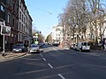
| Corner of Mittelweg and Bornwiesenweg | |
| Basic data | |
| place | Frankfurt am Main |
| District | Northrend |
| Created | Mid to late 19th century |
| Connecting roads |
Eckenheimer Ldstr. (North) Eschenheimer Anlage, Eschenheimer Tor (south) |
| Cross streets |
Holzhausenstrasse , Glauburgstrasse , Wolfsgangstrasse , Adlerflychtplatz, Paul-Hindemith-Anlage |
| Buildings | Holzhausentor, Volksbildungsheim, ev. Epiphany Church |
| Technical specifications | |
| Street length | 1325 m |
The Oeder Weg is a central street in the Frankfurt district of Northrend .
location
The road runs from the system ring at the level of the Eschenheimer Tor in a slight increase out of town to the north. It joins the Eckenheimer Landstrasse south of the German National Library just before the Alleenring .
Origin of name
The name of the Oeder Weg is derived from the formerly bordering lands of some of the lonely courtyards at the gates of the historic Frankfurt city fortifications . The Oeder Weg led from the Eschenheimer Tor to these agricultural properties of Frankfurt patricians . These included the Holzhausen-Oede (in which the Holzhausenschlösschen was built in the 18th century ), the Glauburger Hof, the Schwarzburger Hof and the Stalburger Oede . The names of the streets Holzhausenstraße, Schwarzburgstraße, Glauburgstraße and Stalburgstraße, which flow into Oeder Weg today, are references to this history of the street.
traffic
In accordance with its importance as the main street in the north end, the Oeder Weg is a busy street. The main part of motor traffic is individual traffic. There is also delivery traffic with small vans and trucks. Traffic is regulated by traffic lights in several places, so that there are always gaps in the flow of traffic that allow passers-by to cross the Oeder Weg without major problems.
In the southern 240 meters between Eschenheimer Tor and Jahnstraße / Querstraße, Oeder Weg is a one-way street going out of town. Traffic coming from the north is directed through the cross street to Eschersheimer Landstraße .
The bus line 36 and on weekends the night bus line n3 run through Oeder Weg .
Significance and development
Southern section
The southern beginning of the Oeder Weg is dominated by the former people's education center , which has housed the Cinestar-Metropolis multiplex cinema since 2000 . In the further course up to the level of the Adlerflychtplatz , the Oeder Weg is an important shopping street in the north end. Retail and specialist shops from all sectors, craft businesses, service providers and restaurants determine the appearance of the buildings' ground floors. The gymnastics department of Eintracht Frankfurt has its traditional headquarters in Oeder Weg 37 .
The development in this section of the street alternates between old buildings from the Wilhelminian era that survived the Second World War , residential and commercial buildings from the post-war period and several modern multi-purpose buildings erected after 1980.
Northern section

North of Adlerflychtplatz, the picture of Oeder Weg changes: there are only upper-class residential buildings and a few villas from the Wilhelminian era, there are no more shops. The former entrance gate of the Holzhausenpark is located on Paul-Hindemith-Platz.
To the north of Holzhausenstrasse, on the east side of Oeder Weg, stands the striking building of the Protestant Epiphany Church . Built in 1901 from limestone in the neo-Gothic style as Immanuelkirche , it was badly damaged by bombs during World War II. In the remaining ruins with the largely preserved tower, a new building in the style of the time was set in 1956. For the 50th anniversary of the reconstruction, in 2006, the church was extensively renovated.
Picture gallery
- Impressions from the Oeder Weg

View from the cross street to Eschenheimer Tor
Adlerflychtplatz

Paul-Hindemith-Platz and wooden house gate

Epiphany Church


Historical
The Lucius & Saul chemical factory

One of the first industrial areas in Frankfurt was located in Oeder Weg 9 in the 19th century. Today, however, there is no longer any trace of that to be seen. On 23 June 1836, entrepreneur Friedrich Wippermann took here the first steam engine of the Free City of Frankfurt for its existing there since 1825 Farbmüllerei in operation. The steam engine came from the company S. Dobbs and Franz Nellessen in Aachen . “The kettle had a cylindrical shape and was riveted from rolled iron plates, its inside width was 2 feet, 5 inches, 9 lines, its length in the sides 16 feet, 3 lines and an average of 16 feet, 8 inches, 9 lines and held one Proof of 139 8/10 pounds to the square inch. "
In 1858 he sold his pulverizing facility F. Wippermann to the chemist Eugen Lucius and the technician Johann Friedrich Saul , who renamed the company Chemische Fabrik Lucius & Saul . On August 13, 1858, Lucius and Saul received permission in the factory to manufacture and sell “the products that have been manufactured in the same factory since then, as well as chemical and technical products and preparations, paints, pharmaceutical woods, salts etc.”. Lucius was one of the co-founders of the paintworks Meister Lucius and Brüning in Höchst in 1863 , but still kept his Frankfurt factory.
In 1864 Saul left the joint company in Oederweg, which from then on operated under the name of the factory for pharmaceutical and chemical preparations, the factory for cocoa masses and chocolates, the steam mill and the pulverizer E. Lucius . Paul Friedrich Schumacher from Stuttgart became the new partner in 1866 . In 1874 Lucius sold the factory to the entrepreneur FA Büdingen .
Former tram
In 1891 the Frankfurter Trambahn-Gesellschaft opened a horse-drawn tram in Oeder Weg. The line ran from the main train station to the main cemetery . It was taken over by the municipal tram in 1899 and electrified in 1900. In 1964, the line was shut down when the construction of the subway at Eschenheimer Tor began .
post war period
From April 1945 to June 1948, the left side of the street between Wolfsgangstraße and Adickesallee formed the border of a restricted area that the American occupation forces had set up around their headquarters in the IG-Farben building and fenced off with barbed wire . All residents of this area had to leave their apartments with the entire inventory immediately and were only allowed to return after the abolition of the restricted area.
Web links
- Article of the Frankfurter Rundschau
- Pictures from the Oeder Weg
- Provider portal for service providers and businesses on the Oeder Weg
Individual evidence
- ↑ Stadtvermessungsamt Frankfurt am Main (ed.): Portal GeoInfo Frankfurt , city map
-
↑ All information on this section from: Volker Rödel, Fabrikarchitektur in Frankfurt am Main 1774 - 1924 , Frankfurt am Main 1984, ISBN 3-7973-0435-8 .
See also factory architecture in the north end
Coordinates: 50 ° 7 ′ 26 ″ N , 8 ° 40 ′ 52 ″ E