
Wilhelmshöher Strasse (Frankfurt am Main)
| Wilhelmshöher Strasse | |
|---|---|
|
|
|
 |
|
| Beginning of Wilhelmshöher Strasse, below Heinz-Herbert-Karry-Strasse, next to the A 661 | |
| Basic data | |
| place | Frankfurt am Main |
| District | Seckbach |
| Created | middle Ages |
| Connecting roads | Heinz-Herbert-Karry-Strasse (southeast), Vilbeler Landstrasse (northeast) |
| Cross streets | Heinz-Herbert Karry Street, Arolser street, at the Rosary Church, Atzelbergstraße, Old Bornstraße, the drive, Wichernstraße, Ellerstraße, Niedergasse, Am shooting Rain, Hofhausstraße, Leonhardgasse, Drais Bornstraße, Lohr alley On Kappel Garden, Seckbacher Bitzweg, Klingenweg, pilgrimage, Vilbeler Country road |
| Buildings | Hufeland House, Maria Rosenkranz Church , Zentgrafenschule , Seckbach Local History Museum , Marienkirche , Seckbach Old Lutheran School , Seckbach Town Hall , Henry and Emma Budge Home, schools of the German book trade |
| Technical specifications | |
| Street length | 4.55 km |
The Wilhelmshöherstraße in Frankfurt am Main is the main thoroughfare of the north-eastern district of Seckbach . It was named after the Kassel Wilhelmshöhe , a park with a castle , now a museum. This naming is related to Seckbach insofar as the former rural community temporarily belonged to the Landgraviate of Hessen-Kassel . The street creates a connection between the Frankfurt districts of Bornheim , Seckbach and Bergen-Enkheim .
Early days
Soil monuments
In the immediate vicinity of today's Wilhelmshöher Straße, in addition to prehistoric ground monuments, the relics of a Roman estate Am Klingen (near Klingenweg) and the remains of a giant Jupiter column from Roman times were discovered, now in the Historical Museum in Frankfurt . Finds from Roman times were made in 1877 in Niedergasse 7, which branched off from Wilhelmshöher Straße, in the parish garden in 1888 and 1909. At the time of the birth of Christ, a road from the Roman town of Nida (Heddernheim) to the Main. In addition to the street, Roman finds also include fountains, bricks, tools and coins.
The foundations of the St. Elisabeth mountain church (removed from 1757) were discovered in the old town of Kirchberg, which used to be between Seckbach and Bergen, roughly at the level of the current schools of the German book trade south of Wilhelmshöher Straße. At the time of the bubonic plague it was called the Kreuzkirche and was a pilgrimage church. For Seckbach, Bergen, Enkheim and Fechenheim the mountain church was the parish church. Within its foundation walls, further foundation walls of an even older, smaller church could be located. The former St. Elisabeth mountain church was significantly larger than the later St. Peter's Church in Seckbach and the Marienkirche , which was destroyed in the air raids on Frankfurt am Main in the Second World War and then rebuilt . The mountain church of St. Elisabeth and the earlier smaller church were built on top of a Roman sanctuary, which may be seen in the context of the nearby Roman estate.
Course of the road and history
Today's Wilhelmshöher Strasse was not built until it was incorporated into Frankfurt. It was formed from a section of Berger Strasse, Frankfurter Strasse, the former Breite Gasse, Höllstrasse and Kirchgasse.
Wilhelmshöher Strasse begins today at the Bundesautobahn 661 below Heinz-Herbert-Karry-Strasse (formerly Rotenburger Strasse), crosses the entire district and finally flows into Vilbeler Landstrasse , which was still called Mainkurstrasse in the southern section after the Second World War and in the north first Rumpenheimer Straße and in the extension Offenbacher Landstraße.


Both Seckbacher Landstrasse and Berger Strasse used to meet Wilhelmshöher Strasse, which began at the level of Eschweger Strasse at the Wolffhardtschen restaurant "Zum Heimgarten". This means that today's Heinz-Herbert-Karry-Strasse was previously called Rotenburger Strasse, but was part of Seckbacher Landstrasse before the Second World War. The first section of Wilhelmshöher Straße, which begins on the A 661 and ends at Wolffhardtschen Wirtschaft, was part of Berger Straße before the Second World War. Before the incorporation, the section between Eschweger Straße and Am Schießrain was called Frankfurter Straße, the adjoining section up to Leonhardsgasse was called Breite Gasse, the following section was called Höllstraße and the last section before Vilbeler Landstraße was called Kirchgasse.
As the former main street of the former rural community of Seckbach, Wilhelmshöher Straße has a village layout, so it is comparatively narrow and unsuitable for the masses of cars that have been streaming through for decades. The maximum permitted speed has therefore been reduced from 40 to 30 km / h. Mobile speed traps temporarily monitor compliance, especially below the Henry and Emma Budge home. Narrow sidewalks, some of which are only on one side of the street, make it difficult for pedestrians to cross oncoming traffic and to use them by wheelchair users, prams, bicycles and groups from kindergartens and schools. The local public transport (ÖPNV) operated with two RMV bus lines (38 and 43) increases the risk of accidents in Wilhelmshöher Straße and blocks traffic at stops and construction sites.
Before the so-called Osttangente Frankfurt or Taunusschnellweg was built, Wilhelmshöher Strasse was connected to Bornheimer Berger Strasse . In the course of the construction of the motorway, which crosses Seckbacher Landstraße, a circular so-called turning hammer and paved walking paths were created at the beginning of Wilhelmshöher Straße, which lead up to the green, short motorway enclosure and to two newly created circular squares of different sizes. These walking paths also establish the old connections to Berger Straße, but also to Seckbacher Landstraße. From this point on Wilhelmshöher Strasse, a steep staircase used to lead up to Rotenburger Strasse (today Heinz-Herbert-Karry-Strasse), while Wilhelmshöher Strasse with a narrow sidewalk on the outward side in a relatively steep curve at Bornheimer sports ground into the Berger Strasse passed. Between the residential development of the beginning Wilhelmshöher Strasse from the turn of the 19th and 20th centuries and the sports field, lush greenery protruded into the street on both sides.


Today Wilhelmshöher Strasse makes its first right bend where Heinz-Herbert-Karry-Strasse joins it and Arolser Strasse begins. From 1905 to 1970 this was the terminus of the Frankfurt am Main tram (line 22, later 2), which had a turning loop and a bus shelter with toilet for tram drivers and a kiosk. These facilities are still in place today, and the turning loop, which has long since been freed from the tram tracks, is still recognizable from today's street layout. Arolser Straße leads to the new Friedrich-Ebert-Schule , an integrated comprehensive school (IGS) and all-day school , built in 1977 , and in its extension to Huthpark . Before the Atzelberg was built, a narrow footpath ran between the allotment gardens past the Huthpark to the Im Staffel street.
From there, following the course of the Wilhelmshöher Straße, you come to the first left turn after a downhill stretch. On the right hand side is the entrance to the Hufeland-Haus, which opened in 1964, an elderly care center which, in addition to the inpatient care area, also has the oldest day care facility in Germany, an exercise pool (therapy pool, 32 ° C), an elderly care school and a public kindergarten. The next significant point is the dead end street An der Rosenkranzkirche, which branches off to the left, immediately afterwards the next confluence leads up to the car park of the Catholic Maria Rosenkranz community . This is at Wilhelmshöher Straße 67, but was built in 1952 well above the street on the then undeveloped Atzelberg. There used to be a butcher's shop across from the junction.
The first real road junction from Wilhelmshöher Strasse is a confusing intersection. Atzelbergstrasse branches off to the left and Altebornstrasse to the right. Attached traffic mirrors should enable an exit from these two streets into Wilhelmshöher Straße. Atzelbergstrasse leads into a larger new development area that was built in the late 1960s / early 1970s. From the Atzelberg you can reach the Huthpark and the Quellenwanderweg in Frankfurt's green belt . Altebornstraße leads to the building of the Seckbach volunteer fire brigade and to the old people's club. There was a gas station on one corner, as you can still see today.
At the next left bend in Wilhelmshöher Straße is the street Im Trieb which joins from the right (until the incorporation of Bergen-Enkheim in 1977: Triebstraße). It leads, among other things, directly to the landscape protection area and natural monument Sausee (locally also called Säusee).

Lot with Marienkirche in the historic center of Seckbach on Wilhelmshöher Strasse

Seckbach local history museum in the former Pedellhaus of the Seckbach New School (today: Zentgrafenschule )
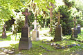
Historic cemetery of the Marienkirche on Wilhelmshöher Strasse
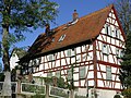
Old Lutheran School of Seckbach in Wilhelmshöher Straße 135, left Seckbach's war memorial 1870/71


The Wilhelmshöher Strasse gradually reaches the center of Seckbach. To the right is the Zentgrafenschule , a three to four-class elementary school with a preschool and all-day school. The Seckbach Local History Museum , which was set up in 2004 and uses the former Pedellhaus of the former Seckbach's New School, is located on their premises . Before that, you will pass a property on which one of Seckbach's three blacksmiths workshops once stood. On the left, above the memorial stone placed in 1980 for the 1100th anniversary of Seckbach, the former Lutheran and now Protestant St. Mary's Church from 1710 with its historic church or cemetery, where Roman artefacts were excavated. A winding staircase leads to her up a steep hill. At its apex is Seckbach's war memorial from 1870/71, which lists the names of the Seckbachers who fell in France in this war.
On the left, also in an elevated position on the slope, is the Old Lutheran School Seckbach from 1709. The local pharmacy is right next to it. At the beginning of the 20th century, Hannes , a historic fire alarm from Siemens & Halske, which was connected to the Frankfurt professional fire brigade in Bornheimer Burgstrasse via Morse code , was located roughly where there is now a bus stop . The Wichernstrasse branches off to the right, which later continues as a footpath in parts and, once again passable, opens into Niedergasse. To the left, Ellerstraße leads up to the Marienkirche and its community center.


Following the course of the Wilhelmshöher Straße, Niedergasse branches off to the right, which meets Hochstädter Straße. Niedergasse runs on an old cobbled Roman road. A Roman well, bricks, utensils and Roman coins were excavated here. On the right, at the site of today's MediZentrum Seckbach, there was once a petrol station, next to it a branch of the Bornheimer Volksbank, formerly Diehl department store. Then a modern, sober, low-rise supermarket with a mini-parking lot behind it reveals itself on Wilhelmshöher Strasse to the left, which in the 1970s was placed in the middle of the historic half-timbered development with little conservation, although there had been plans for a harmonious integration . After an interlude at Atzelbergplatz, it is the only remaining supermarket in the district. In its place, one of three Seckbach blacksmiths' workshops was previously operated. There used to be five grocery stores and one milk shop along Wilhelmshöher Strasse alone.
At the next intersection of the district, Wilhelmshöher Strasse meets Hofhausstrasse, which branches off to the left. Here the view immediately falls on the historic Seckbach town hall from 1542, which was used as such until June 30, 1900 and has been operated as a community center since 1993. In its extension, the winding Hofhausstraße leads to Friedberger Landstraße , the connection to Bad Vilbel . At the same intersection to the right, it goes into the residential street Am Schießrain. Here is the club's own gymnasium of the Seckbach 1875 gymnastics club , a former dance hall, in which public events also take place, for example carnival sessions.
If you follow Wilhelmshöher Straße, you will pass the long-established bakery (now a pizzeria) on the right. Originally the bakery was one of five different ones on Wilhelmshöher Strasse alone. One of three Seckbach blacksmiths' workshops stood on their present yard or parking lot. A little later you will pass the last butcher in the district on the left in a Z-curve. A number of restaurants should not go unmentioned, at least one of which currently has cult status in Frankfurt. It is right after the next right-hand bend in Leonhardsgasse. Leonhardsgasse leads, among other things, to the Seckbacher Ried nature reserve and to the terminus of the RMV bus lines 44 and F-41 as well as the stop of the n5, the connection to Frankfurt's night bus service. Until 1992 there was a tram stop for the Frankfurt am Main tram (formerly line 32, later 20, last 12), which initially connected the districts of Bergen and Seckbach through the industrial and commercial area of the Seckbacher Niederung with Borsigallee, the southern boundary of Seckbach. This tram line was later connected to Bornheim (Heidestraße) via the Riederwald district .
At the height of the local butcher's shop, next to Leonhardsgasse, Draisbornstrasse and Lohrgasse also flow into Wilhelmshöher Strasse. After the Z-curve that has been completed there, you will reach the streets Am Kappelgarten and Seckbacher Bitzweg going off to the left and right. The first leads through another new development area in the district that was built in the late 1970s. From there a footpath leads up to the Lohrberg .


After a steep ascent on Wilhelmshöher Straße and a right bend, you leave the actual residential development of the district and after a left bend you come to the Henry-und-Emma-Budge-Heim on the left, a care center for the elderly that had previously existed elsewhere in Frankfurt. inaugurated here in 1962, but was completely rebuilt in 2002 and enlarged considerably. Then the streets Klingenweg and Wallfahrtsweg merge into Wilhelmshöher Straße.
The pilgrimage route and the nearby Kirchgasse off the Klingenweg indicate that a church once stood here. This was the mountain church of St. Elisabeth, first mentioned in a document in 1178, in the old town of Kirchberg, which used to be between Seckbach and Bergen, about the same level as today's schools of the German book trade south of Wilhelmshöher Straße. The mountain church was a pilgrimage church at the time of the bubonic plague and was called the Kreuzkirche from 1349/50. During archaeological excavations, not only the foundation walls of this mountain church were discovered, but also those of a smaller church that must have existed before it and lay within the foundation walls of the mountain church. Both churches in turn were built on the foundations of a Roman sanctuary. This was possibly in the context of a Roman manor that was excavated nearby. The mountain church was last reformed and was removed from 1757. Its masonry was used by Saxon soldiers to fortify paths, but also by the Seckbach population for the construction of the reformed Seckbacher Peterskirche, which had been located in Wilhelmshöher Straße at the former eastern exit of the town, from 1834 as a second schoolhouse and was demolished in 1966. An apartment building was later built in its place.
A noticeable bump crossing Wilhelmshöher Strasse marks the former embankment for the tram tracks on the line between Bergen, Seckbach, Riederwald and Bornheim, which is now used as a walking or hiking trail. Wilhelmshöher Strasse then ends where it meets Vilbeler Landstrasse.
Transport links
Wilhelmshöher Straße is connected to the local public transport system of the city of Frankfurt with the RMV buses 38 and 43. The RMV bus route 43 crosses Wilhelmshöher Strasse almost completely. An indirect connection is achieved by the nearby RMV bus lines 44 and F-41 with their terminus at Leonhardsgasse. The night bus n5 also stops there.
literature
- Rochelmeyer, Folker: Seckbach und seine Umgebung , Frankfurter Sparkasse from 1822 - Polytechnische Gesellschaft (ed.), 1972, 84 p., Illustrated
- Rochelmayer, Folker (chronicle): Festschrift 1100 Years Seckbach, 880-1980 , Festschrift 1100 Years Seckbach e. V. (Ed.), 1980, 151 pp., Illustrated
- 50 years of culture and history association 1954 Frankfurt a. M.-Seckbach e. V. , dto. (Ed.), Ibid., 2004, 53 p., Illustrated
swell
- City of Frankfurt am Main, Institute for Urban History
- Society for History Frankfurt e. V.
- Culture and History Association 1954 Frankfurt a. M.-Seckbach e. V.
- Seckbach local history museum , Frankfurt am Main
- Shell city map No. 9 Frankfurt a. M., without indication of scale, Shell Reiseienst, 1934 or 1935
- Falk plan of Frankfurt, scale: 1: 16,500 - 1: 26,000, Falk-Verlag, Hamburg, 1947
- ↑ Stadtvermessungsamt Frankfurt am Main (ed.): Portal GeoInfo Frankfurt , city map
Web links
- Culture and History Association 1954 Frankfurt a. M.-Seckbach e. V.
- Website of the Hufeland House, Frankfurt am Main
- Website of the Zentgrafenschule, Frankfurt am Main
- Website of the Henry and Emma Budge Foundation, Frankfurt am Main
- Webcam Frankfurt-Seckbach, Wilhelmshöher Strasse with a view of the Lohrberg pharmacy and the Ellerstrasse confluence