Quellenwanderweg in Frankfurt's green belt
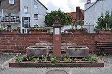
The Quellenwanderweg in Frankfurt's green belt is a signposted hiking trail 6 km long and about 60 m altitude difference in Frankfurt am Main . It leads past nineteen enclosed (walled) and unmounted springs , the history and historical use of which is described on the main hiking trail on information steles and boards on site. Five of the nineteen sources are a little off the beaten track and have no information boards. According to the prospectus of the city of Frankfurt, the hike takes about three hours (without breaks). The hiking trail is part of the nature reserve and recreational area of the Frankfurt Green Belt .
Course and geology
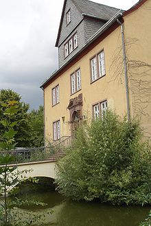
The hiking trail begins in the Seckbach district of Frankfurt at the source Alteborn ("old fountain") in Atzelbergstrasse. From there it leads north and northeast through the historic center of Seckbach over the ridge of the Lohrberg, which belongs to the Berger ridge, to the Bergen district , makes a loop there to the south through the Enkheim district and heads north back to Bergen. The end point of the hike, the nineteenth source, is the Schelmenborn , which fills the moat of the Schelmenburg in Bergen.
The springs along the hiking trail are stratified springs that are created by seeping rainwater at geological boundaries between rock layers. There the water collects over water-impermeable layers of marl . Where these impermeable layers meet the surface of the earth, the dammed water can emerge as a source.
The sources
Alteborn
The Quellenwanderweg begins at the Alteborn, a source that can be found on a slope between Atzelberg-Ost and Marienkirche next to a staircase to Zentgrafenstrasse. The name Alteborn stands for old spring. In earlier times, anyone could freely supply themselves with fresh water on a well without knowing about the bacteriological quality and the chemical composition of this water.
Bachgrund
The source Bachgrund rises on the Lohrberg. Together with the sources Pfingstgetrieschen, Pfingstlohr, Wüst and some brook ditches, it forms the Seckbacher Mühlbach at an altitude of 135 meters above sea level.
Draisborn
The Draisborn is a spring that rises on the Lohrberg and flows into the Mühlbach in the back alley.
Klingenborn
The Klingenborn rises on the eastern slope of the Lohrberg on Klingenweg at an altitude of 183.3 meters above sea level. For the water supply to Seckbach, the Klingelbach was collected from 1897 in an opposing container of the Seckbach waterworks on Lohrberg, via which Seckbach's east was still supplied with water until 1953. Today the Klingelbach flows piped into the Seckbacher Ried.
Hole well
The hole well emerges in layers and has a moderate pouring volume. Its source horizon is diffuse and swampy in character, the source version can no longer be made out today. Due to its near-natural appearance and the forms of vegetation for wetlands, it is very in need of and worthy of protection.
Mühlbach / Draisborngraben
The Seckbacher Mühlbach arises on the western slope of the Lohrberg at the level of the Am Lohrberg road through the confluence of the Lohrberg sources Bachgrund, Pfingstgetrieschen, Pfingstlohr, Wüst and some creek ditches at a height of 135 meters above sea level. Including its piped route, it has a total length of around one kilometer. Due to a near-natural conversion, it was moved back to its old bed north of the Seckbacher development. At the property at Alsfelder Straße 2 / corner of Hintergasse, under two beech trees, you can hear the rushing of the stream called Draisborngraben in a northeastern direction and take a look at the water. Since 1990 the stream has flowed into the nature reserve Seckbacher Ried and feeds the wetland.
Until the end of the 19th century, the former Seckbach watermill was driven by the Mühlbach, from which its name is derived. The former millstones are still in front of the Im Mühlchen building at Hintergasse 16 . At that time, the Mühlbach was dammed into several ponds and their water was drained to operate the mill.
Pentecost getrieschen
The source horizon of the Pfingstgetrieschen source is located within former leisure gardens on the slope of the Lohrberg, which the city of Frankfurt recently purchased with funds from the nature conservation law compensation levy in order to gradually renaturate the area of the source, which was previously intensively used. The name "Triesch" is of dialect origin and indicates that the spring was once located on an undeveloped area that served as a pasture for cattle. Your water runs to the Seckbacher Mühlbach.
Pentecost ear
The source gallery of the Pfingstlohr is today in the area of the leisure gardens on the Lohrberg slope and is therefore inaccessible. Its water forms the Seckbacher Mühlbach at a height of 135 meters above sea level with that of the Bachgrund spring and some brook ditches.
Desolation
The water from the Wüst spring, which rises on the Lohrberg, flows to the Seckbacher Mühlbach.
Former Seckbach waterworks
Pumping station
The former pumping station of the Seckbach waterworks from 1897 was located in Hintergasse 23 (today: Alsfelder Straße 23). It used two Seckbacher spring groups to obtain water. Spring water was collected in a 180 cubic meter suction shaft and directed to the pumping station via the property at Alsfelder Straße 12. The manhole covers can still be seen on the property mentioned today. The pumping station transported the water to the main collecting tank on Lohrberg.
Main collection container
The former main collecting tank of the Seckbach waterworks from 1897 is located in the street Am Pfingstlohr. It has a capacity of 300 cubic meters and is made of rammed concrete. Its highest water level was 160 meters above sea level. The water ran through a network of pipes from here to farms and households in the west of Seckbach. From 1903 there was a dual water supply together with the connection pipe to the municipal pipeline system, which, coming from the water park , ended in the Heimgarten villa colony.
Counter collection container
The former counter-collecting tank of the Seckbach waterworks from 1897 is located at the northern end of the Klingenweg on Lohrberg. It has a capacity of 100 cubic meters. Groundwater and surface water as well as the heavily pouring springs Draisborn, Pfingstlohr and Wüst were collected in it and pumped into the main collecting tank in the street Am Pfingstlohr via the former pumping station in Alsfelder Straße 23. Until 1953, households and farms in the eastern part of Seckbach were supplied with water from the counter-collecting tank. Due to its high location, its pipelines had a sufficient gradient so that Seckbach's water supply was not dependent on the pumping station.
gallery
literature
- The Quellenwanderweg in Frankfurt's green belt . Brochure of the environmental office of the city of Frankfurt, 4th edition July 2007
- The Quellenwanderweg in Frankfurt's Green Belt . Leaflet of the environmental office of the city of Frankfurt, new edition 2019
Web links
- Hiking map of the Quellenwanderweg on frankfurt.de
- Green belt information pages of the environmental office of the city of Frankfurt


